Dražgoše (Jelenšče) - Bela peč (Podbliška gora)
Starting point: Dražgoše (Jelenšče) (960 m)
| Lat/Lon: | 46,2523°N 14,1838°E |
| |
Time of walking: 1 h
Difficulty: easy unmarked way
Altitude difference: 198 m
Altitude difference po putu: 200 m
Map: Škofjeloško in Cerkljansko hribovje 1:50.000
Recommended equipment (summer):
Recommended equipment (winter):
Views: 3.490
 | 3 people like this post |
Access to the starting point:
a) Drive to Železniki, then continue to Dražgoše. Follow the main road through Dražgoše to the part of the village called Na Pečeh, where you turn slightly left onto a side road in the direction of Bičkova skala, Dražgoška gora and the hamlet of Jelenšče. Above the hamlet of Jelenšče, continue along the forest road, but only as far as the first crossroads, where you can park at a suitable place by the mountain signs.
b) Drive to Kranj, then follow the signs for Besnica (the turnoff from the old road Ljubljana - Kranj is before the bridge over the Sava River, or after the bridge if you are coming from the direction of Kranj). Continue through Spodnja, Zgornja Besnica and Njivica. A little further on, you arrive in Nemilje, and after this settlement the road starts to climb steeply. When you reach Podblica, follow the main road, and above Podblica you will reach the main road Kropa - Dražgoše, which you follow to the left (if the bend is too sharp, there is a turning point a few 10 metres to the right). Continue past the church of St. Jederti and then you will reach Dražgoše, where you will first reach a crossroads where the road to Sv. Križ turns left. Continue along the main road and then arrive in the centre of Dražgoše, where, at the area called Na Pečeh, take a sharp right onto a side road in the direction of Bičkova skala, Dražgoška gora and the hamlet of Jelenšče (the signs are from the opposite direction, so you can quickly miss them). Above the hamlet of Jelenšče, continue along the forest road, but only to the first crossroads, where you can park at the appropriate place next to the mountain signs.
c) Drive to Kropa, then continue towards Dražgoše and Železniki. When you arrive in Dražgoše, in the centre of Dražgoše, in the area called Na Pečeh, take a sharp right onto a side road in the direction of Bičkova skala, Dražgoška gora and the hamlet of Jelenšče (the signs are from the opposite direction, so you can quickly miss them). Above the hamlet of Jelenšče, continue along the forest road, but only to the first crossroads, where you can park at the appropriate place next to the mountain signs.
Path description:
From the starting point, turn right in the route Bičkova skala (Dražgoška gora, Kališe and Vodiška mountain pasture on the left) and follow the road as it climbs crosswise to the right. After about 10 minutes of walking, you will reach Bičkova skala, which is located a few steps to the right of the road and from where you will have a nice view of Dražgoše and the surrounding hills.
From Bičkova skala, continue along a narrow asphalt road that crosses steep and occasionally scenic slopes. Higher up, we are joined on the right by a path that leads along the slopes of Lajška Gora (this path is marked with local signs and is poorly maintained), and the road then turns slightly to the left and leads us to the Jelovice plateau.
Here, at the information board to the right, the marked trail continues, reaching Belo Pec via Riglov, and we continue along the road, which forks just a little further on. Continue along the right-hand road (the left-hand road will take you to Kališnik), and after a few minutes turn right onto the path that will take you to the nearby Bílá Peć.
Description and pictures refer to the situation in 2017 (December).

Pictures:
 1
1 2
2 3
3 4
4 5
5 6
6 7
7 8
8 9
9 10
10 11
11 12
12 13
13 14
14 15
15 16
16 17
17 18
18 19
19 20
20 21
21 22
22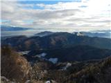 23
23 24
24
Discussion about the trail Dražgoše (Jelenšče) - Bela peč (Podbliška gora)
|
| plaNinaPirsMajcen3. 02. 2025 21:16:59 |
https://youtu.be/eRDQdkxggkw?si=ze-r37lb-tTrtn2N Včeraj smo s prijateljicami prehodile to pot. V videu do 1.40 minute. Štartale smo v Dražgošah (Jelenšče) in se mimo Bičkove skale podale na Podbliško goro. Pot ni markirana, a s sledljivostjo ni večjih težav. Je pa definitivno manj obiskana. Nazaj smo se en del vračale po cesti in tako nad Bičkovo skalo zaključile krožno pot čez Podbliško goro. Spustile smo se nazaj do avtomobila in šle v drugo smer še na Dražgoško goro. Ta pot je markirana, široka in precej enostavna. Na sonček, kot obljubljajo na lesenih klopcah (Dražgoše-pri nas je sonce doma), pa upajmo kdaj drugič 🌞 Lp, Nina
|
|
|
|
| georgia4. 02. 2025 19:26:48 |
Malo večji in bolj praktičen krog na omenjena dva vrhova: s P na Jelenščah najprej na Dražgoško goro (ta pot je precej obljudena), potem naprej mimo planine Kališnik vseskozi po gozdni cesti gori - doli do glavnega križišča gozdnih cest že blizu Bele peči, skok do Bele peči in spust po gozdni cesti (ali po stezici ob robu grebena) do asfalta nad Bičkovo skalo in sestop po tej cesti do P. Na tem koncu priporočam še obisk bližnje Britmance, ki je po novem tudi že opisana. 
|
|
|