Dom Planincev v Logarski dolini - Krofička (hunting path)
Starting point: Dom Planincev v Logarski dolini (837 m)
| Lat/Lon: | 46,3836°N 14,6216°E |
| |
Name of path: hunting path
Time of walking: 3 h 35 min
Difficulty: difficult pathless terrain
Altitude difference: 1246 m
Altitude difference po putu: 1246 m
Map: Kamniške in Savinjske Alpe 1:50.000
Recommended equipment (summer): helmet
Recommended equipment (winter): helmet, ice axe, crampons
Views: 9.793
 | 4 people like this post |
Access to the starting point:
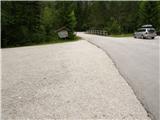
a) Via the Volovljek Pass (Kranjski Rak) or from Mozirje, drive to Luce, and from there continue towards the Logar Valley. A few kilometres after Solčava, you will reach a crossroads where you turn left towards Logarska dolina (toll). Continue along Logarska dolina, and we will drive to the Home of the Mountaineers in Logarska dolina. Park in the parking lot on the left side of the road. The parking lot on the right side is for the guests of the Planincev Dom Planincev.
b) Via Border crossing Jezerski vrh (Jezerski vrh) drive into Austria, and there in the Bela Valley / Vellach turn right in the direction of Border crossing Pavličev vrh (Pavličevo sedlo) / Paulitchsattel. When you reach the Slovenian side, first descend to the valley, then turn right at the junction a little before Solčava towards the Logar valley (toll). Continue along the Logar valley, and we drive to the Home of the Mountaineers in the Logar valley. Park in the parking lot on the left side of the road. The parking lot on the right side is for the guests of the Planincev Dom Planincev.
c) We drive to Črna na Koroškem (to get here from Raven na Koroškem or from Šoštanj via the Spodnje Sleme pass) and then continue driving to Luče. Initially still an asphalt road, higher up it becomes macadam and leads to a crossroads of several roads at Spodnje Sleme Pass. Continue along the main road, which begins to descend crosswise towards the settlement of Podolševa. At the crossroads below, take a sharp left (Solčava Panorama Road on the right - you can also reach the starting point by this road, in which case join the road over the Pavličev Vrh Pass) in the direction of Solčava. When you reach Solčava, continue right at the junction where you join the main road. A few kilometres after Solčava you will come to a crossroads where you turn left in the direction of the Logarska dolina (toll). Continue along the Logarska dolina, and we will drive to the Home of the Mountaineers in the Logarska dolina. Park in the parking lot on the left side of the road. The parking lot on the right side is for the guests of the Planincev Dom Planincev.
Path description:
From the parking lot, continue along the main road, which leads us over the bridge, and after the bridge, signs for Klemenča Cave direct us left to the forest road, which we continue along the path, which leads us in a few minutes to the crossroads, where we continue to the right in the direction of Klemenča Cave. From the crossroads, walk along the road for only a short time, as you then continue left along the initially wide and gently sloping mountain path. Just a few steps further on, the path passes onto a slope and gradually starts to climb steeper and steeper. The steep path continues up the steep slope, then crosses a torrential ravine and, a little further on, a small stream. After the stream, the path becomes even steeper and climbs up a very steep slope, which is particularly dangerous for slipping in wet conditions. After less than an hour's walk from the starting point, you reach a bench by a small well and just a little further on to a crossroads, where you join the path from the starting point at the crossroads.
Here the steepness eases, and we continue slightly up the wide path that soon leads us out of the forest. From here it is just a short climb up a grassy slope to Koča na Klemenči jami below Ojstrica.
From the hut at which the crossroads is marked, continue straight on in the direction of Ojstrica (left Strelovec and Krofička) along the path which goes after a few 10 metres into the forest. Through the forest we climb moderately to steeply, and the path leads us higher under the rocky cliffs, which are not too crumbly. The path soon gives way to the cliffs to the right and leads to a crossroads, where we continue left in the direction of Ojstrica along the Kopinškovi path (to the right Ojstrica, Planjava and Korošica over Škarje).
Further on, we pass out of the forest onto the dwarf pines covered slopes, which offer a beautiful view towards the north face of Ojstrica and Rjavčků Peak. The way forward leads us to the unmarked hunting trail to Krofičko.
When you see cairn (about 10 minutes before the Kopinškova trail crosses to the other side of the ridge), turn left onto a faintly visible path which leads you over a partly rocky and partly grassy slope, surrounded by dwarf pines and individual trees, to the foot of the north-western cliffs of Krofička. A short, very steep climb follows, which is overcome with the help of a rope, and the path leads to an initially narrow and exposed ridge. Grebenc, which is slightly overgrown with dwarf pines, then quickly widens and, with the help of some fixed safety gear, leads us to probably the most difficult part of the route. With the help of a rope ladder that has been damaged for several years (data from 2013), we climb the almost vertical and exposed chimney, which is about 10 m high. The steepness then quickly subsides and the path leads us to sunny meadows (the slope is called the Last Meadow), where the path gradually loses its way. The ascent continues transversely in a north to north-easterly direction on a gradually steeper and steeper slope. When you reach a fairly steep slope, you stop climbing transversely and continue straight up the very steep slope. If you want to avoid the last steep climb, you can continue slightly to the right just below the summit and climb to the top on a slightly less steep "path" which leads to the summit on the right (east) side. PS: From the point where you leave the marked trail at Hochobir, it becomes technically and orientationally difficult. It is not advisable to climb in fog and it is a good idea to bring a helmet due to falling rocks.

We can extend the trip to the following destinations: Matkov kot
Pictures:
 1
1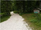 2
2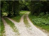 3
3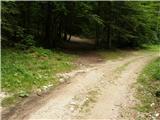 4
4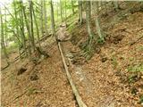 5
5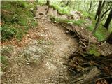 6
6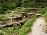 7
7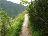 8
8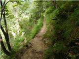 9
9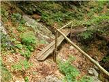 10
10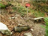 11
11 12
12 13
13 14
14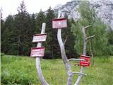 15
15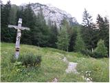 16
16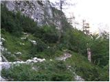 17
17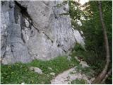 18
18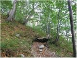 19
19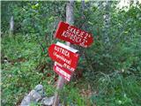 20
20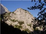 21
21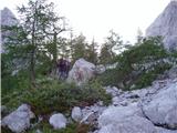 22
22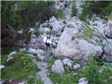 23
23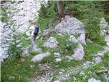 24
24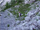 25
25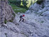 26
26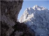 27
27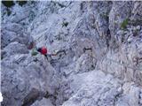 28
28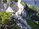 29
29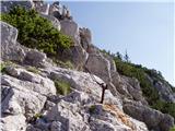 30
30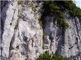 31
31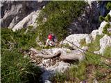 32
32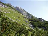 33
33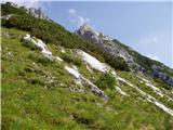 34
34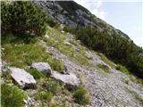 35
35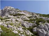 36
36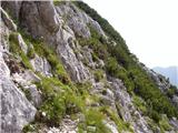 37
37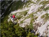 38
38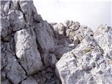 39
39 40
40
Discussion about the trail Dom Planincev v Logarski dolini - Krofička (hunting path)
|
| Stamp18. 07. 2014 |
Može prijedlog ? Po ovoj Lovskoj poti gore do Krofičke, a onda po Markiranoj stazi dolje ili je bolje obrnuto ? Hvala..
|
|
|
|
| garmont18. 07. 2014 |
Tako je bolje. Lovska je v sestopu precej bolj zahtevna kot markirana.
|
|
|
|
| franca18. 07. 2014 |
Bolje najprej po lovski, ker je navzgor lažje iskati prehode, dol pa sproščeno po markirani.
|
|
|
|
| Stamp18. 07. 2014 |
Hvala.. Malo se bojim da li bude mi društvo Lovsku uopće moglo proći.. Jesu svi mladi i fit muži, ali nemaju iskustva sa sajlama.. Neznam, možda za prvi puta markirana i gore i dole.. 
|
|
|
|
| CarpeDiem24712. 08. 2016 |
Kdor se boji, da bi se izgubil ali zaplezal tekom uporabe LOVSKE POTI, predlagam da vpraša oskrbnika v Koči na Klemenči jami, ki mi je pokazal podrobno skico (potek) poti, kako gre do vrha. Priporočam!
|
|
|
|
| garmont13. 08. 2016 |
Ne glede na zgornji komentar, se na lovsko ne odpravljajte, če nimate izkušenj s podobnimi potmi. V ruševju Zadnjega travnika vam skica "poti" ne bo veliko pomagala. 
|
|
|
|
| suhy18. 11. 2018 |
Čeprav sva z ženo po 25 letih ponovila turo po lovski stezi, je bilo tokrat kar nekaj orientacijskih težav zadnjih 150 višinskih metrov, kjer se steza izgubi. Možici na različnih mestih kažejo, da imajo tu vsi težave, ko iščejo prehode čez rušje in strme trave. Obstaja torej več variant, kako se prebiti do vrha. Objavljena GPS sled je ena od možnih variant, ki zadnjih 10 metrov pod vrhom zaide v žleb, obrnjen proti severu, kjer si je treba nekoliko pomagati še z rokami. Vseeno čudovit izlet za ljubitelje divje narave. Priporočljiv spust je po markirani poti.
|
|
|
|
| klukec0021. 07. 2025 12:40:06 |
Pozdravljeni, na Krofičko sva se s kolegom povzpela v soboto, 19.7.2025. Zajle zaenkrat še držijo. Nekaj komentarjev: Ko zapustimo pot na Ojstrico, prečimo pobočje in pridemo do grape na sliki 26. Pot se do tu še kar dobro vidi. Na vrhu te grape je na levo žleb in na desni izgleda, kot da se ta grapa nadaljuje. To ni naša pot. Naša pot gre desno prečno na to grapo. Na desni se lepo vidi klin, ki izdaja, kje je pot. Klin je prikazan na sliki 27. Pot po grebenu je kar izpostavljena, na ključnih mestih je zajla. Ta nam je tudi v pomoč pri iskanju poti. Greben nas vodi do skalnega skoka, prikazanega na sliki 31. Slika temu delu ne dela pravice. Pred tem skalnim skokom je namreč nekajmetrski grebenček s prepadom levo in desno, vstop v ta kaminček v tem skalnem skoku pa je nad prepadom. Skalni skok premagamo s pomočjo zajle. Ni ravno trivialno. O tem, kaj pomeni zdrs, ne bom izgubljal besed. Ko premagamo ta skalni skok, pridemo na idiličen travnik. Predlagam, da se usedete v travo in malo občudujete razgled. Iz tega travnika se lepo vidi vrh Krofičke in prehodi med ruševjem. Midva sva si na tem mestu vizualizirala pot. Predvsem zadnje pobočje. Ko se pride pod vrh, se gre naravnost gor. Ne vem, ampak jaz bi rekel, da gre tu za plezanje 2. stopnje. Poleg samega plezanje je potrebno iskati tudi najbolj enostavno varianto. In če izberite slabo, to lahko pomeni tudi plezanje 3. stopnje. Slaba izbira lahko pomeni tudi plezanje dol in iskanje nove poti. Orientacija je zahtevna, ker se zaradi ruševnja nič ne vidi. Midva sva preštudirala smer na travniku, kjer se je lepo videlo prehode med ruševjem, tako da se nisva izgubila. Ta del se meni zdi kar zahteven, ker napak si tu ne smemo privoščiti. Ko pridemo iz ruševja ven, vodi neka slabše vidljiva pot na desno ponovno v ruševje. Pot vodi skozi ruševje ob steni in nas pripelje do grape tik pod vrhom. Ta grapa je polna grušča in izjemno nevarna za zdrs. Na drugi strani grape je sicer skala, ampak jaz si nisem upal prečiti te grape po grušču. Če bi zdrsnil, bi namreč končal v prepadu. Po grapi sva se midva povzpela s pomočjo njenega levega roba, kjer se je našlo oprimke. Opis poti sicer ne navaja poti po tej grapi, ampak pot direktno navzgor. Mogoče je to boljša varianta, ker ta pot skozi to grušča polno grapo je res nevarna. Naju je zavedla vidna potka. Iz grape se povzpnemo še nekaj metrov po solidni skali do vrha. Na levi je sicer še ena grapa, ki vodi direktno na vrh. Upam, da ne bo kdo poskušal po tej grapi na vrh, ker je tudi polna grušča. Jaz bi to pot označil kot zelo zahtevno. Verjamem, da nekemu izkušenemu gorniku taka pot ne predstavlja nobenega problema, ampak mogoče je opis te poti malo preskromen 
|
|
|