Breginj - Brezje / Montemaggiore (via Plazovi)
Starting point: Breginj (550 m)
| Lat/Lon: | 46,262°N 13,4259°E |
| |
Name of path: via Plazovi
Time of walking: 3 h
Difficulty: easy marked way
Altitude difference: 269 m
Altitude difference po putu: 269 m
Map: Julijske Alpe - zahodni del 1:50.000
Recommended equipment (summer):
Recommended equipment (winter):
Views: 2.590
 | 1 person likes this post |
Access to the starting point:
First, drive to the Kobarid centre, then continue to the Robič border crossing. Near the village of Staro selo, leave the main road leading to the Robič border crossing and turn right towards Breginj. Follow the main ascending road to Breginj, where you park in the parking lot near the church.
Path description:
Breginj - Plazi - Brezje
Easy mountain trail. A simpler version of the traditional hike from Breginj to Brezje, which takes place every last weekend in September.
WALKING TIME: 3 hours
REQUIREMENT: Easy marked trail
Along the way: the Bela brook with its typical "šperami" barriers, the restored Patrin sawmill, the Čadonov studenček drinking water spring, the memorial to the fallen in WWII in Plaze, the Bela and Črni brooks (later merging to form the Nadiža river).
DESCRIPTION OF THE ROUTE:
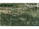
From the parking lot in Breginj, follow the asphalt road to the right in the direction of Stol and Muzco. The road first climbs through the village, and we follow it in the familiar direction at the crossroads. Higher up, the road loses its asphalt coating and leads us past an old restored sawmill (Patrin's sawmill) to a marked crossroads, where we continue slightly to the right (to the left, the Church of Our Lady of the Snows). The road, which continues to climb moderately, soon leads us to a marked crossroads, where a marked footpath to Musc branches off to the left. We take the above-mentioned path, which continues to climb moderately through the woods. Next, the path leads to a small spring (a spring with drinking water - Čadonov studenček), then turns slightly to the left and starts to climb steeply. Higher up, the path is laid and leads to a small crossroads where we continue straight on (left path for Musc). In the Plaze, a very interesting area with many streams, waterfalls, springs and the marshes that probably gave the area its name, you can stop at the World War II memorial. Here you continue along a forest road, which is also a circular cycle path. Then go through the forest, reach the crossroads for Nizki vrh, continue straight on, cross the state border leading here and soon cross first the Črni and then the Beli potok (White Stream). It is wonderful to stop at the White Stream (you can immediately see where its name comes from), where you can see a small waterfall a little higher up and continue along the forest path, which soon leads to the village of Brezje on the Italian side, where you can see the village rebuilt after the 1976 earthquake. We need to arrange transport back to Breginj or return on foot.

Pictures:
 1
1
Discussion about the trail Breginj - Brezje / Montemaggiore (via Plazovi)
|
| zane16. 04. 2025 17:47:10 |
Pred časom smo bili z družino na tej poti in sicer do Belega potoka. Je res lepa in razgibana pot, polna vodnih virov, in povsem neobljudena, srečali smo vsega skupaj 5 ljudi. Kljub temu pa je pot zelo dobro označena. Se pa kar nekaj višinskih metrov spustite proti Črnemu in Belemu potoku. Hodili smo slabih 5 ur v obe smeri, naredili smo pa preko 15 km. Priporočam za vse, ki ne marate gneče in imate radi še tisto pristno naravo.
|
|
|