Poldov rovt (Vrata) - Veliki Oltar (via bivouac)
Starting point: Poldov rovt (Vrata) (941 m)
| Latitude/Longitude: | 46,4216°N 13,86289°E |
| |
Route name: via bivouac
Walking time: 6 h
Difficulty: very difficult pathless terrain
Elevation gain: 1680 m
Elevation difference along the route: 1680 m
Map: Tiglav 1:25.000
Recommended equipment (summer): helmet
Recommended equipment (winter): helmet, ice axe, crampons
Views: 63.575
 | 10 people like this post |
Access to starting point:
We drive to Mojstrana, and then we follow the signs for the Vrata valley. Further, we drive through the Vrata valley, about 100 meters before the road sign 10 km, we will notice a cart track which branches off to the right perpendicularly to the main road. Here is the beginning of the described path. The marked parking lot where parking is allowed is situated approximately 500 meters ahead on the main road.
Route description:
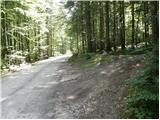
We go on a cart track which runs into the forest and then past a smaller house, where we continue slightly to the left on a footpath. Through the forest, we are ascending slightly to the left towards the stream Rdeči potok. A little before the stream, the path over Brinje branches off to the right (placed cairn, and on the tree is carved some kind of face and letter L). The path then brings us to the riverbed of the stream. Here the path goes on the right side (left bank) upwards and then soon crosses the stream to the left side. The path ascends through a small valley until a smaller wall blocks our path, where we usually also encounter a spring. The path goes from here to the right and steeply ascends through a natural passage. Slightly exposed and not secured. We are above a small waterfall (if there is water). Here we come out of the forest and ascend over some scree. The path over the scree isn't comfortable because storms and avalanches every year destroy the path. The path soon turns slightly to the right and for a short time ascends on a grassy slope. Next follows again the ascent beside scree fields and soon we come to the bivouac na Jezerih, which we will notice on our left. Here we can sleep overnight or just take shelter in case of a storm. Here the terrain flattens. The view of Triglav is from here very beautiful.
The path from here onwards slowly disappears but we can still follow it. We walk on a meadow named Na Jezerih (supposedly there used to be a lake here). The path here turns slightly to the right. Straight ahead of us we see Dovški Križ. Our path goes into the wall somewhat to the left of Dovški Križ. We look for the path that goes into the steep slopes. The path is not hard to find since cairns are placed along the path. Here the path becomes quite demanding. First we steeply ascend a rocky slope, then follows an exposed crossing to the left without any fixed protections. In wet conditions, there is a great risk of slipping. When we overcome this rocky step we arrive at the ridge. Here we go left and descend slightly to the saddle Grlo. We arrive at the scree below Oltar, where we begin to ascend. We spot a distinct gully (straight ahead) and head towards it. We follow the cairns, which direct us slightly to the left of the gully. The slope becomes steeper and steeper and also slightly crumbly. Towards the summit we head right again, reaching the main ridge directly above the notch. Here we continue a few meters along the northern side of the ridge, then ascend back onto the ridge. Only a few more meters of walking along the exposed ridge remain to the summit.
Ascent to Oltar is very demanding pathless terrain with climbing up to 2nd grade. The use of protection is highly recommended.
Despite numerous cairns that help us find easier passages, orientation remains demanding.

Photos:
 1
1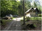 2
2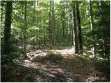 3
3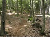 4
4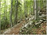 5
5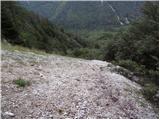 6
6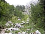 7
7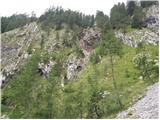 8
8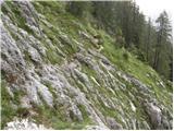 9
9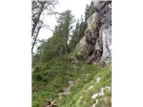 10
10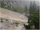 11
11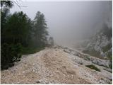 12
12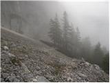 13
13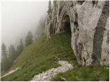 14
14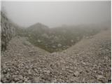 15
15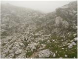 16
16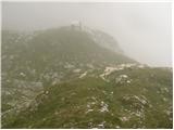 17
17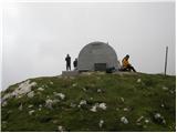 18
18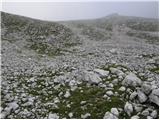 19
19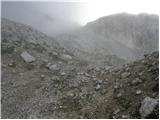 20
20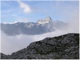 21
21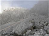 22
22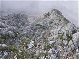 23
23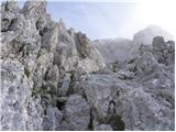 24
24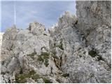 25
25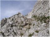 26
26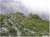 27
27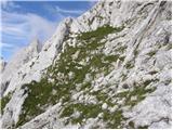 28
28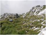 29
29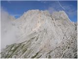 30
30 31
31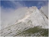 32
32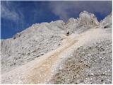 33
33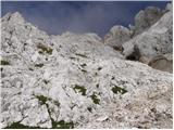 34
34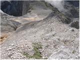 35
35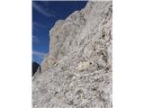 36
36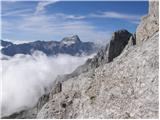 37
37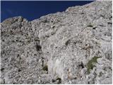 38
38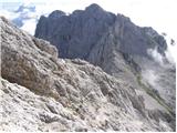 39
39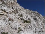 40
40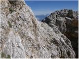 41
41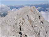 42
42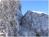 43
43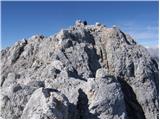 44
44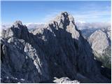 45
45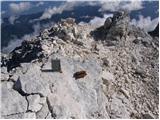 46
46
Discussion about the trip Poldov rovt (Vrata) - Veliki Oltar (via bivouac)
|
| JusAvgustin7. 10. 2009 |
Super tour, it can be continued with ascent to Dovški križ and by the way to Šplevta. M. Matterhorn is sort of along the path. Views I can't describe, wilderness, untouchedness, few people, solitude, primality. I recommend overnight in bivouac II, then at dawn to Oltar. You won't regret it. Back via the longest scree!
|
|
|
|
| zabica26. 07. 2010 |
Hi geolog79! Since it's an unmarked path I'm interested in how orientation is? I know people who went up several times before they managed to find the summit. Do you have perhaps some useful tip or advice?
Thanks, LP
|
|
|
|
| JusAvgustin27. 07. 2010 |
from the bivouac onwards cairns, sometimes hard to see, first target is the gully, once in the gully descend down along the slope, look for the torrent gully on the right side, up along the gully to the large rock slab (with a peg in it). Bypass the slab on the right, reach the chimney, up the chimney and along the ridge to the summit...
|
|
|
|
| JusAvgustin29. 07. 2010 |
Yesterday climbed to V. Oltar. Starting point in Poldov rovt, then through the bushes to the saddle, from the saddle to Grlo, from Grlo to the summit. Cairns along the "path" indicate the direction where and how... Slab before the summit, bypass on the right past the exposed crossing, into the chimney from the chimney to the ridge. The most beautiful (one of ) mountain we have. No snow anywhere to cross, scrambling up to grade II, crumbly and partially exposed. ) mountain we have. No snow anywhere to cross, scrambling up to grade II, crumbly and partially exposed.
|
|
|
|
| ponosen23. 09. 2010 |
today slipped on Oltar... it's quite demanding.. everything crumbles, stones fly... but worth it for the magnificent views.. (until tomorrow afternoon then probably end for this year 
|
|
|
|
| JusAvgustin23. 09. 2010 |
Congratulations! did you find the summit right away, or did you get lost like many? climbing nowhere exceeds II degree (and even that is the slab under the summit, where there is a bypass), you were probably alone today in those areas... magnificent feeling, right? that it's only until tomorrow morning is in my opinion too hasty a statement.  October is coming, after October November and I hope white December. October is coming, after October November and I hope white December.
Lpp, Juš
|
|
|
|
| ponosen24. 09. 2010 |
thanks, thanks.. you already know from the bivouac, when I went right, then I didn't know how to proceed, whether towards Dovški križ or into the "throat", then I saw a group of hikers returning from the summit and as they descended into the throat it was immediately clear to me. Yes, at that slab before the summit, I bypassed it to the right then you have less than 10m left to the summit, but I found an easier way to the summit for me, less exposed, a bit lower bypassing that described path. On the way back, I descended right at that slab and got tangled several times. Oltar is very dangerous! Well, given how crumbly and unmarked Oltar is, it should have its own category... and not just II degree. (that day it was me and the already mentioned group of 5 hikers, judging by the logbook, there were only about 50 people all summer) For this summer season I thought, probably without crampons and ice axe from today Oltar is inaccessible until next summer (we'll see) Now Rokavi tempt me, which along with V. Ponca is the only unconquered 2600er for me in the Julian Alps. I'll send some photos of that day...
|
|
|
|
| JusAvgustin24. 09. 2010 |
Be careful with the Rokavi, they are a grade harder than the Altar, speaking from personal experiencehttp://www.hribi.net/trenutnerazmere.asp?slo=1&gorovjeid=1&id=2791, unlike VO, on the Rokavi belaying is recommended, if not mandatory, plenty of pegs, stances are equipped, but without at least basic alpinistic knowledge don't go up there, especially not alone... but it's nice on the Altar, right? Do you agree it's one of the nicer peaks we have? Oh, and one more thing: the Altar is "just" a II, the "easiest" Martuljek giant. The other Martuljek spires are a grade or two harder...
|
|
|
|
| turbo25. 09. 2010 |
Yes, geolog79, you're right. Proud one, don't go to the Rokavi without at least some alpinistic knowledge and without proper gear (which you must know how to use).
Visoki Rokav is an ascent with sections of III difficulty, the other two are somewhat easier but by no means easy.
A few years ago, my buddy and I climbed to the II in the afternoon, bivouacked, then early morning into the Rokavski ozebnik and then right to Visoki Rokav, after that to Srednji. On descent from Visoki we abseiled twice by rope ("stances" made and equipped). Glacier icy, hard, crampons and ice axe mandatory.
With Spodnji Rokav we did it from Kotli (marked to Škrlatica to the ridge, then down to Kotli and on to Rokav).
Nothing to it, Rokavi are top-notch.
|
|
|
|
| JusAvgustin25. 09. 2010 |
but what Rokavi, the whole Martuljek group is TOP!!!!!!!!!!!!!!!!!!!!!!!!!!!!!!!
|
|
|
|
| šodrovec25. 09. 2010 |
Congratulations!
But then you gave up on the idea of combining Oltar with Dovški križ?
|
|
|
|
| JusAvgustin25. 09. 2010 |
and also to Šplevta on the side, and to Mali Materhorn... great tour, especially because from Dovški križ you get a magnificent view of Široka peč, which with its towers looks like... well, nothing to it, our mountains are something magnificent!
link to the above described tour: http://www.hribi.net/trenutnerazmere.asp?slo=1&gorovjeid=1&id=2147
it's a great pleasure and satisfaction to share my exploits with you forum folks, especially in this weather...
|
|
|
|
| šodrovec25. 09. 2010 |
I mean you, geolog79, of course.
I was asking the young guy nicknamed "ponosen", who late morning, already a bit above Vrata, had Dovški križ also in his plans.
|
|
|
|
| JusAvgustin25. 09. 2010 |
Aha, I didn't know that, if he started early it would have worked, from VO to DK is a good hour's walk... yeah I know, but I was surprised by the other info that there were 50 people on VO this year! When I was on ŠP, the logbook there from 1998, we signed as 243 and 244. A bit of math: about 20 people per year. On Oltar I'd expect some more. Anyway, better it stays like that, on Rokavi the book is more or less similar to ŠP.
Lpp
|
|
|
|
| ponosen25. 09. 2010 |
Šodrovec hello,
yes exactly like that.. searching for the little men takes too much time, and you get dizzy quickly. So where did you two head off to afterwards?
|
|
|
|
| šodrovec25. 09. 2010 |
Ouch. I thought it would be like that, but I didn't want to discourage you beforehand. Still, you did the first steps in that world quite well. With Rokavi and such, just be careful, you have time. You already have one shirt with sleeves anyway - I saw it with my own eyes. Congrats again!
We two walked across both Črlovca to Njivice under Vrtaški vrh, then to Vrtaška planina and back via hunter's path above Peričnik to the car. Beautiful paths. Nice, even without summits conquered.
|
|
|
|
| ljubitelj gora24. 06. 2012 |
The path is dry, loose terrain, caution, but exceptional views from the top.
|
|
|
|
| Žiga222. 08. 2012 |
Hi!
Would it be possible to slightly change the trail description to avoid misunderstandings in the future; my colleague and I went to V. Oltar today and got a bit lost above Grlo (judging by the footprints and trodden path, we weren't the first to stray). The cairns from the scree above Grlo are quite poorly visible, in my opinion the following addition would greatly help future wanderers:
"From the scree, two gullies lead off, for the ascent to V. Oltar we must take the left one and follow it to the massive stone arch. There, further cairns are already visible on the left."
If you miss it and go up the right one (like we did), you're in for quite some unpleasant scrambling to the top of the ridge and then an even more unpleasant descent into the notch mentioned in the description and ascent on the north side to the V. Oltar ridge.
Best regards
|
|
|
|
| andrejp10. 09. 2012 |
Really nice tour that we did yesterday. Sunny day and fantastic views. Considering all four of us were first-timers, we found the path quite well, added a small stone to the existing cairns and enjoyed the climbing. I also think the path description could be changed so it's clear that there are two gullies towards the summit and that you follow the left one on the left side.
It was a pleasure
Best regards A
|
|
|
|
| B.Smart25. 09. 2013 |
Matej. None of the albums open for me, even though I have my own profile on Picasa...
|
|
|
|
| alpski svizec17. 07. 2016 |
Following the cairns and your instructions to the far left to the summit without problems. Dry.
|
|
|
|
| metod28. 08. 2016 |
Yesterday there were very few hikers above Bivak II (which is currently not there as it is being replaced). There are plenty of cairns to the top of V. Oltar (thanks for placing them ). Without them I would have wandered freely and perhaps not reached the top. The spring towards Bivak II is buried, for water you have to go a few meters lower, where it is more exposed.
|
|
|
|
| barbara.hribi20. 07. 2017 |
Hello, I'm interested if the bivouac at Jezerih (bivouac II) is now set up for overnighting and if from there it's still approx. 2 hours to the top of V. Oltar? Since this year there's no comment here yet and I'm curious about the conditions if anyone has been up this year?
|
|
|
|
| toti29. 07. 2017 |
I would point out an error in the access description to the starting point, where it says the cart track with the signpost is BEHIND the 10km marker, in reality it is about 100m BEFORE that marker. And thanks to Žiga22 and andrejp for the notes on the correct gully!
|
|
|
|
| Stef_Smi21. 05. 2022 17:19:55 |
Don't forget that until 3.6.2022 (weekdays) from 07:30 to 18:00 there is a complete road closure:
link
|
|
|
To post a comment you must log in:
If you do not yet have a username, you must first
register.