| katty18. 08. 2013 09:29:43 |
A tip from a Facebook friend convinces us to tackle our first three-thousander. Judging by the pictures, a really wonderful and fairly easy summit was ahead of us, which is actually the highest in the area.
Since the approaches to the parking were poorly described, finding this starting point was already quite a small adventure... haha, but it ended happily anyway. This Debanttal valley is quite wonderful and along with some others on the other side of the pass belongs to Hohe Tauern National Park. The gravel path winds along a pleasant stream, which is very welcome on the way back to the valley :-). The entire path is nicely arranged and only occasionally rises a bit steeper. On the right side to the parking you can observe some private holiday huts, all of alpine style of course....
First look at the parking lot is shocking... first you wonder and ask yourself what the heck, do all these really drive up there, then you start thinking where to park the car :-o, as everything was fully occupied.... Well anyway, no problem, something will be found. This parking spot is at 1368 m, so if we think well, almost 2000 m of elevation gain awaits us... oh international, that's not so bad... Well, full of enthusiasm and desire for new adventures we quickly started puffing up the hill... The stream we crossed was quite soothing, the fog that was always somewhere above us a bit scary... but nothing bad, as we experienced a bit later when going up to the pass. We followed mark 393 leading to Wangenitzsee hut. Along the path, partly through spruce forest, we also looked a bit for mushrooms – found some, but on the way back they weren't waiting anymore, a bit higher up we picked some strawberries and blueberries, so there was some sweetness too. The path rises slowly and steadily in hairpins, bringing us to Pußnigalm alpine pasture, where quite flat, cute and diligent cows awaited us. We made a short pause there, looking for sunshine but didn't find it, so we went on fairly quickly. After walking for some time we weren't quite sure if on the right path, so we asked passersby if the path is correct. Well, a bit higher there were signs waiting for us, so we knew we didn't get completely lost. Hehehe... Here the path levels a bit again, then to the saddle it rises steeply a few times... otherwise no problem at all, but this fog gave us trouble... we were dizzy the whole way, so we ascended quite slowly. The scree just below the saddle is a bit tricky, ok for up, for down exactly such for some fall. Safely at the saddle we breathed more concretely and drank something, then limped on... A bit lower down we saw lakes... left Kreuzsee-2483 m, the one directly under hut Wangenitzsee-2465 m, into which the left lake also drains. Fog swirling all around didn't allow any views, and all summits wrapped in it, so we were a bit sad as we didn't even know what we were doing. To the hut we did 1140 m, from there to summit another 780 m. Hospitality in hut and good tasty food keep us inside. Finally we decided to look at lake surroundings. Flora here due to different conditions and rocks differs quite from ours, so no edelweiss or gentians, no marmots at all. Anyway on return to hut we noticed some folks coming back from our summit... By info we got, nice path awaited us which we were really looking forward to.
Morning that woke us was quite wonderful... Golden colored rocks, blue sparkling lower lake, fresh morning, cloudless sky... fairy tale or fantasy as Monika usually says... So besides overnight we had breakfast included which waited quickly for us. We hurried and slowly set off towards summit. At about three places chains 8-10 m long awaited us for safe passage. Sheep voices accompanied us all time... Well, sometimes it takes long to figure out where the sheep are... and they really are on every possible grassy ledge even if abyss below. Grassy, partly quite scree path brings us to first snowfield. Up again quite flat, down not, as our steps melted quickly making normal "path" into slide... grrrrrr, irresponsibility :-(.... Again through scree, slowly up to 3000 m. In moderate pace we reached wide panoramic ridge where view to our summit opened. Another cca. 20 min walk and bit of snow to cross, then another 100 m up and that's it. Summit sometimes in fog was incredibly visited on Friday. Actually not strange, as it offers really wonderful view to near and far summits, Grossglockner in front.... We saw it just for a second, as fog persistent covering it quite a bit. Pity. So of course on our first 3-thousander we could photo several times, and sign the book which reveals my compatriots don't come here too regularly. On summit we stayed about an hour, looked around a bit  , then slowly headed back to hut. On that scree we had to be quite careful, but it went. So we had wonderful view whole way to surrounding hills and summits where no visitors seen... only crosses. Chamois, quite a few here I think, skillfully avoided us so we saw none... but heard them... Again we met a family around 14 h heading to summit. When we told them there's still some snow up and surely 2.5 h to summit, they probably decided higher up not to continue ascent. Well, given footwear smart decision. We took another pause on grassy ledge, then after 2.5 h approached hut where rest of stuff waited. First we took another pause, then quickly to start point. , then slowly headed back to hut. On that scree we had to be quite careful, but it went. So we had wonderful view whole way to surrounding hills and summits where no visitors seen... only crosses. Chamois, quite a few here I think, skillfully avoided us so we saw none... but heard them... Again we met a family around 14 h heading to summit. When we told them there's still some snow up and surely 2.5 h to summit, they probably decided higher up not to continue ascent. Well, given footwear smart decision. We took another pause on grassy ledge, then after 2.5 h approached hut where rest of stuff waited. First we took another pause, then quickly to start point.
This Petzeck made nice impression on each of us. We decided to return sometime, lots more to visit here... Debanttal valley, we'll visit you again!
") 1 1") 2 2") 3 3") 4 4 5 5 6 6 7 7 8 8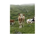 9 9") 10 10 11 11 12 12 13 13 14 14 15 15 16 16 17 17 18 18 19 19 20 20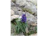 21 21 22 22 23 23 24 24") 25 25 26 26 27 27 28 28 29 29 30 30 31 31 32 32 33 33 34 34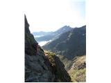 35 35 36 36 37 37
|
|