Ojstrica, Lučka Brana, Planjava and Brana
|
| Guest2. 08. 2010 17:23:52 |
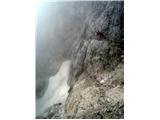
Yesterday morning we parked one car under Rinka waterfall, the other at Dom planincev, where we were a bit late at 3:10 AM and started the planned tour. During the hike we realized we have different paces, so there was an agreement to go to Ojstrica each on our own, since we planned to watch the sunrise around 6:30 AM. So David and I huffed up to the summit after a good 2h, where we observed one of the nicer sunrises. On the way further towards Planjava, chamois kept us company in the morning calm. Meanwhile the mates behind us called us and said they had to turn around a bit below Ojstrica summit due to troubles and descend back to the valley. From Planjava onwards the Sunday crowds started. From Brana it was nice to see how very visited all KSA peaks were. No wonder, when it was such a nice day. In short, another unforgettable day spent in the mountains.
Best regards from under the beautiful Mozirska planina, Janez.
|
|
|
|
| Sorok5. 07. 2015 15:02:38 |
So not to open new topic, I'll attach to this one, although my tour yesterday was: from Logarska valley from pension Na razpotju, Klemenča jama, Lučka Brana (Baba), Planjava and back same path.
Weather suitable, enough cloudy with light wind that helped ease the heat  Path BP, although you need to cross two small snow patches, which are passable BP. Met quite some hikers, with some met even multiple times and nicely chatted. If they read this, greet them all nicely and hope to meet again Path BP, although you need to cross two small snow patches, which are passable BP. Met quite some hikers, with some met even multiple times and nicely chatted. If they read this, greet them all nicely and hope to meet again
 1 1 2 2 3 3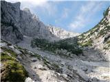 4 4 5 5 6 6 7 7 8 8 9 9 10 10") 11 11)") 12 12 13 13 14 14 15 15 16 16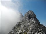 17 17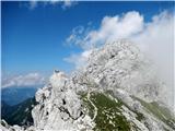 18 18 19 19 20 20
| (+5) |  | |
|
|
|
|
| Stane76. 07. 2015 20:48:23 |
 1 1
| (+3) | | |
|
|
|
|
| Sorok6. 07. 2015 21:17:29 |
Hi Stane! Nice photos! Probably slept well after these tours despite the heat See ya LP! See ya LP!
| (+1) | | |
|
|
|
|
| jasminka6. 07. 2015 21:43:27 |
Beautiful tour, gorgeous pictures!!!
|
|
|
|
| Stane77. 07. 2015 19:30:08 |
Thanks to both. I sleep much better after finishing the tour than before it.
| (+1) | | |
|
|
|
|
| planika8225. 07. 2015 14:15:58 |
I'm wondering how long the path from Ojstrica summit takes, descent over Škarje and then continuation to Planjava and then to Kamniško sedlo?
Thanks for the answer.
|
|
|
|
| otiv25. 07. 2015 14:26:34 |
You get there in 3 hours with normal hiking.
| (+3) | | |
|
|
|
|
| lijaneja10. 10. 2020 08:21:25 |
Polona, you were on Lučka Brana. In picture 6 it's the pre-summit of the eastern Vile.
| (+1) | | |
|
|
|
|
| ppegan10. 10. 2020 08:41:48 |
Tone, really??? Because according to the description of Lučka Brana, I'd say I was on the right summit, but according to the summit pics no, because it looks more dome-like and spacious, which this one wasn't 
|
|
|
|
| zokipoki10. 10. 2020 08:52:14 |
Lučka Brana is the first summit from Škarije to the west, photo 8 as far as I know, so you were on the summit. The rockfall/break on the north side is clearly visible from in front of the shelter. From the marked path to the summit leads a short unmarked section. If I'm wrong, someone correct me.
| (+1) | | |
|
|
|
|
| ppegan10. 10. 2020 09:16:06 |
Zoran, if that's really true what you wrote, then I really was on the right summit, on the first summit west of Škarije. Yay, I'm so happy now Thanks to both of you
| (+2) | | |
|
|
|
|
| zokipoki10. 10. 2020 13:55:05 |
Polona, even if it's not correct, summit up or down , it's important that you had a good time. Best regards
| (+1) | | |
|
|
|
|
| ppegan10. 10. 2020 14:57:41 |
Zoran, I sign under your comment Because Baba was on my wish list for loooong, I'm glad I made it, despite the initial wrong belief 
|
|
|
|
| JTrogar10. 10. 2020 16:31:24 |
Tone and Zoran are both wrong. This can't possibly be the eastern fore-summit of Viliči nor Lučka Baba but its fore-summit. Height difference between Lučka Baba and Viliči is only 6 meters, that spire next to Škarije on pic 8 is cca 100m lower than Lučka Baba. Polona, you'll have to go again. I'll add some pics to clarify.
Best regards and safe steps from under beautiful Golte, Janez
| (+1) | | |
|
|
|
|
| lijaneja10. 10. 2020 16:53:20 |
Janez, you'll have to go first, just hurry, tomorrow there'll already be snow so you see your mistake. Lučka Brana is 2244m high, eastern summit of Viliči 2335. Between them intermediate unnamed summit just a few meters lower than Viliči.
Hurry, clouds gathering around Planjava!
|
|
|
|
| ppegan10. 10. 2020 17:17:52 |
Well, now I'm really confused Anyway, I'll go up 1 more time and over all summits so no more debates Of course next year or snow-free, for this year probably say goodbye to such two-thousanders 
| (+1) | | |
|
|
|
You must log in to post a comment:
If you do not yet have a username, you must first
register.