Rifugio Auronzo - Rifugio Locatelli
Starting point: Rifugio Auronzo (2320 m)
| Latitude/Longitude: | 46,6122°N 12,2941°E |
| |
Walking time: 50 min
Difficulty: easy marked way
Elevation gain: 85 m
Elevation difference along the route: 135 m
Map: Tabacco 10 1:25.000
Recommended equipment (summer):
Recommended equipment (winter):
Views: 19.270
 | 2 people like this post |
Access to starting point:
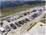
Access from Gorenjska: Through the Rateče border crossing we drive to Trbiž / Tarvisio, where we head onto the highway in the direction of Udine / Videm. We leave the highway at the Tolmezzo exit and follow the road to the mentioned settlement. From Tolmezzo we continue in the direction of the settlement Ampezzo and mountain pass Passo della Mauria. The road then starts descending and brings us into the Cadore valley, where we continue right (left Belluno and Cortina d'Ampezzo) in the direction of the settlement Auronzo. After a few additional km of driving we come to the next major crossroad, where we turn right in the direction of Austria and Tre Cime (left Cortina d'Ampezzo). We leave the road towards Austria after another few 100 m, because signs for Tre Cime direct us right onto a toll mountain road which after 7 km brings us to a large parking lot near the mountain hut rifugio Auronzo.
From Primorska side: We drive on the highway which leads through the Sežana border crossing to Trst / Trieste. Further we drive on the Italian highway in the direction of Padova, but only to the highway junction, where we continue in the direction of Veneto and Belluno. Near Belluno the highway ends, and we continue in the direction of Cortina d'Ampezzo and Auronzo. When the road brings us into the Cadore valley we come to a major crossroad, where the road towards Cortina d'Ampezzo goes left, towards Auronzo right. Here we continue right towards Auronzo. Further we follow the above description.
Route description:
At the mountain hut Auronzo we head onto the macadam road which leads towards the mountain hut Lavaredo slightly to the east. After approximately 20 minutes of walking on a very panoramic road which leads below the mighty walls of Tre Cime we arrive at the Lavaredo hut.
From the hut we continue slightly to the left and start to ascend the scree towards the notch (Forcella Lavaredo) between Monte Paterno and Tre Cime. At the notch where there is a path junction we take the wide path, which from the notch starts to descend slightly towards the north. To the right branches off the path which leads to Monte Paterno from the south side and path 104, which starts to descend towards the east. During the descent towards the Locatelli hut we can choose the lower wide path or the upper somewhat more difficult one, which crosses the slopes below the western wall of Monte Paterno. At the hut from where there is a very nice view of Monte Paterno and Tre Cime both paths join again.

Photos:
 1
1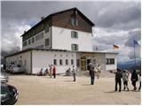 2
2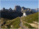 3
3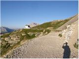 4
4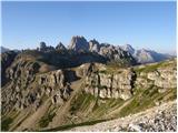 5
5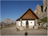 6
6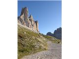 7
7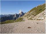 8
8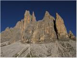 9
9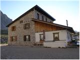 10
10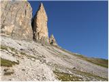 11
11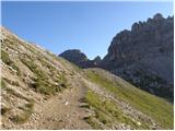 12
12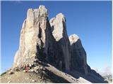 13
13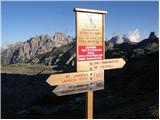 14
14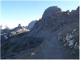 15
15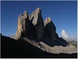 16
16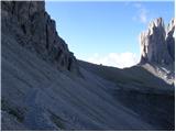 17
17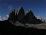 18
18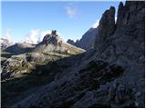 19
19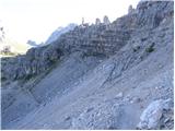 20
20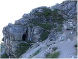 21
21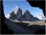 22
22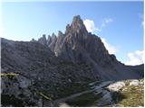 23
23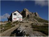 24
24
Discussion about the trip Rifugio Auronzo - Rifugio Locatelli
|
| robi1429. 07. 2014 |
I'm wondering if the path from Rifugio Auronzo past Rifugio Lavaredo to Rifugio Locatelli is passable with a stroller?
When I look at Google Earth pictures, there are actually gravel paths around and between these huts. How wide are they?
What about the circular path?
Otherwise we'll go with a backpack, but it would probably be much more comfortable for the little one in the stroller...
The stroller is a bit more "rugged" with larger wheels.
Thanks for the answers,
Robi
|
|
|
|
| Rok30. 07. 2014 |
The path to Rifugio Locatelli is wide and gentle, so it should be possible even with a stroller.
The circular path around the Tre Cime I think is not suitable for a stroller. Part of that path can be seen here.
|
|
|
|
| dprapr30. 07. 2014 |
On the 9th picture, among others, the wall of Punta di Fride dominates...
|
|
|
|
| mišel5331. 07. 2014 |
Walked the mentioned path 2x and I think that already to Rifugio Locatelli on some sections it would be a problem for a stroller. For the circular path
around the Tre Cime, better go with a backpack, although it does drag a bit.
|
|
|
|
| robi1431. 07. 2014 |
Thanks for the answers @rok and @mišel53.
So, backpack and a few more stops and eye candy... 
|
|
|
|
| Rok31. 07. 2014 |
On this picture you can see what kind of vehicles can reach the Rifugio Locatelli. However, the regular hiking path has some shortcuts, which are not as wide.
|
|
|
To post a comment you must log in:
If you do not yet have a username, you must first
register.