Javorje - Šija (via Zadnja Suha)
Starting point: Javorje (1050 m)
| Lat/Lon: | 46,2496°N 13,8675°E |
| |
Name of path: via Zadnja Suha
Time of walking: 2 h 30 min
Difficulty: easy marked way
Altitude difference: 830 m
Altitude difference po putu: 900 m
Map: TNP 1:50.000
Recommended equipment (summer):
Recommended equipment (winter): ice axe, crampons
Views: 10.844
 | 1 person likes this post |
Access to the starting point:
From the Ljubljana - Jesenice motorway, take the Lesce exit and follow the road towards Bled and on to Bohinjska Bistrica and Lake Bohinj. After Laški Rovt you will reach a small crossroads where the road to the left branches off and leads to the starting points of the route to Rodica, mountain pasture Suho, Šijo, Vogel. . . and the Laški Rovt camping area. The dirt road immediately turns into a forest and first climbs past the above-mentioned camping area and then climbs relatively steeply for a few kilometres. After a little less than 6,5 km of macadam, you will reach a slightly larger crossroads where the road to the right branches off towards mountain pasture Storeča raven (the starting point of the route to Vogel). Continue straight on here and after about 50 m of further driving you will reach a left turn where the starting point of the route towards mountain pasture Suha. Park in a suitable place on the roadside.
Path description:
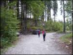
Near the parking lot, on the west side of the torrent, there is a marked footpath leading to mountain pasture Suha. The path initially climbs up the right-hand side of the torrent before joining it. After a few steps along the torrent, the marked path turns to the right and lays completely flat. The gently sloping walk is quickly interrupted by a steep ascent over a relatively steep slope. The steepness then eases a little and the well-marked path then leads up through the dense forest along and along the torrent. A little higher up, the marked path leaves the stream to the left and rejoins it after a few minutes. The path then runs along the right side of the torrent and soon leads us out of the forest onto the vast mountain pasture of Suha.
From mountain pasture continue past the shepherd's hut along the torrent gravel deposit. The path, which is sometimes very faint, turns slightly left at the top of mountain pasture. Further on, the path, which begins to turn slightly to the right, is much easier to follow. After a short climb, pass a hunting lodge, which can be seen on the right.
The path then begins to climb steeply up the slope, which is partly covered with dwarf pines. This increasingly scenic route, however, leads us higher up to the slightly larger cairn, where there is a crossroads (straight marked path to the Čez Suho saddle, left unmarked path over Lepo Suho).
Continue straight on the marked path climbing between dwarf pines and sparse trees. Higher up, the trees run out and the path reaches a sink below the saddle Čez Suho. The path goes around it on the left and soon afterwards leads to a crossroads at the saddle Čez Suho. Here stands an old military bunker with signposts.
Here we turn right on the path in the direction of Šije (left Rodica), which leads us in a slight ascent along the ridge. Soon the path retreats from the broad ridge to the northern slopes, where it crosses a slightly exposed ravine in a downhill descent. There is a short climb on scree to a crossroads below the top of Šije.
Here, turn left onto a steep path that will take you to the top of Šija in five minutes.
Starting point - mountain pasture Suha 1:00, mountain pasture Suha - Čez Suha 1:00, Čez Suha - Šija 30 minutes.

We can extend the trip to the following destinations: Vrh Dlani
Pictures:
 1
1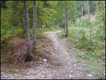 2
2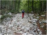 3
3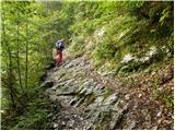 4
4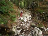 5
5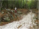 6
6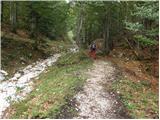 7
7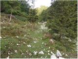 8
8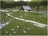 9
9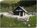 10
10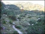 11
11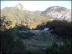 12
12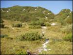 13
13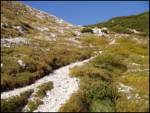 14
14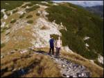 15
15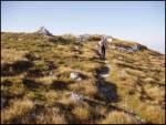 16
16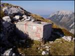 17
17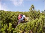 18
18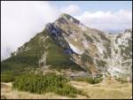 19
19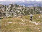 20
20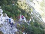 21
21 22
22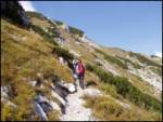 23
23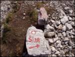 24
24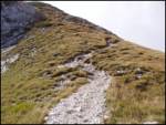 25
25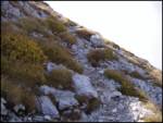 26
26 27
27
Discussion about the trail Javorje - Šija (via Zadnja Suha)
|
| tango28. 06. 2021 22:05:36 |
Prešnji teden pl. Suha, sedlo Čez Suho in do M.Raskovca, danes pa na sedlu desno, najprej na Šijo potem pa sva podaljšala še do Vogla, saj je bilo vreme odlično in niti ne preveč vroče. Se je pa v enem tednu kar močno spremenila cvetoča preproga, pobralo pa je tudi še tisto nekaj snega, tako da je pot bp.
|
|
|