Koča pri Savici - Mahavšček (via planina Govnjač)
Starting point: Koča pri Savici (653 m)
| Lat/Lon: | 46,2896°N 13,8022°E |
| |
Name of path: via planina Govnjač
Time of walking: 4 h 55 min
Difficulty: easy marked way
Altitude difference: 1355 m
Altitude difference po putu: 1500 m
Map: TNP 1:50.000
Recommended equipment (summer):
Recommended equipment (winter): ice axe, crampons
Views: 18.164
 | 2 people like this post |
Access to the starting point:
From the Ljubljana - Jesenice motorway, take the Lesce exit and follow the road towards Bled and on to Bohinjska Bistrica. Continue driving towards Bohinjsko jezero (Ribčev laz), at which you will come to a crossroads, where you will continue straight along the left (south) side of the lake in the direction of Ukanec and the Savica waterfall. Follow this increasingly narrow road to the large parking lot at the Savica cottage. There is a charge for parking.
Path description:
From the parking lot, follow the wide footpath towards the Savica waterfall and the Komna home. After a short ascent, the path leads us to a marked crossroads where the tourist path to the right branches off towards the Savica waterfall, and we continue slightly to the left or straight along the wide footpath in the direction of Komna. The path continues to climb for a short time along Savica, and then leads us to the first of the 48 marked serpentines. After an hour and a half of moderate ascent through the forest, the path leads us to the 48 serpentine from which we have a beautiful view of Lake Bohinj. Here the path turns slightly to the right and passes into the valley called Pekel, where it climbs gently for a while, then turns to the right and climbs slightly steeper again. After only a few 10 paces, the path turns left again and continues to climb parallel to the valley. The path, which is steep to moderately steep, gradually turns into a more sparse forest, from which you can soon see the house on Komna. The way forward leads us past a small man-made cave, and higher up, past a natural abyss, which is fenced off to prevent any of the hikers from falling into it. Next, the path climbs a little more and after a few steps of further walking leads us to a crossroads where the path to the right branches off to the Black Lake.
Continue straight ahead on the wide path (mulatjeri), which takes you just a little higher to the next crossroads. Continue again to the left (to the right the cottage at Triglav Lakes) along the path, which climbs a little more steeply and after a few minutes of further walking leads us to the hut at Komna.
From the house, continue left in the direction mountain pasture Govnjač, Vogel and Mahavščka (right Bogatinsko sedlo and Krn) along the path, which starts to descend more steeply shortly after the hut. The path soon becomes steeper and after 5 minutes from the house at Komna it leads to a marked crossroads, where we continue to the right in the direction of mountain pasture Govnjač. The route continues along an old military causeway and, with the exception of a few short ascents, descends. After about 30 minutes' walk from the house at Komna, you will reach the information board at the aforementioned mountain pasture.
From the information board, continue along the poorly visible path (direction Mahavšček), which leads us after a few steps to a number of ruins (the Krn battlefield during the First World War). On the other side of these ruins, you will reach the next direction sign, where you have two options for continuing. Continue straight in the direction "Mahavšček - shortcut" (slightly to the right Mahavšček, marked as a marked "shortcut" on the 1:50. 000 PZS map of the TNP) along the initially less visible path, which soon becomes more distinct and then begins to climb steeply under steep cliffs. The path, which crosses some small scree scree on the ascent, becomes higher and a low-lying path joins from the right.
The ascent is resumed on an old military dirt track, which takes us just a little higher up to a pleasant and relatively large grassy plain. In the upper part of the plain, the path turns to the right and starts to climb moderately up a small valley. Just a few steps further on, the smaller valley splits in two (here you will see cairn marking the start of the unmarked trail on Tolminski Kuk), and the marked trail continues along the edge of the right-hand valley. The path continues past some small basins and then starts to climb steeply, over an initially grassy slope. Higher up, the path crosses a small scree slope, and then, as the views get better and better, it leads to a marked crossroads.
Continue right in the direction Bogatin (left Tolminski Kuk) along the old military causeway, which crosses the slopes of Vrch Škrli. A little further on, the path leads us to the main ridge of the Lower Bohinj Mountains, and the path continues to climb quite gently for some time. Higher up, the ridge narrows slightly, and the path begins to climb steeply towards Mahavščko, the summit of which is reached after a few minutes of further walking.
Starting point - Komna 2:30, Komna - Mahavšček 2:30.

Pictures:
 1
1 2
2 3
3 4
4 5
5 6
6 7
7 8
8 9
9 10
10 11
11 12
12 13
13 14
14 15
15 16
16 17
17 18
18 19
19 20
20 21
21 22
22 23
23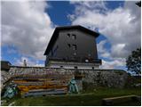 24
24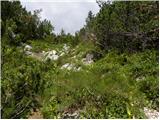 25
25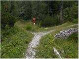 26
26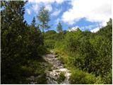 27
27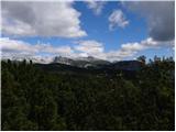 28
28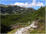 29
29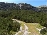 30
30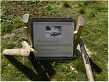 31
31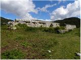 32
32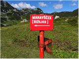 33
33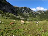 34
34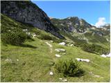 35
35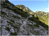 36
36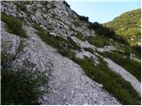 37
37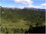 38
38 39
39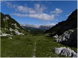 40
40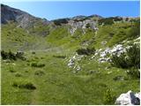 41
41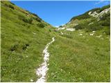 42
42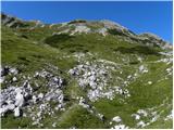 43
43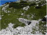 44
44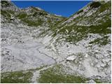 45
45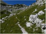 46
46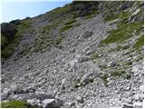 47
47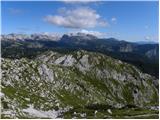 48
48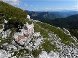 49
49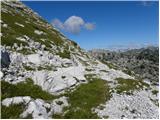 50
50 51
51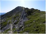 52
52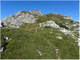 53
53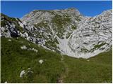 54
54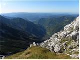 55
55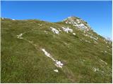 56
56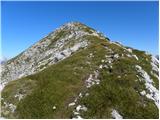 57
57 58
58
Discussion about the trail Koča pri Savici - Mahavšček (via planina Govnjač)
|
| Guest27. 05. 2007 |
samo dodatek;pot na Tolminski kuk je tudi že markirana
|
|
|
|
| VanSims13. 06. 2010 |
Na poti med Mahavščkom in Govnjačem je še nekaj snežnih zaplat ampak se jih da lepo prečiti z nekaj previdnosti.
|
|
|
|
| papillon25. 05. 2016 |
Je kdo hodil po tej poti v zadnjem tednu, je normalno prehodna?
|
|
|
|
| babim28. 08. 2020 |
Ta teden prehodila to pot in ta opisana bližnjica s planine Govnjač do priključka daljše poti je zelo zaraščena z močnim ruševjem in težko prehodna, da je treba kar precej pazljivosti pri vzponu. Kasneje sva se srečala z mlajšim parom, ki sta se pa vračala po tej poti na planino Govnjač in sta pripomnila, da spust ali vzpon po tej bližnjici ni priporočljiv.
|
|
|
|
| ppegan28. 08. 2020 |
Jaz se vedno vračam po tej bližnjici, ko se nahajam v tistih koncih, saj tu običajna pot naredi reees velik ovinek. Je pač malo zaraščena, pa malo bolj je potrebno pod noge gledat, drugače pa ni nekih posebnosti. Komur ne odgovarja, gre lahko naokoli 
|
|
|
|
| babim28. 08. 2020 |
Vse to drži, samo bolje je vnaprej vedeti kakšna je bližnjica, da se potem lahko odločiš za drugo varianto, temu je namenjena tudi moja pripomba.
|
|
|
|
| Enka28. 08. 2024 23:04:23 |
Meni je bila pot zelo všeč, po njej sem se spuščala. Bližnjica je vzorno urejena (posekana in pokošena).
|
|
|
|
| KarmenT9. 07. 2025 10:00:19 |
Ima morda del poti kjer je snežišče (slika 47) tudi svoje ime?
|
|
|