Zadnjica - Križ (via Dovška vrata)
Starting point: Zadnjica (650 m)
| Lat/Lon: | 46,3824°N 13,7604°E |
| |
Name of path: via Dovška vrata
Time of walking: 5 h 45 min
Difficulty: difficult marked way
Altitude difference: 1760 m
Altitude difference po putu: 1790 m
Map: TNP 1:50.000
Recommended equipment (summer): helmet
Recommended equipment (winter): helmet, ice axe, crampons
Views: 13.768
 | 2 people like this post |
Access to the starting point:
From Kranjska Gora, drive over the Vršič pass towards Bovec or vice versa, but only as far as the 50th serpentine of the Vršiška or Ruska road (near the village of Trenta). Here you turn onto a side road, and then park for a few 100 metres in a roadside parking lot.
Path description:
From the parking lot, continue along the road, which takes you past a few houses (mainly at weekends) in about 15 minutes to a place where the road splits into two parts (there used to be a parking lot at the crossroads, but now parking is prohibited).
From the old parking lot, take the road to the left in the direction of Pogačnikov dom na Kriških podih (the road to the right leads to Prehodavci and Dolič). After 15 minutes of further walking, the road leads to the bottom station of the cargo cableway, where it ends.
The ascent continues along a marked footpath (mulatjeri) which climbs moderately through the forest. The path climbs above the valley of the White Stream and quickly leads to very steep slopes (risk of falling rocks), over which a very wide footpath leads. The path then crosses the Veliki Presek ravine, after which you reach a short exposed ledge, which you cross with the help of a rope. The path then returns to the forest, where it climbs moderately in a number of switchbacks. A little further on, the path leads us under a small overhang, where we can see a number of sticks that hikers put up to keep the rock from rolling down into the valley (the sticks are put up more as a joke than for real). The path then crosses a couple of small ravines, and then leads us past a chapel to a larger ravine. With a little care (easy) we cross the aforementioned ravine, after which we climb up to a pleasant resting place (two benches along the way) within a few minutes of further walking. Next, cross another larger ravine (in early summer, the possibility of snowfields), and then the path returns to the forest. Higher up, the forest becomes thinner and the path steeper and more scenic.
The path, which continues to climb along an old mulatier, then passes two more benches and leads to lane of dwarf pines, after which it turns into a rockier world. We continue to climb over small scree fields, along an increasingly scenic path, which leads us higher up to a pleasant little spring.
Only a few 10 steps above the spring, we will come to an unmarked crossroads, where an unmarked path branches off to the right towards Spodnje Kriško jezero (2 minutes), and we continue slightly to the left along a further wide mountain path. The path ahead leads us past small ruins, and we follow it all the way to a marked crossroads, where we continue to the right in the direction of Pihavec, Bovški Gamsovec, Stenar and the Vrata valley (left Pogačnikov dom 3 minutes). We continue our ascent along an increasingly scenic path, from which the path to Pihavec soon branches off to the right. Continue straight ahead on the moderately steep path, which leads us higher up to Dovška vrata, where the next crossroads are. Here continue straight on towards Križ and Stenar (sharp right Bovški Gamsovec, right Gates) along the path which gradually starts to climb towards the Stenar gates. After a few minutes of climbing, the path splits into two parts. Continue left (right Stenar) along the path, which changes from scree to gently exposed slopes, which are traversed in a moderate ascent to the north-west. A rather slippery path leads us higher up to the base of Križa. Here the trail climbs steeply and leads to a slightly exposed ridge where, with the help of a scramble and a rope, we climb to the top of the peak.
Zadnjica - Pogačnikov dom 4:00, Pogačnikov dom - Križ 1:45.

We can extend the trip to the following destinations: Križ,
Stenar
Pictures:
 1
1 2
2 3
3 4
4 5
5 6
6 7
7 8
8 9
9 10
10 11
11 12
12 13
13 14
14 15
15 16
16 17
17 18
18 19
19 20
20 21
21 22
22 23
23 24
24 25
25 26
26 27
27 28
28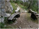 29
29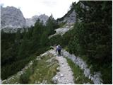 30
30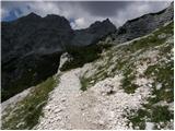 31
31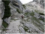 32
32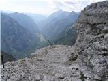 33
33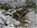 34
34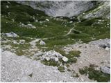 35
35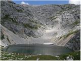 36
36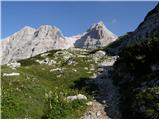 37
37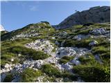 38
38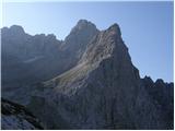 39
39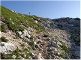 40
40 41
41 42
42 43
43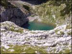 44
44 45
45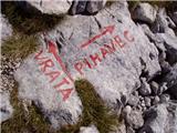 46
46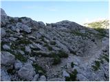 47
47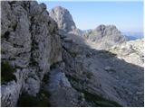 48
48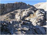 49
49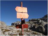 50
50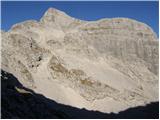 51
51 52
52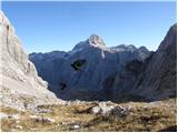 53
53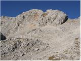 54
54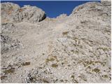 55
55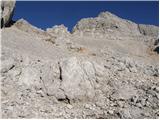 56
56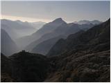 57
57 58
58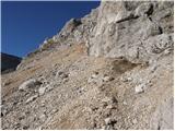 59
59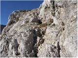 60
60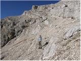 61
61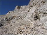 62
62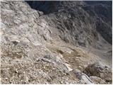 63
63 64
64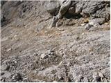 65
65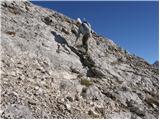 66
66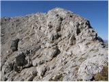 67
67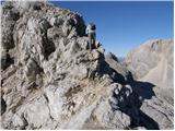 68
68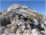 69
69 70
70
Discussion about the trail Zadnjica - Križ (via Dovška vrata)
|
| Victorinox28. 08. 2021 00:44:32 |
Je ta pot uradno sploh še odprta? 24. avgusta sem na Križ prišel po poti čez Bovška vratica in nameraval po tej poti naprej na Stenar preko Stenarskih vratc. Najprej je pod vrhom izruvan klin od jeklenice (sicer to ne povzroča problema tudi pri sestopu), potem pa malo naprej izgleda, kot da se je zgodil podor. Isto idejo za pot je imel še en planinec, s katerim sva nato kar nekaj časa premišljevala, ali je spust varen in gledala teren, saj je pot delovala zasuta. Nato je prišel še nek tuji planinec (ki je skalo zgoraj pod vrhom prečil kar po podoru in prožil velike kamne - če se midva ne bi obotavljala, bi to vse letelo v naju). Skupaj smo nato uspeli priti do Stenarskih vratc, ampak ne ravno po označeni poti, ker je delovala preveč nevarna za spust.
|
|
|
|
| bo_zl28. 08. 2021 20:22:17 |
jaz menim da je ta pot zaprta. Sem hodil leta 2019, sicer iz Dolkove špice na Križ in nato čez Sovatno v Vrata in je bilo na eni skali lepo označeno da je pot direktno iz Križa proti Stenarju zaprta. potrebno se je spustiti nazaj nekaj deset metrov po poti pristopa, čez tisi kratek plezalni del in nato po poti ki preči pobočje pod križa naprej proti odcepu za Stenar.
|
|
|