Starting point: Vršič (1611 m)
| Lat/Lon: | 46,4336°N 13,7435°E |
| |
Time of walking: 1 h 20 min
Difficulty: easy unmarked way
Altitude difference: 476 m
Altitude difference po putu: 476 m
Map: Kranjska Gora 1:30.000
Recommended equipment (summer):
Recommended equipment (winter): ice axe, crampons
Views: 52.523
 | 5 people like this post |
Access to the starting point:
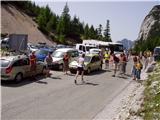
From Kranjska Gora drive towards Bovec or vice versa, but only as far as the Vršič pass, where you park.
Path description:
From the parking lot at Vršič, follow the initially poorly marked path leading to Mojstrovka and Sleme. After a short climb, the path leads us to a larger rock on which we see the inscription Mojstrovka on the left. Continue in the direction of Mojstrovka (to the right Mojstrovka on the Hanzo trail and Slemenova špica) along the trail, which climbs crosswise through a rare larch forest. After about half an hour's ascent, the path leads to a large scree field below Mojstrovka. At the point where the marked path to Mojstrovka approaches the wall, we come to an unmarked crossroads where we continue to the sharp right. Continue the ascent along the unmarked path, which leads us in a slight cross-climb towards the slopes of Šitna glava. A relatively visible path soon leads us into an unmarked valley between Mala Mojstrovka and Šitna glava. Here the trail turns slightly left and climbs slightly more up the increasingly rocky slope. When the trail is quite close to the summit, it turns right, crosses a partly overgrown scree field and then climbs to a grassy summit.

Pictures:
 1
1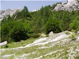 2
2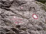 3
3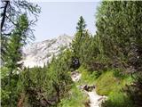 4
4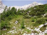 5
5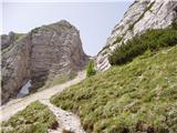 6
6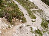 7
7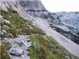 8
8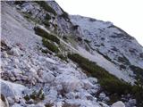 9
9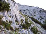 10
10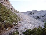 11
11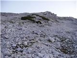 12
12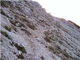 13
13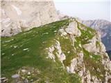 14
14
Discussion about the trail Vršič - Šitna glava
|
| v196010. 07. 2006 |
Z Šitne glave ,ki je porasla z zeleno travco lahko v miru opazujete vrvež na Mojstrovki.Priporočam.
|
|
|
|
| Guest5. 10. 2007 |
Ojla! Kako pa če greš po Hanzovi pa potem na sedlu namesto na Mojstrovko pičiš levo? Hvala 
|
|
|
|
| nekdo127. 06. 2008 |
je še kakšno snežišče na poti? kaj pa na mojstrovko je še kaj snega?
|
|
|
|
| Tadej27. 06. 2008 |
Do Šitne glave in naprej do Mojstrovke je kopno.
|
|
|
|
| Kriška27. 07. 2009 |
Na Šitno glavo se lahko vzpnete po zgoraj navedeni neoznačeni poti, ali pa po "spodnji", ki je trenutno videti bolj shojena in je na gosto označena z možici. Če boste šli po tej drugi, priporočam, da se pred zadnjim zelo strmim meliščem usmerite v desno (z možici označena stezica vodi rahlo v levo), ter po bolj trdnem terenu z manjšim naklonom dosežete vrh. Fotografija predela je dodana pod "trenutne razmere".
|
|
|
|
| Jerneja017. 11. 2012 |
Morda kdo ve kakšna je trenutno pot? Je zaledenela? Cepin res obvezen, ali dereze zadostujejo? Hvala za odgovor.
|
|
|
|
| IgorZlodej7. 11. 2012 |
Cepin in dereze se načelno uporabljajo skupaj. No s Triglava poti nisem videl, vsekakor pa je nekaj poprha, kjer si ne z enim, ne z drugim veliko ne bo dalo pomagat ali pač.
|
|
|
|
| mkrasev11. 08. 2013 |
danes je bilo na Vršiču kot u mravljišču, pa tudi na mojstrovko je bila zjutraj že kar kolona, bravi balzam je bilo u tišini uživat na Šitni glavi, na Mojstovko pa sem šla mal kasneje, ko se je gužva že polegla, bil je čudovit sončen dan , priporočam
|
|
|
|
| ciklama9. 11. 2015 |
Včeraj iz Vršiča na Šitno glavo, vreme poletno, gneče nobene, za razliko od poti na Mojstrovko! Pot lepo sledljiva s postavljenimi možici. Z vrha pa prelep razgled in uživancija v samoti!
|
|
|
|
| KatkaV17. 10. 2018 |
Poti nebi ravno dala v kategorijo lahka, res pa je da tudi v kategorijo delno zahtevna ne spada, morda nekje vmes, pa škoda ker ni gor vpisne skrinjice in žiga. Razgled pa čudovit
|
|
|
|
| michael6619. 10. 2018 |
Če pa ta pot ni lahka,v vseh pogledih,potem pa nobena ni lahka 
|
|
|
|
| georgia27. 07. 2019 |
Ta vrh sva ta teden osvojila mimogrede na poti na Malo Mojstrovko. Pa četudi bi šla samo do Šitne glave in nazaj - v izobilju je čudovitih razgledov, cvetlic (ogromno triglavskih rož pod vrhom), predvsem pa ljubega miru in tišine - za razliko od Vršiča in ostalih obleganih vrhov. Potki se lepo sledi, vseskozi so tudi možici. V bistvu je to eden naših najlažjih dvatisočakov. Vsekakor se midva sem še vrneva. Priporočam!
|
|
|
|
| J.P.31. 08. 2019 |
Izjemno lep vrh, krasni razgledi in posebnost ,ki se upam, ne spremeni: neobljuden. Lp
|
|
|
|
| keti121. 09. 2020 |
19.9.sem bila na Nad Šitom glavi. Tudi jaz te poti ne bi uvrstila prav med lahke. Je verjetno najhitreje dostopen dvatisočak, zanesljivo pa ne najlažji. Pa sem zelo vajena tudi hoje po neoznačenih poteh in brezpotjih. Po odcepu z markirane poti gre pot sprva lepo prečno in je lahka in jasno razvidna, ko pa se začne strmeje vzpenjati, je na nekaj mestih zoprno gruščnata in tudi slabo sledljiva. Prav veliko možicev nisem videla. Po logiki sem sledila strmemu skrotju direkt navzgor in šele višje prečila v desno, kar se je izkazalo za pravo, saj sem potem spet izsledila stezico, ki me je pripeljala proti vrhu. Pri sestopu je bila pot nekoliko lažje sledljiva. Ko bom šla naslednjič, bo sigurno bistveno lažje, ker mi je zdaj orientacijsko vse jasno, ob prvem obisku pa ni tako lahko, ker se pot v sredini kar izgubi. Ne bi jo priporočala tistim, ki niso vajeni slabših neoznačenih poti ali družinam z manjšimi otroki, ker niti tehnično, niti orientacijsko ni čisto enostavna.
|
|
|
|
| Navadni Nimda21. 09. 2020 |
HRIBI.NET - če kliknem na zemljevidek na tej strani, se prikaže prazna vsebina. Kje je zemljevid? Sicer pa krasne fotke in odlična navodila, da ne bomo samo kritizirali!
|
|
|
|
| keti122. 09. 2020 |
Moj zapis ni bil nikakor mišljen kot kritika ampak samo opis realnega stanja, ki bo morda komu v prihodnje v pomoč. Srečno!
|
|
|
|
| Majdag20. 09. 2023 17:34:18 |
18.9.....Vršič in ples meglic. Obetalo se je lepo potepanje, pa se meglice prehitro zapodijo za nama. Na vrhu je bilo že vse sivo. Pa še močan veter je začel in mrzlo je bilo. Všeč so mi meglice, razgledov pa ni bilo. Lep dvatisočak je Šitna glava. Malo pred Grebencem, desno, je na kamnu rdeča črta in po njej je lepa pot.. https://jelenkamenmajdag.blogspot.com/2023/09/sitna-glava-v-meglicah.html
|
|
|
|
| michael6620. 09. 2023 20:55:34 |
Majda,a pol ni blo nič z razgledom na Mangart  .
|
|
|
|
| Majdag21. 09. 2023 08:45:12 |
michael66, razgledi v sivih odtenkih. Bodo pa naslednjič, ni za obupat..
|
|
|