Uskovnica (Razpotje) - Vodnikov dom (via planina Spodnji Tosc)
Starting point: Uskovnica (Razpotje) (1215 m)
| Lat/Lon: | 46,3267°N 13,9107°E |
| |
Name of path: via planina Spodnji Tosc
Time of walking: 3 h 30 min
Difficulty: difficult marked way
Altitude difference: 602 m
Altitude difference po putu: 800 m
Map: Triglav 1:25.000
Recommended equipment (summer): helmet
Recommended equipment (winter): helmet, ice axe, crampons
Views: 23.021
 | 1 person likes this post |
Access to the starting point:
a) Leave the Gorenjska motorway at the exit for Lesce, then follow the signs for Bled and Pokljuka. Continue through Gorje and past the ski resort Zatrnik to Rudni Polje on Pokljuka, where there is a large pay parking lot and a military barracks and shooting range nearby. From here, continue straight along the macadam road, which leads us a little further to a crossroads, where we turn left in the direction of Uskovnica (right mountain pasture Konjščica). From here, drive another 500 m to the former parking lot above Uskovnica. This area is called Razpotje.
Nowadays, parking is forbidden in this parking lot, so you have to park at Rudno Polje, which will take about 35 minutes longer, or choose the starting point at Uskovnica (Lom).
b) From Železniki or Podbrdo, drive to Bohinjska Bistrica, then continue in the direction of Bled. Shortly after the Petrol station, which is located just after Bohinjska Bistrica, turn left in the direction of Pokljuka and Jereka. The road climbs steeply at first, then gradually flattens out behind Koriti, leading to a junction by the bus station, where you continue right in the direction of Pokljuka, Koprivnik and Jereka (straight ahead Srednja vas). Just after the crossroads we arrive at Jereka, and from the crossroads in front of the church we continue straight on towards Pokljuka (left Podjelje). After Jereka the road starts to climb steeply again, and higher up it levels off and continues along the Mrzle potok. When you join the road from Bled, go left and drive to Rudno Polje, where there is a large pay parking lot, and also a military barracks and a shooting range nearby. From here, continue straight on the macadam road, which leads us a little further to a crossroads where we turn left towards Uskovnica (right mountain pasture Konjščica). From here, drive another 500 m to the former parking lot above Uskovnica. This area is called Razpotje.
Nowadays, parking is forbidden in this parking lot, so you have to park at Rudno Polje, which will take about 35 minutes longer, or choose the starting point at Uskovnica (Lom).
Path description:
From the former parking lot at the crossroads, continue along the forest road, closed to public traffic, which begins to descend steeply towards the Ribnica stream gorge. After a short descent, you reach the gorge, over which a wide car bridge leads. The road is laid after the bridge and after a few minutes of further walking leads us out of the forest and onto the vast meadows of Uskovnica.
Here you walk to the nearby chapel, and then continue slightly to the right along the road that runs right next to the chapel (to the left the cottage at Uskovnica, to the right mountain pasture Konjščica). The rather sloping road leads us on across the extensive meadows of Uskovnica, and then leads us to the edge of the forest, where it begins to turn into an initially wide cart track. Cart track, which then starts to climb moderately, has a few forks and we follow it in the direction of Vodnikov dom and Triglava. Higher up, the cart track, most of which runs through the forest, turns into a footpath, which quickly leads us to a pleasant little spring. At the well, continue straight ahead (hunting lodge on the right) and continue the ascent along the gently sloping path, which leads us slightly further up the steep slopes. Soon after we have reached the steep slopes, the fixed safety gear are helpful in crossing the steep ravine. The route continues along relatively steep and, especially in wet conditions, slippery slopes. While crossing the steep slopes, the path climbs steeply for a short time and then descends again. In the last part of the crossing, some very steep ravines are crossed, over which the path is in places completely destroyed (high risk of slipping). The crossing ends at a large torrent (usually a small spring), after which you enter a softer world of grasses.
A few minutes of easy walking and the path leads to the abandoned mountain pasture of Lower Tosc. The way forward begins to climb moderately and soon leads us to a small crossroads where we continue to the sharp right (straight on an old, partly abandoned path) along a well-traced trail. The way forward starts to climb steeper and steeper and quickly leads us out of the belt of sparse forest between dwarf pines, where it starts to turn more and more to the left. The path soon becomes flat and from dwarf pines it leads to grassy slopes over which, within a few minutes' further walking, we climb to the Pokljuka - Triglav path, where we turn left. The route continues across the southern slopes of Tosc. The path then crosses a short strip of sparse forest in a gentle downhill, and then leads to steep slopes. A little further on, the path crosses the precipitous slopes of Tosc on an artificially created wide ledge in a gentle descent. As the path is quite wide it does not cause any problems (caution due to falling rocks, rock fall in 2008). The path then climbs gently again and leads to a crossroads where we continue to the right in the direction Vodnikov dom. There is a further walk of about ten minutes without any major ascents or descents to Vodnikov dom in Velo Polje.

We can extend the trip to the following destinations: Cesar,
Koča na Doliču,
Vernar,
Dom Valentina Staniča pod Triglavom,
Vrh Snežne konte (1 h 45 min),
Šmarjetna glava,
Dom Planika pod Triglavom,
Visoka Vrbanova špica,
Begunjski vrh,
Triglavski dom na Kredarici,
Rjavina,
Triglav (2 h 50 min)
Pictures:
 1
1 2
2 3
3 4
4 5
5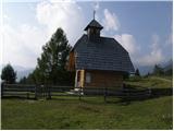 6
6 7
7 8
8 9
9 10
10 11
11 12
12 13
13 14
14 15
15 16
16 17
17 18
18 19
19 20
20 21
21 22
22 23
23 24
24 25
25 26
26 27
27 28
28 29
29 30
30 31
31 32
32 33
33 34
34 35
35 36
36 37
37 38
38 39
39 40
40 41
41 42
42 43
43 44
44 45
45 46
46 47
47 48
48 49
49 50
50 51
51 52
52 53
53 54
54
Discussion about the trail Uskovnica (Razpotje) - Vodnikov dom (via planina Spodnji Tosc)
|
| Barpka9. 08. 2015 |
A je mogoče kdo zadnje čase hodil po tej poti? Je res na mestih tako razdrta kot na fotkah?
|
|
|
|
| valerija1129. 08. 2015 |
Moj odgovor se sicer nanaša na prehojeno pot lani jeseni. Upam,da dobiš še bolj frišnega. No,lani je bila,kot piše zgoraj v opisu, na nekaterih mestih potrebna večja previdnost.Najtežje smo prečili tisto grapco s potočkom. Smo povprečni planinci,pa ni bilo težav,lepa pot. Vračali smo se čez planino Konjščico. Srečno.
|
|
|
|
| primozstu10. 08. 2015 |
Včeraj šel v obratni smeri. Pot je za povprečnega planinca normalno prehodna, na nekaj mestih je potrebna večja pazljivost zaradi ozke steze, manjšega podora in nevarnosti zdrsa na peščeni podlagi. Ni primerno za male otroke, drugače pa je OK.
|
|
|
|
| Barpka12. 08. 2015 |
Hvala obema za odgovor, mi jo je uspelo prehodit brez težav.  Potka čez Čiprije je zelo lepa, še posebej fina za vroče poletne dni, popravljena (fotke ne kažejo realnega stanja), so pa res na nekaterih mestih manjši podori (naštela sem pet sitnih mest), na katerih previdnost ni odveč. Meni je največjo težavo delalo prav mesto s peščeno podlago, kjer ni bilo poti, na kateri te lahko hitro odnese v dolino. Za vrtoglave pa pot vsekakor ni primerna.
|
|
|
|
| grega_p12. 09. 2021 19:37:47 |
Na netu sem našel obvestilo ( https://www.pzs.si/novice.php?pid=13584), da je pot spet ODPRTA. Šel sem po njej do Vodnikovega doma. Tisti najbolj problematični odsek (podor) ima utrjene stopnice v pesku in zdi se mi, da je PD Srednja vas dobro opravil delo. Edino, kar me je zmotilo je bilo to, da so še zmeraj pustili table, da je pot začasno zaprta. In sicer ne spodaj pri Uskovnici, temveč samo na omenjenem 5min odseku, nekako po približno 1h hoje. Je kakšen namen ali se jih samo ni odstranilo? Upam, da koga ne odvrne od nadaljevanja poti, saj je normalno prehodna, seveda z določeno mero pazljivosti.
|
|
|