Selva / Wolkenstein Vallunga - Piz de Puez / Puezspitz
Starting point: Selva / Wolkenstein Vallunga (1608 m)
Time of walking: 3 h 50 min
Difficulty: partly demanding marked way
Altitude difference: 1305 m
Altitude difference po putu: 1305 m
Map: Tabacco 05 Val Gardena - Gröden - Alpe di Siusi - Seiseralm (1:25.000)
Recommended equipment (summer):
Recommended equipment (winter): helmet, ice axe, crampons
Views: 739
 | 1 person likes this post |
Access to the starting point:
a) Access from Gorenjska: Drive through the Karavanke Tunnel into Austria, then continue to Spittal and on to Lienz (the motorway ends a little after Spittal). We continue along a relatively nice and wide road through the Drava Valley, which leads us into Itali. The road continues past Dobbiaco / Toblach, Brunico / Bruneck, Brixen / Bressanone to Chiusa / Klausen, where we turn left towards Val Gardena. Passing Ortiseio / St. Ulircha and St. Christine, you reach the village of Selva di Gardena / Wolkenstein. Turn left in the village and after one kilometre you will reach the parking lot in front of Vallunga Valley / Langental (parking fee).
b) From the coastal side: From Nova Gorica, drive into Itali and continue on the motorway to Portogruaro, where you turn off at the motorway junction towards Belluno. Follow the motorway to its end (do not turn towards Belluno) and then continue to Cortina d'Ampezzo. When you arrive in Cortina d'Ampezzo, follow the signs for the Passo Falzarego Alpine Pass. At the Passo Falzarego (2105 m), turn right into the neighbouring Passo Valparola (2192 m), and from there descend into the Val Badia valley. Turn left here and descend via Corvaro over the Gardena Pass to Selva di Gardena / Wolkenstein. Turn right in the village and after one kilometre reach the parking lot in front of Vallunga Valley / Langental (parking fee).
Path description:
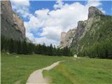
The walk starts at the large wooden fence at the beginning of the Vallunga/Langental valley. The path through the valley, alternating between forest and meadows, ascends only gently, so that you can observe the vertical walls of the Stevia and Pueza plateaus on one side and the Chedul plateau on the other. After a good half an hour, you reach a crossroads where you continue straight ahead along the valley (on the left, the option to the Puez/Puez hut/Riffugio Puez). You cross a large mountain pasture (water). The path narrows, turns right into a gully and becomes a little steeper. Climb up alongside a stream in a clotted gully. The Puez waterfall falls over the slope to the left. After a narrowing at the crossroads where the stream emerges, continue left (path number 14) towards the Puez (water) hut. The path rises steeply to extensive grassy slopes below the cliffs, under which you cross to the left again on a more level path. It is a steep climb up to the Puez hut, which is situated on a large plateau (water). It took us just under two hours to get here.
From the hut, continue along route 14 towards the summit. We climb in switchbacks over a grassy slope to a rocky ridge. The path crosses above the mountain pasture Puez, below the summit buttress of the Col du Puez (2725 m), to a waterhole, where it is easy to climb to a broad saddle between the main summit and the eastern summit. Continue left (unmarked path on the right to Col de Puez (2725 m)) and climb steeply up a wide gully, first over a grassy slope and then over a scree slope. The steepness does not ease until you reach a small saddle where the path turns left. In a few minutes we are at the top of Pic Puez/Puezspitze (2913 m).

Pictures:
 1
1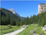 2
2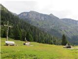 3
3 4
4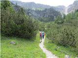 5
5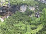 6
6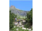 7
7 8
8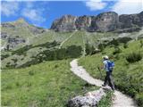 9
9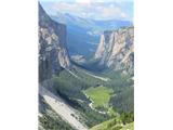 10
10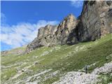 11
11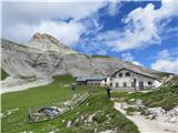 12
12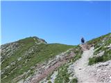 13
13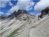 14
14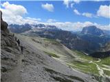 15
15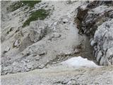 16
16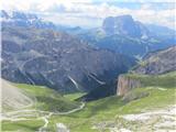 17
17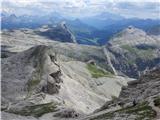 18
18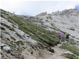 19
19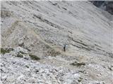 20
20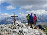 21
21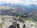 22
22
Discussion about the trail Selva / Wolkenstein Vallunga - Piz de Puez / Puezspitz