Sella Nevea - Monte Cregnedul (unmarked mule track)
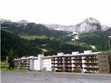
Starting point: Sella Nevea (1176 m)
| Lat/Lon: | 46,3908°N 13,4755°E |
| |
Name of path: unmarked mule track
Time of walking: 3 h 45 min
Difficulty: partly demanding unmarked way
Altitude difference: 1175 m
Altitude difference po putu: 1175 m
Map: Tabacco 019 1:25000 ali Julijske Alpe -Zahodni del (PZS) 1:50000
Recommended equipment (summer): helmet
Recommended equipment (winter): helmet, ice axe, crampons, lamp
Views: 12.709
 | 4 people like this post |
Access to the starting point:
a) Cross the Rateče border crossing and drive to Trbiz/Tarvisio. Just before Trbiz, turn left towards Predel or Bovec and follow the road to the crossroads in front of Lake Rabeljsko Jezero. Here, turn right towards the Nevea Pass/Sella Nevea. At the saddle, you can park on the gravel parking lot under the small ski slope on the right, higher side.
b) From Bovec, descend via Predel to the Italian side. Just after Lake Rabeljsko, at the crossroads, turn left towards the Sella Nevea/Na Žlebeh saddle.
c) From the road between Vidmo and Trbiz, at Kluže/Chiusaforte, follow the valley of the Reklanica to the pass, past the lower station of the gondola lift and the turn-off for mountain pasture Pecol to the ski resort on the left-hand side of the road.
Path description:
Along the road you will see several signs indicating route 625 towards the Corsi hut. Go up the slope on the less well-trodden track, which leads to a dirt road that climbs up the right-hand side of the ski slope. Follow the road for a short distance before signs point you left into the forest. After a short climb, you reach a crossroads where you continue to the right on route 625, and a path branches off to the left towards mountain pasture Krni dol/Cragnedul and on towards Pecol and the Brazza hut. The path then continues to climb through the forest and leads to a crossroads where another path branches off to the left, leading to the nearby mountain pasture. At 1624 m we come across ruins. Here, leave the marked route 625, which leads to the right onwards towards the saddle Passo degli Scalini (2022 m), and follow the well-trodden path - the mulatier - into the slopes below Špik nad Špranjo/Modeon del Buinz and later into the Planota side ridge. The unmarked trail zigzags over extensive grassy slopes, where in summer there is a paradise for flower lovers and photographers, and usually lots of ibex. The Mulatjera leads to a side ridge, crosses it and, alongside the remains of military structures, leads to Krnidolska škrbina (about 2320 m), from where the nearby summit is easily accessible. Just below the stump is a cavern with a window. At the stump, our route joins the marked Ceria-Merlone Ferrata, which allows us to descend by ladder to the right to the stump of the Front Spur and to the Corsi hut below Viš, and to the left begins an almost horizontal traverse of ledges, which leads in less than half an hour to the Spur of Planja (2411 m), and then below the sharp ridge of the Lower Peaks to the stumps of La Val, the Spur of Špranja (2558 m) and Foronon del Buinz (2531 m).
To the right of the cavern, look for the easiest passages and reach the viewpoint in a few minutes. There is a larger cairn.
The pathless climb to the summit (3 minutes) is a notch harder than walking on the partially broken mulatier.

Pictures:
 1
1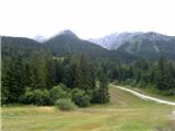 2
2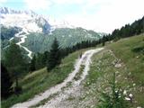 3
3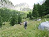 4
4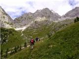 5
5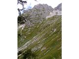 6
6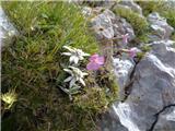 7
7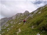 8
8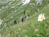 9
9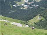 10
10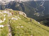 11
11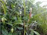 12
12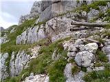 13
13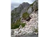 14
14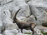 15
15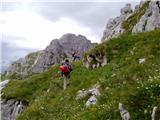 16
16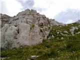 17
17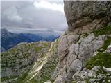 18
18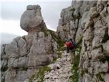 19
19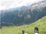 20
20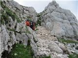 21
21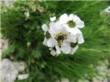 22
22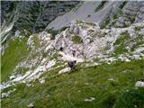 23
23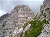 24
24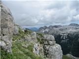 25
25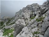 26
26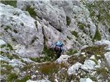 27
27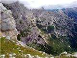 28
28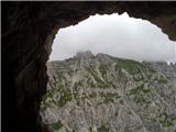 29
29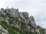 30
30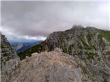 31
31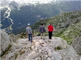 32
32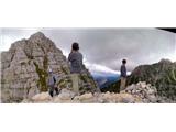 33
33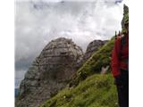 34
34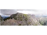 35
35
Discussion about the trail Sella Nevea - Monte Cregnedul (unmarked mule track)
|
| damijanp16. 08. 2011 |
Prejšnji teden, ko je bila na večini poti gneča, smo se odpravili na ta izlet. Na kratko: mir, čudovita narava, kozorogi, rože ... in samota, saj nismo (od odcepa za VKD pri ruševinah) srečali nikogar. Skratka, balzam za dušo. Zelo toplo priporočam. Slike so na naslednji povezavi: Vrh Krnega Dola
|
|
|
|
| darinka415. 06. 2022 06:07:02 |
Bili včeraj. Po novih nepoznanih poteh. Kajti nihče od nas še ni bil tu gor. Razen kozorogov nismo srečali nikogar. Si vzeli čas za ogled ostankov ostalin s prve vojne. Dan sicer ni bil sončen. Kar nekaj oblačnosti. Se je odpiralo in zapiralo.Nas sploh ni motilo. Imeli smo radovedne poglede kozorogov na poti. Tudi na vrhu. Starih , mladih, mater z mladički. Tu imajo svoj mir. Na vrhu smo se zadržali kar nekaj časa. Takrat se je nebo odprlo in smo imeli razglede. Sestopili smo po isti poti . Za konec smo se ustavili ob Rabeljskem jezeru. In midva z Renatotom zaplavala. Dan , kakršnega si lahko le želiš.
|
|
|
|
| darinka48. 07. 2023 16:23:33 |
Zdej mi je bolj jasno kako zgledajo tam poti. Tale pot z Žlebi sicer ni označena s številkami. Je pa odcep do Corsija s 656 upam da se nisem zmotila. Z vrha sva sestopila po plezalni poti. V ta namen sva rabila samovarovalni komplet. Zajle so zgleda na novo postavljene. Klinov niti ni. Si poiščeš stopinje v skali. Kjer se zajle končajo je še edino snežišče , ki ga je treba prečiti. Potem gre del poti po melišču na pot čez sedlo Scallini , kjer sva prišla na izhodišče. Zgleda da ni noben še hodil . po tej strani. Razen kozorogov.
|
|
|
|
| mirank9. 07. 2023 07:37:38 |
Če ima pot številko na srednjem polju to pomeni, za brezhibnost oznak in varoval skrbi določeno CAI, PD po naše.
|
|
|