Scicchizza - The lake Zgornje Mangartsko jezero
Starting point: Scicchizza (857 m)
| Lat/Lon: | 46,4819°N 13,6749°E |
| |
Time of walking: 20 min
Difficulty: easy marked way
Altitude difference: 72 m
Altitude difference po putu: 95 m
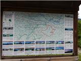
Map: Julijske Alpe - zahodni del 1:50.000
Recommended equipment (summer):
Recommended equipment (winter):
Views: 13.489
 | 2 people like this post |
Access to the starting point:
a) First drive to Kranjska Gora, then continue to Rateče and on to Itali. When you reach the village of Fužine / Fusine in Valromana, just after crossing the Jezerski brok, you will see signs for the Mangart lakes / Laghi di Fusine (there are signs in Italian on the roadside). Continue left in the route mentioned above and follow the narrow asphalt road to the hamlet of Scicchizza (a small hamlet) along the Mangart lakes / Laghi di Fusine (there are signs in Italian on the roadside). Park in the roadside parking lot, just after the cycle path joins from the left.
b) Via Border crossing Predel, drive into Itali, then continue to Trbiž / Tarvisio and on to Rateci. When you reach the village of Fužine / Fusine in Valromana, just before the road crosses the Jezerski brok, you will see signs for Mangart Lakes / Laghi di Fusine (there are signs in Italian along the road). Continue to the right in the route mentioned above and continue along the narrow asphalt road, which you follow to the hamlet of Scicchizza. Park in the roadside parking lot, just after the cycle path joins from the left.
Path description:
At the end of the parking lot, you will see a well-maintained tourist trail that branches off the road slightly to the right. The pleasant path continues along the Jezersko brok and leads past several strong karst springs in a gentle to moderate ascent. Higher up, you reach a crossroads at a small dam Spodnje Mangartsko jezero, where you continue left to the nearby road (to the right, a refreshment room and a nice viewpoint from the lake towards Mangart). Continue directly between the road and the lake for a short distance, then just along the lake. On the other side of the lake the path splits and we continue straight on in the direction of Zgornje Mangartsko jezero (the right path goes round the lower lake).
Continue along cart track, which enters the forest and turns right. At this point, cart track climbs steeply for a while, then flattens out and leads to the next crossroads, this time near the climbing area. Continue left here, then gradually start descending. After a short descent, you reach Zgornje Mangartsko jezero and a viewpoint overloking the surrounding mountains.
Description and pictures refer to the situation in 2015 (June).

Pictures:
 1
1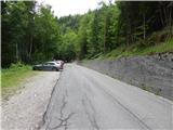 2
2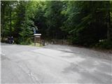 3
3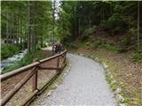 4
4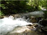 5
5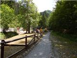 6
6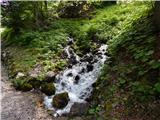 7
7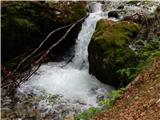 8
8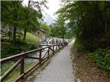 9
9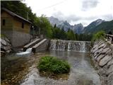 10
10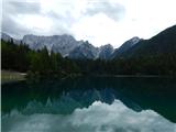 11
11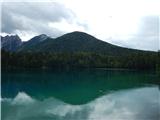 12
12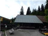 13
13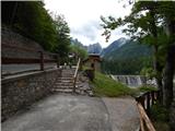 14
14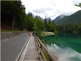 15
15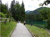 16
16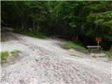 17
17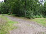 18
18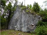 19
19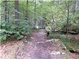 20
20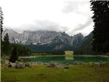 21
21
Discussion about the trail Scicchizza - The lake Zgornje Mangartsko jezero
|
| Guest28. 09. 2006 |
Spodnje jezero je dobro urejeno, zgornje pa je bolj podobno veliki mlaki. Vsaj konec septembra je bilo tako.
|
|
|
|
| seinfeld26. 08. 2016 |
Smo bili včeraj, bi dodal moj predlog poti.
Z avtom se lahko zapelje čisto do spodnjega jezera in tudi naprej. Mi smo parkirali ob zadnjem mostičku pred spodnjim jezerom. Šli smo čez ta most in okrog jezera. Že krepko čez polovico poti okrog jezera je razpotje, kjer je tabla za climbing wall. Tu se zavije desno(ne navzgor proti cesti) in po približno petnajstih metrih levo po označeni vidni poti(ni table). To je najkrajša pot do zgornjega jezera.
Jezeri sta krasni, še posebej spodnje. Tik nad zgornjim pa se dviguje Mangart.
|
|
|