Rudno polje - Planina Konjščica
Starting point: Rudno polje (1347 m)
| Lat/Lon: | 46,3458°N 13,9236°E |
| |
Time of walking: 1 h
Difficulty: easy marked way, easy unmarked way
Altitude difference: 91 m
Altitude difference po putu: 160 m
Map: TNP 1:50.000
Recommended equipment (summer):
Recommended equipment (winter): ice axe, crampons
Views: 31.222
 | 1 person likes this post |
Access to the starting point:
From the motorway Ljubljana - Jesenice take the exit Lesce and follow the road towards Bled. At the traffic lights in Bled, the signs for Pokljuka direct you to the right. Continue through Gorje and past the abandoned ski resort Zatrnik to Rudni Polje on Pokljuka (a large parking lot, a military barracks and a shooting range).
Path description:
From the large parking lot opposite the barracks at Rudne Polje, first cross the road and then look for the start of the forest road (there are also signs for Triglav at the start of the forest road) leading to the Viševnik ski resort. After about 10 minutes' walk along the road, you will arrive at the foot of the ski slope, where the marked trail splits into two parts. The right-hand path leads to Viševnik and Blejska koča na Lipanci, and we continue along the road for a short distance in the direction of Triglav, Vodnikov dom and Studorski Preval. When the road returns to the forest, you will see a marked path on the left, which begins to climb moderately through the forest. After a few minutes, get back on the road, which you will reach at a medium sized parking lot with space for about 20 cars (it is also possible to drive here, this will shorten the journey by about 20 minutes).
When you reach the parking lot, walk along the road for a few 10 m, and then signs will lead you slightly to the right onto a waymarked and well-trodden path that begins to climb through the forest. After a few minutes, the path descends and gradually passes onto the relatively steep southern slopes of Plesišče (1790 m). There are a few minutes of scrambling, and then we reach the back of the aforementioned peak, where the marked path turns right, and we continue straight down in the direction of the inscription on the rock "sour milk".
We continue along the well-trodden but unmarked path, which quickly leads us out of the forest and onto the grassy slopes. Lower down, the path turns slightly to the right and descends in a few minutes to mountain pasture Konjščice. At mountain pasture, the path loses a bit and we walk to the central part of mountain pasture, where we get on a marked path and follow it for a few 10 steps to reach the cheese cottage at mountain pasture Konjščića.
Description and pictures refer to July 2014.

We can extend the trip to the following destinations: Planina pod Mišelj vrhom,
Velo polje,
Vodnikov dom na Velem polju,
Studorski preval,
Ablanca,
Jezerski Stog,
Viševnik,
Prevalski Stog,
Mali Draški vrh,
Koča na Doliču,
Vernar,
Veliki Draški vrh,
Tosc,
Vrh Snežne konte,
Šmarjetna glava,
Dom Planika pod Triglavom,
Visoka Vrbanova špica,
Begunjski vrh,
Triglavski dom na Kredarici,
Rjavina,
Triglav
Pictures:
 1
1 2
2 3
3 4
4 5
5 6
6 7
7 8
8 9
9 10
10 11
11 12
12 13
13 14
14 15
15 16
16 17
17 18
18 19
19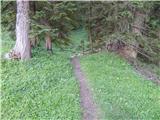 20
20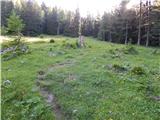 21
21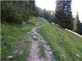 22
22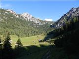 23
23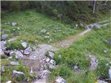 24
24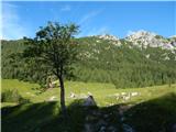 25
25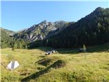 26
26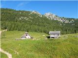 27
27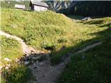 28
28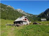 29
29
Discussion about the trail Rudno polje - Planina Konjščica
|
| capraibex24. 09. 2017 |
Med Koprivnikom in Zajamniki je kar nekaj manjših planin,oz. planšarij,nekaj tudi povsem zapuščenih.Ali razen ceste obstaja pot,ki vodi preko omenjenega področja?
|
|
|
|
| dezantone6. 08. 2021 11:56:18 |
Koliko časa se hodi z rudnega polja na Konjščico
|
|
|
|
| dezantone6. 08. 2021 11:57:58 |
Ima kdo telefonsko sirarne na Konjščici
|
|
|
|
| turbo6. 08. 2021 13:46:18 |
Tule bi morda znali kaj več povedati:
Bohinjska sirarna, 041 889 610
(od ponedeljka do petka med 7.00 in 15.00)
|
|
|
|
| exwannabe7. 08. 2021 11:16:50 |
V vednost, da je koča na planini Konjščica zaprta (vsaj bila je teden dni nazaj in nic ni kazalo, da bi bila letos sploh odprta).
|
|
|
|
| Enka28. 06. 2022 21:00:24 |
Letos se je mogoče v planšariji na Konjščici ponovno osvežiti in si kaj dobrega privoščiti.
|
|
|