Ravenska Kočna - Mrzla gora (Slovenian way)
Starting point: Ravenska Kočna (1000 m)
| Lat/Lon: | 46,385°N 14,5364°E |
| |
Name of path: Slovenian way
Time of walking: 5 h 45 min
Difficulty: very difficult marked way
Altitude difference: 1203 m
Altitude difference po putu: 1500 m
Map: Kamniške in Savinjske Alpe 1:50.000
Recommended equipment (summer): helmet, self belay set
Recommended equipment (winter): helmet, self belay set, ice axe, crampons
Views: 29.897
 | 3 people like this post |
Access to the starting point:
From the motorway Ljubljana - Jesenice take the exit Kranj - East and follow the road towards Jezersko. At Zgornje Jezersko, just past the petrol station, you will see a road that branches off the main road to the right (towards Planšarsko jezero). The road then takes you past the lake and climbs steeply behind it for a short distance. Higher up, the road flattens out and loses its asphalt surface at the beginning of a large meadow. The dirt road is then followed to a marked large parking lot.
Path description:
From the parking lot, continue along the macadam road following the signs "Češka koča, Ledine" and after about 15 minutes' walk you will reach the cargo cableway.
From the former parking lot of the cargo cableway, follow the path between the two cableways (the lower station of the cargo cableway to Kranjska Cottage burnt down in June 2015) and then slightly uphill. The path soon leaves the forest and continues through dwarf pines. After a while, the path leads to a ravine called Žrelo. Here we are at a crossroads, where we continue left (straight on through Žrelo), and the path then immediately becomes climbable. The path is well protected, but caution is still needed because of the wet rocks. The path over the short wall is also quite exposed in places, but full of good views. After climbing this part, the route returns to the dwarf pines, through which you then climb on a well-surfaced path. Continue up quite steeply and soon the route through Žrelo joins from the right. From here to Kranjska hut is only a short 10 steps walk.
From the hut, turn left to the east in the direction of Ledinski vrh, Mrzla gora and Rink. The path, which is initially quite steep, leads us in a few minutes to a crossroads, where we go to the right path (left climbing on Babe). The way forward becomes only slightly steeper and leads us to a slightly more difficult passage over a rock peak. Here we are helped by a rope, but the crossing is not difficult in dry conditions. The path then leads us to the wide slopes below Ledinski vrh from which there is a fine view towards the glacier below Skuta, which can be seen on the right. The path then leads us in a moderate ascent to Jezersko sedlo, bordering neighbouring Austria. From Jezersko sedlo, continue right towards Savinjsko sedlo, which is reached after about 15 minutes of cross-country walking. From this saddle, descend towards Okrešl. After a few minutes of descending, we reach a small emergency bivouac, where we sign the entry book (bivouac under Mrzlim vrh). We continue descending and soon reach a crossroads, where the climbing route to Koroška Rinka branches off to the right up the scree, and we continue down. Soon the path to Mrzla Gora branches off to the left at 1700m. The path initially climbs through the rare dwarf pines and then leads us to a steel cable over a rock slab. Here you should put on your helmets, as the path ahead is very crumbly and exposed to falling rocks. From the steel cable the path leads to a ravine which we cross. We now reach the climbing part of the route. The route is well protected at the beginning, but the fixed safety gear soon runs out. There is an unguarded climb up a pyramid-shaped slope. As this part of the path is very steep, watch out for falling rocks. Before you reach the top of the pyramid you have the feeling that there is a summit. But when you get to the "top" you see that this is not the case. There is a very exposed crossing of a narrow shelf without fixed safety gear. At the end of this shelf, the route turns left up a moderately steep wall straight up (without fixed safety gear). The route then follows a ridge which is quite exposed in places. The path then turns slightly to the right and leads to the summit in 30 minutes on quite steep terrain. The path is very difficult and poorly guarded. Helmets are compulsory.
Ravenska Kočna - Kranjska koča 2:00, Kranjska koča - Savinjsko sedlo 1:15, Savinjsko sedlo - Mrzla gora 2:30.

Pictures:
 1
1 2
2 3
3 4
4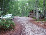 5
5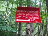 6
6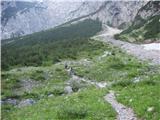 7
7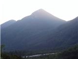 8
8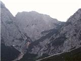 9
9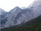 10
10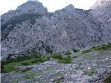 11
11 12
12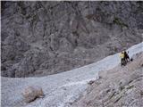 13
13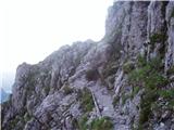 14
14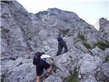 15
15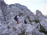 16
16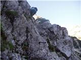 17
17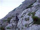 18
18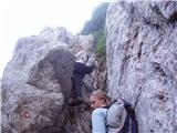 19
19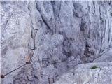 20
20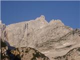 21
21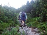 22
22 23
23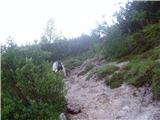 24
24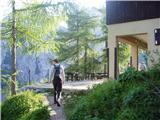 25
25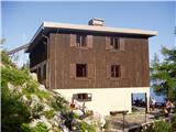 26
26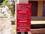 27
27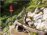 28
28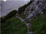 29
29 30
30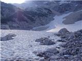 31
31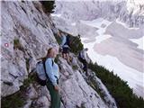 32
32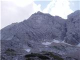 33
33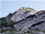 34
34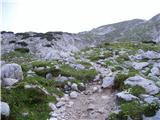 35
35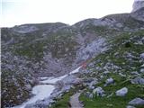 36
36 37
37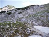 38
38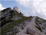 39
39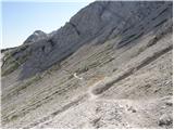 40
40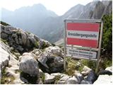 41
41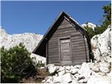 42
42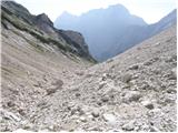 43
43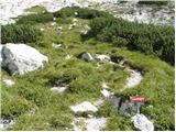 44
44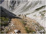 45
45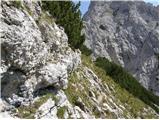 46
46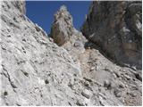 47
47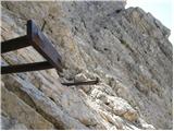 48
48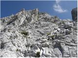 49
49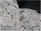 50
50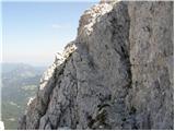 51
51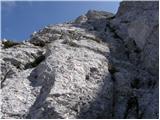 52
52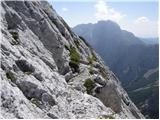 53
53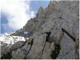 54
54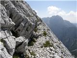 55
55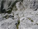 56
56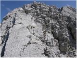 57
57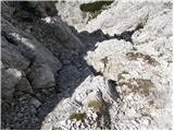 58
58 59
59 60
60
Discussion about the trail Ravenska Kočna - Mrzla gora (Slovenian way)
|
| Guest18. 09. 2006 |
Sploh, če greš pri povratku še po plezalni na Rinke 
|
|
|
|
| toncek13. 04. 2007 |
resnično lepo dozivetje, še lepse je pa res ,ce se vračaš čez križ.

|
|
|
|
| Ghosting10. 08. 2007 |
Hi! Is it true that the route from Matkov kot is poorly marked? Is better to start from Matkov kot and then go down to Okreselj or vice versa?
|
|
|
|
| Guest10. 08. 2007 |
It's better to start from Logarska dolina and then go over Okrešelj.
|
|
|
|
| Guest10. 08. 2007 |
Hi Gost! According to planinskodrustvo-medvode the route from Matkov kot is well marked but poorly protected. I don't know but some hikers who went down from Mrzla gora to Matkov kot had problems with orientation. So it's probably better come up over Skaf and then go down over Okreselj.
|
|
|
|
| Guest11. 08. 2007 |
Ali so morda naredili novo pot, ki pelje iz Mrzlega dola preko Rink na Ledine (obstoječa se namreč mnogo, mnogo pod vrhom priključi poti z Ledin na Rinke oz.Križ)?
Pa lep planinski pozdrav
|
|
|
|
| Guest11. 08. 2007 |
Plezalna pot iz Mrzlega dola na Rinke se Priključi poti z Ledin malo nad Jezerskim sedlom. Direktne poti iz Mrzlega dola na Rinke ni. Lp
|
|
|
|
| Guest16. 10. 2007 |
Pozdravljeni, pot čez mrzli dol na Mrzlo goro in na Rinke so po mojem pojmu najzahtevnejše v Kamniško-Savinjskih alpah. Ampak to je samo moje mnenje. Ni kaj, perfektno za vse ki se ne bojijo višin, izpostavljenosti in so jim všeč take poti. Lep hribovski pozdrav !
|
|
|
|
| grahlck3. 06. 2009 |
Ali je res da je ta pot slabo zavarovana?
|
|
|
|
| mosovnik4. 06. 2009 |
Pot je zahtevna, varovana na najtežjih mestih, v megli orientacijsko zelo zahtevna in naj se je lotijo izkušeni , še najbolje v spremstvu poznavalca/vodnika.
|
|
|
|
| velkavrh14. 06. 2009 |
Po tej poti šel pred kakšnim letom v skupini še treh gospa in enega gospoda,nihče ni bil več rosno mlad,vendar so bili dobri plezalci.To je edina pot po Kamniško Savinskih Alpah,ki je naravna,razen na začetku brez varoval,en nevaren del se kar prejaha.Imeli smo še močan veter,kar je še oteževalo vzpon.Treba je res imeti dobro orientacijo in dobro slediti markacijam.Spust je ravno tako zahteven,na enem delu smo si pomagali z vrvmi.Adrenalinsko!
|
|
|
|
| stuchlyan26. 06. 2010 |
Včeraj smo bili gor. Matkov kot - Mrzla gora - Okrešelj. Ena lepših markiranih tur kar jih poznam, sploh v Kamniško Savinjskih Alpah. Super ambient.
Pot mimo Matkovega škafa proti vrhu je v bolj slabem stanju: obledele markacije (sploh vršni del), nekaj portganega in izpuljenega, vendar problemov ni.
Zahodni greben pa je poslastica z dobro skalo, a kar precej naloženega kamenja - čelada obvezna. Zavarovana je skromno, a solidno - ravno prav za tiste, ki jim je namenjena: torej planincem, ki jim je ljubše prijeti za skalo kot železo. Ni za družinske izlete. Tistim, ki so ji dorasli bo zagotovila lepo doživetje. Varovanja z vrvjo pa naj se loti tisti, ki ga je vajen in ga obvlada.
LP Andrej
|
|
|
|
| nevica11. 09. 2011 |
Končno osvojila tudi to markanto goro v KSA. Pot je sicer iz koče na Ledinah kar dolga vendar vredna vsakega truda. Vremenski pogoji so bili odlični (suha skala, malo drobirja na poličkah), je pa potrebna 100% koncentracija pri spustu. Na vrhu Mrzle gore smo se družili z markacisti, ki so obnavljali pot iz Matkovega kota. Uživala pri vsakem koraku.
|
|
|
|
| frenk4510. 02. 2012 |
zanima me s katero potjo se še lahko primerja ta zahtevna gora.
|
|
|
|
| otiv10. 02. 2012 |
@frenk45 o tem je bilo že veliko napisanega,če ti plezanje po izpostavljenih stenah z malo varovali ne dela težav,potlej tudi na Mrzli gori ne bo problemov.Je pa skalovje ostro in so zelo priporočljive rokavice,zaradi krušljivosti pa vsekakor čelada.
|
|
|
|
| ljubitelj gora10. 02. 2012 |
...pa nikakor it takrat, ko bodo mokre skale.
|
|
|