Prelaz Vrhe - Donačka gora
Starting point: Prelaz Vrhe (426 m)
| Lat/Lon: | 46,2583°N 15,7586°E |
| |
Time of walking: 1 h 35 min
Difficulty: difficult marked way
Altitude difference: 458 m
Altitude difference po putu: 495 m
Map: Rogaška Slatina z Bočem in Donačko goro 1:25.000
Recommended equipment (summer): helmet
Recommended equipment (winter): helmet, ice axe, crampons
Views: 36.910
 | 4 people like this post |
Access to the starting point:
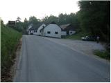
From the Ljubljana - Maribor motorway, take the Dramlje exit and follow the road towards Šentjurje, Rogaška Slatina and Rogatec. In Rogatec, the signs for Donačka gora direct you to the left onto a slightly narrower road, which you then follow towards the village of Žetale. At a small pass, just at the point where the municipality Rogatec ends, you will see a slightly larger parking lot on your right, where you park.
Path description:
From the parking lot, first walk to the pass, where you continue along the left ascending road in the route Donačka gora. After a short climb, just a few metres beyond a thatched-rof house, the signs for Donačka gora direct you right onto a folded cart track, which after a few steps goes into a short lane of wods.
Cart track quickly emerges from the forest and then continues along the grassy hay meadows. Higher up, the path leads to a secluded farmhouse, past which a waymarked path leads. Just above the farm, we join the slightly wider cart track which we follow to the right (to the left St George and St Donatus). Cart track, which continues to climb cross-country, leads us mostly through the forest to the next crossroads, where we continue to the left in the direction of Donačka gora (to the right Žetale).
After a short climb on a well-made path, the path from Rudi's house joins us from the right. Here we continue straight in the direction Donačka gora on the path, which climbs quite steeply. When the steepness subsides, the steep slopes are crossed. The way ahead leads us under the steep summit slope of the eastern peak Donačka gora. A very steep climb follows, along a well protected path to the ridge. Here, 20m off the path to the left, is the eastern summit of Donačka gora (marked, the last few metres secured with rungs).
Continue right along the path, which initially descends slightly, then ascends along the ridge of Donacca Mountain. After about 20 minutes of walking on a steep, overgrown ridge, you will reach the western summit, where there is also a registration box.

Pictures:
 1
1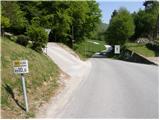 2
2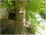 3
3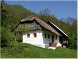 4
4 5
5 6
6 7
7 8
8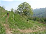 9
9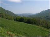 10
10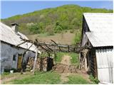 11
11 12
12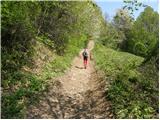 13
13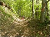 14
14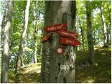 15
15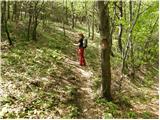 16
16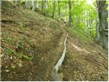 17
17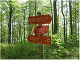 18
18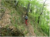 19
19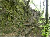 20
20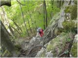 21
21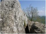 22
22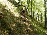 23
23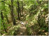 24
24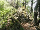 25
25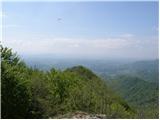 26
26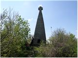 27
27
Discussion about the trail Prelaz Vrhe - Donačka gora
|
| petruša1. 03. 2010 |
Mene pa zanima kakšne so kaj razmere na Donački g. če še je kaj snega.
|
|
|
|
| šerpa1. 03. 2010 |
Takole je dva dni nazaj opisal stanje na forumu "stankoju":
"Ko sem prišel popoldan iz službe me je potegnilo lepo vreme in sem šel na krožno okrog Donačke g. in na vrh po zajlah.Pot je po južni strani večinoma kopna in ne preveč blatna na severni strani in proti Rudijevemu domu pa je na poti 10 do 15cm zbitega snega po katerem pridejo prav akrobatske sposobnosti da te ne spodnese, potrebna še je vedno previdnost."
lp
|
|
|
|
| mojcej'7227. 04. 2010 |
Danes dne 27.4.2010 je bila Donačka gora okupirana kot ljubljanska Šmarna gora, očitno je ljudi privabilo lepo vreme in dela prost dan. Dolžina hoje v verziji od zaselka Tlake se poveča še za 1h, če si z otrokom 7 do 10 let, pa še dodatnih 30 min.
Dalje na poti sami od Rudijevega doma do vrha je pot še zanimivejša, od ogromnih podrtih dreves, do kakšne veverice, opisa pragozda in zanimivih kamninskih plasti. Na vrhu pa celo zastava RS!
|
|
|
|
| Benjamin98320. 03. 2014 |
Kaj mi lahko kdo pove ce je zig na donacki? 
|
|
|
|
| pohodnik3820. 03. 2014 |
Na obeh vrhovih je....na vzhodnem je "malo"skrit pod skalo.
|
|
|
|
| balon20. 06. 2014 |
Zanima me ali bi del tega vzpona (klini) bil primeren za 5 letnico? MOram povedati, da ji kondicije ne manjka, bolj iz varnostnih razlogov. Hvala za odgovor. Balončki 
|
|
|
|
| garmont20. 06. 2014 |
Del z jeklenico ni prepaden. Malo popazi na to kam otrok stopa, pa bo. Kar korajžno.
|
|
|
|
| Stamp3. 04. 2022 11:38:45 |
Sa sjevera, iz smjera Kupčinji Vrh, nije opisan ni jedan smjer.. Mi smo se po jednoj stazi popeli, po drugoj spustili.. Lagano (osim ono malo sajle), kratko i slatko.. U Rudijevom Domu fini Grah i Ričet, i Bučnica. Opis puta, karta i slike na OVOM LINKU
|
|
|