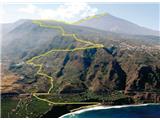
Playa del Socorro - Pico del Teide
Starting point: Playa del Socorro (0 m)
| Lat/Lon: | 28,3946°N -16,6017°E |
| |
Time of walking: 12 h
Difficulty: easy unmarked way
Altitude difference: 3718 m
Altitude difference po putu: 3718 m
Map:
Recommended equipment (summer): lamp
Recommended equipment (winter): lamp
Views: 6.120
 | 5 people like this post |
Access to the starting point:
We arrive on the island of Tenerife and continue to Playa del Socorro beach, where the route described above begins.
Path description:
The 0-4-0 route symbolises the ascent from sea level to 4000 m. a. s. l. , and the descent back. In fact, we are less than 300 metres from this altitude.
From Socorro beach, we start climbing up the steep asphalt road to the first junction with the motorway. At this point, bear right for about 100 metres, then turn left onto the dirt cart track, which turns into a cobbled road. At the first crossroads, just cross the street and turn left at the next one (Calle Tigaiga). Continue for another 300 metres, then at the junction with the chapel on your left, continue along Camino Vueltas de Icod El Alto to reach the main road TF342. Continue along the footpath to the Mirador el Lance viewpoint. The Mirador de la Corona lookout point is always clearly visible above us, with its many transmitters serving as a landmark as we pass by it. When we reach it, we will have a view of the summit. Here we leave the urban environment and start climbing up forest roads and paths. We are always walking upwards. There are NO SIGNS, but where there are, they point us towards other places that do not lead in our direction. When in doubt, we choose the path that is steepest. After a long walk through the forest, we climb above the tree line and enter a rocky plateau with sparse scrub. The view opens up again towards the volcanic cone. Continue along the path, turn left at the chapel and descend past a wooden fence to cross a sandy valley. Keep left. At the first crossroads, turn right on route 22 and follow it to route 7, and continue on this. When you reach the foot of the steep section, there is no doubt. Here, the path leading from the parking lot at around 2400 m joins the trail and the number of hikers on the trail immediately increases. We climb steeply towards the summit, past the Refugio Altavista (3250 m), until we reach the checkpoint (3550 m), where we have to show our permit and ID. Without this, we can only climb to the summit and descend back before 9 o'clock. At the top there is a beautiful view on all sides. There is steam from the hot rocks, the smell of sulphur and a large crowd of people who have come to the top by gondola.
Let's go down the same path.
WARNINGS:
- The summit itself requires a special permit (Permiso), which is free but must be obtained in advance (via the internet), as without it you will not be allowed on the summit. It is necessary to estimate the start time of the climb in order to arrive at the summit at the right time - the permit is valid for 2 hours! The route is not marked, which can increase the walking time.
- Although the route is technically easy, it is almost 30 km long and requires more than 3700 metres of ascent. Of course, you can shorten the walk and take the car, bus and gondola for part of the way.
- The gondola is also available for the descent into the valley (€27). There is also a bus from the lower gondola station into the valley, but be careful not to miss the last bus, which departs up to an hour before the last gondola ride. - On average, the temperature drops by about 25 degrees C on the way to the top, so make sure you are dressed appropriately. - Protect yourself from the sun and make sure you have plenty of water. If you have not pre-booked, do not count on the Altavista Hotel to offer you a deal or accommodation. Reservations are required for sleeping, and only a vending machine with snacks and drinks is available.

Pictures:
 1
1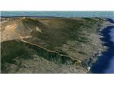 2
2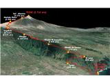 3
3 4
4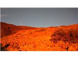 5
5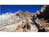 6
6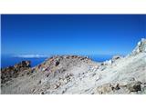 7
7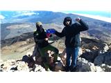 8
8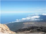 9
9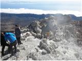 10
10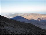 11
11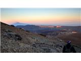 12
12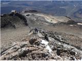 13
13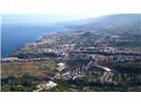 14
14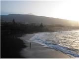 15
15
Discussion about the trail Playa del Socorro - Pico del Teide
|
| lino3. 02. 2016 |
Roklun, zelo zanimiv izlet na višino slabih 1000 metrov nad Triglavom. Po slikah sodeč je tura za pohodnike s planinsko dušo.
Ali je na sliki 8 zaščita na obrazu za puščavski zrak ali zavoljo mraza.
Na sliki 10 se tudi vidijo nekakšne meglice. Ali je to megla, prah ali pa celo žveplene pare ugaslega ognjenika.
Lep opis ture in zanimive slike. Lp
|
|
|
|
| ločanka3. 02. 2016 |
Tudi jaz sem se pred parimi leti povzpela na ta prekrasni vrh s prekrasno okolico. Na vrhu je bilo zelo mrzlo in vetrovno, vonjali smo žveplo. Vzpon smo pravili po daljši poti in prenočili, za spust smo pa koristili gondolo.
Vsakemu priporočam obisk tega vrha, saj brez tega dosežka ni pravega doživetja Kanarskih otokov.
|
|
|
|
| Bojan_A3. 02. 2016 |
Hvala za dobro idejo! Slovenija je že obdelana. Si želim videti še več opisov gora iz raznih turističnih in daljnih krajev.
|
|
|
|
| roklun4. 02. 2016 |
Lino, imaš prav, je kar močna tura. Ravno ta akumulirana višinska razlika, ki sva si jo zadala premagati v enem samem naskoku, me je tako navdušila, da sem napisal svojo prvo objavo za stran hribi.net, ki jo tudi sam rad obiskujem. Prav vesel sem pozitivnega odziva!
Kljub dobri kondiciji so me noge bolele še tri dni. Kolega je imel obraz zakrit bolj zaradi preventive, pred višinskim soncem. Bilo je precej vetrovno, temperatura pa pod lediščem - neprespana noč pa tudi pripomore k premraženosti. Prahu sva se nadihala na višini med 2000 in 2600 metri, kjer teče pot po peščeni podlagi in je veter razpihoval pesek na vse strani. Tiste meglice so pa res žveplena para ... Lp
|
|
|
|
| Pi_is_exactly_34. 02. 2016 |
Iz radovednosti sem malo brskal po novicah in našel članek, da je gorski tekač Agustí Roc leta 2013 (april) postavil rekord te poti. Prejšnji rekord je popravil za 40 minut, vzpon je opravil v 3h 33min. 
|
|
|
|
| roklun4. 02. 2016 |
Res je, tudi jaz sem to prebral. Kolega, s katerim sva lezla gor, preprosto ne more verjeti ... Nor čas - RES!
|
|
|
|
| lino4. 02. 2016 |
Roklun hvala. Res so impozantne številke od 0 do 3718 m nad morjem. Tudi za mene, ko občudujem ta opis doma na kavču, kaj šele v živo na terenu. Rekorder te poti je pa že bolj robot, kot pa človek. Tudi pokrajina je nekam skrivnostna, vabljiva. Me kar vleče tja. Tebi in prijatelju želim še mnogo tako vabljivih izletov. Lp!
|
|
|
|
| opazovalec27. 05. 2016 |
Ob branju Roklunovega poročila se marsikdo zaloti, da bi rad kaj takega poskusil tudi sam. Z ženo sva maja ponovno na Tenerifu in zaradi logistike, je ponovitev cele poti res težavna, saj se je vrniti zvečer v dolino nemogoče. Odločila sva se za prirejeno izvedbo od obale do vrha. Posadko sva razdelila na pol. Kolesarski del je začel s kolesom malo nad obalo, avtomobilski del se je premaknil na izhodišče iz najprimernejše točke na 2300m. Izposojeno kolo sva tako varno zaklenila v avto in jo mahnila na El Teide. Preudernejši avtomobilski del je kakih 200m pod vrhom zaradi viharja obračal, kolesarski del je šel skoraj po kolenih do vrha. Kapo mu je odpihnilo. Slika z vrha je tako lanska saj bi bilo letos slikanje nemogoče. Žičnica je nehala voziti že čez dan, zato najine "ne-dovolilnice" ni nihče preverjal. Za dokaz pristopa na vrh naj bo gps sled.
|
|
|
|
| DaKa24. 05. 2018 |
Rada bi opozorila vse, ki potujete preko agencije Zoja Challenge naj bodo previdni.Mi smo se vrnili s Tenerifov in imamo zelo slabe izkušnje. Tenerifi so pa zelo lep otok.
|
|
|