Planina Ravne - Dleskovec (by southern mountainside)
Starting point: Planina Ravne (1500 m)
| Lat/Lon: | 46,3493°N 14,6997°E |
| |
Name of path: by southern mountainside
Time of walking: 1 h 40 min
Difficulty: easy unmarked way
Altitude difference: 465 m
Altitude difference po putu: 465 m
Map: Kamniške in Savinjske Alpe 1:50.000
Recommended equipment (summer):
Recommended equipment (winter): ice axe, crampons
Views: 29.898
 | 2 people like this post |
Access to the starting point:
a) First drive to Kamnik, then continue to Stahovica and the Črnivec Pass. A few 100 metres before the Črnivec Pass, leave the main road leading to Gornji Grad and drive sharp left in the direction of the Volovljek Pass (Kranjski Rak). From the above-mentioned pass, continue straight ahead (on the left the road leading to Velika planina, on the right the Štajerski Rak) and start descending towards Luče. Lower down, the road bends slightly and leads to the Podvolovljek valley. Continue past the road leading to the Lučka Bela valley, then past the bar at Gams. After the bar, pay attention, because just a few 100 metres further on, a road branches off to the left, leading to mountain pasture Podveža and Ravne and the Planinšek farm (at the point where you leave the main road, the road marking is approximately 11 km). Continue along the initially still asphalted road, which climbs further towards the Dleskovská plateau. Higher up, the road to Planinšek branches off to the right, and here we continue along the upper road on the left, which leads us a little further to the next crossroads, where we continue straight on in the direction of mountain pasture Ravne (on the left mountain pasture Podveža). Continue on a slightly less favourable road, then follow to the start of mountain pasture Ravne, where you park in a suitable place on the roadside.
From the main road to mountain pasture Ravne is about 10 km.
b) First drive to Luce, then continue to Kamnik. When you see the road sign by the side of the road indicating 10,5 km, pay attention to the right fork, as just a little further on the road will branch off to the right towards mountain pasture Podveža and Ravne and the Planinšek farm. Continue along the initially still asphalted road, which climbs further towards the Dleskovški plateau. Higher up, the road to Planinšek branches off to the right, and here we continue along the upper left road, which leads us a little further to the next crossroads, where we continue straight on in the direction of mountain pasture Ravne (to the left mountain pasture Podveža). Continue on a slightly less favourable road, then follow to the start of mountain pasture Ravne, where you park in a suitable place on the roadside.
Path description:
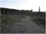
At the beginning of mountain pasture Ravne (also Ravni) we see wooden mountain direction signs for Velika vrh, Korošica, Molička peč or Molička mountain pasture and Dolgo Trata, which direct us to the left towards the nearby hut, which is located on the edge of mountain pasture. Go around the hut on the left and then into the narrow lane of a forest, where signs lead you to the left. The path ahead leads through a clearing, over which it climbs crosswise into the forest. Continue climbing through the forest, soon crossing a grazing fence. Higher up, the forest begins to thin out, or change into lane of dwarf pines. In a few places, the slightly less well-beaten but still well-traced path climbs higher and leads to the lower edge of the Dolgi Trata pastures. Here the path is fully laid and in a few 10 steps of further walking leads us to the shepherd's hut at Dolgi Trata.
At the shepherd's hut, where there is a small marked crossroads, continue to the right in the direction of Dleskovec (to the left Molička mountain pasture, Velika vrh and Korošica). The unmarked trail then passes a nearby cross on the left and becomes dwarf pines through which it starts to climb moderately. From the cross onwards, follow the beaten and partly mown path for a while, then, when it is laid and leads to a small sinkhole, it suddenly disappears almost completely. Here we continue along the left side of the sinkhole and climb between dwarf pines on the left and the scrotum on the right. The steep part ends quickly and the "path" then leads quickly to a viewpoint.
Planina Ravni - Dolga Trata 1:15, Dolga Trata - Dleskovec 25 minutes.

Pictures:
 1
1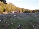 2
2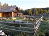 3
3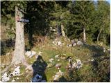 4
4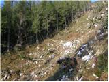 5
5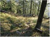 6
6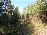 7
7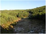 8
8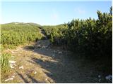 9
9 10
10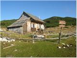 11
11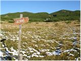 12
12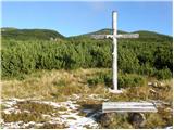 13
13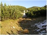 14
14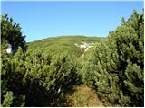 15
15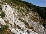 16
16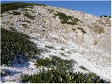 17
17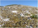 18
18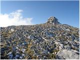 19
19
Discussion about the trail Planina Ravne - Dleskovec (by southern mountainside)
|
| fpetel115. 10. 2008 |
Pot iz Raven je široka in lahko sledljiva. Poleg dvojnih rdečih črt, ki razmejujejo parcele, so marsikje vidne stare merkacije, ki vodijo na Sedelce. Proti vrhu (šel sem iz vrha) Dleskovca gre pot nekaj časa med rušjem, kar nas pretirano ne ovira, ker je pot še kar široka in prehod ne traja predolgo.
|
|
|
|
| grega_p13. 09. 2009 |
V prijetni družbi sem opravil delno nočno turo po opisani poti, kar je tudi svojevrstna dogodoviščina. Še posebej zato, ker nisem bil ravno prepričan v stanje poti (obilo rušja in ostalih manjših stezic). Kakorkoli že, po uri sopihanja pod nešteto zvezdami in zanimivimi nočnimi zvoki sva prilezla do Dolgih Trat, kjer sva v sobici zasilno prenočevala (en ogromen hvala lastniku/oskrbniku-za priboljšek je ostala čokolada) in naslednji dan ob megli in soncu (samo, da se je videlo:-) med rušjem nekako osvojila Dleskovec. Res, treba je biti pozoren in rahlo pogumen, ko se od koče vzpenjamo ob grapi, saj pot ni čisto lahko sledljiva. Pa obvezno na levo na manjšem sedelcu, jaz sem izbral desno in osvojil še neki "mali" kucelj z možicem na vrhu.
Če sestopate na severno stran pa bo tudi potrebno nekaj iznajdljivosti preden dosežete markirano pot iz pl. Ravne. Malo po občutku, malo pa tudi v počepu skozi rušje.
Ja, ob pogledih na to pokrajino tam gori ni težko izjaviti, da je nekaj posebnega na tem visoko-kraškem območju Kamniških alp. Še pridemo.
Grega in Anja
|
|
|
|
| Rokovnjacica11. 08. 2014 |
Bila sem na Dleskovcu po zgoraj opisani poti. Tudi jaz sem osvojila najprej desni vrh (kot Grega)in s tega manjšega vrha sem hitro opazila ta pravega in se povzpela še nanj. Razgledi so res lepi, poti vabljive, tako, da bom gotovo kmalu spet prišla v štajerske konce.
|
|
|
|
| ločanka3. 05. 2019 |
Včeraj na tej poti. Res čudovit izlet. Se splača narediti krožno turo, da se čez vrh spustiš proti Sedelcu in se vračaš po severnih pobočjih. V tem času je po teh pobočjih še sneg. Najbolje, da hodiš po stopinjah predhodnika  Seveda, če imaš srečo
|
|
|