Planina Blato - Kreda (via Slatna)
Starting point: Planina Blato (1147 m)
| Lat/Lon: | 46,3112°N 13,8501°E |
| |
Name of path: via Slatna
Time of walking: 3 h 20 min
Difficulty: easy pathless terrain
Altitude difference: 878 m
Altitude difference po putu: 950 m
Map: Triglav 1:25.000
Recommended equipment (summer):
Recommended equipment (winter): ice axe, crampons
Views: 13.348
 | 3 people like this post |
Access to the starting point:
From the Ljubljana - Jesenice motorway, take the Lesce exit and follow the road towards Bled and on to Bohinjska Bistrica. Continue towards Bohinjsko jezero (Ribčev laz), at which you will come to a crossroads where you will turn right towards Stara Fužina. At Stara Fužina, at the crossroads by the chapel, turn sharp left onto the ascending road towards mountain pasture Blato, mountain pasture Vogar and the Voja valley. The road continues to the place where the toll and parking fees are collected, and we follow it to the next crossroads, where we continue to the left (right Voje). We then follow the road to the next crossroads (we drive for some time), where we take a sharp right in the direction of mountain pasture Blato (straight ahead mountain pasture Vogar). Follow this road to the parking lot above mountain pasture Blato.
Path description:
From the parking lot at mountain pasture Mud, follow the road back a little to the signs at cart track. Here we take the cart track, which climbs steeply at first and then moderately, and within ten minutes' walk leads us to a crossroads, where we turn left (straight mountain pasture in Laz). Cart track is then followed through the forest to the hut at mountain pasture at Jezero. Here you will have a view of the surrounding mountains.
Go around the mountain hut on the left and the path leads us in a slight downhill to a crossroads where we continue straight along cart track (to the left mountain pasture Viševnik). The mostly rocky cart track, which follows an unmarked valley, climbs steeply a few times and, after half an hour's walk from mountain pasture at Jezero, leads to mountain pasture Dedno polje, where you reach the next crossroads. Here you leave the broad path leading to the hut by the Triglav Lakes. Continue to the right (direction Vratca Preval, Hribarice and Prehodavci), initially slightly downhill past shepherd's huts to the above-mentioned mountain pasture. On the other side of mountain pasture the path starts climbing again and leads to a less visible crossroads where the path branches off to the right to mountain pasture in Laz. Continue straight up the path, which gradually starts to climb more steeply. The path, which takes us past the animal watering point (the watering point is dry), climbs mostly through coniferous forest (larch and spruce). After about half an hour's walk from mountain pasture, the world flattens out and we have a fine view of the peaks that surround the initial part of the Za Kopica valley. After a few easy steps, you will see a path that veers off the marked path to the right (mogizi) and crosses the scree uphill. The path from the scree slope changes to a grassy slope, after which you will come to a small, indistinct precipice. Here the path is lost for a short time, but in good weather we will have no problems with orientation. The trail continues to climb through an increasingly narrow valley, passing between První Vogl on the left and Slatna on the right. This sometimes quite steep path is then followed to the saddle between the two peaks. Here the trail finally disappears and we continue to the right, where we reach the top of the panoramic and vast Slatna in 10 minutes on a gentle and grassy slope. From Slatna continue ahead (direction southeast) along the slope, which begins to descend gently. The "path" we are walking on leads us into a small valley, which gradually narrows. When the slope widens again, the 'path' stops descending and a beautiful passage opens up in front of us, which we follow to the foot of the Chalk. There is only a 5-minute moderate climb to the summit.
In the fog, orientation on the path is difficult.
Blato - Dedno polje 1:30, Dedno polje - Slatna 1:30, Slatna - Kreda 20 minutes.

Pictures:
 1
1 2
2 3
3 4
4 5
5 6
6 7
7 8
8 9
9 10
10 11
11 12
12 13
13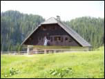 14
14 15
15 16
16 17
17 18
18 19
19 20
20 21
21 22
22 23
23 24
24 25
25 26
26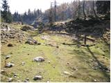 27
27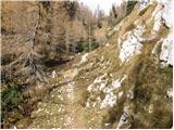 28
28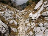 29
29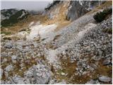 30
30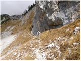 31
31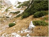 32
32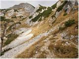 33
33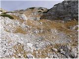 34
34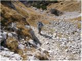 35
35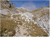 36
36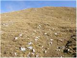 37
37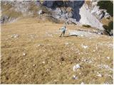 38
38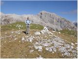 39
39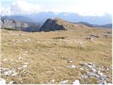 40
40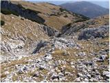 41
41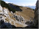 42
42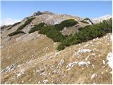 43
43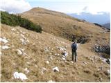 44
44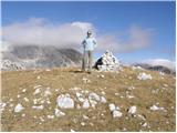 45
45
Discussion about the trail Planina Blato - Kreda (via Slatna)
|
| lukk23. 06. 2014 |
Kdo ve kakšne so kaj razmere
|
|
|
|
| lukk23. 06. 2014 |
hvala sam e bo slabo vidi ker so črno bele
|
|
|
|
| Daaam23. 06. 2014 |
Kva pa bi rad?...imel roza sneg, pa modro travo?
|
|
|