Parkplatz Erichhütte - Hochkönig (Königsjodler)
Starting point: Parkplatz Erichhütte (1339 m)
| Lat/Lon: | 47,39164°N 13,04879°E |
| |
Name of path: Königsjodler
Time of walking: 7 h 45 min
Difficulty: extremely difficult marked way
Ferata: D
Altitude difference: 1602 m
Altitude difference po putu: 1900 m
Map:
Recommended equipment (summer): helmet, self belay set
Recommended equipment (winter): helmet, self belay set, ice axe, crampons
Views: 8.634
 | 4 people like this post |
Access to the starting point:
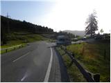
Drive through the Karavanke Tunnel into Austria, then continue along the Tauern motorway. We continue through the Katschberg Tunnel and later the Thuringian Tunnel / Tauerntunnel, and follow the motorway to Salzburg (aka Solnograd) only as far as the exit for Bischofshofen, from where we continue on the four-lane road to the aforementioned town. From Bischofshofen follow the signs for Höchkonig and Dienten am Höchkonig. The road starts to climb and leads to the Dientner sattel. From the saddle, continue for another 100 metres along the road, which begins to descend, and then you will see a parking area on the right-hand side of the road where you park.
Path description:
From the parking lot, follow the signs "Erichhütte 30 min" to the mountain road, which is closed to traffic. The macadam road we are climbing leads us along pastures with a beautiful view of the High Tauern and the nearby peaks above the Erichhütte hut. The path then leads us through a short lane of forest where we also cross a small stream. The path continues along the pasture again until it reaches the Erichhütte hut on the mountain pasture Schönbergalm.
From the hut, continue to the right, following the signs "Königsjodler Klettersteig, Hochkönig", and start to climb gently up the grassy slopes to the north-east. The path soon leads to a crossroads where you continue left in the direction of Hochkönig, and to the right the path leads to the summit of Taghaube (2159 m).
The trail then climbs for a while along the rare dwarf pines, and then along a slightly steeper grassy slope leads to another crossroads. A protected climbing route to the right leads to Granlspitz (2307 m), and we continue left towards the Hochscharte notch.
Here the path turns slightly to the left and leads from the grassy slopes to steeper rocky slopes, which are initially traversed to the north. After crossing, the path turns to the right and climbs up to the Hochscharte notch. The path is quite rough at this part and a short ladder is helpful, but the path is not particularly difficult here. Continue left on the notch and after a short climb you are back at the crossroads. To the right, the slightly easier route No 432 branches off, leading to the Birgkarscharte ridge and on to Hochkönig or Hoher Kopf. We continue to the left and the path quickly leads to the entrance to the Köngsjodler protected climbing route.
Before entering the climbing section, equip yourself with a helmet and self-belay gear, and it is recommended to wear climbing gloves.
In the initial part of the route, the path climbs steeply along a ropeway towards the ridge to a tower called the Flower Tower. The path then follows a slightly exposed ridge and then climbs steeply. The ridge then gives way to the left side and you cross a steep wall towards a narrow notch (difficulty C/D). Cross the narrow notch using a rope to the other side and then climb steeply towards the Teufels Turm Tower (difficulty C). From the tower, you then descend steeply (difficulty C/D) and cross the notch below you on a suspension bridge. The bridge is made of three cables, one of which you walk on and the other two are used for holding and self-belaying. There is a short traverse of steep walls and a steep descent with a few scrambles to help (difficulty C). After the descent, the path leads to a slightly less exposed and unprotected part of the route. After a short climb, the route is secured again and there is a climb up a still slightly less sharp ridge, which leads to the next tower (difficulty B/C). There is a short descent and then, with the help of just one rope (Flying Fox), which is led to the next tower, we cross the notch below us. If you do not have the right equipment for such a crossing, you can also continue along the route that descends into the notch. It is recommended to use a double pulley with a rope to cross the notch. With some care, it can also be crossed with an additional umbilical. On the other side of the notch, there is another slightly less steep climb along the sheave. The route soon leads back to an exposed ridge (Teufels Hörndl). After a few short ascents and descents (difficulty C), there is a slightly steeper climb up to a sharp, extremely exposed ridge (difficulty C/D). There are also a few crampons to help you climb up. There is a short climb up the ridge, followed by a descent into the stubble. A slightly less steep path then leads to a crossroads where an emergency exit is possible down to the right. The path to be followed is technically less difficult, but the steepness and the sparsely measured fixed safety gear require some caution.
At the crossroads where we are about halfway up the protected climbing route, we continue straight ahead and climb up the less steep unprotected slope, which leads us to one of the more difficult parts of the route. There is a fairly long, mostly vertical climb (difficulty D) to the next tower, called Kummetstein. There is also a risk of falling rocks on this part of the route. Just below the top of the tower, there is a registration box along the way. There is another short descent along the ridge from which we have increasingly beautiful views, especially towards the Hochkönig summit. The path leads us to the next stub and the ridge recedes to the left. Another very steep climb (difficulty D) follows, with a few staples to help us. When we reach the ridge again, the route becomes slightly less difficult for a while (difficulty A/B). There is one last steeper climb (difficulty C/D), and then the route becomes progressively less difficult and leads us to the top of Hoher Kopf where the protected climbing route ends. At the top, there is also a fine view north towards the glacier and the other mountains of the Berchtesgaden Alps, which are located on the German side of the border. From the summit, continue right towards the Hochkönig summit, which can be seen ahead. First descend slightly to the stub Birgkarscharte where there is a crossroads.
Continue straight on at the stub, and down to the right is route 432 back to the starting point. From the stub, the trail first climbs slightly and then descends slightly again. When you reach the base of the slopes of Hochkönig, the path climbs steeply and a view of a large part of the glacier below the slopes of Hochkönig begins to open up. The path, which is marked with red and white pegs, leads us up a slightly steeper slope to a crossroads on the north side of the summit. At the crossroads, continue right and there is only a short, easy climb to the summit.
The route described is extremely difficult and is suitable only for experienced mountaineers with the obligatory self-belaying and sufficient strength in their arms. The route is very long, so you need to be in good condition.
You can descend back to the Birgkarscharte stub and then down the 432 route. Great care is needed on the descent as the path is very crumbly and quite poorly protected. The climb then ascends gently towards the Hochscharte where the Königsjodler route starts. From there, descend past the Erichhütte hut back to the starting point.
It is also possible to descend by an easier but much longer route past the Arturhaus hut.

Pictures:
 1
1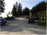 2
2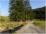 3
3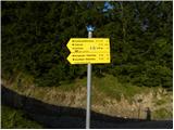 4
4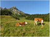 5
5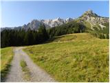 6
6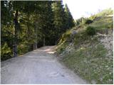 7
7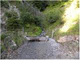 8
8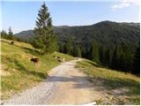 9
9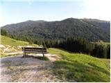 10
10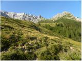 11
11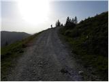 12
12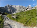 13
13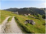 14
14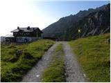 15
15 16
16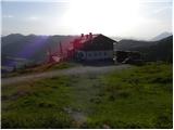 17
17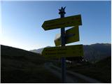 18
18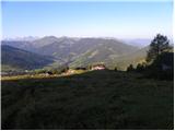 19
19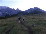 20
20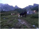 21
21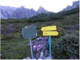 22
22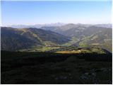 23
23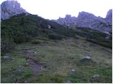 24
24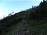 25
25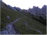 26
26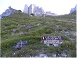 27
27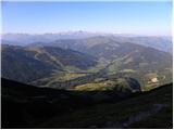 28
28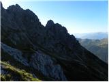 29
29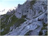 30
30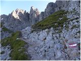 31
31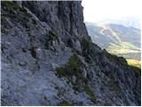 32
32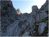 33
33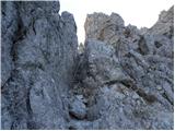 34
34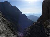 35
35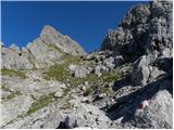 36
36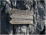 37
37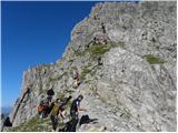 38
38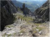 39
39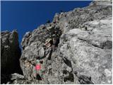 40
40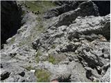 41
41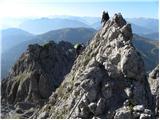 42
42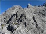 43
43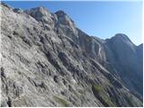 44
44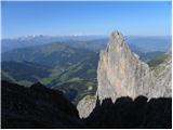 45
45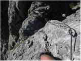 46
46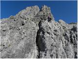 47
47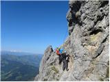 48
48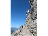 49
49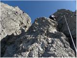 50
50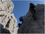 51
51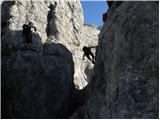 52
52 53
53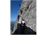 54
54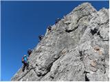 55
55 56
56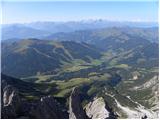 57
57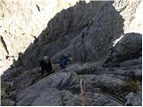 58
58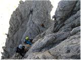 59
59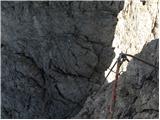 60
60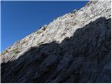 61
61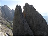 62
62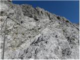 63
63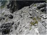 64
64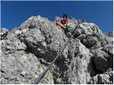 65
65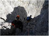 66
66 67
67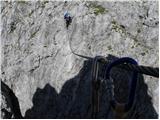 68
68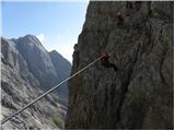 69
69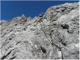 70
70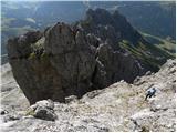 71
71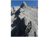 72
72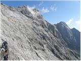 73
73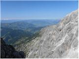 74
74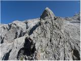 75
75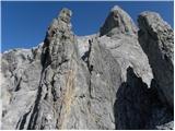 76
76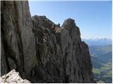 77
77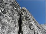 78
78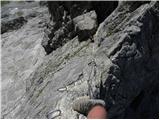 79
79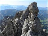 80
80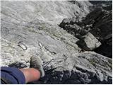 81
81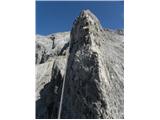 82
82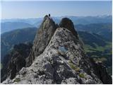 83
83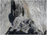 84
84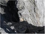 85
85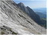 86
86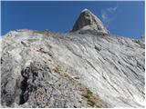 87
87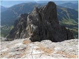 88
88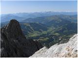 89
89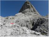 90
90 91
91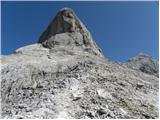 92
92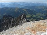 93
93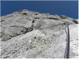 94
94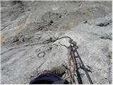 95
95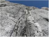 96
96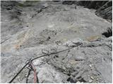 97
97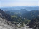 98
98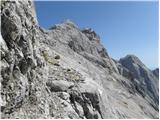 99
99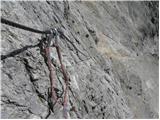 100
100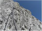 101
101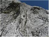 102
102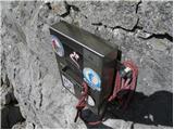 103
103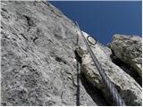 104
104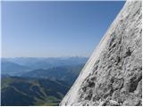 105
105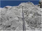 106
106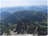 107
107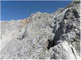 108
108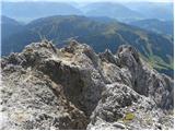 109
109 110
110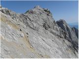 111
111 112
112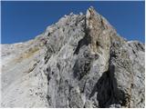 113
113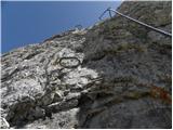 114
114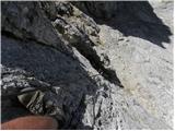 115
115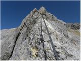 116
116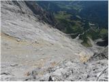 117
117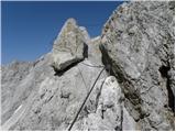 118
118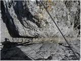 119
119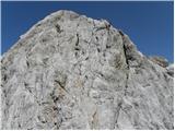 120
120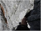 121
121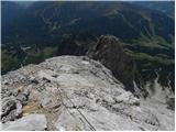 122
122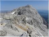 123
123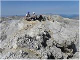 124
124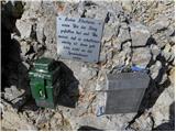 125
125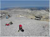 126
126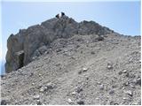 127
127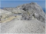 128
128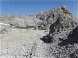 129
129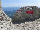 130
130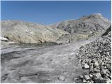 131
131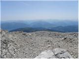 132
132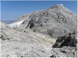 133
133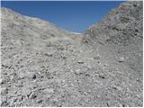 134
134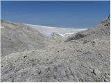 135
135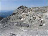 136
136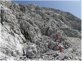 137
137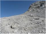 138
138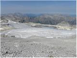 139
139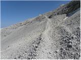 140
140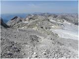 141
141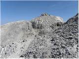 142
142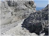 143
143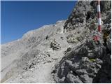 144
144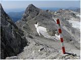 145
145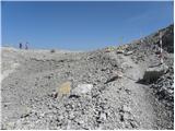 146
146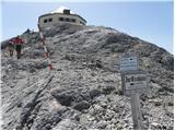 147
147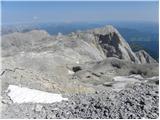 148
148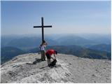 149
149 150
150
Discussion about the trail Parkplatz Erichhütte - Hochkönig (Königsjodler)
|
| gapo23. 08. 2012 |
včeraj smo trije preplezali tole farato. opis je točen, parkirišče se nahaja nekje 300 metrov desno od vrha prelaza ( če prideš v temi da ne iščeš). Ferata ni kdo ve kaj tehnično zahtevna (OSEBNO MNENJE) je pa precej dolga in sam dostop do začetka plezalnega dela že vzame kar nekaj moči. Potrebno je imeti precej vode ker do koče, ki se nahaja na vrhu ni druge možnosti po vodi kot stopljen sneg pa še to šele povsem pod vrhom. Za sam vzpon se potrebuje nekje 2 uri do vstopa v plezalni del in potem še vsaj 4 ure plezarije do vrha (nekje po dveh tretjinah in ne na polovici plezalneg dela je možen izhod v sili oz.predčasn sestop) in pa tri ure od vrha zoprnega strmega sestopa po šodru ( prijatelj se je malo zakotali a nič resnega)...tu bi bilo mogoče smiselno vendarle ubrati daljšo pot preko koče Arturhaus kot opisuje avtor v prispevku. Tura naporna predvsem tudi ker se do izhodišča iz Slovenije ( Lesce) peljaš kar dobri dve uri tako da je treba od doma ob tem letnem času vsaj ob 3.30 zjutraj ( mogoče bi bilo smiselno prespati nekje v bližini). Lahko pa se prespi tudi v koči na vrhu ( vzorno urejena, lepe sanitarije, sobe, imajo celo pralni stroj). Predhodnoi bi bilo smiselno rezervirati in se na dan prihoda pojaviti do 17 ure ko držijo rezercacijo. Cene v koči zmerne, pivo 3,7EUR. Skratka precej kondicije in vode pa cel dan časa 
|
|
|
|
| nataša123. 08. 2012 |
Gapo - kapo dol!!! Res ste v izredno dobri psihofizični kondiciji. Že ob gledanju fotk sem začutila močan adrenalinski val... kaj bi šele bilo tam??!! Zanima me tvoj občutek, ko si se spustil čez prepad z varianto Flying Fox? Ali si je potrebno pomagati tudi z rokami ali se samo spustiš in pristaneš pri steni? Še enkrat čestitke vsem trem in veliko užitka pri nadaljnih podvigih.
|
|
|
|
| gapo23. 08. 2012 |
dva sva se spustla s škripcem ki je bil premajhen (zajla je precej močna) zato ni teklo tekoče in je blo treba z rokami precej pomagat, kolega je šel čez samo s karabinom vpetim na pas ampak je treba isto z rokami vlečt - je pa to boljša varianta.
če si že bila v kakšnem adranalinskem parku ti ta prehod ne bo delal težav če pa se bojiš pa greš lahko spodaj in se izogneš spustu.
|
|
|
|
| vanja123. 08. 2012 |
Zdaj, ko je big G. že napisal skoraj vse, bom kot soudeleženec le nekaj stvari dodal.
Pot je res zahtevna zaradi dolžine. Nisem v formi kot big G., čisto zakrnel pa tudi ne, pa je bila zadeva zelo na robu mojih zmožnosti. Zadnji vzpon proti koči sem šel kot zombi.
VELIK PROBLEM je tekočina, sam sem jo za pot gor in dol pogoltnil 8 litrov. Pri tem je potrebno upoštevati, da je ledeniška voda na voljo šele na koncu ferate.
Moj Timex GPS je naračunal 2500 višinskih metrov vzpona (vključno s sestopom).
Komur so tako kot meni ferate izziv zaradi plezanja, naj gre raje 3x na Dachstein. Bo precej bolj zadovoljen.
Zgovoren je namreč že podatek, da je do vstopa v ferato dobri dve uri štamfanja in 1100 višincev.
|
|
|
|
| nataša123. 08. 2012 |
Sem si ogledala še filmček. Ne morem verjet kje so speljali smer??!! Vse čestitke tudi tovrstnim strokovnjakom, ki se zelo trudijo, da bi bilo čimbolj zaje.... Potem pa še problem vode!? Zame ste res pravi Junaki.
Menim, da po takšnem podvigu nisi več isti, saj izkustveni upground ni tko majhen. Fantje kaj pravite?
|
|
|
|
| vanja123. 08. 2012 |
Fantje pravmo, da bi kako punco nucal za družbo !
|
|
|
|
| gapo23. 08. 2012 |
Jo pa vzamemo naslednjič z sabo....
|
|
|