Markova raven - Mokrica (marked way)
Starting point: Markova raven (980 m)
| Lat/Lon: | 46,2969°N 14,5618°E |
| |
Name of path: marked way
Time of walking: 3 h 30 min
Difficulty: easy marked way
Altitude difference: 873 m
Altitude difference po putu: 1100 m
Map: Kamniške in Savinjske Alpe 1:50.000
Recommended equipment (summer):
Recommended equipment (winter): ice axe, crampons
Views: 12.693
 | 1 person likes this post |
Access to the starting point:
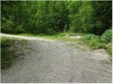
Drive into Kamnik and follow the road towards the Kamnik Bistrica valley. Just a few tens of metres before the bottom station of the pendulum at Velika planina, a forest road branches off to the left down into the Korošice valley. Take this road, which first descends, then crosses a bridge and leads us a little further on to a crossroads, where we continue straight ahead. Just a little further on, you come to the next crossroads, where you continue straight on again (possibly left - circular road). Follow this gradually steeper road, which is joined by another dirt road on the right (this is the road you would have reached if you had continued right immediately after the bridge), to level Markovo, which is identified by a small parking area, a stream and a wide cart track heading up to the left, and the road starts to descend steeply.
Path description:
From the parking lot, take the wide cart track road, which after a few dozen metres leads to the next parking lot. Continue straight across the parking lot and continue up the cart track, which turns left. After a few minutes' walk, cart track has a crossroads where you take the marked cart track to the right. Follow this for a few minutes to where the footpath to Krvavec and mountain pasture Koren branches off to the right. The branch is not marked so you have to follow the signs carefully. The path continues up the right side of the torrent quite steeply. The path then leads us to a crossroads where we continue to the right in the route ZA VRATA. The way forward slowly passes into a less dense forest, so that we sometimes cross a small meadow or even a short scree slope. The views are also getting better. Next, the path leads us under the foot of a shorter wall from which an unmarked path branches off to the right up to mountain pasture Koren. Continue slightly up the left side of the wall. The path ahead descends gently and leads to a pleasant small spring. The path continues to the left side of the small spring and starts climbing again. The path then crosses a short lane of dwarf pines and then starts to climb on grass. Further on, the path is more difficult to follow as it quickly gets lost in the grass but the markings, which are more sparse, will help. After 20 minutes of climbing from the well, the path leads us to a wooden house. The path behind the cottage turns left into the forest and after a short climb joins the path with Kriška planina (Krvavec). Continue sharp right and without a significant ascent or descent cross the lane of the forest. Further on, the path starts to climb up slopes covered with dwarf pines and a few trees. After 20 minutes of ascent, the steepness eases and the shepherd's hut at mountain pasture Koren can be seen ahead. The path then descends past a watering point for animals to a shepherd's hut at mountain pasture.
Here our route continues slightly left (slightly right mountain pasture Košutna) through the meadows on the valley flor (the path is initially not very visible). The path then becomes steeper and steeper and after less than 30 minutes of walking leads us to a small puddle where there is a less well marked crossroads. Continue straight ahead (right Košutna) and follow the gently sloping path to the next crossroads, where you continue along the right path in the direction of Kompotela (left Vrh Korena). From here on, the orientation is a little more difficult in the fog, but very difficult. The way forward slowly begins to climb gently on a grassy slope covered with dwarf pines. The path then leads us to the top of Kompotela in beautiful views.
Just a few steps from the summit, the marked path to Mokrica branches off to the east. Take this path as it begins to descend. After a good ten minutes of descending on steep grass, the path leads to the ridge of Mokrica. The path, which continues to descend gently, is slightly exposed in a few places. After a half hour's walk from Kompotela, the path leads us to a registration box at the top of Mokrice.
PP: In the fog, orientation is very difficult, especially from mountain pasture Koren onwards.
Markovo level - mountain pasture Koren 2:00, mountain pasture Koren - Kompotela 1:00, Kompotela - Mokrica 30 minutes.

Pictures:
 1
1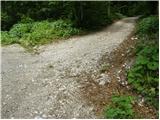 2
2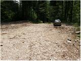 3
3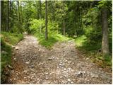 4
4 5
5 6
6 7
7 8
8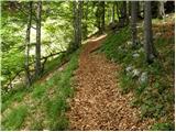 9
9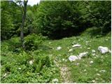 10
10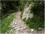 11
11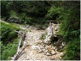 12
12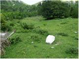 13
13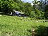 14
14 15
15 16
16 17
17 18
18 19
19 20
20 21
21 22
22 23
23 24
24 25
25 26
26 27
27 28
28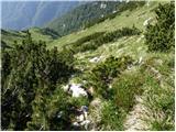 29
29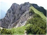 30
30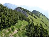 31
31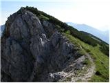 32
32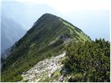 33
33 34
34 35
35
Discussion about the trail Markova raven - Mokrica (marked way)
|
| fpetel115. 06. 2011 |
Lep hrib in lep izlet.
Lepša perspektiva je neoznačena pot do mokriške jame in naprej po brezpotnem travnem terenu (iščemo ostanke poti in najlažji prehod)na vrh Mokrice. Vrnemo se po označeni poti čez Kompotelo. Markirana pot je kljub markacijam orientacijsko zahtevna, ker je med rušjem tudi nekaj neoznačenih odcepov poti in ovčjih stezic.
|
|
|
|
| rok.si14. 11. 2011 |
Pazite pri hoji po gozdni cesti od Markove ravni - nekaj kilometrov po razpotju iz četrte slike gozdna cesta v ostrem ovinku prečka suh hudournik, tu je potrebno iti ob hudourniku in ne po cesti - markacija se skriva globoko med drevesi na levi strani hudournika in jo je kaj lahko spregledati.
|
|
|
|
| HMatjaž4. 12. 2024 10:36:45 |
Živjo, Ali ima kdo info ali je cesta na Markovo ravan prevozna?
|
|
|
|
| bos5. 12. 2024 08:57:53 |
Ne verjamem, glede na stanje maja Mokrica.
|
|
|
|
| redbull10. 12. 2024 04:57:01 |
Ne more biti . Pri Kraljevem hribu le malce naprej po cesti je konkretno utrgano. Sanacija ne bo enostavna. Tako je bilo pred mesecem dni, ko sem se vračal iz Planine Koren ravno tukaj dol. Ceste ni bilo konec , bi rekel da sigurno 7km  Srečno
|
|
|
|
| matic415. 12. 2024 20:02:08 |
Cesta je prevozna preko Predaslja in Brsnikov, tam nekje do peskokopa, naprej do Markove ravni je bolj za peš. Če želiš peš od spodnje postaje žičnice (Kraljev hrib), potem greš še ene 50m v smeri proti Stahovici po asfaltu do smerokaza in potem desno po hribu navzdol, čez most in naprej čez Brsnike. Cesta po dolini Korošice pa ni prehodna.
|
|
|
|
| HMatjaž16. 12. 2024 13:34:40 |
Hvala za info, šel preko Brsnikov do peskokopa in nato po lovski gor.
|
|
|