Javorje - Rodica (marked way)
Starting point: Javorje (1050 m)
| Lat/Lon: | 46,2496°N 13,8675°E |
| |
Name of path: marked way
Time of walking: 2 h 45 min
Difficulty: easy marked way
Altitude difference: 916 m
Altitude difference po putu: 916 m
Map: TNP 1:50.000
Recommended equipment (summer):
Recommended equipment (winter): ice axe, crampons
Views: 92.615
 | 3 people like this post |
Access to the starting point:
From the Ljubljana - Jesenice motorway, take the Lesce exit and follow the road towards Bled and on to Bohinjska Bistrica and Lake Bohinj. After Laški Rovt you will reach a small crossroads where the road to the left branches off and leads to the starting points of the route to Rodica, mountain pasture Suho, Šijo, Vogel. . . and the Laški Rovt camping area. The dirt road immediately turns into a forest and first climbs past the above-mentioned camping area and then climbs relatively steeply for a few kilometres. After a little less than 6,5 km of macadam, you will reach a slightly larger crossroads where the road to the right branches off towards mountain pasture Storeča raven (the starting point of the route to Vogel). Continue straight on here and after about 50 m of further driving you will reach a left turn where the starting point of the route towards mountain pasture Suha. Park in a suitable place on the roadside.
Path description:
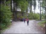
Near the parking lot, on the west side of the torrent, there is a marked footpath leading to mountain pasture Suha. The path initially climbs up the right-hand side of the torrent before joining it. After a few steps along the torrent, the marked path turns to the right and lays completely flat. The gently sloping walk is quickly interrupted by a steep ascent over a relatively steep slope. The steepness then eases a little and the well-marked path then leads up through the dense forest along and along the torrent. A little higher up, the marked path leaves the stream to the left and rejoins it after a few minutes. The path then runs along the right side of the torrent and soon leads us out of the forest onto the vast mountain pasture of Suha.
From mountain pasture continue past the shepherd's hut along the torrent gravel deposit. The path, which is sometimes very faint, turns slightly left at the top of mountain pasture. Further on, the path, which begins to turn slightly to the right, is much easier to follow. After a short climb, pass a hunting lodge, which can be seen on the right.
The path then begins to climb steeply up the slope, which is partly covered with dwarf pines. This increasingly scenic route, however, leads us higher up to the slightly larger cairn, where there is a crossroads (straight marked path to the Čez Suho saddle, left unmarked path over Lepo Suho).
Continue straight on the marked path climbing between dwarf pines and sparse trees. Higher up, the trees run out and the path reaches a sink below the saddle Čez Suho. The path goes around it on the left and soon afterwards leads to a crossroads at the saddle Čez Suho. Here stands an old military bunker with signposts.
We turn left onto a wide grassy ridge. The way forward here is not steep but has a few short descents. Soon the scenic route leads us to the top pyramid of the Rodica lookout.
Javorje - Suha 1:00, Suha - Čez Suho 1:00, Čez Suho - Rodica 45 minutes.

Pictures:
 1
1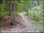 2
2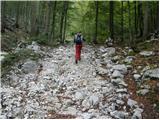 3
3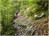 4
4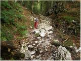 5
5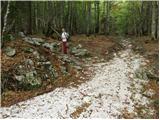 6
6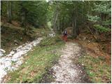 7
7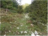 8
8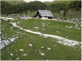 9
9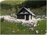 10
10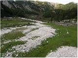 11
11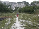 12
12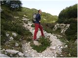 13
13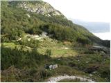 14
14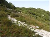 15
15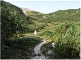 16
16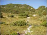 17
17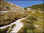 18
18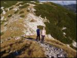 19
19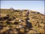 20
20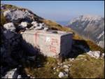 21
21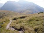 22
22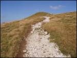 23
23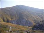 24
24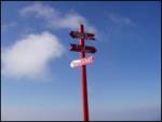 25
25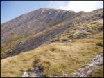 26
26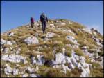 27
27 28
28
Discussion about the trail Javorje - Rodica (marked way)
|
| Parkeljc29. 09. 2009 |
Včeraj bil gor. Vzpon je primeren tudi za neizkušene, pa vendar je dobro imeti vsaj malo kondicije. Pot do Suhe skozi gozd, šel tam postane zanimiva, lepa pa šele na sedlu. Pogled proti Alpam je bil slab, čeprav je bilo skoraj jasno vreme, proti vzhodu pa je bila vidljivost praktično nična. Škoda, mogoče smo bili gor prepozni. Sestopil proti Suhi po bližnjici, nemarkiranaa pot. Najprej sestopaš po grebenu gledano v smeri Vogla, nato se pot razgubi, a nadaljujemo v grapo proti ruševju, kjer se dobro uhojena pot spet pokaže. Za tiste z nekaj kondicije priporočam nadaljevanje poti po bližnjih vršacih do Črne prsti.
|
|
|
|
| Rokoko24. 11. 2010 |
Z avto se pride visoko, brez težav do konca lepega makadama (kar se splača, ker pot skozi gozd ni kaj posebnega). Do Suhe gre več ali manj po suhem. Potem se začne sneg, kakšnih 30cm. Od Suhe navzgor je sneg skorjast, a ravno toliko, da se predira. Izbrali levo pot (nemarkirana, pri skalnatem možicu, ki se v snegu zelo slabo vidi zavoj levo namesto naravnost, vsaj 30 minut krajša kot po grebenu vendar manj razgledna), vendar prišli samo do sedla. Hoja postala proti sedlu naporna, ker se je vdiralo čez kolena. Gotovo bi šlo lažje, če bi posijalo sonce.
|
|
|
|
| ZOJA27. 04. 2011 |
Konec tedna bi se odpravili na Rodico po omenjeni poti. Kakšna je pot, je kaj snega, ali je koča na Suhi odprta s prvim majem? Že vnaprej lepa hvala za informacije.....lp
|
|
|
|
| ZOJA30. 04. 2011 |
a res ni nobeden te dni hodil po Rodici?
|
|
|
|
| Klin30. 04. 2011 |
Na severni strani Rodice je še kar nekaj snega.
|
|
|
|
| ZOJA30. 04. 2011 |
Hvala Klin, torej ne priporočaš vzpona brez zimske opreme?
|
|
|
|
| vavtora10. 05. 2011 |
jas bi tudi rada sla na rodico, katero pot mi priporocite brez zimske opreme?
|
|
|
|
| dore11. 05. 2011 |
Mislim, da je brez snega pot iz Grantarskega gozda. Je pa malo daleč do izhodišča.
|
|
|
|
| sunshine21. 06. 2011 |
Ali je kdo v zadnjem času hodil po tej poti,kakšne so razmere? 
|
|
|
|
| main29. 06. 2011 |
Kako dolgo traja pot iz "čez Suho" do Vogla?
|
|
|
|
| Janiel7429. 05. 2012 |
A morda kdo ve , če je na tej poti kaj snega? Morda skočim jutri gor popoldan. Hvala
|
|
|
|
| Lunatic29. 05. 2012 |
Kolikor je bilo iz Bohinja videti za vikend je kopno...
|
|
|
|
| rozka31. 05. 2012 |
Hej, iz Stržišča-Kal (Baška grapa) je kopno, iz Bohinjske strani tudi, vztrajajo samo še ene dve-tri zaplate snega pod Matajurskim vrhom, niso moteče, se jih pa da po grebenu obiti...zelo lepa turca in koča je bila za wikend že odprta
|
|
|
|
| Janiel7431. 05. 2012 |
Hvala Nisem še utegnil gor, ampak moram že zaradi žiga SPP Katera pot na Rodico pa vam je najlepša?
|
|
|
|
| rozka1. 06. 2012 |
Uhh, težka izbira...kar vse, ki sem jih prehodila, mi je pa bilo najlepše vzpon začeti v vasici Kal, ki je zanimiva in tista cerkvica med Stržiščem in Kalom, no pa tudi iz koče na pl. Razor, preko Vogla na Rodico, ima pa tudi gondola do Merjacsa svoj čar, hehe, slab odgovor, kajne  ...imej pa s sabo blazinico, če hočeš, da ostane kaka sled od žiga  lp
|
|
|
|
| Janiel741. 06. 2012 |
Saj sem nameraval združit Kočo na Planini Razor in Vogel (2 žiga) in to iz planine Kuk. Koliko pa je razdalja Vogel-Rodica?
|
|
|
|
| rozka1. 06. 2012 |
Odvisno od tempa hoje...med 2.30h-3.00h , lahko pa tudi dlje lp
|
|
|
|
| dharma8422. 07. 2013 |
Čudovita tura, primerna za vse. Iz Bohinjske strani manj obiskana, zato je bila hoja res užitek.
|
|
|
|
| Pohodnica5615. 08. 2013 |
Se strinjam, res fletna pot.
Mogoče bi pripomnila samo to, da bi mogoče bila dobrodošla kakšna tabla za Laškim rovtom, ki označuje odcep.
|
|
|
|
| smukc18. 01. 2014 |
Je bil mogoče kdo zadnje čase na Rodici? Znimajo me razmere
Hvala in L.p.
|
|
|
|
| ločanka3. 08. 2014 |
Opis povsem ustreza poti. Tudi čas hoje. Najbolj je kritičen pravočasni odcep s ceste v Bohinju in sicer pri oznaki "Andrejev stan".
|
|
|
|
| alenka4s19. 10. 2014 |
Včeraj osvojila Rodico. Do vrha je bilo v glavnem v megli. Šele na sedlu Čez Suho se je sem pa tja odprl kakšen pogled in pokazalo malo sončka. Na vrhu pa se je precej razkadilo in res krasni pogledi - za dušo. Po poti nazaj pa so megle izginile in uživali sva v čudovitih pogledih, razgledih.
Glede odcepa je pa res škoda, ker ni table. Kot piše zaviješ za Laškim rovtom, kjer je takoj ob cesti večji makadamski prostor. Na desni je lesena hiška, po nekaj metrih je na desni še ena nedokončana hiša (za orientacijo). Pelješ mimo omenjenega taborniškega prostora in cesta se razcepi - greš levo. Jaz sem šla najprej naravnost. Je tudi širša od te napačne. Cesta do izhodišča je ok, tudi za nižje avtomobile. Počasi se vzpenja, vendar je krasen makadam, čez cesto so kanali za vodo. Počasi in s prvo jih lepo prevoziš.
Krasen hribovski izlet.
Nirvana! Uživajte v hribih.
|
|
|
|
| malimiha4. 05. 2015 |
Zanima me ali je pot kopna. Hvala in lp,
|
|
|
|
| valerija11221. 07. 2016 |
Pozdravljeni! A je bil kdo letos z avtom do Javorja? Zanima me stanje ceste za navaden avto(punto,clio). Hvala lepa za odgovor.
|
|
|
|
| maregol5. 08. 2016 |
valerija112
21.7.2016 Pozdravljeni! A je bil kdo letos z avtom do Javorja? Zanima me stanje ceste za navaden avto(punto,clio). Hvala lepa za odgovor.
Kakšno je stanje ceste?
|
|
|
|
| fravnik19. 08. 2016 |
Ja, bil v soboto 13.8.2016. Cesta je prevozna brez težav. Na spodnjem delu je mogoče za počakati zaradi spravila lesa. Tudi pot na Rodico je OK. Srečno in varen korak!
|
|
|
|
| valerija11219. 08. 2016 |
O,kako prijazno. Fravnik, hvala za odgovor.
|
|
|
|
| Ficla9. 05. 2020 |
7.5. smo se odpravile na rodico. Vmes po poti je še nekaj snežišč. Nismo šle do vrha. So pa bili posamezniki z otroci, ki so šli preko njih. Morda smo le strahopetne
|
|
|
|
| nordkapp7. 07. 2020 |
lp,
naj mi nekdo pove, koliko je od vrha Rodice pa do doma Zorka Jelinčiča na črni prsti.
Hvala
|
|
|
|
| Shorty22. 06. 2021 08:45:54 |
Pozdravljeni
Ali kdo ve kakšna je situacija z snegom po poti?
Hvala
Lp
|
|
|
|
| tango22. 06. 2021 16:29:33 |
Včeraj sem šel čez pl. Suho , na Rodico in Mali Raskovec. Snega na poti le za vzorec, a brez kakršnih koli težav.
|
|
|
|
| lepenatka12. 09. 2021 15:44:03 |
V kakem stanju pa je cesta do Javorja, izhodišča za Rodico?
Regina
|
|
|
|
| madeira14. 09. 2021 17:03:27 |
Danes sem šla na Rodico po tej poti. Sama pot je super, na grebenu in potem na Rodici super rezgledi. Škoda ker vidljivost ni bila najboljša. Proti Primorski se je komaj kaj videlo.
Cesta do izhodišča pa je nekaj drugega. Sploh prvi del ceste od prvega razcepa naprej je zelo razrit. Meni se je avto smilil in ne verjamem, da se bom še kdaj peljala tja gor. Če pa že greste, priporočam parkiranje više od omenjenega izhodišča. Na mestu kjer pot drugič preči cesto in je razcep (cesta zavije res ostro desno en krak pa gre naravnost) je prostora več kot dovolj, pa še lepo ravno je.
|
|
|
|
| lepenatka14. 09. 2021 19:21:31 |
Hvala za info. Srečno.
|
|
|
|
| lepenatka29. 09. 2021 12:01:17 |
A je mogoče cesta od nekdanjega Doma J.Mencingerja kaj v boljšem stanju kot ta iz Laškega Rovta?
|
|
|
|
| lepenatka29. 09. 2021 12:02:35 |
...do Javorij?
|
|
|
|
| ucakakla19. 02. 2023 18:36:39 |
Je kdo hodil zadnje dni? Je cesta do izhodišča normalno prevozna ali je še ledeno?
|
|
|
|
| tango19. 06. 2023 15:08:29 |
Danes klasika, a sva očitno malo zamudila , saj so nad planino Suho plahte navadnega slečnika že odcvetele. Višje proti sedlu ČezSuho pa še vedno vse cveti, tako da so pobočja prava paša za oči. No, proti vrhu Rodice tudi za krave,ki so že na terenu in prav tako ob poti preko Lepe Suhe, po kateri sva se vračala. Neverjetno veliko obiskovalcev predvsem tujcev, najbolj pa sta presenetila dva, ki sta štartala v Trstu, zaključiti pa nameravata v kneževini Monako. Saj ni res, pa je.
|
|
|
|
| Tomaž0027. 07. 2024 17:52:00 |
A je kdo tu hodil v kratkem, kakšna je cesta do parkirišča, hvala za info
|
|
|
|
| Hribolazec814. 08. 2025 11:01:44 |
Kako je s parkiranjem, je tukaj parkirnina? HVala
|
|
|
|
| julika4. 08. 2025 17:23:22 |
Zaenkrat še ni parkirnine
|
|
|