Gradišče - Gradiška Tura (Otmar route)
Starting point: Gradišče (250 m)
| Lat/Lon: | 45,8323°N 13,971°E |
| |
Name of path: Otmar route
Time of walking: 1 h 40 min
Difficulty: very difficult marked way
Ferata: C
Altitude difference: 543 m
Altitude difference po putu: 543 m
Map: Nanos 1:50.000
Recommended equipment (summer): helmet, self belay set
Recommended equipment (winter): helmet, self belay set
Views: 64.920
 | 5 people like this post |
Access to the starting point:
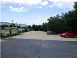
From Razdrto take the expressway to Nova Gorica or vice versa and take the Vipava exit. Follow the road onwards, towards Vipava and Gradišče. In the village of Gradišče, you will see the first mountain signs, which you follow to a large parking lot at Camp Tura above the village of Gradišče.
Path description:
From the parking lot, pass the information boards and head towards Gradiška Tura and Abram. At first, a relatively wide path leads through the forest and soon leads to a crossroads at a small clearing. Here, the path to St Nicholas branches off to the right, and we continue to the left towards Gradiška Tura.
From the crossroads, the path quickly leads to a scree slope and then turns to the right. We continue on the marked path and follow the signs for Gradiška Tura. Along the way, you will also see signs indicating the climbing routes. The trail then starts to climb a little steeper and occasionally we start to get some nice views of the Vipava valley. The path that runs along the bushes and through the low forest leads us to the next marked crossroads where the Furlan route to Gradiška Tura branches off to the left.
We continue to the right where we are directed by signs to Gradiška Tura along Otmar's path. The path then runs on a slightly steeper slope where we are also helped by some fixed safety gear. Following such a path, we then reach the scenic Oltar.
From the Altar, we continue along the steep path, which is protected in places by a steel cable or rungs, and soon we are back at the crossroads. This time, the usual easier path to Gradiška Tura branches off to the left, and we head right towards the Otmar path. After a short crossing, the path then leads us under the wall where the start of the protected climbing route is.
Before entering the climbing part of the route, equip yourself with a helmet and a self-protection kit. Climbing gloves are recommended. At the start, which is the most difficult part of the route, you will first climb steeply up a number of scrambles. The route then turns to the left and there is a very exposed traverse of the wall where the many crampons are still there to help you. After crossing the crag, the path turns right and climbs up over a short overhang (difficulty C).
Above the overhang, there is a slightly less difficult climb on scree, which leads to a ledge by a tree. Above the tree, we then climb up a still relatively steep but well-defined slope where, in addition to the rope, we are occasionally helped by a few staples or footsteps carved into the rock. The path here runs slightly to the right and then turns left upwards and leads us to flatter terrain where the protected path ends for a short time. Here, the cross path from the top of the Furlan Trail joins from the left.
Continue along the scenic trail, which quickly leads to the jeklenice again. At first, we climb along the rocks along the rocks, then we climb again along the staples, which also help us to climb over a very short overhang. The path then turns to the right and is followed by a slightly exposed traverse which leads to the next scrambles. With the help of a number of crampons, you climb up the wall. Continue again slightly to the right and the path leads to slightly less steep and more vegetated terrain. Here we then climb along a steel beam for some time on a slightly less difficult slope and, a little higher up, the protected route ends again for a short time.
Continue right along the path, which leads past the memorial plaque to the last part of the protected path.
Here we climb steeply again with the help of crampons and then climb quite steeply for some time on a wide path. In the last part, there is a climb over a short chimney and then the protected path ends.
At the end of the protected path, where an easier path joins us from the left, continue straight ahead and after about 10 minutes of climbing reach the scenic summit.
This trail is categorised as a very difficult mountaineering trail and it is compulsory to wear a self-protection kit and a helmet. In the initial part, which reaches difficulty level C, some strength in the arms is also needed in the overhang. The assured route is 450 metres long and has an elevation gain of 240 metres.

Pictures:
 1
1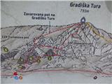 2
2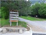 3
3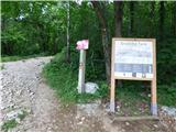 4
4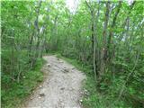 5
5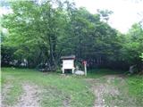 6
6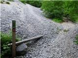 7
7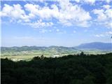 8
8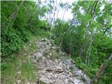 9
9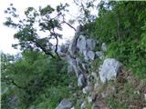 10
10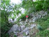 11
11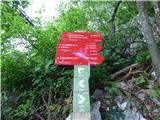 12
12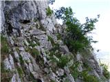 13
13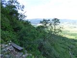 14
14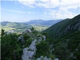 15
15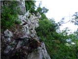 16
16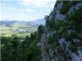 17
17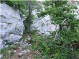 18
18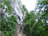 19
19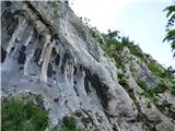 20
20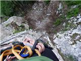 21
21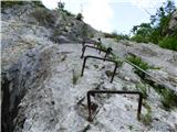 22
22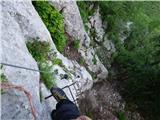 23
23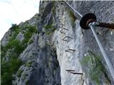 24
24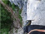 25
25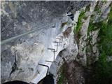 26
26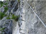 27
27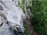 28
28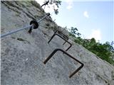 29
29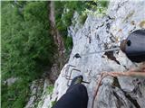 30
30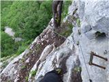 31
31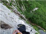 32
32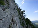 33
33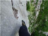 34
34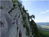 35
35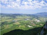 36
36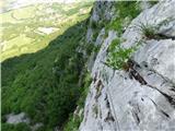 37
37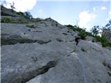 38
38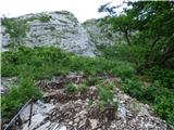 39
39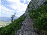 40
40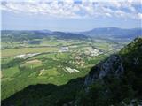 41
41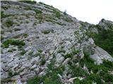 42
42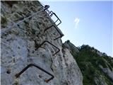 43
43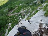 44
44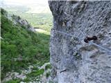 45
45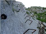 46
46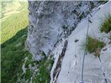 47
47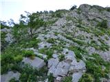 48
48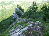 49
49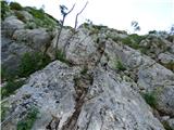 50
50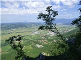 51
51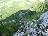 52
52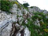 53
53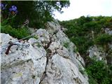 54
54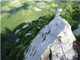 55
55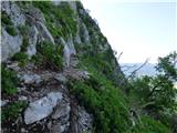 56
56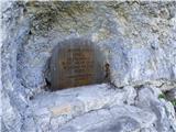 57
57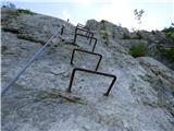 58
58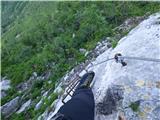 59
59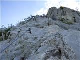 60
60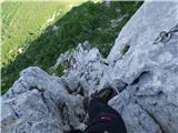 61
61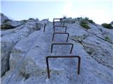 62
62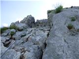 63
63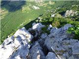 64
64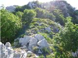 65
65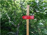 66
66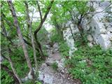 67
67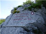 68
68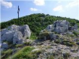 69
69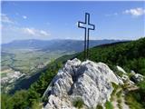 70
70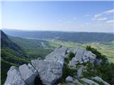 71
71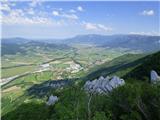 72
72
Discussion about the trail Gradišče - Gradiška Tura (Otmar route)
|
| damijan6614. 06. 2019 |
Bi lahko kdo naredil primerjavo te poti s rdečo varianto Grančišča?
|
|
|
|
| JORDAN15. 06. 2019 |
Otmarjeva preplezana danes in lahko pohvalim izvajalce.Danes je bila suha in po moji oceni tehnično malo lažja vendar daljša kot rdeča Grančišče.Prakticirajte jo najprej z Furlanovo za ogrevanje.
|
|
|
|
| VanSims25. 06. 2019 |
Aja, jaz bi pa rekel kar precej lažja.
Dosega sicer nekaj zelo kratkih C-jev. Ostalo je lažje, veliko dolgih B-jev in A/B-jev. Ni pa za podcenjevati. Bolj je mordaa primerljiva z modro (nekoliko težja).
Tistim ki napredujete po feratah po težavnosti morda: Furlanova, modra Mojstrana, Otmarjeva, potem še vmes 2-3 malo težje in nato rdeča Mojstrana.
|
|
|
|
| Jurc8925. 02. 2020 |
Ali je označena pot, da se gre najprej na Furlanovo, potem pa se spusti na začetek otmarjeve? Lp
|
|
|
|
| darinka425. 02. 2020 |
Tam je vse označeno. Tudi pot je urejena tako , da lahko zahteven prvi del obideš in greš po Furlanovi in nadaljuješ po Otmarjevi do vrha.
|
|
|
|
| Berstuk23. 10. 2020 |
Sva bila v začetku oktobra - čudovita  Nisem pa opazil (niti gledal), kje bi se dalo zaobiti prvi del Otmarjeve. Razmišljem, da bi peljal očeta in mamo, njej sicer ne bi delalo težav, oče pa več kot Hvadnika ali Aljaževe v Mojstrani še ni prehodil. Fizično je sicer odlično pripravljen za svojih 67 let, sam ga ne bi vlačil čez ta del... A je kaka puščica oz. oznaka? Hvala
|
|
|
|
| bongo23. 10. 2020 |
Odcep za obvoz (cca 2-3 minute po sestopu s Furlanove) sicer ni oznacen, ga pa ne mores zgresiti. Tam je ob poti postavljena informacijska tabla, sam obvoz pa zgleda malo zarascen, a ni, samo manj shojen je.
In pohvale PD Vipava za urejenost Gradiske ture. Srecno
|
|
|
|
| Berstuk15. 11. 2020 |
Bongo, hvala za info Bomo šli, ko nam dvignejo ukrepe 
|
|
|
|
| PUHIPUHI30. 04. 2021 19:55:11 |
Zanima me, če ima kdo izkušnje, kako hitro se ta stena po dežju posuši? Če bo danes ponoči še deževalo, ali je jutri zjutraj smiselen obisk te ferate ,ali bo preveč gladko? Hvala
|
|
|
|
| kraška sapca8. 02. 2022 11:41:23 |
Včeraj 7.2.2022 sem plezala po Gradiški s punco, ki ji je ime Daša. DAŠA, če bereš to, se mi prosim javi, da ti pošljem slike Drugače pa odgovor na zadnji komentar: včeraj sta povedala dva ki sta prespala v kampu Tura, da je zjutraj deževalo, ko sem jaz prišla okoli 11.ure, je bila skala že čisto suha. Obe poti sta v lepo vzdrževani, brez poškodb, zajle napete ko strune. Ni pa to kategorija za začetnike, po moji presoji.
|
|
|
|
| Danak26. 11. 2022 12:53:10 |
Pozdravljeni, Parkrat sem opravil Gradiško turo, pa tudi vse tri ferate v dolini Glinščice. Katera bi bila po težavnosti primerna za naslednji izziv? Hvala za odgovore
|
|
|
|
| turbo27. 11. 2022 11:29:14 |
|
|
|
|
| avrikelj27. 11. 2022 22:28:50 |
Danak, če si preplezal težjo Otmarjevo z odseki z označeno težavnostnostjo D in E (z nogami na trenje in ne ob pomoči skob in opor za noge), potemtakem ne boš imel težav na nobeni slovenski ferati.
|
|
|
|
| darinka43. 04. 2023 21:43:23 |
Smo šli dopoldne s Kamp ture. Najprej na Furlanovo. Se spustili na začetek Otmarjeve. Gneče prav nobene. V steni je bilo kar mirno. Le na vrhu nekoliko vetrovno. Dan pa prav lep- sončen.
|
|
|
|
| MinasTirith29. 04. 2023 18:28:24 |
Pozdravljeni,
zanima me ali kdo te dneve hodil po ferati Furlanova in Otmarjeva pot? Zanima me kakšne so razmere, saj nameravam izvesti pohod (po ferati) 15 ali 16 maja.
Vse informacije so dobrodošle.
V naprej se vam zahvaljujem za informacije.
|
|
|
|
| bpavsic29. 04. 2023 19:33:53 |
Ja, ravno danes smo se povzpeli po obeh. Razmere so bile super. Mi smo štartali okrog 8:00, vreme je bilo oblačno in ravno prav za plezanje. Pozneje, ko smo se vračali (naokrog preko Plazu do Gradišča, v primerjavi z direktno potjo dol, je ta "avtocesta", traja pa cca 1h), je že bilo sonce in je postalo kar vroče. Jeklenice so vse ok, napete. Gneče ni bilo, srečali smo vsega skupaj par ljudi, tudi pri kamp Tura so bili cel dan parkirni prostori še prosti. https://connect.garmin.com/modern/activity/11005455622
|
|
|
|
| MinasTirith16. 05. 2023 10:44:41 |
Bil na omenjeni ferati dne 16.5.2023. Pot je lepo vzdrževana, brez posebnosti in nevarnosti.
|
|
|
|
| balon1. 02. 2024 08:03:09 |
Pozdravljeni, zanima me kakšne so razmere za vzpon? Ali je kaj pomrznjeno, ter kakšna je pot v nadaljevanju do Abrama?
|
|
|