Gozd Martuljek - Bivak pod Špikom (along the river)
Starting point: Gozd Martuljek (750 m)
| Lat/Lon: | 46,4821°N 13,8378°E |
| |
Name of path: along the river
Time of walking: 2 h
Difficulty: easy marked way
Altitude difference: 674 m
Altitude difference po putu: 675 m
Map: Kranjska Gora 1:30.000
Recommended equipment (summer): helmet
Recommended equipment (winter): helmet, ice axe, crampons
Views: 23.102
 | 3 people like this post |
Access to the starting point:
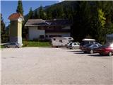
From Mojstrana drive to Kranjska Gora or vice versa, but only as far as the village of Gozd-Martuljek, where you park in the parking lot near the bridge over the Sava Dolinka river (the parking lot is located behind the bridge, or in front if you are coming from Kranjska Gora).
Path description:
From the parking lot, continue along the main road towards Kranjska Gora, but only to the point where the cycle path branches off to the left (there are also mountain signs at the start of the cycle path, which also direct you to the road). Follow the cycle path to the first crossroads, where you continue straight onto the dirt road (the cycle path turns right), which quickly leads you to the next crossroads.
Continue to the right and follow the road closed to traffic until you reach the TNP signpost. Further on, the path splits into two parts. Take the path to the left, which leads to a small bridge crossing the river. Immediately after the little bridge, turn right into the gorge of Martuljških falls. The path ahead is exposed to falling rocks, so it is best to wear helmets. The path ahead climbs up along the river, initially gently, and then begins to climb steeply with the help of steps. The path then crosses a large bridge over the river and on the other side climbs up steps below the cliff. Just a few steps further on, the path leads to another bridge with a beautiful view of the Lower Martuljkov waterfall.
After the bridge, the path turns left and climbs under the steep slopes near the waterfall. Continue to the right, following the wet ground almost horizontally. The path ahead climbs steeper and after a short ascent leads to cart track, where you continue left (here you join the path that bypasses the gorge). After a few steps, the path leads to a crossroads where the path to the bivouac under Špik (straight ahead Zgornji Martuljkov slap) branches off to the right. Take this path, which initially climbs gently along cart track. As the path approaches the torrent, you will come across an orientation lop. The path goes left to the torrent and then disappears, we continue straight on past a small boulder on which there is a marker. After this, our path also approaches the torrent but does not cross it yet. It continues up the right side and crosses it a little later. The crossing is not difficult, but the climb out of the torrent back to the path is a bit more difficult. This part is only three metres long, so it does not cause us any problems. The path continues gently climbing through the forest to the next torrent at which there is a boulder with a large marker. The way forward begins to climb steeply up a woded slope. In the middle of this climb we come across a small spring and a pleasant bench a little further on. Further on, the forest becomes more and more sparse and the path leads us to the unspoilt slopes below Špik, where we encounter torrential layers of rocks. The path turns slightly right here and goes into the forest again. After a few minutes of walking up a moderate incline away from the torrential deposits, we reach the bivouac below Špik.

Pictures:
 1
1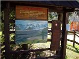 2
2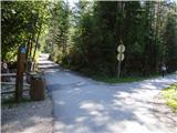 3
3 4
4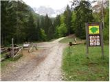 5
5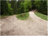 6
6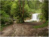 7
7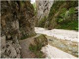 8
8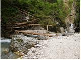 9
9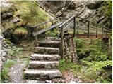 10
10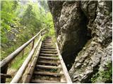 11
11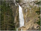 12
12 13
13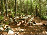 14
14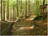 15
15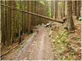 16
16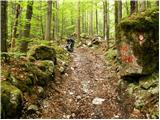 17
17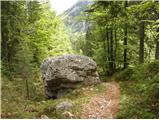 18
18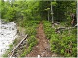 19
19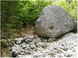 20
20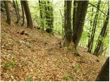 21
21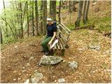 22
22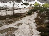 23
23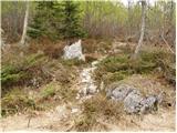 24
24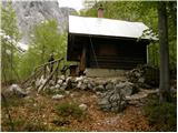 25
25
Discussion about the trail Gozd Martuljek - Bivak pod Špikom (along the river)
|
| klinchy14. 11. 2012 |
To ni vredno da se imenuje Bivak.....
|
|
|
|
| plavžar14. 11. 2012 |
Prosim, pojasni zakaj ni vredno da se imenuje Bivak!
|
|
|
|
| potočan14. 11. 2012 |
To je eden najboljših bivakov v Julijcih.
|
|
|
|
| klinchy4. 03. 2013 |
Ne vem zakaj spodnji del bivaka ni odprt?
Zgoraj je pa zelo načisto in vse smrdi...
Obiskal sem kar nekaj bivakov in ta je v najslabšem stanju do sedaj.
|
|
|
|
| Jonny_20. 07. 2015 |
Pot je zaradi obnove uradno zaprta do preklica.
|
|
|
|
| MountaineerX15. 11. 2017 |
Danes - Spodnji slap lepo prehoden, snega okoli 5 cm. Spolzko zaradi listja. Več snega je tam okoli 1000 n.m.v.. Od 30cm pa celo do 70cm. Poti nisva dokončala zaradi psa, saj je ta plaval po snegu.  Gaz sva naredila do zgornje klopce. Cepinček in osnovne dereze zadostujejo... Srečno in LP 
|
|
|
|
| michael6613. 09. 2018 |
Hmmm,res ne vem,kje pride do razlike med višinama na tej poti 
|
|
|
|
| Tadej13. 09. 2018 |
Hvala za opozorilo. Sem popravil.
|
|
|