End of road on Pokljuka - Vernar
Starting point: End of road on Pokljuka (1340 m)
| Lat/Lon: | 46,3386°N 13,9045°E |
| |
Time of walking: 4 h 15 min
Difficulty: very difficult pathless terrain
Altitude difference: 885 m
Altitude difference po putu: 1000 m
Map: Triglav 1:25.000
Recommended equipment (summer): helmet
Recommended equipment (winter): helmet, ice axe, crampons
Views: 24.044
 | 6 people like this post |
Access to the starting point:
a) Leave the Gorenjska motorway at the exit for Lesce, then follow the signs for Bled and Pokljuka. Continue through Gorje and past the ski resort Zatrnik to Rudni Polje on Pokljuka, where there is a large pay parking lot and a military barracks and shooting range nearby. From here, continue straight along the macadam road, which leads us a little further to a crossroads, where we continue to the right (Uskovnica on the left). Follow this road to the former parking lot Za Ribnico, which is at the end of the road (there are mountain signs for mountain pasture Konjščico).
After the new parking at the end of the road is forbidden, so we park already at Rudne polje, which lengthens the route by about 40 minutes, but it is more convenient to choose the marked trail, which starts already at Rudne polje.
b) From Železniki or Podbrdo, take the road to Bohinjska Bistrica and then continue in the direction of Bled. Shortly after the Petrol station, which is located just after Bohinjska Bistrica, turn left in the direction of Pokljuka and Jereka. The road climbs steeply at first, then gradually flattens out behind Koriti, leading to a junction by the bus station, where you continue right in the direction of Pokljuka, Koprivnik and Jereka (straight ahead Srednja vas). Just after the crossroads we arrive at Jereka, and from the crossroads in front of the church we continue straight on towards Pokljuka (left Podjelje). After Jereka the road starts to climb steeply again, and higher up it levels off and continues along the Mrzle potok. When you join the road from Bled, go left and drive to Rudno Polje, where there is a large pay parking lot, and also a military barracks and a shooting range nearby. From here, continue straight along the macadam road, which leads us a little further to a crossroads, where we continue to the right (Uskovnica on the left). Follow this road to the former parking lot Za Ribnico, which is at the end of the road (there are mountain signs for mountain pasture Konjščico).
After the new parking at the end of the road is forbidden, so we park already at Rudne polje, which lengthens the route by about 40 minutes, but it is more convenient to choose the marked trail, which starts already at Rudne polje.
Path description:
From the former parking lot at the end of the road, follow the wide and initially ascending cart track towards mountain pasture of Konjščice. The cart track, which goes immediately into the dense forest, is quickly laid and after a few minutes of easy walking turns into a footpath which continues along the left bank of the Ribnica stream. When the path is quite close to the stream, it turns slightly to the right and climbs steeply. Higher up, the path lays down and leads out of the forest to the lower edge of the vast Konjščice River. Here the path turns slightly to the left, crosses a small stream and, after a few further steps, leads us to the cheese cottage at mountain pasture Konjščica.
From the cheese cottage, continue along a pleasant path which, after a few minutes of gentle ascent, leads to the upper edge of mountain pasture. Here the path goes into lane of dwarf pines and scrub and gradually starts to climb more steeply. In the upper part of the ascent towards Jezerce, the path from Rudno Polje joins us from the right, and we continue straight on the moderately steep path, which leads us within a few minutes of further walking to Jezerce, where the path is laid and turns to the left.
An easy walk follows to a signpost marking the central area of the TNP, and then the path starts to climb moderately along the torrent (initially a small spring). The path goes higher up to the right side of the torrent (as seen from the route of ascent) and then climbs crosswise to Studorski Prevala.
From the prevala, from where a beautiful view of the Bohinj side opens up, continue straight ahead (left Ablanca, right Veliki Draški vrh and sharp right Srenjski preval) along the path, which begins to descend and after a few steps turns to the right. There is a short descent, and then the path continues to cross, first the slopes below Veliki Draški vrh and later Tosc. When we reach the unmarked southern slopes of Tosc, we will come to a small crossroads where the unmarked path to Tosc branches off to the right (the branch is marked). Just a few steps further on, the path from Uskovnica almost imperceptibly joins us from the left.
Continue straight ahead along the scenic route, which begins to turn increasingly to the right, passing onto the increasingly steep slopes of Tosc. Further on, you reach an artificially carved rock ledge, over which a wide path leads, exposed to falling rocks (beware - an active boulder!). Cross the ledge in a gentle descent, then turn left and climb briefly on a slightly narrower path. Further on, the path flattens out and switches to less steep slopes. Just a little further on, we come to a marked crossroads where the path from the Voje valley joins us from the left. Continue straight on towards Vodnikov dom (slightly left Velo polje) along the gently sloping path, which soon opens up a fine view of Triglav. The way ahead returns under the slopes of Tosc and, crossing the scree, leads us in a few minutes to Vodnikov dom in Velo Polje. At the house, continue right in the direction of Krma (straight ahead Triglav) along a steep path that first climbs by the botanical garden and then ascends over relatively steep, mostly grassy slopes. Higher up, the path becomes a small, undistinguished valley, which, after a few minutes of steep climbing, leads to the Bohinjska vratace (Bohinj Necks).
From Bohinjska vratca continue left on an unmarked path leading up a grassy slope. The grassy slope becomes steeper and steeper and is very dangerous for slipping, especially in wet conditions. Follow the steep track slightly to the left of the ridge up to a grassy headland at 2183m.
From the summit, continue along the ridge, initially descending steeply for a few metres on a rocky slope. Continue along the ridge, which becomes quite narrow and exposed. Walk mainly on the left side of the ridge, with some cairns indicating the direction. There are a few more very short climbing spots (level I-II) and we are already at the top of Vernar.

Pictures:
 1
1 2
2 3
3 4
4 5
5 6
6 7
7 8
8 9
9 10
10 11
11 12
12 13
13 14
14 15
15 16
16 17
17 18
18 19
19 20
20 21
21 22
22 23
23 24
24 25
25 26
26 27
27 28
28 29
29 30
30 31
31 32
32 33
33 34
34 35
35 36
36 37
37 38
38 39
39 40
40 41
41 42
42 43
43 44
44 45
45 46
46 47
47 48
48 49
49 50
50 51
51 52
52 53
53 54
54 55
55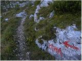 56
56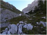 57
57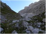 58
58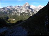 59
59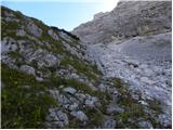 60
60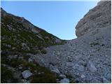 61
61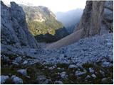 62
62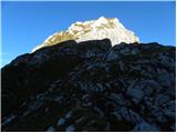 63
63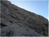 64
64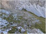 65
65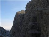 66
66 67
67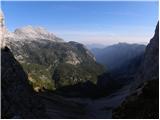 68
68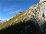 69
69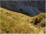 70
70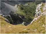 71
71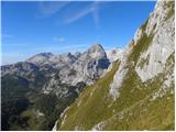 72
72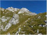 73
73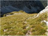 74
74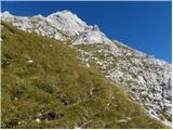 75
75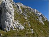 76
76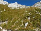 77
77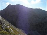 78
78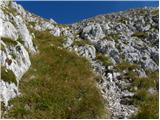 79
79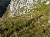 80
80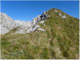 81
81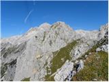 82
82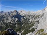 83
83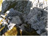 84
84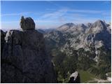 85
85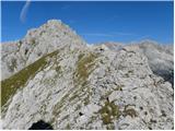 86
86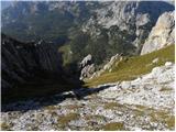 87
87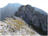 88
88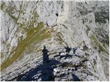 89
89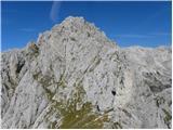 90
90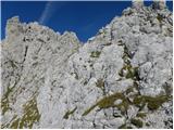 91
91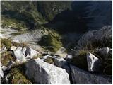 92
92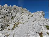 93
93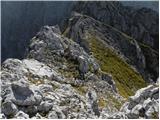 94
94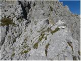 95
95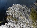 96
96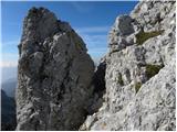 97
97 98
98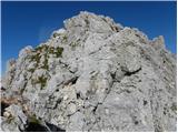 99
99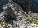 100
100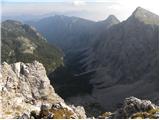 101
101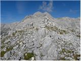 102
102
Discussion about the trail End of road on Pokljuka - Vernar
|
| Jože.15. 09. 2010 |
Včeraj bil na vrhu. Nikjer žive duše, razen par svizcev. Razgled enkraten.
|
|
|
|
| netline10. 08. 2014 |
Vzpon na Vernar je lepo doživetje. Ko ga gledaš od spodaj s poti proti Vodnikovemu domu, se zdi strm in neosvojljiv.
Z Bohinjskih vratc zgleda že bolj človeški, ko pa se po njem že vzpenjaš, je še malo lažje. Plezarije je malo in še ta je lahka. Skala je precej dobra z zelo redkimi krušljivimi mesti. Po 10h poleti je rosa že več ali manj posušena in nevarnost za kak zdrs je manjša. Glede na določene raztreščene skale je najbrž na grebenu velika nevarnost strele.
Meni osebno se je zdel vzpon na Vernar veliko bolj (orientacisjko in tehnično) enostaven kot vzpon na Tosc po lovski stezi iz Bohinjskih vratc.
|
|
|
|
| ločanka10. 08. 2014 |
Problem ni orieantacijski, ampak v izpostavljenosti v povezavi med predvrhom in glavnem vrhu. Povsem se strinjam z opisom poti, še posebno je na mestu zadnji odstavek.
Pred leti smo namreč tu hodili z otroci in še danes me zmrazi ob misli, koliko smo v resnici tvegali.
|
|
|
|
| katja874. 11. 2014 |
V nedeljo smo naredili čudovito krožno turo: Konec ceste na Pokljuki - Jezerce - Studorski preval - Vodnikov dom - Bohinjska vratca - Vernar - Bohinjska vratca - Tosc (po brezpotju čez SZ steno) - Studorski preval - Jezerce - Pokljuka. Za celotno turo smo rabili 11 ur, z daljšimi postanki na vrhovih. Celotna pot je bila kopna, razen dela od Jezerc na Studorski preval ter posameznih prečnic v SZ steni Tosca. Pot na Vernar je izredno lepa, poplezavanje po grebenu pa prav adrenalinsko. Vrh ponuja prekrasne razglede, predvsem na sosednji Triglav  Več slik in opis ture je objavljen na spletni strani Planinskega društva Matica Murska Sobota: http://www.pdmaticams-drustvo.si/
|
|
|
|
| MPS7. 11. 2020 |
Prejšni teden sem šel na Vernar iz Pokljuke. Pot je bila brez posebnosti, snega na zahtevnejših predelih ni bilo več. Za lažjo predstavo o poti sem posnel in sestavil kratek filmček, ki si ga lahko ogledate na povezavi: Vernar, Julijske Alpe, oktober 2020 Upam, da bo komu v pomoč.  Varen korak in srečno, Mirko
|
|
|
|
| velkavrh8. 11. 2020 |
MPS čudovito posneto! Žal moram pripomniti, da se na Verner ni varno povzpeti brez čelade. Gor sem bil trikrat. Pa še krasna muzika je zraven-ne poznam izvajalca .
|
|
|
|
| MPS9. 11. 2020 |
Hvala, velkavrh. Se strinjam glede čelade. Običajno jo imam na glavi, tisti dan pa sem jo pozabil. Pesem v filmčku je od Eddija Wedderja, pevca skupine Pearl Jam.  Srečno.
|
|
|
|
| bo_zl10. 07. 2024 17:42:35 |
Pot priporočam za vse ki imajo radi mir. Seveda od Vodnikovega doma naprje. Zadnjih 15 minut pa je kot nalašč za tiste, ki imate radi ozke, izpostavljene,nezavarovane grebenčke. Tudi nekaj možicev pokaže pravo smer, sem vse ki sem jih videl še povečal za kamen ali dva.
|
|
|
|
| Darxta11. 08. 2025 10:27:51 |
Včeraj smo se s PD Medvode povzpeli na Vernar s štartom iz Rudnega polja. Pot od Bohinjskih vratc do predvrha je strma, a lahko sledljiva. Grebenski skalnati del od predvrha do Vernarja je precej adrenalinski, nam pa je bilo lažje ker je vodička pokazala najboljšo pot po skalah, ki niso bile preveč krušljive.
Čelada je zelo priporočljiva, v primeru da vas gre več pa že kar obvezna zaradi odsekov, kjer je nekdo nad/pod vami in se lahko sproži kakšen kamen.
|
|
|