Dolina Todorov do - Prutaš
Starting point: Dolina Todorov do (1820 m)
| Lat/Lon: | 43,12772°N 18,98763°E |
| |
Time of walking: 1 h 30 min
Difficulty: partly demanding marked way
Altitude difference: 573 m
Altitude difference po putu: 575 m
Map: Durmitor 1 : 22000
Recommended equipment (summer):
Recommended equipment (winter):
Views: 3.230
 | 3 people like this post |
Access to the starting point:
Some 4 km south of Žabljak we find a crossing from the Žabljak-Nikšić road to the Žabljak-Sedlo-Trsa-Plužine road (currently not marked! ) and follow the sloping, high-mountain, asphalted road over the Sedlo saddle to the Todorov valley, located directly below the western slope of Prutaš (from Žabljak approx. 24 km, from Sedlo approx. 10 km). Park in the small parking lot at the turnoff of the dirt road leading to mountain pasture (from Žabljak approx. 24 km, from Sedlo approx. 10 km).
Path description:
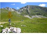
At the starting point, Prutaš stands before us in all its glory. The path first leads us across mountain pasture past a watering hole and a trough (a few minutes). Then we climb relatively steadily and steeply, all along the western slope or in the direction of the saddle already visible from below to the left of the summit (between Prutaš and Gruda). We climb partly on grassland, partly on scree. Just before the saddle (about 1:00 to reach here) turn right and follow the rocky north ridge steeply upwards. Higher up, traverse left to a short steep ridge, which leads out (slightly exposed) onto a more exposed grassy ridge. After a few minutes on the ridge, stand on the headland, where you take a well-marked fork to the right or straight ahead (to the left is the path towards Šrkčki jezero). In a few minutes you reach a spacious grassy summit.
Suggestion for a short extension: It is worth descending from the top for 15 minutes or 50 metres along the path towards Škrčki jezera, as the lower parts of the ridge offer a beautiful view of the lakes.

Pictures:
 1
1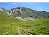 2
2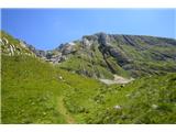 3
3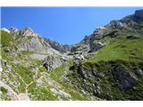 4
4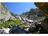 5
5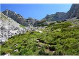 6
6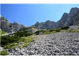 7
7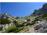 8
8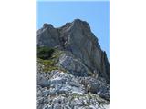 9
9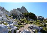 10
10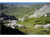 11
11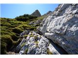 12
12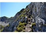 13
13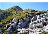 14
14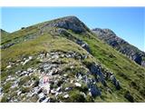 15
15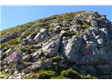 16
16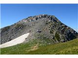 17
17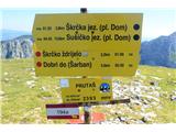 18
18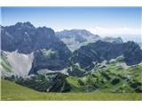 19
19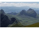 20
20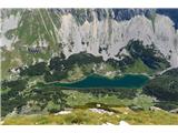 21
21
Discussion about the trail Dolina Todorov do - Prutaš
|
| nejka4029. 06. 2019 |
Cudovita gora s prekrasnimi razgledi,kratka a sladka,le pri zadnjem delu- slika 14 je mal izpostavljeno,a je dosti oprimkov,skala čvrsta.  .
|
|
|