Starting point: Dolina Krma (944 m)
| Lat/Lon: | 46,3851°N 13,9071°E |
| |
Time of walking: 7 h 15 min
Difficulty: difficult marked way
Altitude difference: 1449 m
Altitude difference po putu: 1780 m
Map: TNP 1:50.000
Recommended equipment (summer): helmet, self belay set
Recommended equipment (winter): helmet, self belay set, ice axe, crampons
Views: 3.380
 | 3 people like this post |
Access to the starting point:
Leave the Gorenjska motorway at the Hrušica exit and follow the road towards Kranjska Gora. Just before the village of Dovje, the road branches off to the left and leads to Mojstrana (Vrata, Kot and Krma). Follow the road in the direction of the village of Radovna and the valleys of Krma and Kot. The relatively steep road then takes us past the TNP signboard, after which the road soon lays down and leads us to a crossroads where the macadam road to the valley of Kot branches off to the right. Continue straight ahead on the road, which begins to descend. In the middle of the descent, the road to the Krma valley branches off to the right (straight ahead Radovna). A little further on, you come to the next crossroads, where you continue to the right in the direction of Krma. The macadam road then leads to Kovinarska hut, and we follow it further. Occasionally, a slightly worse road then leads us to the parking area in front of the barrier.
Path description:
From the parking lot, pass the ramp and continue along the forest road, which is closed to public traffic. The minor road continues for a while on extensive gravel, then turns slightly to the right and enters the forest, where it turns into a rocky cart track. The path climbs gently through the forest for some time, and then, after crossing a slightly larger torrent, it begins to climb steeply through the dense forest. Higher up, the path leaves the forest into lane of dwarf pines, mixed with scrub, and climbs over the above-mentioned slope on a scree slope. At an altitude of about 1400 m the path is laid and after a further walk of some 10 steps leads to a beautiful grassy plain called Vrtača.
On the other side of the plain, the wide path starts to climb again and after about 20 minutes of further walking leads us to Malo polje, where it turns to the right and leads us to a less conspicuous crossroads. Continue along the well-traced path (left Vodnikov dom via Bohinjska vratca), which climbs gently for a while and then leads to a water trough. Next, the path splits into two parts, and we continue straight on the marked path, which leads us over initially grassy, then slightly vegetated slopes to the shepherd's hut at mountain pasture Zgornja Krma.
Just a few minutes above mountain pasture, the path leads to a crossroads at a small well. Continue right in the direction of Kredarica and Stanič's home (Planika on the left). After a few minutes of further walking, the gently sloping path leads us to the next crossroads, where we continue straight in the direction of Stanič's home (left Kredarica - the path over Kalvarija). Continue almost horizontally along the path, which crosses a belt of sparse larch forest, then passes out of the forest onto the viewing slopes and turns slightly to the left. Continue climbing moderately up the slopes between Pungrt and Apnenica. Higher up, the path enters the rocky world of the western slopes of Rjavina and turns sharp left below Dovška vratca. Continue gently to moderately ascending towards the slopes of Rž (a mountain with a natural window, which is clearly visible from the path), where the path from Konjski sedlo joins from the left. Continue to the right and the path quickly leads to the next crossroads, where the path to Rjavina - the ridge path - branches off to the right. Continue straight in the direction of Stanič's home, following the path which begins to descend and leads us within a few minutes of descent to the Valentina Stanič Mountain Home. From home, continue in the direction of Begunjski vrh, Visoka Vrbanova špica and Cmira. After a few minutes of walking, the rather gently sloping path leads us to Begunjski Preval, where the path to Vrbanove špice branches off to the right, and we continue straight ahead along the path, which soon splits into two parts.
Continue straight ahead (left Begunjski vrh) on the path which crosses the north-eastern slopes of Begunjski vrh (possible snowfields in early summer) and leads to a small saddle behind the summit. Here we have a fine view of the Vrata valley and the surrounding mountains.
The path then turns right and crosses a well-protected smooth rock slab. The path then climbs steeply and leads to a very scenic ridge, which you follow north-eastwards. The pleasantly scenic route is then stopped by a steep rock step, which is followed vertically downwards (10 m) on a perfectly protected path. The path, which is then slightly easier, descends for a while and then starts to climb towards Rjavčev galvas. After a few minutes' ascent, the path starts to descend on a steep grassy slope (danger of slipping). The path continues on a moderate ascent to a narrow and exposed ridge, from which it descends to a notch below the main peak Cmira. On the other side, the trail turns slightly to the left and starts to climb steeply up the top slope of the mountain. After about 15 minutes of steep climbing, you reach the top of Cmira, which offers a very nice view.
Krma - Zgornja Krma 2:30, Zgornja Krma - Staničev dom 2:45, Staničev dom - Cmir 2:00.

Pictures:
 1
1 2
2 3
3 4
4 5
5 6
6 7
7 8
8 9
9 10
10 11
11 12
12 13
13 14
14 15
15 16
16 17
17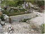 18
18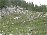 19
19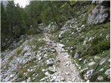 20
20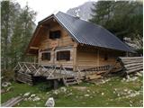 21
21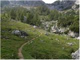 22
22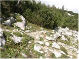 23
23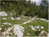 24
24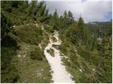 25
25 26
26 27
27 28
28 29
29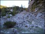 30
30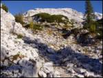 31
31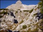 32
32 33
33 34
34 35
35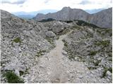 36
36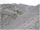 37
37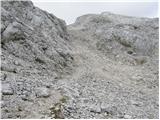 38
38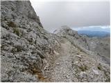 39
39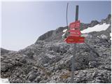 40
40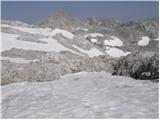 41
41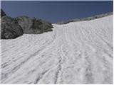 42
42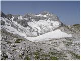 43
43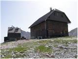 44
44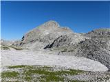 45
45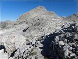 46
46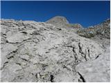 47
47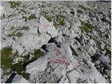 48
48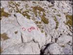 49
49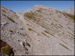 50
50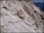 51
51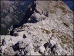 52
52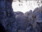 53
53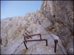 54
54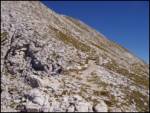 55
55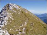 56
56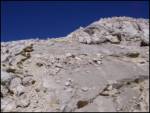 57
57 58
58
Discussion about the trail Dolina Krma - Cmir
|
| trdi22. 08. 2018 |
Čudi me, da je ta pot iz Krme označena kot zelo zahtevna, poti iz Kota in čez Prag pa le kot zahtevni?
|
|
|
|
| Tadej22. 08. 2018 |
Hvala za opozorilo. Prišlo je do napake. Sem popravil. Lp, Tadej
|
|
|