NC Planica - Slemenova špica (via Grlo)
Starting point: NC Planica (931 m)
| Latitude/Longitude: | 46,476°N 13,7241°E |
| |
Route name: via Grlo
Walking time: 2 h 55 min
Difficulty: difficult marked way
Elevation gain: 980 m
Elevation difference along the route: 990 m
Map: Kranjska Gora 1:30.000
Recommended equipment (summer): helmet
Recommended equipment (winter): helmet, ice axe, crampons
Views: 58.141
 | 3 people like this post |
Access to starting point:
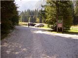
a) First we drive to Kranjska Gora, then continue driving towards Rateče. When we reach the roundabout near Rateče, we take the exit in the direction of Planica. There follows some more ascent and we arrive at the large parking lot next to the Nordic Centre Planica, where we park in the paid parking lot. The price for passenger cars is 2.5 euros / day (March 2019).
b) Via the Rateče border crossing we drive into Slovenia, then soon turn right towards Planica. There follows some more ascent and we arrive at the large parking lot next to the Nordic Centre Planica, where we park in the paid parking lot. The price for passenger cars is 2.5 euros / day (March 2019).
Route description:
From Planica we continue along the macadam road towards Dom v Tamarju, before the road enters the forest it splits into two parts. We continue along the road that branches slightly to the right in the direction of the footpath towards Tamar (slightly left is the drivable road, which is closed to public traffic).
The path ahead leads us along the road, which passes the last parking lot of NC Planica, enters the forest and which in winter is converted into a cross-country ski trail. This is followed by an ascent along a gentle road that mostly runs through the forest, when the path leaves the forest, there are information boards along the path about what can be seen. Higher up the forest thins out several times or we leave it for a while, so that beautiful views open up of the mountains rising above Planica and Tamar. When we get quite close to Dom v Tamarju a wonderful view of Jalovec opens up and the path splits.
We continue slightly left (slightly right is the source of Nadiža) and a few minutes further we join the drivable road, along which we continue left, back towards Planica (right to Dom v Tamarju, two minutes).
We do not walk along the road for long and soon arrive at a junction, where we turn right in the direction of Vršič and Slemenova špica through Grlo (you can also get here by road).
We head onto the mentioned path, which after a few steps takes us from the forest onto vast gravel areas. The path ahead ascends gently slightly to the left to the outlet of the mighty gorge that we see in front of us. The path then leads us right into the gorge along which the path continues. Further we ascend up the gorge looking for passages which change after every heavier rainfall. The path through the gorge is marked but many markings are upside down and where the marking is the passage is often almost impossible. The entire approximately 45-minute passage through the gorge is also exposed to falling rocks. The ascent through the gorge is difficult but nowhere exposed. We exit the gorge at the Grlo saddle, where a barely noticeable unmarked path from the Mala Pišnica valley joins us.
We continue right in the direction of Slemenova špica and Vršič. The path ahead crosses a shorter stretch of forest and a bit higher leads us to scree slopes which the path crosses in a slight ascent to steep slopes. Here the path steeply ascends, and we are assisted by a few pitons and a steel cable. Further we ascend along a moderately overgrown slope quite steeply upwards to the place where we join the path from Vršič.
Here we continue right along the path, which only occasionally ascends more and soon brings us to the small lakes on Sleme from which there is a nice view of Jalovec. We continue slightly to the right past the summit register box to the top of Slemenova špica, which we reach in a few minutes of further walking.
Planica - turnoff for Grlo 0:45, turnoff for Grlo - Grlo 0:55, Grlo - Čez Sleme 0:55, Čez Sleme - Slatnica 0:10, Slatnica - Slemenova špica 0:10.

Along the route: Dom v Tamarju (1108m), Odcep za Grlo (1090m), Grlo (1451m), Odcep v Pišnico (1489m), Čez Sleme (1773m), Slatnica (1814m), Jezerca na Slemenu (1855m)
Photos:
 1
1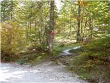 2
2 3
3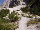 4
4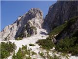 5
5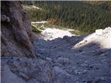 6
6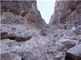 7
7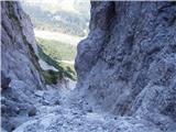 8
8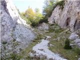 9
9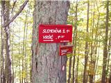 10
10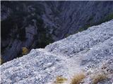 11
11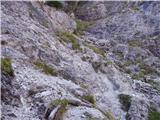 12
12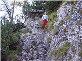 13
13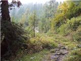 14
14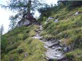 15
15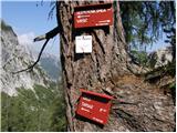 16
16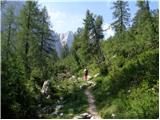 17
17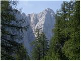 18
18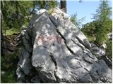 19
19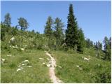 20
20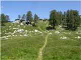 21
21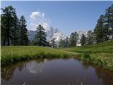 22
22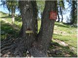 23
23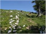 24
24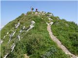 25
25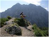 26
26
Discussion about the trip NC Planica - Slemenova špica (via Grlo)
|
| o_O17. 09. 2010 |
Above Grlo very interesting and nice path, but Grlo is f#%k!...
|
|
|
|
| merkur23. 06. 2011 |
To Grlo nothing! I didn't go further (on 20.6. came through Mala Pišnica and descended to Tamar), but it's practically almost impossible for snow to hinder you anywhere higher.
|
|
|
|
| VanSims2. 10. 2011 |
Actually, in Grlo the markings quite well indicate the direction of travel. Only here and there something is upside down. We can also help ourselves with the footprints of predecessors.
|
|
|
|
| Lunatic9. 11. 2011 |
Question, does anyone know what the conditions are like, also for return past Črne vode? Given that there's not much sun in between... How suitable are both paths for a dog companion
Best regards.
|
|
|
|
| VanSims9. 11. 2011 |
Through Grlo in my opinion the path is not suitable for a dog. From Grlo onwards to Špica it's a nice path though. An alternative might be access from Pišnica (I don't know what that path is like) but that path is still closed.
Through Črne vode the path is basically suitable, but right behind the waterfall (or right before it if returning) there's a somewhat more awkward slippery section, where there could be some trouble with a dog (especially downhill). Further up the path is then nice and suitable for a dog.
|
|
|
|
| Lunatic9. 11. 2011 |
Thanks for the info...
|
|
|
|
| U&Q9. 11. 2011 |
I went in the summer across the Black Waters with a larger female dog and I have to admit that I myself had more trouble crossing the section described by VanSims than she did. However, every dog has its own story...
|
|
|
|
| ajda9. 11. 2011 |
Lunatic, I don't know how it is currently on these two paths. To your last question, I can answer from my own experience. I walked this path with my dog, without problems. We went up through Grlo and back via Black Waters. It is true that the dog and its human must be a well-coordinated team if they go to the mountains together. Then the days are always too short, so much happens. Good luck on your paths.
|
|
|
|
| Lunatic9. 11. 2011 |
Thanks everyone for the info , I'll go check it out alone first, because it's not very clear from the pictures, in principle my Luna doesn't panic about crevices or heights either, she's not afraid of heights, fitness is not a problem...
But anyway, I'll check the trail alone first, and then in spring we'll do it together
|
|
|
|
| Laščan10. 11. 2011 |
On Sunday we plan to go to Slemenova špica, up through Grlo, back past Črnih vod. Please for information on path conditions (snow, ...). Thanks in advance and nice views to all!
|
|
|
|
| Laščan10. 11. 2011 |
Forgot to ask one more thing. How far into Tamar can I drive? To the mountain hut or is the road to Tamar closed as described above?
|
|
|
|
| JusAvgustin10. 11. 2011 |
road is closed, only allowed for supplier. those few kms you'll manage! park in Planica...
|
|
|
|
| Laščan10. 11. 2011 |
Thanks for the quick reply - a few km really no problem. Still curious about path conditions (snow)? Thanks again!
|
|
|
|
| Lunatic10. 11. 2011 |
Laščan, I spoke with the caretaker in Tamar, through Grlo it's snow-free, through Črne vode a few patches of snow, but there shouldn't be a problem (no need to put on crampons), Luna (dog) will wait at home, we'll see each other somewhere Start around half past six, seven from Planica, because I need to be back in LJ soon for errands
Potepuh nice pictures, if there's ever a long weekend I wouldn't mind joining you on a hike 
Best regards.
|
|
|
|
| Lunatic10. 11. 2011 |
One more thing, for half an hour of walking it's really not worth giving 200€ to the rangers and destroying roads, making noise and dust... in the morning with fast walking you just warm up... In spring, summer, autumn the rangers are daily in Tamar 
|
|
|
|
| skalar5011. 11. 2011 |
Yesterday loop Tamar - Grlo - Sleme - Črne vode - Tamar.
The path is basically without problems.
|
|
|
|
| Laščan11. 11. 2011 |
Lunatic and skalar50, thanks for the information!
|
|
|
|
| Lunatic14. 11. 2011 |
Nice trail, practically newly marked, from the chamois in the wall to the gully occasionally a stone flies by, so helmet not superfluous The lakes are already in eternal shade, but on Špica the sun still shines On return via Črne vode, some rock is secured in place and a bit more caution doesn't hurt
|
|
|
|
| ajda14. 11. 2011 |
Hello Lunatic, how did you rate the trail, could your little dog handle this trail?
|
|
|
|
| Lunatic14. 11. 2011 |
For a dog it's nice from Vršič Our Luna (Dalmatian) would probably manage up and down anyway, but it's a bit risky through the gully for a sprain, broken dog paw, jumps from rocks to uneven terrain, the trail is quite rugged, gaps between rocks , Further from the gully even that wire rope wouldn't be a problem neither up nor down... via Črne vode a bit better story, there probably no problem at all for those with shorter legs. But definitely more suitable for people, with the chamois alpine climbing in the walls above the gully you just stand speechless Just watch out for rocks from under their hooves I recommend 
|
|
|
|
| Laščan14. 11. 2011 |
Yesterday with my wife up and down past Črne vode.
Lunatic, I think we met on the bilberry patches under the Slatnica saddle. And precisely your info about stones flying through Grlo deterred us from the circular route.
|
|
|
|
| jaksa15. 11. 2011 |
I walked this trail on Saturday, up through Grlo, down through Črne vode, pure enjoyment
|
|
|
|
| Lunatic15. 11. 2011 |
We met, said hello, and continued enjoying Nice trail...
|
|
|
|
| Grega9227. 12. 2012 |
Hi
has anyone been on this path in the last few days or past Črnih vod?
what's the condition of the path?
|
|
|
|
| _d_19. 06. 2014 |
Repeating Grega's question, I'm interested in the condition of the path (up through Grlo, back past Črnih vod)?
|
|
|
|
| katty6. 08. 2015 |
Hey.
Is there any special feature on this path?
Thanks for info
|
|
|
|
| Grenaleva26. 10. 2015 |
The path was without issues yesterday, through Grlo it goes nicely slowly, not particularly crumbly, the path is well marked with markers or cairns. From the junction towards the summit, a little snow, which is well trodden. No chamois encountered, only one mountaineer. I definitely recommend going up this way for those who don't like crowds. From Planica with stops to the summit 2.45 hours.
|
|
|
|
| ločanka28. 06. 2018 |
Exciting ascent on this path, a bit different from usual paths. Start of the ascent on the left side of the gully, later more in the middle, where you can see easier passages. On the path also a view to the left to the hunting lodge in Mali Pišnica.
Don't count on encounters and greetings along the path (at least until the junction with the Vršič path).
|
|
|
|
| jarekpe(PL)15. 09. 2021 14:59:50 |
The Tamar-Grlo path is damaged and closed.
|
|
|
|
| Barpka130. 09. 2021 22:28:17 |
Jarekpe(PL), why are you spreading falsehoods? Just because you can't handle such a path? The Tamar-Grlo path is certainly not a Tivoli promenade, but a real mountaineering trail. Let's hope that PZS soon recognizes the status it deserves - difficult trail.
|
|
|
To post a comment you must log in:
If you do not yet have a username, you must first
register.