Jesenice (Ukova) - Jelenkamen (via Kalvarija)
Starting point: Jesenice (Ukova) (600 m)
| Latitude/Longitude: | 46,4362°N 14,0648°E |
| |
Route name: via Kalvarija
Walking time: 1 h 20 min
Difficulty: partly demanding marked way
Elevation gain: 496 m
Elevation difference along the route: 496 m
Map: Karavanke - osrednji del 1:50.000
Recommended equipment (summer):
Recommended equipment (winter): ice axe, crampons
Views: 19.254
 | 3 people like this post |
Access to starting point:
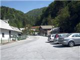
From the highway Ljubljana - Jesenice, take the exit Lipce, where we drive right towards Jesenice. In the settlement Javornik at the intersection with traffic lights we turn left towards the center of the town. At the second traffic-light intersection (at the gymnasium) we drive right back towards Tomšičeva cesta past the primary school on the left. Behind the school we drive past the pedestrian crossing and immediately turn into the first (narrower) street on the left. When we ascend it for some 10 meters, on the right we see the marked parking lot. Here is our starting point.
Route description:
From the parking lot, we continue on the road uphill, whereupon after some 10 meters on the left we notice the Ukova swimming pool, and on the right the road which branches off uphill towards the north into the forest.
We step onto the latter and follow it for a short time, i.e. to the right turn before which on the same side there is a fenced water intake. On the other - left side we step onto the path which cuts the double bend of the road we left. Here we encounter the first blazes. Quite quickly we cross the road again, and step onto the path which begins to ascend towards the north. When it starts turning left, it joins the cart track alongside which we notice a signpost. Here we turn right onto the cart track, which quickly brings us to the first small bridge (Ukova stream), over which we immediately reach the second one too. Behind it, the path or cart track goes right uphill, then increasingly left towards the east. There follows some time of ascending on and along the winding cart track, where we always keep to the main - left path. When the slope eases, on the right we notice the signpost "kapelica" and the smaller hill named Kalvarija, on which there are a chapel and bench. We continue straight on the cart track, which turns into a path turning left. After some 10 meters we encounter a smaller water intake and the sign "Pristava". Here we cross the (often dry) stream and turn right towards the east (left - steeply uphill towards the north goes the path through Dole). Soon the path reaches a shorter ridge, where it turns left. After a few more minutes of ascending we come out of the forest to a spot of partial view towards the valley, which does not last long. When on the left we spot some kind of bench, the path turns sharply left (almost back towards the north-west) and ascends only moderately. Quite quickly the blazes direct us uphill straight towards the north and then increasingly right towards the east, after which we reach the first viewpoint towards the Ljubljana basin (ridge).
From here the path goes left uphill and then again right towards the second (main) viewpoint, which is located 50 m to the right of the marked path on the rocks with a bench. From this ridge the path, which goes left towards the north uphill, ascends ever more steeply, and soon we also encounter the first steel cable. After 20 m of secured path the steepness first eases, then the path makes its final ascent towards the summit, which we reach in a few minutes.

Along the route: Kalvarija (784m)
Photos:
 1
1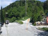 2
2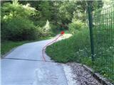 3
3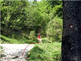 4
4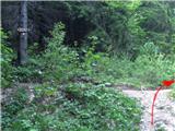 5
5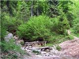 6
6 7
7 8
8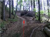 9
9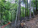 10
10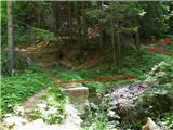 11
11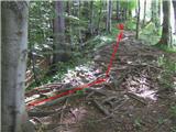 12
12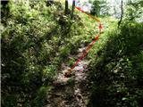 13
13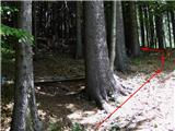 14
14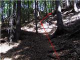 15
15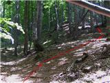 16
16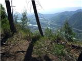 17
17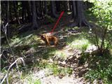 18
18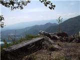 19
19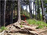 20
20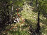 21
21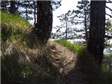 22
22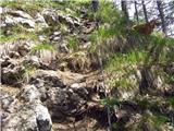 23
23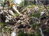 24
24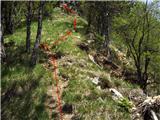 25
25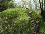 26
26 27
27
Discussion about the trip Jesenice (Ukova) - Jelenkamen (via Kalvarija)
|
| Darxta13. 01. 2013 |
heinz, excellent description and photos!! Really exemplary! 
I would point out 2 things:
1.) Between picture 7 and 8 there is a small junction where an arrow is drawn on the tree above the blaze directing us left up the slope, but actually we must take the cart track on the right.
2.) At the top they cut down a couple of trees, the view is phenomenal!
|
|
|
|
| heinz13. 01. 2013 |
Thanks Darxta!
I don't know which junction you mean, probably the one between the footbridges (picture 6 and 7), where one path turns left north up the slope. That leads to the old Jeseniški rovt (past the water intake, unmarked). Between 7 and 8 picture I think there is no junction.
In the description it says as you say: "...which quickly brings us to the first footbridge (Ukova stream), over which we come right to the second. After it the path or cart track goes right up the slope, then increasingly left towards east.."
Yes at the top it's "cleared" or sawn for the view. There was no more than one person who did it.. New (about 1 year ago) are also the bench and the box with the logbook which already has nearly 1000 entries.
Best, H!
|
|
|
|
| Darxta18. 01. 2013 |
OK, let me correct myself a bit: it's not exactly a junction, but an arrow on the tree points as if you have to go uphill, we just stick to the cart track (so no one gets confused if they go first)
|
|
|
|
| Edina18. 01. 2013 |
Hi heinz, if I had this description last month, I definitely wouldn't have gotten tangled up like this
http://stezeinsledi.blogspot.com/, (I didn't have internet access), but it turned out fine anyway. I'll surely return, and to many other nice paths around here too.
|
|
|
|
| heinz18. 01. 2013 |
Judging by the pictures, you didn't get too "tangled" Edina! Nice ones, no doubt! :-)
|
|
|
|
| tango12. 12. 2018 |
Perfect for late autumn. The path is in good condition, just a pity that my wife and I didn't have time to extend it into a loop to Španov vrh and back to the starting point. Recommended!
|
|
|
|
| Jusk10. 03. 2020 |
This afternoon I went along this trail and further, to Jelenkamen the path is a bit muddy and slippery, but ok, further along the ridge a few centimeters of snow appear. I continue to Lenčkov špik and further along the road, at the junction for Španov vrh and Pristava I choose Pristava, because towards Španov vrh there was a poorer track at this junction snow already around 20cm. Went towards Pristava, further towards Jelenkamen and back via Dole, also on this path there's still some snow.. Regards
|
|
|
|
| Jusk16. 10. 2020 |
Today again on this path back to the valley did a loop Ukova-Jeseniški rovt-Lenčkov špik-weekend settlement above Pristava-Jelenkamen-Ukova. After rain most of the path is muddy and slippery, weather today also didn’t offer views, on Jelenkamen and already before on the ridge fog.. but next time
|
|
|
|
| Jusk27. 10. 2020 |
a quick trip today after work, darkness comes early.. after today's rain the whole path very muddy, water flowing on some sections.. especially that last steepest slope very slippery especially downhill on descent.. and again no view, fog started soon after the chapel at Kalvarija
|
|
|
|
| Jusk8. 11. 2020 |
today this path was insanely full of people, many Jesenice locals hike up here, especially on such a beautiful day as it was.. in the company of 4 colleagues the path passed quickly views from the top super
|
|
|
|
| Jusk9. 11. 2020 |
today just the opposite of yesterday, only a few people on the path, great view from the top, our valley all in sun, towards Kranj a wall of fog..extended the path to Lenčkov špik and back down via the road to Prihode. Regards
|
|
|
|
| Jusk3. 12. 2020 |
this afternoon when I went up the path was already nicely trodden, a bit more caution needed in the last steepest part of the path..from the top onwards only the track of one who was returning via Dole like me. snow around there almost to the knees..but the whole loop was real winter idyll
|
|
|
|
| Jusk6. 01. 2021 |
today the trail was already well trodden, at least to Kalvarija, further towards Jelenkamen a bit less, but there were already some new tracks in the fresh snow. otherwise the trail is fine, but caution is needed in the last steep section, a bit of climbing is required, the rope for grip is not much, about half is under snow..at the top the trail ends, further towards Pristava there is no track. Lp
|
|
|
To post a comment you must log in:
If you do not yet have a username, you must first
register.