Drežnica - Krn (Silvo Koren route)
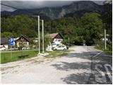
Starting point: Drežnica (553 m)
| Latitude/Longitude: | 46,2555°N 13,617°E |
| |
Route name: Silvo Koren route
Walking time: 5 h
Difficulty: very difficult marked way
Elevation gain: 1691 m
Elevation difference along the route: 1691 m
Map: Julijske Alpe - zahodni del 1:50.000
Recommended equipment (summer): helmet, self belay set
Recommended equipment (winter): helmet, self belay set, ice axe, crampons
Views: 123.349
 | 13 people like this post |
Access to starting point:
From Tolmin or Bovec we drive to Kobarid, from there we follow the road in the direction of Drežnica (the turn-off from the Kobarid bypass). We continue across the bridge over the river Soča and immediately after the bridge we turn left in the direction of Drežnica. We then follow this mostly ascending road to the center of Drežnica, where we turn right and drive on to the primary school, which is the starting point of our path.
Route description:
From the parking lot, we head past the chapel and primary school on the marked path to Krn. Further on, the path leads through the forest and then along the pasture to the Triglav National Park sign. Here the path along the road also joins (road from Drežnica), but we continue on the marked path, which a little higher crosses the Ročica stream, after which we arrive at a marked junction, where we continue left towards the bivouac and the very demanding path to Krn (right the easier path to Krn).
The path ahead enters a dense forest, through which it moderately ascends alongside the Ročica stream. Further on, the path turns slightly right and leads us to the Bivak na Črniku.
From the bivouac, we continue sharply left and continue the ascent along the path ascending through the forest. When after a few minutes of further walking we step out of the forest, we turn slightly left, then after a short crossing of the slopes below the Krn walls we arrive at the start of the climbing section of the path.
Already at the start of the climbing section, with the aid of pegs and a steel cable, we ascend almost vertically up the rocky slope. After a short very steep ascent, the path turns gently left and for a short time becomes somewhat less demanding. This is followed by an ascent along the cable and then a zigzag ascent up a very steep and unprotected grassy slope (when wet there is a very high risk of slipping on this section, and even when dry considerable caution is required). The path then turns right and brings us to a marked junction.
The right (Zahodna drežniška) path crosses the exposed western slopes of Krn and later joins the path from the Kuhinja pasture and the easier path from Drežnica, while we continue left towards the Silva Korena path.
Further on, the path runs along a very steep and exposed ridge, which is well protected. This path then takes us to the logbook box with the logbook, located before the most exposed section of the path. The path continues along a relatively narrow and precipitous ridge, where we climb two vertical ladders. This is followed by a few very steep ascents along the cable, after which the path levels out and takes us to the Gomiščkovo zavetišče na Krnu hut.
From the hut, we continue towards Krn, which we reach after about 10 minutes of further walking.
We can descend via the easier southern path.

Photos:
 1
1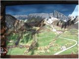 2
2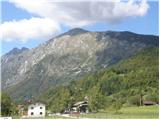 3
3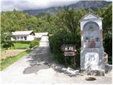 4
4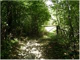 5
5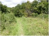 6
6 7
7 8
8 9
9 10
10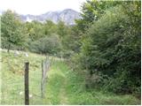 11
11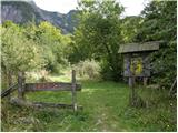 12
12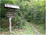 13
13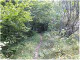 14
14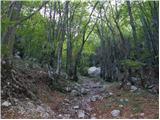 15
15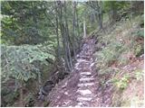 16
16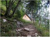 17
17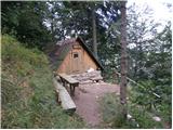 18
18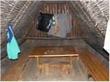 19
19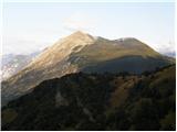 20
20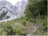 21
21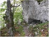 22
22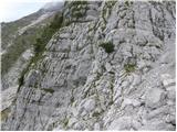 23
23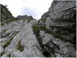 24
24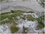 25
25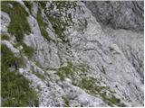 26
26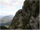 27
27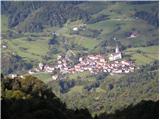 28
28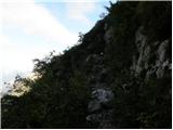 29
29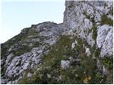 30
30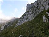 31
31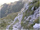 32
32 33
33 34
34 35
35 36
36 37
37 38
38 39
39 40
40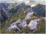 41
41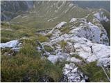 42
42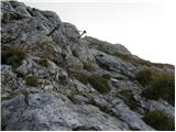 43
43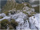 44
44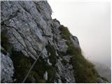 45
45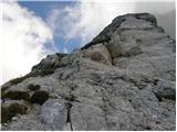 46
46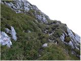 47
47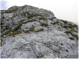 48
48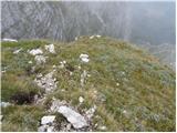 49
49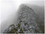 50
50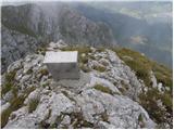 51
51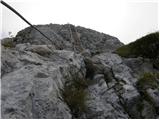 52
52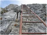 53
53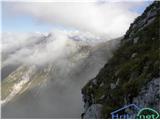 54
54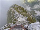 55
55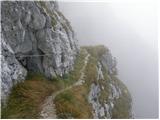 56
56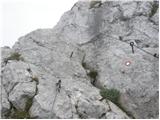 57
57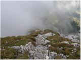 58
58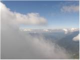 59
59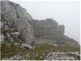 60
60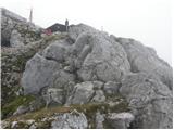 61
61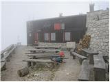 62
62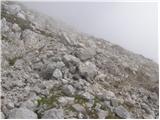 63
63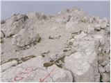 64
64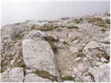 65
65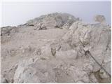 66
66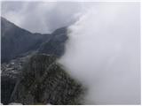 67
67
Discussion about the trip Drežnica - Krn (Silvo Koren route)
Show older messages
|
| Gost9. 06. 2007 |
The hike is really proper and requires the whole person. The path itself is varied (meadows, forest, streams, snowfield, scree...) and tense all the time, but from the bivouac at Črnik onwards it needs clearing of the rocks that have fallen on the path. In the metal box on the Silva Koren path, the logbook has been full for quite some time. No sign of the stamp. PD markacists? hello. Praise goes to the Drežničari for the nicely arranged bivouac and the path to it.
Tine
|
|
|
|
| Gost2. 07. 2007 |
Really a proper hike, this year 7.7 2007 we are going for the third time traditionally, which we will of course continue in the future.
The mountain really sharpens all senses, besides the Korens path also the history of Krn, because a person who knows the history of the Soča front gains respect for the mountain. Whenever I head to Krn, I think of the soldiers dug into caves, who gave their lives, youth to the mountain, soldiers who fought for our future, we must be aware of this fact and never forget.
Via Korens to Krn is not just a trip to the mountains, it is an experience when you think about what the soldiers did up there at all and of course what you are doing now, so safe steps and good luck! Aljaž Pirš
|
|
|
|
| Gost2. 07. 2007 |
Yes really Aljaž ... just being near that mighty mountain and trying to imagine what the boys of all nationalities suffered up there to think ... in the hope that it will never happen again ... Good luck, Aleš
|
|
|
|
| LISO21. 07. 2008 |
On Saturday I climbed Korenova, which I recommend to everyone. Fun and exposed. A little snow at the start (a few steps), protections excellent. In five hours anyone can really comfortably reach the top.
|
|
|
|
| grahlck19. 07. 2009 |
Is there any snow on this path? I'm heading out next Sunday via the climbing path to Krn and back via the mulatiera.
|
|
|
|
| grahlck19. 07. 2009 |
One more thing interests me. How are the fixed protections? Are they in good condition?
|
|
|
|
| triglavski19. 07. 2009 |
LISO, a bit above it's written that the protections are excellent, sun hasn't melted them either.
|
|
|
|
| silva17. 08. 2009 |
So... we made it too. The hike requires two hours of active movement in the wall, adrenaline is plentiful, for the icing on the cake - and then a slippery bit. On the top everything is rewarded. Really varied and exciting path. Really varied and exciting path.
|
|
|
|
| maiden3. 10. 2009 |
one question...
On this trail you can nicely attach the self-belay kit, right?
|
|
|
|
| ksena3. 10. 2009 |
You can use it, since there are steel cables at all more exposed places. I personally never use protection on this trail, however.......of course I'm not bragging about it and it's not to my honor. Good luck.
|
|
|
|
| maiden3. 10. 2009 |
The fact is I don't have the set (yet) and I'm wondering where it can be used and here it can be used =)
|
|
|
|
| ksena3. 10. 2009 |
If you plan to learn to use it on this trail and you've climbed secured trails "without a set" so far, you'll probably manage this too. I'm talking about technique, not about possible objective danger that doesn't go away, but this set can save you (slip..).Better train on the stair railingand then go on the trail if you want to start using the set.
If I compare trails... the S. Koren trail to Krn could perhaps be compared to the Slovenian one on Mangart at certain points.
|
|
|
|
| maiden3. 10. 2009 |
Well yeah, you have to start somewhere=)
The hardest trail for me was to Bavški Grintavec. I would really like to try some ferrata where you can attach the set.
For example on Mangart via the Slovenian one I haven't gone yet...
|
|
|
|
| Bizy21. 10. 2009 |
Really beautiful enjoyable and tense path, it keeps you alert all the time - done on Tuesday 20.10 in fog, on grassy steep slopes with snow dust, lucky wire ropes and slippery spots. Delights...
At the top of Krn though magnificent views in the wind.
|
|
|
|
| lozarbogdan8. 06. 2010 |
I'm interested in how the Silva Korena trail fared through the winter. Condition of the protections? Has anyone been up there recently? I'd go on Sunday. Thanks for the reply.
|
|
|
|
| lozarbogdan8. 06. 2010 |
I wonder how the Silva Korena trail has endured the winter. Condition of the safety gear, has anyone been up there recently. I would go on Sunday. Thanks for the reply.
|
|
|
|
| lozarbogdan8. 06. 2010 |
I wonder how the Silva Korena trail has endured the winter. Condition of the safety gear, has anyone been up there recently. I would go on Sunday. Thanks for the reply.
|
|
|
|
| jlogar8. 06. 2010 |
I'm also interested whether there's still any snow on the Silva Korena trail and whether the hut on Krn is open.
|
|
|
|
| grega_p9. 06. 2010 |
I walked the trail on 30.5. and it was mostly dry - except at the start of the wall entrance, where there was a larger snow patch (passable without crampons) and another small one 15 min before the western trail branch, no major issues. Safety gear condition is good, but on scree be careful where there are none.
The hut should open this weekend per my info, but better call 051 688 684 (Kobarid mountaineering club)
Enjoy your time up there!
Grega
|
|
|
|
| lozarbogdan9. 06. 2010 |
Grega thanks for the info, nice moments to you too wherever you are!
|
|
|
|
| starakapa9. 06. 2010 |
I hiked the Silva Korena path today and can tell you everything is OK, now there's no snow anymore either. The shelter is OPEN
|
|
|
|
| lozarbogdan10. 06. 2010 |
starakapa thanks for the info best regards Bogdan!
|
|
|
|
| lepenatka6. 09. 2010 |
Hopefully this weekend the good forecast will finally come true, the Silva Korena path tempts me... Has anyone hiked there recently? How is the condition?
Thanks for any response.
|
|
|
|
| ksena6. 09. 2010 |
I "climbed" this path recently. The snowfield before entering the wall is short, passable, the fixed protection along the entire path is OK. Given that the path is shady for half the day, there is - right after rain and also early in the morning - an even greater risk of slipping. Otherwise, on the secured sections you can use self-belaying, on the unsecured sections (especially grassy ones) just step a bit more carefully. Good luck on this really beautiful path.
|
|
|
|
| lepenatka6. 09. 2010 |
Thanks Ksena for the quick response.
|
|
|
|
| lepenatka12. 09. 2010 |
Ksena, really super tour and wonderful day. And the lingonberries are still growing.
|
|
|
|
| gregson22. 09. 2010 |
Today I was on Krn via Silva Korena path, but no lingonberries anywhere anymore the day was more than excellent and really a very nice hike with quite some adrenaline....
|
|
|
|
| dedo2424. 06. 2011 |
Has anyone gone up the Silva Korena path to Krn recently, is there still any snow?
|
|
|
|
| ksena24. 06. 2011 |
Snow is only just before entering the gully. The tongue is about 10m wide. Otherwise everything is fine on the S. Korena route. Good luck.
|
|
|
|
| dedo2429. 06. 2011 |
Ksena, thanks for the reply. On Sunday we went to the summit via Silva Korena path. Wonderful adrenaline path.
|
|
|
|
| ales5030. 06. 2011 |
The path to Krn is wonderful and full of traces of the war that raged there at that time, interesting historical and beautiful hike,
|
|
|
|
| ksena30. 06. 2011 |
You notice even more war remnants if you go from Krn across Batognica towards Rdeči rob or to Krnska škrbina, then left towards and along Krnčica to Vrata and then to planina Zapleč or Zaprikraj above Drežnica.
|
|
|
|
| jax17. 09. 2011 |
Today finally up there. The lower part is quite tricky, it was wet, steep grass, overall unsecured, terribly psychologically demanding, you never know when you'll fly over the wall ... But in the end I didn't 
At the junction I decided that I've had enough steep grass and jumped up over the rocks and Korenova. This one, on the contrary, is super. Super secured and just right difficult, only one cable a bit harder already high up under the summit. The lojtres are super Summit in clouds, but still - you could see to the lake, something to eat at the hut too. Good 4 hours up, about two for descent via the eastern. In the lower part (to the bivouac) it could be better marked in some places (especially around the path junction), but it can be found.
Otherwise - serious mountain tour, tremendous elevation gain, lower part distinctly psychologically strenuous, upper part also technically quite demanding. It can be done without self-belaying, but you'll probably be a bit calmer if you take the full gear. But interesting, worth visiting. Just find a day when the western Drežnica is dry, so the ascent is at least a bit calmer. The day was well used, now cooling is coming anyway ...
|
|
|
|
| CarpeDiem24723. 09. 2011 |
Very nice trail (personally maybe the nicest). I have been to Krn from all three directions (from Lepena, Drežnica and Planina Kuhinja). The trail is definitely not suitable for vertigo sufferers, also requires considerable fitness as a lot of elevation difference needs to be covered. I recommend descent via the easier (more southern trail), which also leads to the starting point in Drežnica!
|
|
|
|
| stankos23. 09. 2011 |
From Planina Zaprikraj it's also not bad.
|
|
|
|
| ales5024. 09. 2011 |
I only went from Lepena because I don't know other paths, but I'd go the other path, more interesting one that doesn't drag on so much to the lake, from Planina Zaprikraj I haven't gone yet, it's definitely longer if I'm not mistaken, best regards
|
|
|
|
| acjom13. 06. 2012 |
Does anyone have info if there's still snow on the Silva Korena path to Krn?
|
|
|
|
| martinkrpan13. 06. 2012 |
My wife and I are going to Krn around July 15th. A year ago we were at Krn Lake and in the distance was this special and interesting peak. The year before we saw it from Drežnica. I have to say that in our 60s, we're a bit afraid of heights but the desire is stronger. We're interested in an easier and less demanding path. Can someone help us with advice?
|
|
|
|
| miri13. 06. 2012 |
@martinkrpan Why not go from Planina Kuhinja and over Batognica and Peske past Lužnica back to the start?
|
|
|
|
| CarpeDiem24713. 06. 2012 |
@MartinKrpan, I would recommend starting from Planina Kuhinja (by car to there), then past Gomiščikovo zavetišče to the top of Krn, there's also an option over the saddle and first to the top and only on the descent down past the hut. This route is not "dizzying" and practically completely safe.
|
|
|
|
| IgorZlodej13. 06. 2012 |
The most beautiful path to Krn is from Lepena to Krn Lake and further to the top, if it's too much, you can also overnight at Krn Lake.
|
|
|
|
| CarpeDiem24713. 06. 2012 |
Yes, that one is really nice, I admit - it's also my favorite compared to from Planina Kuhinja. The one from Lepena is also not demanding, but considerably longer, for sure.
|
|
|
|
| ales5014. 06. 2012 |
Nice pictures, I'm interested if anyone noticed any quartz crystals on the path, where there's lots of rocky terrain and scree.
|
|
|
|
| martinkrpan14. 06. 2012 |
Thanks to everyone who sent replies or advice. Now to the map and route planning.
Best regards from Croatia.
|
|
|
|
| nominator28. 06. 2012 |
I'm going up tomorrow. Start around seven in the morning. Does anyone want to join?
|
|
|
|
| nominator30. 06. 2012 |
To describe a bit. I climbed the path in four hours. The path is nicely marked and well secured. On my difficulty scale from one to five I'd give it 3-4. My opinion is that the path to Jalovec from the shelter under Špičko is much more demanding. Regards
|
|
|
|
| Matjaz_656. 08. 2012 |
some photos from ascent via S. Korena and descent via southern path
|
|
|
|
| petradusty16. 08. 2012 |
Yesterday my friend and I did the ascent on the described path. Up to the saddle where the Western path branches off we had nice shade and climbing was fun despite the heat. The last 400 meters though we enjoyed dizzying views in the sun. The best was that we were the only ones in the wall and thus without falling rocks. The route is excellently secured and nicely routed. The most dangerous is on the intermediate steep grass slopes where there is no protection and you have to be careful. We too peeked at Gomiščkovo zavetišče in 4 hours.
|
|
|
|
| jax16. 08. 2012 |
The route is excellently secured and nicely laid out. The most dangerous part is on the intermediate steep grassy slopes, where there is no protection and caution is needed.
A slight oxymoron, isn't it?
I'll be a bit less lenient - Koren's path is okay, but overall definitely NOT excellently secured. The upper part yes, but below there should definitely be some wire on the traverse too. I have the feeling that some in Slovenia think grass can't be protected. It can. Go take a look abroad.
|
|
|
|
| Sopke9. 09. 2012 |
I completely agree with Jax.
|
|
|
|
| NINICA18. 09. 2012 |
Has anyone been to Krn recently? What are the conditions?
Thanks for replies!
N.
|
|
|
|
| ales5019. 09. 2012 |
Ninica, don't complicate, take gear and warm clothes and action, we can go together,
|
|
|
|
| BT8819. 09. 2012 |
Yeah jax that would be best, if they pull a cable from the glacier below to the top
|
|
|
|
| NINICA19. 09. 2012 |
Gladly ales50! Have you been up there already?
I'm just worried about the snow.
N.
|
|
|
|
| ales5019. 09. 2012 |
I've been there already, twice and to Batognica, so send me your contact phone and we can arrange,
|
|
|
|
| jax19. 09. 2012 |
BT88: you're the man. Will it be okay? Oh, by the way: which glacier did you have in mind? Triglav's? Or maybe the Aletschgletscher?
Now I'd really ask you something: how would you explain the fact that e.g. Italians on Via Amalia didn't secure only the wall below, but also the grass above? The fact is that on Koren's the most dangerous part is not secured. Period.
|
|
|
|
| BT8820. 09. 2012 |
Jax I meant snowfield sorry. But I'm the man anyway
|
|
|
|
| markc18. 10. 2012 |
What are the conditions on this path? Is winter gear mandatory?
|
|
|
|
| andraz8518. 10. 2012 |
I also plan to go on this path on Saturday... I've been monitoring temperatures in the last few days and they've been consistently above 0°C. In my opinion, any possible snow has melted, but another opinion is certainly not superfluous otherwise we'll turn back
|
|
|
|
| BT8819. 10. 2012 |
Andraz85 if you have no problem with turning back then go ahead. Otherwise this is the shadier side so even in summer when there's no sun it gets a bit cold. Good luck
|
|
|
|
| andraz8519. 10. 2012 |
markc, if you happen to read this today... I called a friend who has a friend who knows a friend in Drežnica. And that last friend from Drežnica said that the path is 100% dry. Maybe we'll meet tomorrow on the path
|
|
|
|
| markc20. 10. 2012 |
Andraz85 Thanks for the information.
|
|
|
|
| penuša30. 01. 2013 |
I'm interested if this path is more difficult than Tominškova to Triglav.
|
|
|
|
| SPIDER30. 01. 2013 |
Whether the path is more difficult I don't know, but structurally it's different. Most of the path runs along grassy ledges without protection and you have to be careful of slipping (wet grass). In the rock itself there is protection where needed (two short ladders) and that's it. Also, late spring the entry to the wall can be a bit delicate with a snow patch.
|
|
|
|
| jax30. 01. 2013 |
I would say it's a grade more difficult. The main reason spider already mentioned (slipperiness, exposure, long unprotected sections), and also higher up in the rocks it goes quite steeply up in a few places. True, I haven't been on Tominškova for quite a while, but I don't remember it going so steeply up anywhere.
|
|
|
|
| turbo30. 01. 2013 |
Those wet grasses are a problem also because the black greasy soil sticks to the soles when it is wet there.
|
|
|
|
| penuša3. 02. 2013 |
Thanks, SPIDER, jax and turbo, I'll wait for nice weather sometime in summer and set off on this tour.
|
|
|
|
| Lunca5. 02. 2013 |
I definitely recommend penuša... this tour remained in my memory as one of the nicer ones... Just wait for ideal conditions
|
|
|
|
| rogoza13. 05. 2013 |
and who knows what the conditions are like on the Silva Korena path?? Any more demanding snowfields? Thanks!
|
|
|
|
| ksena13. 05. 2013 |
Before entering the wall there is a snowfield. It is wide and long enough that you need winter gear to cross (risk of slipping). Also elsewhere there are grasses and grassy ledges where the path is not secured, after all the rain certainly well soaked and there too there is a risk of slipping. Good luck.
|
|
|
|
| rogoza13. 05. 2013 |
Ksena, thanks! I'll rather wait another 2 or 3 weeks until at least the grasses are dry.
|
|
|
|
| ksena13. 05. 2013 |
Smart decision...the mountain always waits, right? Best regards and safe steps wherever you go
|
|
|
|
| pohodnica07730. 06. 2013 |
Today I first climbed the Silvana Korena route without protection. It was completely dry, good to have a helmet, cables are fine, I enjoyed it because the weather held 
|
|
|
|
| madronščica1. 07. 2014 |
Hello... I would like to ask if there is still any snow on the Silva Korena path and what the path condition is, if someone has gone up recently.
Thanks and Good luck
|
|
|
|
| Ruzowski1. 07. 2014 |
Snowfield approx. 30 meters before entering the climbing section. That's all regarding snow. (on 28.6.)
|
|
|
|
| madronščica3. 07. 2014 |
Thanks for the forwarded information LidijaJesih on Ruzowski and good luck on all paths!
|
|
|
|
| fabcic1211. 06. 2015 |
Impressions from Sunday's ascent to Krn
On Sunday we decided to ascend Krn via this route. The path is in good condition, here and there a cable is poorly attached and some peg loose.
No snow, except a small snow patch just before the cables start (about 10m to cross on snow, that's it).
|
|
|
|
| alexandra30. 07. 2015 |
We plan to visit this path on Saturday. But we have some concerns mainly due to the heavy rain in the past days. We would only go in dry conditions, as steep grass when wet can be very dangerous. Do you think tomorrow's dry Friday will be enough for the path to dry by Saturday? We could go on Sunday instead, which might be smarter (sunny Saturday will probably overcome the wetness), but Sunday forecasts rain again.
Thanks for help
|
|
|
|
| macrofocus15. 08. 2015 |
Unfortunately this path proved its difficulty and unforgiving nature again yesterday. I would ask someone who knows the circumstances of the fatal accident if they can explain the cause and location thereof for the purpose of preventing a repetition of the tragedy. I would ask someone who knows the circumstances of the fatal accident if they can explain the cause and location thereof for the purpose of preventing a repetition of the tragedy.
|
|
|
|
| ales5015. 08. 2015 |
The mountain is not crazy, the person is who goes to Krn in inappropriate conditions, definitely not in rain because of lightning, hard to dry in one day as moisture stays longer at altitude, rocks slippery and fog, nonsense to go to the top in such conditions
|
|
|
|
| xyzxyz19. 08. 2015 |
is this path comparable to the path to Triglav, to the path to Vrbanove špice, to the path to Jalovec....
|
|
|
|
| jax19. 08. 2015 |
Well, Korenova is not overly demanding, but still - for all the paths you mentioned, it applies that they are secured at all more dangerous spots. But Korenova ... I'd rather not comment.
|
|
|
|
| xyzxyz19. 08. 2015 |
Thanks.
If I understand correctly, here you are more left to yourself, i.e. the path goes through open terrain and is not secured everywhere where it should be?
|
|
|
|
| xyzxyz19. 08. 2015 |
What if we compare it to the via ferrata on Visoka Ponca, or to the Turski Žleb, or to the path from Turska gora over Brana...
|
|
|
|
| Tinka2719. 08. 2015 |
The S. Korena path is great from my perspective, but it MUST be dry. The path in it when wet is... I won't say it out loud, but I'm also wondering if there were any special circumstances, otherwise it's... The path is not for beginners, it also requires fitness because it's long. I can easily compare it to Plemenice.
|
|
|
|
| xyzxyz20. 08. 2015 |
Thanks.
From what I hear, the path over Plamenice is scary or extremely demanding. So this one won't be for me.
|
|
|
|
| Smetar20. 08. 2015 |
Do you know the Furlan path to Gradiška tour? S. Koren path is comparable to Gradiška tour only that it is substantially longer and also has lojtra which are no "boo boo"...
Plemenice (B. path) is (a bit) more exposed and you need to master the rule of three support points, since there is no fixed cable everywhere as on via ferratas.
S. Koren path should of course be done in dry weather (so the path is dry), because otherwise it slips... of course fitness and knowledge of movement on very difficult paths is needed...
Good luck
|
|
|
|
| jax20. 08. 2015 |
Nicely put. The Gradiška tour is poetry in good rock. Koren's is dragging through tufts of grass. Really - they couldn't be more different.
|
|
|
|
| xyzxyz20. 08. 2015 |
Thanks to both, but can you two also tell me which path it is similar to?
|
|
|
|
| xyzxyz20. 08. 2015 |
But can someone tell me what is less demanding: THIS path or the path to Mrzla gora?
|
|
|
|
| jax20. 08. 2015 |
Okay, if you're already asking for comparison: rock sections somewhere in the range of the Slovenian one on Mangart, plus quite a few unprotected traverses on steep grasses. If that helps you. I think there's no other like it with us.
|
|
|
|
| Ruzowski20. 08. 2015 |
What could be highlighted on this path?
*snowfield at the entrance to the climbing section, which can last late into July
*most exposed part: approach to the ladders and path through them
*moisture, dew, is a constant on this path.
To me the grasses don't seem problematic. They are very, very problematic if we leave the path somewhere in the middle and cross instead of on the secured one towards that path coming from Kuhinja and easier from Drežnica. (I think it's the western Drežnica one)
Go boldly.
|
|
|
|
| xyzxyz20. 08. 2015 |
Thanks to everyone.
Always, when I go on a new more exposed path, I have respect for it.
|
|
|
|
| Maemi21. 08. 2015 |
Recently I went on it for the first time, also with respect for it. I don't recommend it after rain when everything is soaked, for those afraid of heights (walking on a narrow ridge) and for the inexperienced.
Otherwise, go boldly, this path was beautiful for me
|
|
|
|
| xyzxyz21. 08. 2015 |
Thanks for the encouragement.
With which ridge is this comparable?
|
|
|
|
| Maemi21. 08. 2015 |
Hard to compare this ridge because it has its own character. In places the path reminds me of the section of Lojze Rekar's path to Vrbanove Špice, but only that initial part to the rocky ridge. Everyone sees with their own eyes and makes rough comparisons...
|
|
|
|
| Ceri30. 08. 2015 |
Definitely an unforgettable tour and worthy of respect! In wet conditions deadly dangerous due to the combination of steep grass and scree. I've already climbed many things in our mountains, but I admit that on the lojtr'ca my knees were a bit soft. Otherwise a real climbing treat!
|
|
|
|
| benja815125. 09. 2015 |
Does anyone know if Krn has also got snow these days?
|
|
|
|
| MI&DA23. 08. 2016 |
If I am not mistaken, it was recently stated that the S.K. path is closed.
Can anyone provide information on the current status?
|
|
|
|
| MI&DA23. 08. 2016 |
Sorry
I was looking at several variants for this forecasted nice weekend and mixed up the information...
Bavški Grintavec via saddle Kanja - this one is due to landslide, officially still closed, but as I read, it is passable...
|
|
|
|
| darinka423. 08. 2016 |
But very crumbly especially towards the top.
|
|
|
|
| darinka423. 08. 2016 |
Sorry. I made a mistake. I intended to write this for Bavški Grintavec.
|
|
|
|
| maks5724. 08. 2016 |
I'm wondering if there's still any snow on this trail and what the condition of the safety gear is.
Thank you kindly for the reply.
|
|
|
|
| ivostra25. 08. 2016 |
You won't see snow on this trail, except under the wall where the climbing section starts. Right there at this entry, a couple of pegs are pulled out, but no problems because of that. Further on everything is fine. I did the trail on 20.8..
|
|
|
|
| mirko12326. 06. 2017 |
On Saturday I went on this path. Before the via ferrata there are still 10 m of snow to cross, which doesn't slide and crossing is quite dangerous for slipping. About 50 m below the summit of the hut there is a stone of about 30 kg on the path that is close to rolling into the valley. I had enough to do with myself, so I didn't even try to remove it to safety. Otherwise, the path is excellent, and very boring back via the south side.
|
|
|
|
| cotro428. 06. 2017 |
With a friend we were there on 23.6.17 ..under the bivouac we met a wild boar about 10m along the path, we glanced at each other a bit, we behind the tree, he sprinting uphill brrr..yes before the entry there's a snow patch and it looked nasty so the buddy dug steps with a sharp rock and we got through without issues even though I was a bit skeptical at the start. Wet gloves at the entry not recommended because the handhold didn't grip but almost nothing and they went in the pocket. Trail without features except that rock mentioned by mirko123 I think it's under the lojtrami not sure exactly, and that it's physically demanding everyone knows anyway. Regarding that exposed section between cables some are exaggerating a bit at least from what I read in comments above it's not that deadly as written, it's steep no doubt but no one was grabbing tufts of grass etc descent yeah a pain especially the last hour when soles are already burning nicely ...
|
|
|
|
| azzur3. 08. 2017 |
We went on this path yesterday. Great tour with quite a bit of adrenaline at the entrance to the wall and in the last part. Great also because the whole wall is in the shade in the morning and you reach the top nicely cooled
|
|
|
|
| darinka419. 08. 2018 |
I was there today 19.8. First time from Drežnica. The path is very nicely laid out. Nowhere slippery. Path in sections, climbing parts too. Those 5 hours are realistic. I descended via the easier one because it was getting stormy and thundering in the afternoon. Didn't meet almost anyone.
|
|
|
|
| Matjaz1327. 07. 2019 |
I'm particularly interested in your opinion on the difficulty of the trail. Do I need a via ferrata set on the trail? So far, from slightly more demanding trails, I have climbed Jalovec from Špička, Mojstrovka via Hanzova, Kočna via Kremžarjeva, Storžič through Žrelo. On these trails, I didn't feel the need for protection and didn't use it. The Silva Korena trail is probably more demanding and it's good to have it at least in the backpack just in case. Thank you for your advice. Best regards.
|
|
|
|
| keti130. 07. 2019 |
I went on this path last September and it seemed to me mainly very airy, open, adrenaline-filled. There are no demanding technical details anywhere, but cliffs accompany most of the time, a large part of the path goes over steep grass where there is no protection, it must be tackled dry. Where there are rocky outcrops on grassy terrain, there are also cables. In my opinion, it's good to have a self-belay set with you and clip in where you feel necessary, I did at a few spots, even though I've walked many of our secured paths without protection. The path's length also gives it considerable weight in my opinion, as it's 2 hours walk to the start, followed by three hours of more demanding section, which is significantly harder than if the "climbing fun" is for one hour, I mean mainly mentally.
|
|
|
|
| azzey16. 06. 2021 21:37:39 |
Has anyone been there in the last few days?
|
|
|
|
| darinka417. 06. 2021 18:21:47 |
Today David Sivec was there. He says it's dry.
|
|
|
|
| jax17. 06. 2021 19:22:30 |
Really? I haven't been there, but I saw a photo of that side. I'd be very hard to believe that there's no snow patch left at the entrance.
|
|
|
|
| darinka417. 06. 2021 21:48:11 |
I asked him. He says he went from the summit down. And that there's still a patch of snow at the entrance. Now I don't know. Usually the snow there is hard and compacted, so it's hard to cross without winter gear.
|
|
|
|
| darinka426. 06. 2021 22:45:50 |
Today we went via Korenova. The fixed protection is okay. There's quite a lot of snow in the initial climbing section. Both of us used winter gear to cross it. There's a lot of dirt on this snow. You get through the mud. Further to the hut there's no more snow. The hut is open. A young friendly couple is there this year.
|
|
|
|
| taubi17028. 07. 2021 01:39:13 |
Does anyone know what the conditions are like on the Koreno path today? Actually, I'm interested for Saturday. Is there still snow?
|
|
|
|
| docepe228. 07. 2021 06:42:46 |
On this page there's a notice dated 20.7 that the path is temporarily closed. First check with the responsible PD if they've opened it yet.
|
|
|
|
| darinka428. 07. 2023 21:45:27 |
If anyone is going on Koreno's path, it's nicely passable. Down in the forest there are quite a few beeches on the ground. But the path is cleared. The wood is prepared if anyone wants to carry it to the bivouac at Černik. In front of the bivouac they set up a table and benches. The interior is also arranged. Water flows nearby anyway. Was there today.
|
|
|
|
| darinka414. 07. 2024 19:41:07 |
We were there today. It's nicely passable. No crowds. The parking lot in Drežnica was quite full. Then I learned that a larger group went up. The two of us with Maksijem were anyway last. Almost no one at the shelter or on the summit. Foreigners were hiking from planina Kuhinja in the afternoon up.
|
|
|
|
| cen15. 08. 2024 20:27:02 |
Does anyone have an idea why mapzs says 8h for this path? That's a 3h difference from what's written here (and what the comments agree on).
|
|
|
|
| Jure 217. 08. 2024 18:06:29 |
I assume. When you click up, it automatically marks the descent as well. I don't know why it does that.
|
|
|
|
| cen28. 06. 2025 10:32:57 |
25.6.2025 - before entering the climbing section there is still a snow patch which can be crossed without problems. Fixed protections OK, otherwise no peculiarities.
|
|
|
To post a comment you must log in:
If you do not yet have a username, you must first
register.