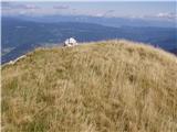
4444747.th.jpg) | Koča pri Savici - Kal (above Komna) (via Lepa Komna)
Kal is a panoramic peak between Lepa Komna and Zgornja Komna. From its summit, surrounded by dwarf pines, there are fine views of most Julian Alp...
5 h 5 min |
 | Dom v Lepeni - Veliki Šmohor (via planina na Polju)
Veliki Šmohor is a peak located south of Mali Šmohor and southeast of the idyllic mountain pasture Na Polju. From the summit, surrounded by numer...
4 h 30 min |
| Dom v Lepeni - Veliki Šmohor (via Mali Šmohor)
Veliki Šmohor is a peak located south of Mali Šmohor and southeast of the idyllic mountain pasture Na Polju. From the summit, surrounded by numer...
4 h 30 min |
 | Dom v Lepeni - Rdeči rob
Rdeči rob is a 1,913 m high mountain located in the ridge of Slemenske peči, which steeply descends toward the valley of the Tolminka River. From...
5 h 45 min |
 | Planina Polog - Kser (via planina Dobrenjščica)
Kser is a less prominent peak in the ridge of the Spodnje Bohinjske gore, more precisely between Tolminski Kuk and Mahavšček. From the summit, wh...
4 h 30 min |
 | Planina Polog - Vrh Škrli (via planina Dobrenjščica)
Vrh Škrli is a 1,926-meter-high mountain located above the Spodnja Komna plateau. From its grassy summit, over which the national border once ran...
4 h 35 min |
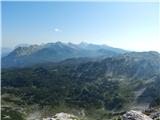
 | Planina Polog - Mahavšček (via planina Dobrenjščica)
Mahavšček, or Veliki Bogatin, is a 2008 m high mountain on the northwestern edge of the Lower Bohinj Mountains. From the summit, with its somewha...
5 h |
 | Soča - Vrh Leh
Vrh Leh is a 1958-meter-high mountain located between the Soča River valley and Bavšica. From the summit, on clear days a view opens up that is m...
3 h 30 min |
 | Soča - Pri Banderi
Pri Banderi is a 1974-meter-high peak located above Planina nad Sočo, more precisely in the ridge between Svinjak and Bavški Grintavec. From the ...
3 h 40 min |
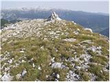
 | Soča - Vrh Ovčje planje
Vrh Ovčje Planje is a 1965-meter-high mountain that rises steeply south of the Bavšica valley. From the grassy summit, where a small cairn stands...
3 h 50 min |
 | Zadnjica - Vodnikov Vršac (Vršac nad Zadnjico)
Vodnikov Vršac, also known as Vršac nad Zadnjico, is a 2194-meter-high mountain that drops precipitously toward the Zadnjiški dol valley. From th...
4 h 55 min |
| Trenta - Vodnikov Vršac (Vršac nad Zadnjico)
Vodnikov Vršac, also known as Vršac nad Zadnjico, is a 2194-meter-high mountain that drops precipitously toward the Zadnjiški dol valley. From th...
4 h 55 min |
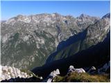
 | Grant - Suha Rodica (Novi vrh)
Suha Rodica (also known as Novi vrh) is a precipitous peak between Rodica and Črna prst in the ridge of the Lower Bohinj Mountains. From the summ...
4 h 15 min |
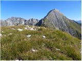
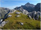
 | Grant - Mali Raskovec (via Rodica)
Mali Raskovec is a rarely visited peak between the somewhat better-known Veliki Raskovec and the little-known Suha Rodica. From its grassy summit...
4 h 30 min |
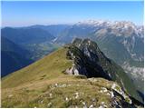
 | Grant - Raskovec (via Rodica)
Raskovec is a panoramic mountain between the more prominent Rodica and Črna prst. Its seldom-visited summit lacks a logbook or stamp but delivers...
4 h 30 min |
 | Koča pri Savici - Velika Baba (via Bogatinsko sedlo and Lanževica)
Velika Baba is the highest peak of the eastern ridge above Lepena valley. From the summit, which has a logbook, there are fine views of Krn and L...
6 h |
 | Dom v Lepeni - Lanževica (via Velika Baba)
Lanževica is a 2003 m high peak located between Bogatinsko sedlo and Oslova škrbina. From the summit, where remnants of the former Rapallo border...
4 h 40 min |
 | Ribčev Laz - Mala Rodica
Mala Rodica is an indistinct, partly grassy peak at the edge of Velika Rodica's summit pyramid. In fine weather, it provides nice views across th...
3 h 50 min |
 | Kapellen - Hoher Klapf
Hoher Klapf is a panoramic pathless peak in the Schneealpe mountain group, located near the group's highest peak, Windberg....
3 h 45 min |