 | Waldheimhütte - Zirbitzkogel (via Wildsee)
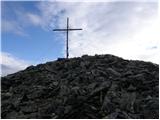
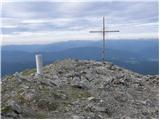
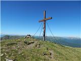
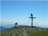
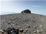
Zirbitzkogel, at 2,396 m, is the highest peak of the Labotniške Alpe / Seetaler Alpen. From the summit, where a cross and a panorama board stand,...
3 h 32 min |
| Waldheimhütte - Zirbitzkogel (via Rothaidenhütte)
Zirbitzkogel, at 2,396 m, is the highest peak of the Labotniške Alpe / Seetaler Alpen. From the summit, where a cross and a panorama board stand,...
3 h 7 min |
| Waldheimhütte - Zirbitzkogel (via Lavantsee)
Zirbitzkogel, at 2,396 m, is the highest peak of the Labotniške Alpe / Seetaler Alpen. From the summit, where a cross and a panorama board stand,...
2 h 47 min |
 | Waldheimhütte - Scharfes Eck (Direct way)
Scharfes Eck is a peak on which stands an Austrian meteorological radar station. From the summit, there is a beautiful view of the neighbouring p...
2 h 45 min |
 | Etrachsee - Bauleiteck
Bauleiteck is a panoramic peak located on the eastern part of the Schladminger Tauern mountain group. From the summit, where a cross stands, ther...
3 h 15 min |
 | Prebersee - Preber
Preber is a 2740 m high peak located in the heart of the Schladminger Tauern mountain group. The summit, where a cross stands, is a very popular ...
3 h 30 min |
 | Prebersee - Preber (via Mühlbachtörl)
Preber is a 2740 m high peak located in the heart of the Schladminger Tauern mountain group. The summit, where a cross stands, is a very popular ...
3 h 45 min |
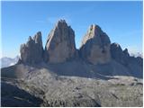
 | Piano Fiscalino / Fischleinboden - Croda Fiscalina di Mezzo / Oberbachernspitze
Croda Fiscalina di Mezzo, or in German Oberbachernspitze, is a 2675-meter-high mountain located in the heart of the Dolomiti di Sesto / Sextner D...
4 h |
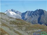
 | Volkzeinalm - Hochalmspitze (Villgraten)
Hochalmspitze is a 2797-meter-high peak located in the southwestern part of the High Tauern in the Villgraten mountain group. This peak is much l...
2 h 45 min |
 | Piano Fiscalino / Fischleinboden - Sasso di Sesto / Sextnerstein
Sasso di Sesto is a 2,539-meter-high peak located in the Sexten Dolomites Nature Park. This easily accessible peak offers exceptional views of th...
3 h 30 min |
 | Colfosco - Sas Ciampac
Sas Ciampac is a 2672-meter-high peak in the Puez group. From the summit, which features a small wooden cross, there is a nice view of the Puez g...
3 h 30 min |
 | Erschbaum - Pfannspitze / Cima Vanscuro
Pfannspitze / Cima Vanscuro is a 2,678-meter mountain in the western Carnic Alps. From its cross-topped summit, there are excellent views of the ...
4 h 45 min |
 | Passo Campolongo - Setsas
The Setsas peak is located west of the Passo Valparola pass and is somewhat distant from the highest summits. Precisely because of this remotenes...
3 h 40 min |
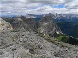
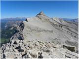 | Rifugio Pederü - L'Ciaval / Kreuzkofel (path 12)
L'Ciaval / Kreuzkofel is a 2,907-meter-high mountain in the Lavarella group. The mountain and the entire ridge it's located in are recognizable b...
4 h 45 min |
| Rifugio Pederü - L'Ciaval / Kreuzkofel (path 7)
L'Ciaval / Kreuzkofel is a 2,907-meter-high mountain in the Lavarella group. The mountain and the entire ridge it's located in are recognizable b...
4 h 50 min |
 | Sadnighaus - Sadnig (direct way (path 150))
Sadnig or Hoher Sadnig is a relatively easily accessible and panoramic mountain in the eponymous Sadnig group (German: Sadniggruppe), the souther...
2 h 45 min |
 | Sadnighaus - Sadnig (via mountain pasture Lindler (pot 149))
Sadnig or Hoher Sadnig is a relatively easily accessible and panoramic mountain in the eponymous Sadnig group (German: Sadniggruppe), the souther...
3 h 15 min |
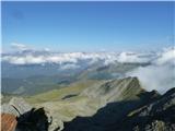
 | Sportgastein - Greilkopf (via Hagener Hütte)
Greilkopf is a 2,581 m high mountain in the Ankogel group of the Hohe Tauern in Austria above the town of Mallnitz. It is a popular winter destin...
3 h 45 min |
 | Plöckenhaus - Polinik (path 403)
Polinik is a 2,332-meter-high mountain in the Austrian part of the Carnic Alps near the mountain pass to Italy, the Plöckenpass.East of Polinik l...
3 h 15 min |
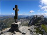
 | Turrach - Eisenhut
Eisenhut, at 2,441 meters, is the highest peak in the Gurktal Alps, which stretch across the basin of the Krka/Gurk River and descend to the nort...
4 h 30 min |
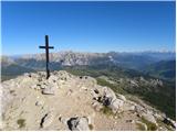
 | Turracher Höhe - Straßburger Spitz
Straßburger Spitz is a 2,404-meter-high peak located between the summits of Eisenhut (2,441 m) and Wintertalernock (2,394 m). From the top, where...
4 h 45 min |
 | Turrach - Straßburger Spitz
Straßburger Spitz is a 2,404-meter-high peak located between the summits of Eisenhut (2,441 m) and Wintertalernock (2,394 m). From the top, where...
4 h |
 | Turrach - Wintertalernock
Wintertalernock is a 2,394-meter-high peak located southeast of the highest summit of the Gurktal Alps, Eisenhut. From the top, where a cross sta...
4 h 15 min |
 | Kühtai - Sulzkogel (normal approach from Kühtai)
Sulzkogel is a panoramic, easy, and relatively quickly accessible three-thousander located above the well-known ski center Kühtai in the Sellrain...
3 h 30 min |
 | Passo San Pellegrino - Cima Juribrutto
Cima Juribrutto is a 2,697-meter-high mountain rising above the San Pellegrino Pass. It offers a nice view also towards the Valles Pass....
3 h |
 | Lakkos tou Mygerou - Agathias (Kreta)
Agathias is the fourth-highest mountain on the island of Crete in Greece, at 2,424 meters. Agathias (Gr. Αγκαθιάς) is located southeast of Timios...
3 h |
 | Nida - Timios Stavros / Psiloritis (Kreta)
Timios Stavros is Crete's highest mountain at 2,456 meters and also the highest among the Greek islands. Due to its topographic prominence, it is...
4 h 15 min |
 | Lakkos tou Mygerou - Timios Stavros / Psiloritis (Kreta)
Timios Stavros is Crete's highest mountain at 2,456 meters and also the highest among the Greek islands. Due to its topographic prominence, it is...
3 h |