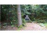
 | Polhov Gradec - Polhograjska Grmada (via Ravnek and via Sveta Uršula)
Polhograjska Grmada is an 898 m high peak located in the heart of the Polhograjski Dolomites. From the summit, where there is a registration box ...
1 h 50 min |
 | Rakovnik - Sveti Jakob (via Breznik)
The Church of St. James is located on a scenic hill north of the village of Topol pri Medvodah. From the summit, which features a registration bo...
1 h 50 min |
 | Gosteče - Osolnik (via Vidmovec)
Osolnik is an 858-metre-high mountain located south of Škofja Loka and west of Medvode. From the summit, where the Church of St Mohor and Fortuna...
1 h 30 min |
 | Hosta - Osolnik
Osolnik is an 858-metre-high mountain located south of Škofja Loka and west of Medvode. From the summit, where the Church of St Mohor and Fortuna...
2 h 10 min |
 | Sveta Barbara (Nova Hrastnica) - Osolnik
Osolnik is an 858-metre-high mountain located south of Škofja Loka and west of Medvode. From the summit, where the Church of St Mohor and Fortuna...
1 h 50 min |
 | Mlinše - Zasavska Sveta gora
Zasavska Sveta Gora is a popular excursion destination located between Litija and Izlake. From the summit, where the parish church of the Nativit...
1 h 30 min |
 | Vidrga - Zasavska Sveta gora (on forest footpath)
Zasavska Sveta Gora is a popular excursion destination located between Litija and Izlake. From the summit, where the parish church of the Nativit...
1 h 30 min |
| Vidrga - Zasavska Sveta gora (on a cart track)
Zasavska Sveta Gora is a popular excursion destination located between Litija and Izlake. From the summit, where the parish church of the Nativit...
1 h 30 min |
 | Sveta Barbara (Nova Hrastnica) - Sveti Ožbolt (above Zminec)
Sveti Ožbolt is situated on a panoramic rise in the north of the Polhograjski Dolomiti. There is a beautiful view toward the Škofjeloško hribovje...
1 h 40 min |
 | Hotovlja - Bukov vrh (by road)
Bukov vrh, where the Church of Our Lady of Sorrows stands, is located in the northwestern part of Polhograjsko hribovje. From the summit, there a...
1 h 30 min |
 | Planina (Dolnja Planina) - Petričev hrib (via Zavrtniki)
Petričev hrib is a peak north of Postojna and west of Planina. From the summit, which has a logbook box, there is a nice view of the Notranjska h...
1 h 35 min |
| Planina (Dolnja Planina) - Petričev hrib (via Sv. Duh)
Petričev hrib is a peak north of Postojna and west of Planina. From the summit, which has a logbook box, there is a nice view of the Notranjska h...
1 h 35 min |
 | Divje jezero - Hleviška planina (via Strug)
Hleviška planina (also Hleviške planine) is a slightly vegetated but still very panoramic peak. From the summit, the home mountain of Idrija, the...
1 h 45 min |
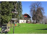
 | Slavkov dom na Golem Brdu - Rog
Rog is an 798-meter peak above the village of Topol, just 10 minutes from St. Katarina's Church. From the summit, where a large cross once stood,...
1 h 40 min |
 | Selca - Miklavška gora (by road)
Miklavška gora is a panoramic hill situated south of Železniki and Selca. From the summit, where the Church of St. Nicholas stands, a beautiful v...
1 h 45 min |
 | Podpeč - Grmada on Mala gora
Grmada (also Grmada above Ortnek) is an 887-meter-high peak located above the village of Vrh pri Poljanah in the Mala Gora range. Just a few mete...
1 h 35 min |
 | Zgornja Kungota - Tojzlov vrh
Tojzlov vrh is a forested hill on the eastern part of Kozjak. On the summit stands a small stone NOB monument and, more recently, also a summit l...
2 h 30 min |
 | Vitovlje - Hunting cottage below Čaven
The hunting cottage below Čaven is situated on a panoramic hill on a side ridge of Čaven. From the cottage, which serves as an emergency bivouac,...
1 h 50 min |
 | Zgornja Rečica (Maček) - Govško brdo (past shepherd's chapel)
Govško brdo is an 811-meter-high hill located west of the village of Huda Jama above Laško. From the summit, which features a logbook box and sta...
1 h 35 min |
 | Source of Ljubljanica (Močilnik) - Ljubljanski vrh
Ljubljanski vrh is an 819 m high hill located south of Vrhnika. The military has installed a radar observatory on the summit, so ascent to the ve...
2 h |
 | Polhov Gradec - Mala Grmada (via Ravnek and via Sveta Uršula)
Mala Grmada is an 853-meter-high peak located southwest of the slightly higher Polhograjska Grmada. From the summit, a beautiful view opens up ov...
1 h 35 min |
 | Zazid - Golič (direct way)
Golič is a grassy ridge extending from Kojnik to the Slovenian-Croatian border and continuing as the Žbevnica ridge on the Croatian side. Due to ...
1 h 45 min |
 | Selca - Sveti Mohor (Zabrekve)
The Church of St. Mohor is located on a 952 m high hill between Zgornja Besnica and Selci. From the church or its nearby surroundings, there is a...
1 h 40 min |
 | Knape - Sveti Mohor (Zabrekve) (via Hudi Laz, Flandrova pot)
The Church of St. Mohor is located on a 952 m high hill between Zgornja Besnica and Selci. From the church or its nearby surroundings, there is a...
1 h 40 min |
 | Cerkno - Veliki vrh (Lajše) (on unmarked path)
Veliki vrh is an almost 900-meter-high elevation rising south of Cerkno. From the summit, which features several television and radio transmitter...
1 h 40 min |
 | Cerkno - Škofje (on unmarked path)
Škofje is a 973-meter-high peak located above the villages of Čeplez, Planina pri Cerknem, and Podpleče. The summit itself, marked by a small con...
1 h 45 min |
| Nevlje pri Kamniku - Vovar
A viewless hill in front of the Kamnik mountains. In recent times, due to storms, it is crisscrossed with cart tracks for log extraction.Below th...
1 h 30 min |
 | Bottom station of Pohorje cable car - Pečke (via Meranovo)
Pečke is an easily accessible peak that has seen fewer visitors lately, located north of the main Pohorje ridge. It gets more visits only on May ...
2 h |
 | Jamce - Sončnica (Reber)
Sončnica is a paragliding site on the periphery of the Gora plateau or Reber ridge. At the take-off point, offering nice views towards the Vipava...
1 h 45 min |
 | Jamce - Kraguljc
Kraguljc is a mountain situated between Podrta gora and Sončnica. On the panoramic summit, from which nice views open towards the Vipava Valley a...
1 h 30 min |
 | Poljana - Andrejev vrh (over Volinjak and on cart track)
Andrejev vrh is a forest-covered peak located between Mežica and Leše. On the summit there is a bench and a summit register box with a logbook....
1 h 50 min |
| Poljana - Andrejev vrh (via Volinjak and past the chapel)
Andrejev vrh is a forest-covered peak located between Mežica and Leše. On the summit there is a bench and a summit register box with a logbook....
1 h 55 min |
| Poljana - Andrejev vrh (past Leše churches and on cart track)
Andrejev vrh is a forest-covered peak located between Mežica and Leše. On the summit there is a bench and a summit register box with a logbook....
1 h 50 min |
| Poljana - Andrejev vrh (via Leše churches and via chapel)
Andrejev vrh is a forest-covered peak located between Mežica and Leše. On the summit there is a bench and a summit register box with a logbook....
1 h 55 min |
 | Selca - Sleme (Površnica)
Sleme is a panoramic peak located between Rudno, Dražgoše, and Lajše. From the summit, where transmitters are located, there is a nice view of th...
1 h 35 min |
| Železniki - Sleme (Površnica) (via Štalca)
Sleme is a panoramic peak located between Rudno, Dražgoše, and Lajše. From the summit, where transmitters are located, there is a nice view of th...
1 h 35 min |
 | Rudnik pri Radomljah - Tolsta gora
Tolsta gora is a 734-meter-high mountain located above the settlement of Vrhpolje pri Kamniku. From the summit, where a cairn stands, there is no...
1 h 25 min |
| Pravdan - Tolsta gora (via Čeh)
Tolsta gora is a 734-meter-high mountain located above the settlement of Vrhpolje pri Kamniku. From the summit, where a cairn stands, there is no...
1 h 45 min |
 | Rudnik pri Radomljah - Vrtače (via Lancar)
Vrtače is a 758-meter-high peak located above the village of Zgornje Palovče. The summit is overgrown with forest, but from a clearing slightly b...
1 h 30 min |
| Pravdan - Vrtače (via Zgornje Palovče)
Vrtače is a 758-meter-high peak located above the village of Zgornje Palovče. The summit is overgrown with forest, but from a clearing slightly b...
1 h 45 min |
 | Dravograd (Meža) - Sveti Danijel (above Trbonje)
The Church of St. Daniel is situated on the edge of the Sveti Danijel settlement, above Trbonje. From the church, a nice view opens up towards Po...
1 h 30 min |
 | Škofja Loka - Vrh soteske (Križna gora)
Vrh soteske is a 735 meters high peak, which is situated on the southwestern part of Križna gora. From the top, which is overgrown by the forest,...
1 h 25 min |
 | Grahovo ob Bači (Brelih) - Črvov vrh (via Žrelo)
Črvov Vrh, also known as Črvov Grič, is the highest peak of the Šentviška Planota at 974 metres. The plateau rises above the right bank of the Id...
1 h 50 min |
| Grahovo ob Bači (Brelih) - Črvov vrh (via homestead Pušnik)
Črvov Vrh, also known as Črvov Grič, is the highest peak of the Šentviška Planota at 974 metres. The plateau rises above the right bank of the Id...
1 h 40 min |
 | Grahovo ob Bači (Brelih) - Bukovski vrh (via Žrelo)
Bukovski Vrh (918 m) lies above the settlement of Bukovski Vrh, more precisely above the Pri Pircu homestead. From the grassy summit there is a f...
1 h 40 min |
 | Hotavlje - Vrh Slajke (via Bela)
Vrh Slajke is a 790-metre hill above Hotavlje, specifically above the right bank of the Kopačnica. From the summit, where an antenna tower stands...
1 h 30 min |
| Podgora - Vrh Slajke
Vrh Slajke is a 790-metre hill above Hotavlje, specifically above the right bank of the Kopačnica. From the summit, where an antenna tower stands...
1 h 25 min |
 | Žiri - Krog (Ledinski grič)
Krog is a 940-metre-high peak on the western part of the Ledinski grič ridge, between the streams Jerešča and Ledinščicaboth left tributaries of ...
1 h 50 min |
 | Hotavlje - Špik (Vranškov grič) (via Bela)
Špik (also marked as Vranškov grič on maps) is a 908 m high mountain west of Hotavlje. The summit lies in forest, but a grassy subpeak offers fin...
1 h 50 min |
| Podgora - Špik (Vranškov grič)
Špik (also marked as Vranškov grič on maps) is a 908 m high mountain west of Hotavlje. The summit lies in forest, but a grassy subpeak offers fin...
1 h 45 min |
 | Hotavlje - Kucelj (above Kopačnica) (via village Studor)
Kucelj is a 920-meter-high peak located above the left bank of Kopačnica and the settlement of the same name. At the summit there is a bench, a t...
2 h 10 min |
| Hotavlje - Kucelj (above Kopačnica) (via Srednje Brdo)
Kucelj is a 920-meter-high peak located above the left bank of Kopačnica and the settlement of the same name. At the summit there is a bench, a t...
1 h 55 min |
 | Bresternica (Spodnji Rušnik) - Možičev vrh (via Žavcarjev vrh)
Možičev vrh is a 926-meter-high peak located west of the more famous but slightly lower Žavcarjev vrh. A cart track leads to the summit, but due ...
1 h 55 min |
 | Vas (sports field) - Sveti Jurij (Remšnik)
The Church of St. Jurij is located on a panoramic hill in the Remšnik settlement, which lies on the slopes of Kozjak. Opposite the church, next t...
1 h 45 min |
 | Ožbalt (dam on stream Črmenica) - Grilov vrh (on cart track)
Grilov vrh is a panoramic peak above the left bank of the Drava River, east of Ožbalt. The summit logbook stands by the transmitters on a grassy ...
1 h 40 min |
 | Selnica ob Dravi - Janžev vrh
Janžev vrh is a lesser-known peak located slightly off the marked path from Selnica ob Dravi to Sveti Duh na Ostrem Vrhu. A few antennas stand on...
1 h 35 min |
| Janževa Gora - Janžev vrh (past church of St. Janez Krstnik)
Janžev vrh is a lesser-known peak located slightly off the marked path from Selnica ob Dravi to Sveti Duh na Ostrem Vrhu. A few antennas stand on...
1 h 35 min |
 | Muta (Zgornja Muta) - Napečnikov vrh
Napečnikov vrh is located near the marked path which leads from Muta towards Pernice. The peak itself is situated in the forest, only about a min...
2 h 10 min |
 | Šentjanž pri Dravogradu - Selovec (Gruberjev vrh) (on southeastern ridge)
Selovec, often also referred to as the adjacent slightly lower Gruberjev vrh, is located above the Bukovnik ski slope near Šentjanž pri Dravograd...
2 h |
| Šentjanž pri Dravogradu - Selovec (Gruberjev vrh) (past Čubej and Rudof)
Selovec, often also referred to as the adjacent slightly lower Gruberjev vrh, is located above the Bukovnik ski slope near Šentjanž pri Dravograd...
1 h 45 min |
| Šentjanž pri Dravogradu - Selovec (Gruberjev vrh) (past Napotnik and Rudof)
Selovec, often also referred to as the adjacent slightly lower Gruberjev vrh, is located above the Bukovnik ski slope near Šentjanž pri Dravograd...
1 h 45 min |