Türlwandhütte - Hoher Dachstein (Super Ferrata)
Starting point: Türlwandhütte (1695 m)
| Latitude/Longitude: | 47,4501°N 13,61762°E |
| |
Route name: Super Ferrata
Walking time: 8 h 30 min
Difficulty: extremely difficult marked way
Via ferrata: E
Elevation gain: 1300 m
Elevation difference along the route: 1600 m
Map:
Recommended equipment (summer): helmet, self belay set
Recommended equipment (winter): helmet, self belay set, ice axe, crampons
Views: 31.125
 | 3 people like this post |
Access to starting point:
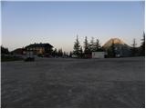
Through the Karawanks Tunnel we drive into Austria, then we continue driving on the Tauern motorway. Further, we drive through the Katschberg Tunnel and later also the Tauern Tunnel / Tauerntunnel, but we follow the motorway towards Salzburg (also Solnograd) only to the exit for Radstadt, Schladming. We continue on the road to the town of Schladming where we then continue left onto the ascending road following the signs for Ramsau. In the town of Ramsau we continue a good 2 km further on the mentioned road, then we turn right onto the toll road, where the signs for the gondola cable car direct us. We follow this road all the way to the large parking lot in front of the lower station of the gondola cable car.
Route description:
From the parking lot, we continue past the lower cable car station following the signs to Südwandhütte. The path first leads along the right side of the cable car through a sparse larch forest, later turns left and crosses the slopes to the west. Soon a path branches off to the right towards the climbing garden (Klettergarten). We continue crossing the slopes to the west and from the left the path from a lower starting point joins us. From the junction there then follows about 10 minutes of walking on a scenic slope to the Südwandhütte hut.
From the hut, we continue following the signs »Klettersteig Anna« and in a gentle descent cross the slope to the north. The path quickly brings us to a junction, where we continue left downhill, straight ahead the path leads to the climbing route Johann. From the junction, the path begins to descend somewhat more steeply past sparse dwarf pines and brings us back to a junction. This time we continue right following the signs »Klettersteig Anna«, left the path leads downhill to the alpine pastures Glösalm and Bachalm. The path soon brings us to scree slopes which we cross for some time, then a signpost directs us slightly right, straight ahead the path leads to the Adamek Hütte hut. Further on, the path is marked with red dots and after a short ascent brings us to the start of the climbing section.
The climbing path already at the start ascends almost vertically up a pillar, aided by numerous bolts (difficulty C/D). The path then becomes slightly less demanding and soon turns right where we ascend along the steel cable on a steep rocky slope. A more demanding ascent with bolt assistance follows, bringing us to the point called Mittersteinköpfl (C). The path then turns left and a short traverse to smooth slabs follows (B). The path then ascends the smooth slabs upwards (B/C) and then steeply ascends with bolt assistance (C). An ascent of a very steep gully follows (C/D). Further on, the path becomes a shade less demanding (up to B/C), but remains very exposed. In the final section, the path becomes more demanding again and ascends a vertical smooth wall with the aid of numerous bolts (D). The path then gradually becomes less demanding and an ascent along the steel cable on a less demanding ridge to the summit follows.
From the summit, we continue along the ridge and after a short descent join the direct path from the Südwandhütte hut.
The path, marked with red dots, continues crossing slopes to the west. In early summer, snowfields may still be present on this section. The path then turns right and ascends the scree to the start of the climbing path Johann Klettersteig.
The climbing path first ascends along the steel cable towards the wall (difficulty C), then a short traverse left follows, bringing us to the entry overhang, the most difficult point on the entire route (difficulty E). Bolts assist over the overhang, but considerable arm strength is still required for the ascent. From the overhang, which is not overly long, a steep ascent with bolt assistance follows (difficulty D). For a short time the path becomes a shade easier (difficulty B), then it ascends steeply again along the steel cable (difficulty C/D). Further on, the path ascends a steep slope for some time (difficulty up to B/C) and brings us to a short level section where a rest is possible.
The path becomes more demanding again and first ascends along the steel cable (C), bringing us to an even steeper section. Further on, we ascend mostly vertical wall for some time, aided by numerous bolts (C/D). Higher up at the point called Adlerhorst (2470 m), the path becomes even more exposed and ascends a vertical smooth wall (D). The vertical ascent is relatively long, but numerous bolts also assist on this section, easing the climb. The path then brings us to a somewhat wider ledge where there is a lot of loose rock, so we must take great care not to dislodge stones.
On the ledge the path turns slightly right and after a short steep ascent (C/D) brings us to the logbook box at 2500 m altitude. Further on, the path becomes somewhat less demanding and only occasionally ascends more steeply. In the final section towards the hut, the more demanding parts become increasingly frequent (difficulty up to D). Right at the end of the Johann climbing path, an exposed exit traverse follows, bringing us to the Seethalerhütte hut. At the hut, located right next to the glacier, a fine view opens to the north and the mountains above the glacier.
From the hut, we continue on a wide groomed path across the glacier, which begins to descend gently. Soon we reach a bend where the path turns right downhill. At this point we leave this path and head decisively left towards the east ridge of Hoher Dachstein summit. During the glacier ascent we will also cross a crevasse, marked by a warning sign. On this section the glacier is still relatively flat and soon we arrive below the rocky slopes of the east ridge where we leave the glacier.
To the start of the secured path we must first climb about 20 metres from the glacier up a fairly steep unsecured slope. Rope belaying is recommended on this section. The initial steep part can be avoided by continuing briefly on the glacier then sharply left up a narrow gully to the secured path. In this section the glacier is slightly steeper and we cross another small crevasse.
Once at the secured path, we continue ascending fairly steeply along the east ridge (difficulty up to B). The path then becomes a shade less steep and runs along the right side of the ridge. Later the path turns right from the ridge and after traversing a ledge joins the path running across the glacier.
At the junction we continue left and begin ascending somewhat more steeply again (B). Further on, the path ascends steeply several times with bolt and bracket assistance, then we soon reach the summit.
The described path is extremely demanding and rated difficulty level E. The path is also very long, so it is suitable only for experienced mountaineers with sufficient fitness and a lot of arm strength.
From the summit we descend the ascent path to the glacier then along the groomed path across the glacier to the upper station of the gondola cable car. Instead of the cable car, descent is also possible on foot via the Hunerscharte col (difficulty B).

Photos:
 1
1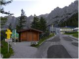 2
2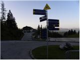 3
3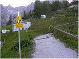 4
4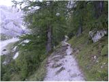 5
5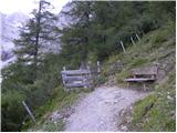 6
6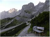 7
7 8
8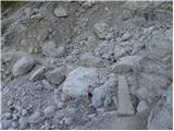 9
9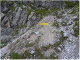 10
10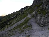 11
11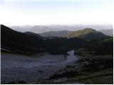 12
12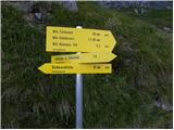 13
13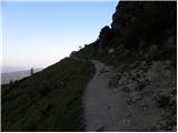 14
14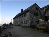 15
15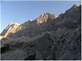 16
16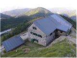 17
17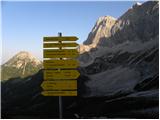 18
18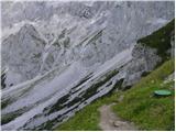 19
19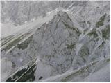 20
20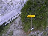 21
21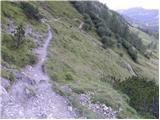 22
22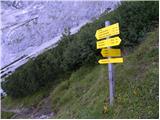 23
23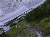 24
24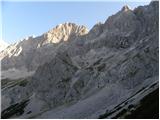 25
25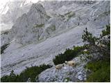 26
26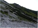 27
27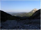 28
28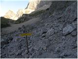 29
29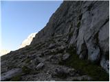 30
30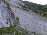 31
31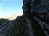 32
32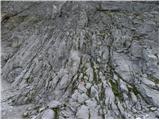 33
33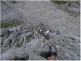 34
34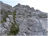 35
35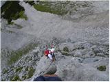 36
36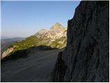 37
37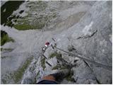 38
38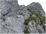 39
39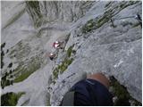 40
40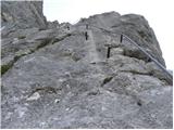 41
41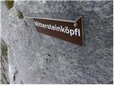 42
42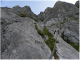 43
43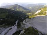 44
44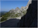 45
45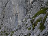 46
46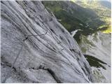 47
47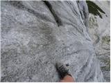 48
48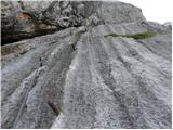 49
49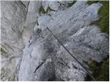 50
50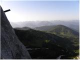 51
51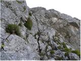 52
52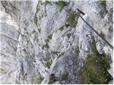 53
53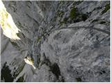 54
54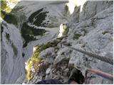 55
55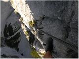 56
56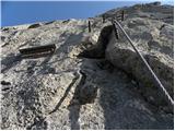 57
57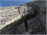 58
58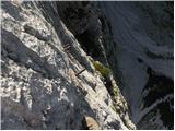 59
59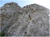 60
60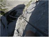 61
61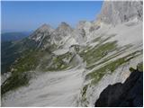 62
62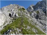 63
63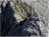 64
64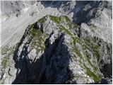 65
65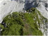 66
66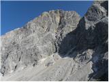 67
67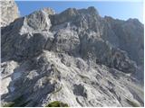 68
68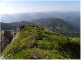 69
69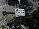 70
70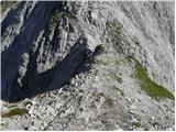 71
71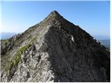 72
72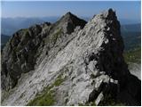 73
73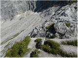 74
74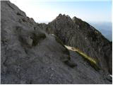 75
75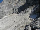 76
76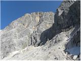 77
77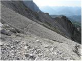 78
78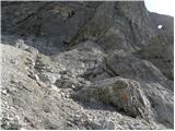 79
79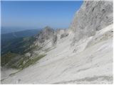 80
80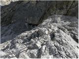 81
81 82
82 83
83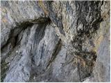 84
84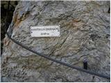 85
85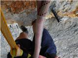 86
86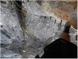 87
87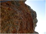 88
88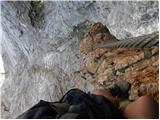 89
89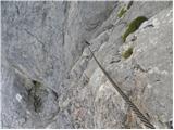 90
90 91
91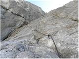 92
92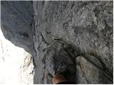 93
93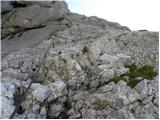 94
94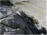 95
95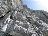 96
96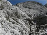 97
97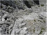 98
98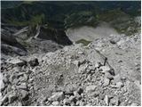 99
99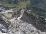 100
100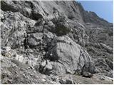 101
101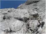 102
102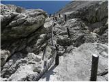 103
103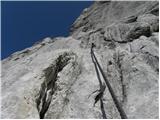 104
104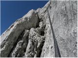 105
105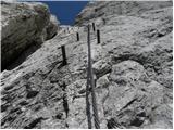 106
106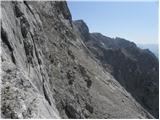 107
107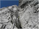 108
108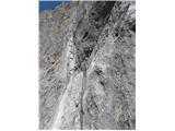 109
109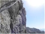 110
110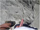 111
111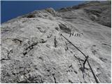 112
112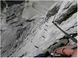 113
113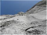 114
114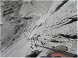 115
115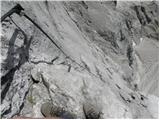 116
116 117
117 118
118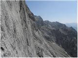 119
119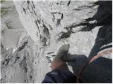 120
120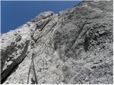 121
121 122
122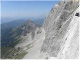 123
123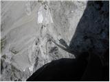 124
124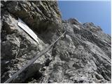 125
125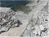 126
126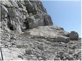 127
127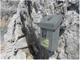 128
128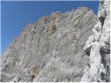 129
129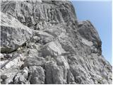 130
130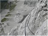 131
131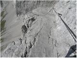 132
132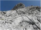 133
133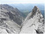 134
134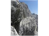 135
135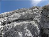 136
136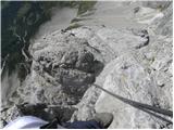 137
137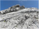 138
138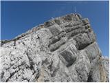 139
139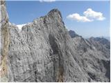 140
140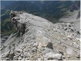 141
141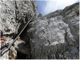 142
142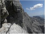 143
143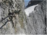 144
144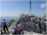 145
145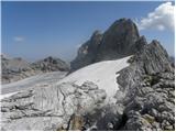 146
146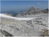 147
147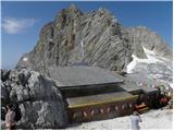 148
148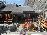 149
149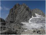 150
150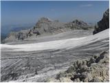 151
151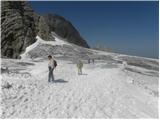 152
152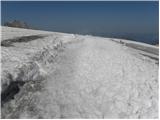 153
153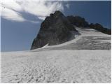 154
154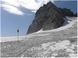 155
155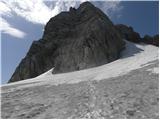 156
156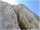 157
157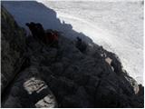 158
158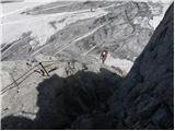 159
159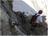 160
160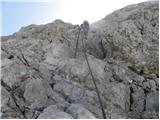 161
161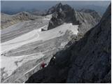 162
162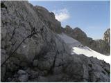 163
163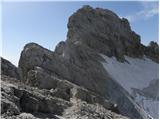 164
164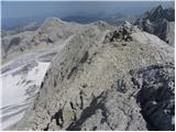 165
165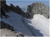 166
166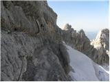 167
167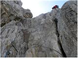 168
168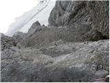 169
169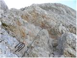 170
170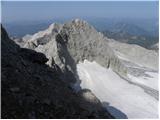 171
171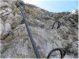 172
172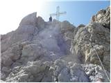 173
173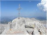 174
174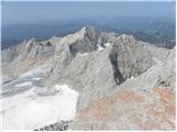 175
175 176
176
Discussion about the trip Türlwandhütte - Hoher Dachstein (Super Ferrata)
|
| Alesko197128. 09. 2011 |
Yesterday 27.9. we 4 friends climbed this thing. Thanks to the author for the exceptionally accurate description - it couldn't be better.
I'd just add that the ferrata is exceptionally physically demanding due to length, just excellent leg condition is not enough. You need to be "fit" also in arms.
|
|
|
|
| jurakjernej28. 09. 2011 |
Congratulations, looks pretty "awesome"
|
|
|
|
| urbancek28. 09. 2011 |
Congratulations, yeah, it looks pretty crazy..
|
|
|
|
| dprapr28. 09. 2011 |
Yes, Johann makes the selection right at the beginning (with the overhang)! Nice ferrata, nothing to say! Especially in connection with the summit. Although I'm not a ferrata fan!
|
|
|
|
| vanja130. 09. 2011 |
Hello!
I'm one of the 4 mentioned above, I signed up just to say that it's the mother of all vias ferratas. It blows your mind, it's that good.
|
|
|
|
| jurakjernej30. 09. 2011 |
Hello!
Where all did you gain experience before deciding on this very demanding via ferrata?
regards
|
|
|
|
| vanja130. 09. 2011 |
Now I'll give most of you a very "irresponsible" answer:
30 years I thought about climbing something like that, meanwhile visited Garadaland and some adrenaline park.
After 30 years observing mountains from afar, in 3 weeks I managed Triglav/Plemenice, Prisojnik/through the window, Mojstrovka/Hanz, Mangart/Via ferrata and Dachstein/Anna+Johan.
Here my experiences end, the other three patients have more mountaineering experience.
To get to Dachstein you don't need to be crazy but it helps.
Each to their own. I'll definitely go again this year, skip the summit and instead do the so-called Skywalk.
|
|
|
|
| Alesko19715. 10. 2011 |
Basically we constantly fly around our mountains; Kopiščarjeva on Prisank, Rekarjeva on Vrbanove špice, Hanzova on Malo Mojstrovko, Via Italiana from Belopeška etc. ... are solid preparation for the ferrata. As for Dachstein, it's much longer, more exposed and overall a step forward in that sense. Physical fitness and good equipment are a winning combination.
|
|
|
|
| vanja16. 10. 2011 |
Yesterday I fulfilled the announcement from 30.09. and reworked Anno and Johan again, but canceled the summit ascent and did the Skywalk instead.
And here the real troubles begin.
Since I couldn't find a description of this route here, here's a bit of description - more as a warning.
So access to the ferrata is from the glacier first down via ferrata rank B. The mentioned ferrata is listed on hribi.net as access to Dachstein. Midway it branches off to Skywalk.
First follows non-problematic slight crossing left along rank C cable. Then really vertical ascent rank D and later overhanging E. Pegs are like pearls, so it feels like free climbing. Since it's complete vertical, resting is only conditionally possible with via ferrata set. On the whole route there's only one spot where you can rest your butt, but you still hold on so as not to fall off the wall. No overtaking possibilities, no return path either. So I warn everyone, even those in excellent physical shape, that here 70% is arms and possible fatigue from the Dachstein ascent itself can be a big problem.
Despite only 150 height meters, ascent takes about 1h, with approach 1.5h.
Considering the above, GO FOR IT.
The ferrata is really something special, excellent views (very airy), technically very interesting as practically no pegs/brackets, but very well protected. The cable is attached every 2 meters.
|
|
|
|
| jurakjernej7. 10. 2011 |
super description, in school you'd get a straight 5 for that. 
do you have any pictures?
regards
|
|
|
|
| vanja17. 10. 2011 |
I have them, where should I put them?
|
|
|
|
| geppo7. 10. 2011 |
Open a new thread: current conditions, foreign mountains etc. - there you can upload them (can't here)
Regards
|
|
|
|
| vanja17. 10. 2011 |
Installed.
Austria, Northern Limestone Alps, Skywalk.
|
|
|
|
| CarpeDiem2478. 10. 2011 |
From these pictures one realizes why it's called Super Ferrata! 
|
|
|
|
| aonuk19. 10. 2011 |
Next year I'll try 100%, have to see this (mamo ferat)
How many km by car from Ljubljana?
best Vinko
|
|
|
|
| vanja19. 10. 2011 |
Ca. 250.
The range around Dachstein with its vertical walls is perfect for making so-called artificial ferratas.
Artificial ones are those where the goal isn't the summit but the route.
Nearby there's also the very interesting IRG ferrata, in the wall opposite Johan I saw climbers preparing terrain for a new ferrata on Dachstein in my opinion. If a drill is standard gear for today's free climbers then I'm wrong.
|
|
|
|
| mvrenc9. 10. 2011 |
Congratulations, exceptional achievement! Maybe not crazy, but brave for sure! Wonderful photos and from difficult positions, hats off!
|
|
|
|
| Kita4. 02. 2012 |
Johan and Skywalk are two of the pearls of Austrian ferratas... in that league also Kaiser Max Klettersteig E, Seewand Klettersteig E, Kupfergeist Klettersteig D/E, Königsjodler D, Sauleck Klettersteig D/E, Nasenwand Klettersteig E, Kaiser Franz Josef D, Rosslochhöhlen Klettersteig E....
|
|
|
|
| CarpeDiem2474. 02. 2012 |
Those crazy northern neighbors of ours. Something like that Ljubitelj gora, the self-proclaimed Ferrata guy, could slowly try!
|
|
|
|
| CarpeDiem2474. 02. 2012 |
Kukr, from the pictures I see, this will be a challenge tailored for you! 
|
|
|
|
| jurakjernej5. 02. 2012 |
Don't talk about pearls when you haven't been higher than Šelih's silo
|
|
|
|
| Kita6. 02. 2012 |
Yeah, you too usually start getting leg cramps when you have to climb somewhere...
|
|
|
|
| enes20. 02. 2012 |
Hello! Does anyone plan to do this via ferrata this year?
|
|
|
|
| DD20. 02. 2012 |
hi.
this year with my group I plan to do this ferrata as well as some other extreme and super ferratas in Austria and Germany and very and extremely difficult ones in Italy.
regards
|
|
|
|
| Kita20. 02. 2012 |
from this I conclude that you already have quite a few higher grade ferratas climbed? I have in plan falbach,pfaffenstain,grunstein,postalmklam,sisi klettersteig,if I manage all that it will be quite a lot....
|
|
|
|
| Poprck17. 06. 2012 |
Yesterday 16.6.2012 climbed the described combination of ferratas ending at the summit of Hoher Dachstein.
Extremely beautiful and demanding tour in a wonderful setting.
The only downside to all this adventure is the large crowd of people, both in the ferratas and on the glacier. A possible solution to avoid this is perhaps a really early start around 4 a.m., because by six it's already full everywhere. LGP U
|
|
|
|
| Poprck17. 06. 2012 |
And for those who might find it useful, current costs:
Austrian vignette 10-day 8EUR (interesting that ours is 15EUR only 7-day  ) )
Karavanke tunnel toll 13EUR (round trip), Katschberg tunnel toll 20EUR (round trip), Dachstein cable car to glacier 20 EUR (one way for adult)
the ticket is valid then at the exit also instead of road toll, if you don't buy this ticket, road toll 6.5EUR per person (for adult)
fuel about 60EUR (both ways) from Kranj area
|
|
|
|
| Poprck17. 06. 2012 |
Perhaps this too, the drive takes approx. 2.3 hours on motorways A11 and A10, exit at Eben and then via Filzmoos to the turn-off for Dachsteinbahn - valley station
At Seethalerhütte at the exit from Johann, half liter of water 0.5EUR, juice 3.5EUR
MANDATORY SUNGLASSES FOR GLACIER IN SUNNY WEATHER!!! RISK OF SNOW BLINDNESS
Equipment: Climbing harness and via ferrata set, not regular rope and carabiners http://www.youtube.com/watch?v=jOzhOs9SAws&feature=related
and mandatory one shorter sling with carabiner for resting or possibility of waiting in line
Mandatory also ice axe and crampons! - Intermediate snow fields!
And personal opinion, it says Anna is easier than Johann but I disagree, it's shorter but has fewer pegs for stepping at key points than in Johann where it's like climbing on a greased ladder, except in the entry chimney, just for information.
|
|
|
|
| Poprck17. 06. 2012 |
And when there's a queue in the wall, think that the one above you can slip and fall directly on you, which wouldn't end well for both, so it's good to have at least two pegs difference.
|
|
|
|
| sjazbec819. 08. 2012 |
It's really super! Long, exposed, well routed, well maintained. Verticals are long, boldly routed. Need considerable strength in arms and legs!! Overtaking is difficult-so you have plenty of time for panoramic pleasures. Imagine, as if you are roped up in the middle of a mighty wall.. At the top, a hut awaits. Then a walk over the glacier-and along the wall, ridge (crowded!, similar to going to Triglav) to the 2995m high Dachstein summit.
|
|
|
|
| felix6. 06. 2013 |
Is there somewhere a description of the path from the upper cable car station via the "normal" route to the summit and timetables?
Thanks and lp.
|
|
|
|
| dprapr6. 06. 2013 |
Isn't the above description from the hut onwards to the summit?
To the hut you just walk the usually trodden trail from the upper cable car station (approx. half an hour)!
Altogether approx. 1.5 hours.
Lp
|
|
|
To post a comment you must log in:
If you do not yet have a username, you must first
register.