Trate / Johannsenruhe - Hochstuhl/Stol (climbing way)
Starting point: Trate / Johannsenruhe (1152 m)
| Latitude/Longitude: | 46,4701°N 14,1562°E |
| |
Route name: climbing way
Walking time: 3 h 20 min
Difficulty: very difficult marked way
Via ferrata: B/C
Elevation gain: 1084 m
Elevation difference along the route: 1090 m
Map: Karavanke - osrednji del 1:50.000
Recommended equipment (summer): helmet, self belay set
Recommended equipment (winter): helmet, self belay set, ice axe, crampons
Views: 96.934
 | 2 people like this post |
Access to starting point:
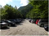
A) Through the Karawanks Tunnel, we drive to Austria, and then we drive on the highway towards Beljaku, which we leave at the first exit. From the point where we left the highway, we follow the signs for the village Šentjakob v Rožu / Sankt Jakob im Rosental. When we arrive in the mentioned village, we drive on the main road past Podgorje / Maria Elend and the settlement Sveče / Suetschach to the settlement Bistrica v Rožu / Feistritz im Rosental, where before the stores Billa and Penny we turn right in the direction of the valley Rute / Bärental. About 100 m after we leave the main road, we continue left, then on a somewhat narrower and ascending road we drive to a large parking lot (the parking lot is located near a meadow named Trate / Johannsenruhe). From the Penny store to the starting point there is approximately 9 km of narrower asphalt road, macadam only in the last part. From the entrance to the Karawanks Tunnel to the starting point there is approximately 38 km.
B) Through the Ljubelj border crossing we drive to Austria, where on the main road towards Celovec / Klagenfurt am Wörtersee we drive to the second roundabout, from where we continue driving in the direction of the exit Bistrica v Rožu / Feistritz im Rosental (we leave the main road towards Celovec before we cross the Drava River). In the mentioned settlement, immediately after the stores Billa and Penny we turn left onto the road in the direction of the valley Rute / Bärental. About 100 m after we leave the main road we continue left again, then on a somewhat narrower and ascending road we drive to a large parking lot (the parking lot is located near a meadow named Trate / Johannsenruhe). From the Penny store to the starting point there is approximately 9 km of narrower asphalt road, macadam only in the last part. From the entrance to the Ljubelj Tunnel to the starting point there is approximately 32 km.
C) From Dravograd or Slovenj Gradec we drive to Ravne na Koroškem, then we continue driving in the direction of the border crossing Holmec. When we enter Austria, we first drive towards Pliberk / Bleiburg, then we follow the signs for Globasnica / Globasnitz and further Železna Kapla / Bad Eisenkappel, Borovlje / Ferlach. Behind Borovlje at the roundabout we join the road through the Ljubelj border crossing. Here at the first roundabout we continue in the direction of Celovec / Klagenfurt, at the second in the direction of Bistrica v Rožu / Feistritz im Rosental. In the mentioned settlement, immediately after the stores Billa and Penny we turn left onto the road in the direction of the valley Rute / Bärental. About 100 m after we leave the main road we continue left again, then on a somewhat narrower and ascending road we drive to a large parking lot (the parking lot is located near a meadow named Trate / Johannsenruhe). From the Penny store to the starting point there is approximately 9 km of narrower asphalt road, macadam only in the last part. From the border crossing Holmec to the starting point there is approximately 71 km.
Route description:
From the parking lot, we continue past a gate on the road which is closed to traffic. Further on, the road becomes somewhat steeper, and we can ascend either on the road or on the footpath, which crosses the mountain road several times. Further on, the road and footpath soon bring us to a marked junction. We continue right following the signs “Hochstuhl – Klettersteig”; left leads the path to Celovška koča.
The path from the junction first begins to ascend gently over scree, then turns left and brings us to the entry into the climbing section of the path.
At the beginning of the climbing section of the path, we ascend vertically several times with the help of numerous pegs and steel cables. The path then turns left and crosses a steep rocky slope along the steel cable. There follow several more ascents along the steel cable, then the path becomes somewhat less demanding and brings us into the dwarf pines.
The path through the dwarf pines gradually becomes somewhat more demanding again, followed by several ascents along the steel cable and then a steep ascent with the help of pegs. The path then brings us through the dwarf pines to an initially indistinct ridge along which we ascend for quite some time. The ascent along the ridge runs mostly through dwarf pines; in the upper part, the ridge becomes increasingly rocky. The ridge is also somewhat exposed, and some steel cables provide assistance.
When the ridge ends, we continue slightly right, then ascend through a gully with the help of the steel cable upwards to the left. In early summer, there can still be a snow patch in the gully. From the gully, we continue right, and there follow several steep ascents along the steel cable to the logbook box beside the path. From the logbook box, a short ascent with the help of the steel cable follows, then the path becomes less steep.
Further on, the path ascends towards the main ridge of the mountain. When we reach the main ridge, we continue left and begin ascending along the Slovenian side of the ridge towards the summit, which is not far away.

Along the route: Trate / Johannsenruhe (1226m)
Photos:
 1
1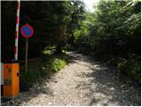 2
2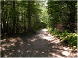 3
3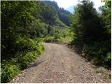 4
4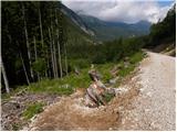 5
5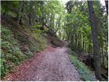 6
6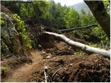 7
7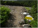 8
8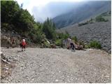 9
9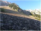 10
10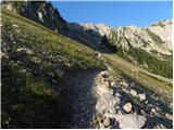 11
11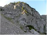 12
12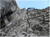 13
13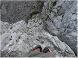 14
14 15
15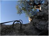 16
16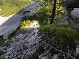 17
17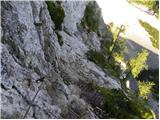 18
18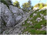 19
19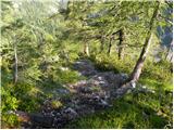 20
20 21
21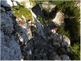 22
22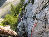 23
23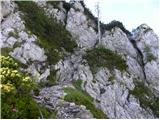 24
24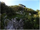 25
25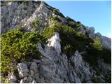 26
26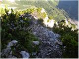 27
27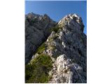 28
28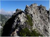 29
29 30
30 31
31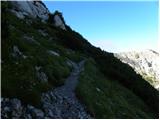 32
32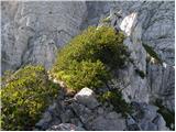 33
33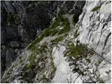 34
34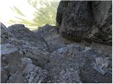 35
35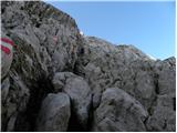 36
36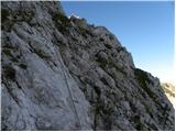 37
37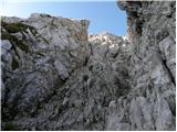 38
38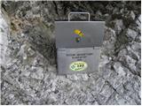 39
39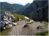 40
40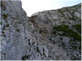 41
41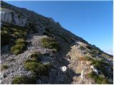 42
42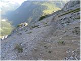 43
43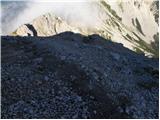 44
44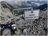 45
45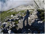 46
46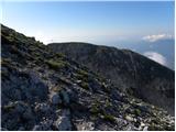 47
47 48
48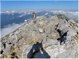 49
49
Discussion about the trip Trate / Johannsenruhe - Hochstuhl/Stol (climbing way)
Show older messages
|
| BT884. 08. 2009 |
Does anyone know the route description by car to the starting point? Probably via Ljubelj.
Thanks
|
|
|
|
| Tadej4. 08. 2009 |
Via the Ljubelj border crossing we descend to the Austrian side, then at the second roundabout (located just before the bridge over the Drava River) we take the exit for Bistrica v Rožu / Feistritz. We continue driving to the mentioned place, where the signs for Rute / Bärental direct us left onto the ascending road, which after a few km brings us to a larger parking lot where we park (further driving is prohibited).
Access to the starting point is now also described in the route description.
Best, Tadej
|
|
|
|
| BT884. 08. 2009 |
Thanks Tadej, I certainly wouldn't have found this. We'll head there, us Primorska folks to that end. Thanks again Tadej. Thanks again Tadej.
|
|
|
|
| lepenatka22. 08. 2009 |
Nice, quite secured path...and our neighbors always secure themselves with self-belay harnesses...commendable..but what if in case of crowds everything gets stuck...worth visiting, but not on weekends...
|
|
|
|
| m357522. 08. 2009 |
Can someone who has already walked the path compare the difficulty with some secured climbing path in our Alps...
|
|
|
|
| lepenatka22. 08. 2009 |
this week I did the Slovenian on Mangart and Hanzovo on V. Mojstrovka...hard to equate them...part of the path to Stol is exposed maybe like Mojstrovka, just better secured...new cables, pegs, even concrete to step easier...a bit overdone, that's why also very visited...no longer wild...in its own way still nice...worth going there if you don't mind precipices...
Safe steps I wish...
|
|
|
|
| lepenatka22. 08. 2009 |
And also this...thanks to Tadej for the precise path descriptions, as they greatly facilitate our wanderings also on less visited paths...
|
|
|
|
| m357522. 08. 2009 |
Thanks for the reply "lepenatka"
|
|
|
|
| andrejjerina22. 08. 2009 |
Lepenatka, I know you made a mistake and that's what you really meant. Hanz's path goes to M. Mojstrovka, no hard feelings. Best, Andrej
|
|
|
|
| andrej jerina30. 09. 2009 |
Today Dušan and I set off from Trate along the above-described route to the top of Veliki Stol. The path is excellently marked and secured, perhaps only the too frequent markings annoy, and they are not very aesthetic either (with clumsily sprayed dots), so all honor to our markacists for a job well done. Otherwise, in the Karavanke guidebook, the mentioned route is described as very demanding, but personally I don't find the path that demanding and in my opinion I would compare it perhaps to moderately demanding secured paths in our mountains. This is of course just my opinion, but it's worth trying. Best Andrej
|
|
|
|
| jelencek23. 10. 2009 |
What do you recommend for the first secured climbing trail with children? Thanks for the answers.
|
|
|
|
| Bojangr3. 10. 2009 |
Krainerjeva trail on Pristovski Storžič, that would be in my opinion the most suitable.
|
|
|
|
| Tadej19. 06. 2010 |
The above described path is CLOSED until further notice.
|
|
|
|
| acjom19. 07. 2010 |
Does anyone perhaps know if the path is still closed, thanks and safe in these hot days
|
|
|
|
| čebelar2. 08. 2010 |
the path is open again, we tested it and enjoyed it, because yesterday the weather was gorgeous.
|
|
|
|
| nincokl5. 08. 2010 |
I'm wondering if you have to return the same way, or if there is some circular path??
|
|
|
|
| bagi5. 08. 2010 |
Nincokl. Of course there is, since not all Austrians go to Stol via ferrata. From Veliki Stol you descend to the saddle towards Prešernova koča. There are signs pointing to Celovška koča. The path is well marked and not difficult. Slightly annoying might be the scree fields and the sun, which can heat up that area considerably.
LP Bagi
|
|
|
|
| VanSims5. 08. 2010 |
Nincokl: I went up and down the path described by Bagi. On the way back there's a slightly annoying descent on scree from the mentioned saddle then when turning towards Celovška koča after crossing a short scree field you have to climb a bit on rocks to Belščica. After crossing the border we soon descend on a nice rocky jump. What's special up to the hut is another rope, which for you, if you went up the climbing path, is just decoration! 
|
|
|
|
| nincokl6. 08. 2010 |
thanks for the reply, on Sunday I'm already on the way!!
|
|
|
|
| Klin20. 08. 2010 |
Nice hike, not particularly demanding. On the way back past Celovška koča, I also visited the nearby Kozjak, which can itself be a goal of a pleasant trip on the northern side of the Karavanke.
|
|
|
|
| Daaam13. 09. 2010 |
My opinion on the path. The first 15-20 minutes of the climbing section are quite demanding compared to the rest of the path. After that, I might really wish for a bit more challenge.
|
|
|
|
| klm13. 09. 2010 |
why didn't you then turn off the path and continue to the summit via the scree-filled and quite crumbly pathless terrain?
|
|
|
|
| klm13. 09. 2010 |
otherwise I agree with your assessment. The path is somewhat more demanding only in the lower section, then it becomes a "scenic pleasure stroll"
|
|
|
|
| lepenatka14. 09. 2010 |
To me it seems quite "overly" secured with artificial rock interventions (concrete,...), otherwise OK.
|
|
|
|
| turbo14. 09. 2010 |
"too much" protected (concrete) . . .
This spring there was a landslide on this path and it was closed for a while. That concrete, which I also don't like neither visually nor for grip, is there exclusively for safety. As it seems, there was no other way 
|
|
|
|
| acjom23. 06. 2011 |
I'm wondering if there's still any snow on this path and if Celovška koča is perhaps already open, thanks
|
|
|
|
| FLEKSARCA27. 06. 2011 |
Path dry, hut probably open. Protections on climbing section impeccable, if there was a bit more sun at the end it would be quite garish . .
|
|
|
|
| jvali30. 08. 2011 |
Can someone please tell me, if I go up this climbing route and park at the starting point as described above, can I return via another path (past Celovška koča?), and in the end reach the mentioned starting point again? Is there a junction that precisely indicates this? Thanks.
|
|
|
|
| jprim30. 08. 2011 |
Yes, of course.
From Stol descend through the scree, , which causes laborious boot cleaning.
Then to the big boulder with the sign for the Celovška koča route.
We had nice weather on Saturday, if it weren't for the strong wind.
Then just follow the markers over the saddle and you see Celovška koča.
Best regards!
|
|
|
|
| jvali31. 08. 2011 |
jprim: thanks. so, the descent path is really unpleasant? because of the scree? I'd go to Stol for the first time, do you suggest something else that's more normal-less strenuous up? hope Saturday will be suitable.
|
|
|
|
| keber131. 08. 2011 |
There is also an unmarked scree on the western side of Stol, marked with a large cairn, which significantly eases and shortens the tour, but skips Celovška koča. For more info, best to ask the warden at Prešernova koča.
|
|
|
|
| jvali9. 09. 2011 |
We haven't managed to climb Stol yet, but this Saturday will be beautiful. And this climbing route - can it be done without a via ferrata set? We've conquered quite a few of our mountains already, but without clipping in. Can it perhaps be compared to the gully on Storžič? Thanks for an honest answer.
|
|
|
|
| funnyboy9. 09. 2011 |
This path is harder than the path through Žrelo. Self-belaying is recommended, but not mandatory.
|
|
|
|
| FLEKSARCA9. 09. 2011 |
I wouldn't go without a self-belaying kit myself, but I met people without one, so it is possible to climb it. Definitely don't go without a helmet though.
|
|
|
|
| jvali9. 09. 2011 |
funnyboy and fleksarca: thanks for the reply. We never go to the high mountains without a helmet. But since my husband and I are both a bit tired, we decided to go this time on the less demanding path, namely via Žirovniška gora and Zabrški dol. More like a hike. And next time on the climbing one. I wish safe steps to all who will be on the path.
|
|
|
|
| icek8. 10. 2011 |
Does anyone have any info on Stol? Planning to head up tomorrow. Snow? How much? Thanks for info.
|
|
|
|
| heinz8. 10. 2011 |
Of course there's snow, and it can be icy too. If you mean the climbing route, wait, or with full winter gear. From this side it's not too bad, I think it'll be 10-15 cm. Quite windblown though. Expect cold etc.
|
|
|
|
| mary7. 06. 2012 |
Does anyone know the current condition of the path? Thanks, lp
|
|
|
|
| mnik18. 06. 2012 |
I was yesterday on this path and it's great. Only on one section a rock about 30-40 cm big has broken off, which is held in place only by the cable attached to it, so be careful... Regards
|
|
|
|
| folpo20. 06. 2012 |
just as a curiosity for those going from this starting point for the first time... the description may be a bit misleading for those unfamiliar with the places mentioned, as it gives the impression everything is near Ljubelj, actually it's 22 km to feistritz plus another 8 km asphalt road + 2 km gravel road (quite big potholes in some sections) to the start
|
|
|
|
| urbancek20. 06. 2012 |
@folpo: Yes, that's true, similar to say Cjajnik, which requires a bit more km driven, but it seems quite straightforward and close.
There is quite a drive in our northern neighbour yeah
|
|
|
|
| urbancek27. 07. 2012 |
Was up there today. The fixed protection is in very good, or in my opinion even exemplary condition. No issues elsewhere on the path either... Cheers!
|
|
|
|
| jprim27. 07. 2012 |
Austrians certainly take good care of their section quite exemplarily.
|
|
|
|
| Alesko197128. 07. 2012 |
A nice variant is also from Završnica valley. From the hunting huts over Zagon to the saddle between Vrtača and Celovška špica; then descend the path over scree to the Austrian side to the wall entrance, then from Stol over scree below Stol back to Završnica...
|
|
|
|
| katja871. 10. 2012 |
On Saturday, 29.9.2012, we set off on this path to Stol. Part of the climbing path is very nice, well protected, the start quite adrenaline-pumping.
We returned via the path past Celoška koča. No snow on any part of the path.
Prešernova koča on Stol was already closed, Celovška koča still open.
You can see pictures from the hike on the website of Planinsko društvo Matica Murska Sobota: http://www.mojalbum.com/pdmaticams/20120929-stol-po-plezalni/foto/20111684
|
|
|
|
| Domch17. 10. 2012 |
On Saturday 6.10.2012 I did the royal route to Stol. We started the hike in Medvedji dol and climbed via the road and scree to the entrance of the climbing wall. Use of self-protection is mandatory there, which is clearly stated and we all had it. The entry to the wall is really spectacular, well protected and adrenaline-pumping. The trail is very interesting, varied and super protected, somewhat airy in places, beautiful views of Medvedji dol, Vajnež, Svačico,... Climbing is not too difficult, but it's a long route that requires good fitness and lots of energy. At the top fog awaits us and the protective sign of Stol - wind. On the way down I met five Jesenice guys who came up for mountain bikes. Descent towards Celovška koča, but with a detour to Svačico, which has a nice view of Celovec and Vrtača. Descent to Celovška koča and to the valley. Nice tour, which personally interests me much more than the approach from Valvasorjev dom.
|
|
|
|
| Branee17. 10. 2012 |
I also went up here on Saturday 13.10 after rain, the trail itself is not difficult, concrete/iron, as much as you want.. Actually to the wall 30 min then to the top another 1:10..
@Domch that below doesn't say that you have to use SVK but talks about those SVK that were recalled because they are not safe..
|
|
|
|
| Domch17. 10. 2012 |
You really fly up there like Spider-Man.
|
|
|
|
| klemen12513. 05. 2013 |
Čeror does anyone know if the climbing path is already dry?
|
|
|
|
| jax11. 06. 2013 |
A month later, I can only repeat Klemen's question. So has anyone been up there recently?
|
|
|
|
| bojandja11. 06. 2013 |
We went on this trail with my son on Sunday, 9.6. The trail is dry, winter gear (ice axe, crampons) no longer needed. Higher up in the wall there's still one snow patch, which you can safely bypass by going around the edge, no particular danger. If you don't use a self-belay kit, as Branee mentioned, you might be at the top from the start of the route in less than an hour and a half, but with belaying it takes longer because there's quite a bit of hardware. We belayed, it took just under three hours because the kid is a bit slower at clipping ...
We descended the "normal" way, towards Zelenica and Vrtaca, then down from the saddle towards Celovska koca. Nice, short loop tour. Celovska koca is (at least on weekends) already open, food excellent but not cheap.
I recommend to all used to medium-hard vias ferratas. The trail is not too hard and not overly exposed, but for safe (and greater) enjoyment I still warmly recommend self-belaying.
|
|
|
|
| jax14. 06. 2013 |
bojan, thanks for the info.
I was up there yesterday and can only confirm the previous post. The path is dry and in good condition, on that snowfield you can squeeze by along the edge, although it's a bit awkward. But after this weather the edge will soon be big enough that it won't be a problem at all. So - if anyone wants to finally tackle a demanding rock tour, go for this one Actually, the only less pleasant feature of this tour is the descent, towards Belščica there's really a lot of scree, quite steep too, and it requires quite a bit of caution. And one more thing: the road to Medvedji dol is in pretty bad condition. You have to go slowly, but you'll get there.
|
|
|
|
| Becar1. 07. 2013 |
In the path description it would be sensible to add another half hour, due to the walk between pictures 1 and 9. Namely, 3 hours is written on the sign in picture 9, that's realistic. If you don't dash from the start like a chamois, you need at least another half hour to the fork.
|
|
|
|
| janez.novak15. 07. 2013 |
I'm interested if the path (descent from the ridge between Stol and Potoški Stol - descent approx. 400 m) on the Carinthian side through scree to the start of the climbing path is well visible - I'm thinking of going to the ridge from Valvazorja, descending down and ascending the climbing path. Similar to Via Italiani (descent from the saddle to Nogare)
|
|
|
|
| Nastasja1. 08. 2013 |
My boyfriend and I went on this path on 27.7., back past Celovška koča. On the ascent we met only two couples, at the summit there were lots of people, especially Slovenians, Austrians came back in larger numbers only around noon. Strongly recommend helmet and also via ferrata set. On the descent past Celovška koča there are several options, you can go on the marked path, or descend via scree. In both variants you need to be very careful and it's useful to have poles in the backpack. When passing the hut, you can shorten the path if you don't go on the road but cut it via a narrow path. Also at the start from the parking lot there's no need to go past the barrier; higher from the parking there's this narrow footpath that shortens the path to the climbing part considerably.
|
|
|
|
| katja874. 08. 2013 |
On Saturday, 3.8.2013, we set off along this path to the summit.
We did a circular tour: Trate/Johannsenruhe (parking) - Stol (climbing path) - Prešernova koča na Stolu - Celovška koča - parking.
We started early, so we were already at the summit before 10 a.m. The day was sunny and cloudless, so the views were magnificent. There were quite a few hikers at the summit
The climbing path is extremely beautiful and well protected. I recommend a via ferrata set primarily for safety, as the rocks are quite worn in some places
You can see photos from the hike on the website of Planinsko društvo Matica Murska Sobota: http://www.mojalbum.com/pdmaticams/20130803-stol-plezalna-pot-iz-avstrije/jutranji-pogled-na-severno-steno-stola/20971575
|
|
|
|
| zajko12. 08. 2013 |
On Sunday we (5 hikers) went up the climbing path to Stol. The path is, as others have described, well secured. But there's quite a crowd, which is somewhat annoying because hikers have different paces. From Stol we descended via the unpleasant path towards Zelenica and left to Celovška koča, and en route also to Svačica or Belščica - very interesting peak. Total hiking time 6 hours 30 minutes and total ascent 1260 m.
|
|
|
|
| jelka10029. 05. 2014 |
maybe someone knows what the conditions are like on the climbing section, I mean snowy??
|
|
|
|
| Pero#2428. 06. 2014 |
Hi,
does anyone know if this path is normally passable? How's the snow? Where do you recommend descending?
Peter
|
|
|
|
| andrejp28. 06. 2014 |
normally passable, no snow, descent towards Celovška koča...there you'll find some snow, but it's trodden
|
|
|
|
| stasoturk18. 10. 2014 |
Exceptionally beautiful marked path with well-placed protections, routed through interesting passages. The path is very well maintained. In the lower part, which is somewhat more demanding, the rock is slippery in places, caution!
|
|
|
|
| marinka6710. 04. 2015 |
We've already climbed Raduha, this path shouldn't cause us problems? Of course in "dry" conditions? We're going with kids, so we have to adapt.
|
|
|
|
| andrej7810. 04. 2015 |
Harder than Raduha... much harder...
|
|
|
|
| marinka6710. 04. 2015 |
Ugh, really? It didn't look like that from the pictures. Well, thanks, we'll plan differently then. I was thinking of going up here, then down via Celovška koča on the easier path....but up and down the same way behind. Also OK, just don't overestimate abilities.
|
|
|
|
| Branee10. 04. 2015 |
In wet it's slippery, otherwise lots of iron and concrete.. Middle grade.
|
|
|
|
| jax10. 04. 2015 |
Marinka,
I haven't been to Raduha yet, so hard to say. Regarding Stol, just this: look at pictures 13 to 16. As for the difficulty of this via ferrata, that's it, no other secrets. The start is completely vertical, but well secured. You have to get over there, then it's easier, and also very nice. In short, it's not particularly difficult, but whether it's suitable for children, of course I can't judge.
|
|
|
|
| malimiha13. 05. 2015 |
I'm interested if the path is dry. Thanks and best regards
|
|
|
|
| Edina29. 06. 2015 |
After one and a half decades I repeated this path. On the ascent nothing special, I always have concerns on steep and worn slopes where the path tilts slightly outward. On the descent into the cirque V Kožnah over scree there are at least two such sections that I would avoid if possible. Otherwise a nice and scenic tour. More on the link
http://stezeinsledi.blogspot.com/2015/06/po-lepem-pristopu-zoprn-sestop.html
Happy trails
|
|
|
|
| Majdag29. 06. 2015 |
.. Edina, I happily viewed your feat, you're great...
|
|
|
|
| janez.novak29. 06. 2015 |
Edina - as usual nice photos from a beautiful but demanding path - congratulations. By the way, what's the road to Trate like?
|
|
|
|
| zico1029. 06. 2015 |
@marinka67, maybe a bit late reply but better late than never... The path to Stol cannot be compared to the path to Raduha. Raduha is an introductory tour into the world of secured paths, while Stol is a path for those who already have some "via ferrata" experience. You don't need a via ferrata set for Raduha, but on Stol SVK is necessary to use (I went without it, but next time definitely with it).
So if you have SVK and Raduha didn't cause any problems, I suggest you go through some Storžič and then head to Stol.
I highly recommend borrowing the book 55 Secured Climbing Paths by Andrej Maser, where the paths are quite objectively described. Raduha has difficulty 2, while Stol 3 on a 6-grade scale.
Safe steps
|
|
|
|
| VanSims30. 06. 2015 |
@Edina: I didn't dislodge any rocks, did I?
@marinka67: the paths really can't be compared, Raduha is really just a secured hiking path while Stol is a real via ferrata, they are quite apart in difficulty.
I would advise visiting some other secured path here, even Storžič is much easier in my opinion, maybe also Hanzovo on Mojstrovka and perhaps something a bit harder. Maybe then Pogačnikovo on Šmarna gora, the hardest part of that path is very similar to the hardest initial part of the climbing path to Stol.
|
|
|
|
| Edina30. 06. 2015 |
@Janez the road to the parking lot is ok, further towards Celovška koča it is closed to cars.
@VanSims, you took good care of us
@Majda thanks. The trail is well secured and excellently marked and in nice weather really enjoyable
Good luck everyone on the trails
|
|
|
|
| Barentoter14. 09. 2015 |
Beautiful, secured path. Worth doing some more kilometers by car and ascending the less frequented climbing path to the top. Descent then whoo-hoo down the scree to Belščica saddle and on to Celovška koča, which is unfortunately closed for renovation.
|
|
|
|
| matz18. 07. 2016 |
Can anyone tell more precisely about the descent via scree - as I understand it branches off from the path to Celovška koča - exactly where? Is this scree suitable for descent - e.g. like from Mojstrovka? Somewhere I read that there are also cairns on the path? Where do you then rejoin the marked path? All information more than welcome
|
|
|
|
| Smetar18. 07. 2016 |
The scree is suitable for descent (if you're used to scree of course ) the path at key points is routed through scree so there shouldn't be any orientation problems. Instead of right keep a bit more "left" (parallel to the ridge)
http://hribi.net/zemljevid_poti.asp?id=53
If you look at the map, go to Vatelc 1840 and then continue to the junction below Svačica 1953 (XIV 153) towards Celovška koča (Mačenska planina). The path is trampled and also marked, at least it was...
|
|
|
|
| vetrnica19. 07. 2016 |
We walked the scree on Sunday on the way back - exactly as Smetar described. The path is nicely marked and traceable, so no problems.
|
|
|
|
| chichi3. 05. 2017 |
Hello, question for those familiar with this path. Is it possible to bypass the initial, entry part of the climbing path (first set of pegs)? We want to complete the path with children - last year we already tried, but were only partially successful. The children are not beginners on very demanding secured paths (Storžič through Žrelo, Turski žleb and Skuta, Triglav via Tominškova, Jalovec, Prisojnik via Jubilejna), however, the slightly overhanging start caused a problem and consequently they don't want to tackle that section at all. Since the path is very nice and the continuation doesn't reach the difficulty of the initial part, it would be great to do it as a whole family. Any advice welcome. Thank you.
|
|
|
|
| maregol5. 05. 2017 |
If the child just doesn't want or can't get over it, there's probably a reason for that, right?
You can tie the child and yourself to each end of the rope, climb over, set up a belay on AUTO-BLOCK on Reverso and pull the child over... I don't know if it makes sense.... good luck!
|
|
|
|
| chichi5. 05. 2017 |
Thanks for all the responses.
We certainly won't belay and pull the child over the rocky sections - there are plenty of routes to Stol, including from Celovška koča. Actually, the child himself doesn't know why this first part caused so much uncertainty and fear, when e.g. Furlanova to Gradiška Tura, Pogačnikova to Šmarna gora, the climbing route to Boč, Koroška Rinka from Okrešlj, or the ascent towards Zadnje okno on Prisank were no problem.
I asked the question because of the route description in the Karavanke guide by Klemen Janša. It states that the initial section was only built later, around 2000, and that the old climbing route ran further left from the entry part and avoided this most difficult section. So, if anyone knows more about this - we have quite some time until July.
Have a nice day.
|
|
|
|
| ben5. 05. 2017 |
Yes, I have the guide "50 Secured Climbing Routes" from 2000 at home. The initial section you mention isn't there. The route initially zigzagged across the scree field and joined the current route higher up. A couple of years ago, you could still trace that zigzag, but in recent years probably no one goes there anymore, so even if you try this bypass, it might be troublesome. With a bit of logic, you can see the junction of the old route from the climbing path.
|
|
|
|
| jprim5. 05. 2017 |
Well, let me add my opinion. A few years ago we did
this route. If I hadn't had self-belaying, I would have stopped at the beginning, as there's an overhanging section, later I didn't use the belays anymore, but the most annoying part for me was higher up where the secured section ends, as it's full of loose rocks on the path.
Otherwise, the route is under Austrian domain and helmet and self-belaying are required on the path.
Best regards!
|
|
|
|
| turbo5. 05. 2017 |
A few years ago there was a major landslide, so they had to relocate the secured path lower down. The old one had an easier entry, which no longer exists because it collapsed:
http://ktnv1.orf.at/stories/450384
It's quite possible that a year or two later, a spot that once scared you stiff, you can manage easily... in between you gain experience, grow up... try again later, maybe it'll go smoothly, if not, nicely to Celovška koča and around there are as many peaks as your heart desires :-) Good luck!
|
|
|
|
| Branee6. 05. 2017 |
asks, give him an unambiguous answer and he still seeks something..
|
|
|
|
| Becar6. 05. 2017 |
For me it's one of the best paths I've hiked, excellently secured, just enough adrenaline, just my taste. Recommend via ferrata kit. And helmet of course. If the child doesn't want to go, let him when grown up if he still wants. I don't know why I feel that he's banging his head against the wall here.
|
|
|
|
| Janezs7. 05. 2017 |
Turn it upside down, go from top down, then peace. Best.
|
|
|
|
| chichi7. 05. 2017 |
I didn't intend to speak up again, but to conclude. Branee, sorry, the one-word answer didn't convince me; with extra explanations I cleared it up. And no, no head through wall - don't know why that conclusion. I've been hiking in the mountains for over 30 years, and especially on family trips we always adapt decisions and paths to conditions and physical and mental fitness.
Thanks for all answers, especially the positive ones. Best wishes to all.
|
|
|
|
| ravats6. 06. 2017 |
Hello.
Is there still any snow on this path?
|
|
|
|
| ivoma17. 06. 2017 |
no snow left at all, I walked the path today
|
|
|
|
| jprim17. 06. 2017 |
You just didn't walk it.
Regards!
|
|
|
|
| ivoma18. 06. 2017 |
correction,
actually I didn't walk it but climbed it
|
|
|
|
| btrabe11. 06. 2018 |
Hello!
Has anyone been on the secured climbing trail to Stol these days? Is there still any snow on the path and what is the condition of the fixed protections? Thanks for the reply...We would like to go to Stol via this path on Saturday, 16. 6....
|
|
|
|
| TamaraTP15. 06. 2018 |
btrabe, hello!
The path is normally passable, no snow, the fixed protection is in good condition, except for one, which doesn't pose any threat or problems. Prešernova koča on Stol is open. If you return from Stol via Belščiica saddle - there's some snow there, but it can be avoided and continue to Celovška koča and then all the way to the start. All without problems. It's a nice hike.
Safe steps!
|
|
|
|
| btrabe15. 06. 2018 |
Tamara TP, many thanks, and best regards!
|
|
|
|
| CarpeDiem24730. 06. 2018 |
Today with a colleague we conquered this summit via the indicated path and descent via the easier one past Celovška koča. Excellent hike and no snow anywhere on the path, despite the cooling and snowfall a few days ago.
However, we were not impressed by the attitude of the staff at Prešernova koča. Quite different from Celovška koča
|
|
|
|
| VanSims30. 07. 2018 |
Regarding the debate on descending this via ferrata: why not just down the via ferrata for those with plenty of experience and mileage? It's not difficult, except in the lower, initial part where it gets a bit airy. For that part on descent, maybe recommend gloves.
As for the concrete in the initial part, like some above, I don't like it either. But then the lower sections wouldn't be B, B/C but C, C/D. Descent down then really only for the seasoned.
|
|
|
|
| masker21. 08. 2018 |
On Sunday, 19.8.2018, my brother and I conquered this beautiful Karawanks peak from the Austrian side for the second time. I somewhat forgot about the initial steep and bold entry into the via ferrata, which later "settles down" a bit. But only for a short time. Later, you need some strength in your arms again to cope with the interesting rock climbing. Really excellent tour (medium difficult). More than five years ago, it didn't seem so demanding to me. Now, however........that's how it is. Good luck to all mountain lovers!!!
|
|
|
|
| masker21. 08. 2018 |
And also this. In Prešeren hut they welcomed us very nicely. Excellent jota. Also in Klagenfurt hut the "Austrian beer" with sweet addition - apple strudel of course tasted great.
|
|
|
|
| skavt15. 10. 2018 |
Hello, yesterday, on Sunday, I climbed my first via ferrata, namely to Cjajnik (last part via the easier, right cable), then continued the path to Kosutnikov turn and descended via the easier ferrata over the bridge and scree to Kosutina koča. I'm wondering if the difficulty of the ascent to Stol is comparable to the ascent to Cjajnik?
|
|
|
|
| jax15. 10. 2018 |
Stol is easier. Much easier.
|
|
|
|
| ms_primoz15. 10. 2018 |
No comparison at all with Stol, Cjajnik is so much more demanding...
|
|
|
|
| Domch15. 10. 2018 |
Technically, Cjajnik is incomparably harder, but via the secured path to Stol you climb to a higher altitude.
|
|
|
|
| skavt15. 10. 2018 |
Thanks a lot for the answers already looking forward to the ascent
|
|
|
|
| jvali3. 07. 2019 |
Hello. If I ascend Stol via this path, which way back to the starting point? Thanks for the reply. Valerija
|
|
|
|
| azzey3. 06. 2020 |
Has anyone gone along the mentioned path? Is there any snow?
|
|
|
|
| Kvis3. 06. 2020 |
Climbing route dry about a week ago. On descent back towards Celovška koča, short snowy section, crampons needed only if snow is icy (rain+cold day before).
|
|
|
|
| Hribovc9128. 06. 2020 |
In the upper section at one spot the cable is missing. Caution required there, otherwise the path is very well secured.
|
|
|
|
| fjr6. 07. 2020 |
Yesterday 5. 7. 2020 I did this path. The path is very nice, really well secured. I would just warn that somewhere in the middle of the path, a section of the path has been washed away. Extra caution is needed there.
|
|
|
|
| Alenka.12328. 10. 2020 |
Hello, if anyone is interested, you can join me for this hike next year 2021. I need company so I don't go alone. Regards Alenka
|
|
|
|
| Enka22. 07. 2023 18:55:08 |
Has anyone gone on this trail in recent years? How up-to-date are the reports about the missing cable and the washed-out section of the path?
|
|
|
|
| LISAC23. 07. 2023 19:01:49 |
One doesn't help much but still; I went there long ago in August 2019 and back then the entire path was without any issues regarding damage. But I don't know how it is now...
|
|
|
|
| Enka23. 07. 2023 21:03:53 |
Yeah, even further back in 2017 I went too and everything was bp, but these damage reports are from 2020
|
|
|
|
| rinča23. 07. 2023 22:18:54 |
I went on it last year. The path was without peculiarities, the belays in good condition.
|
|
|
|
| rensul24. 07. 2023 20:52:22 |
I was there on 15.7.2023. The entire path is without any special features.
|
|
|
|
| Enka24. 07. 2023 21:37:57 |
Thanks everyone for the information!
|
|
|
|
| Elija21. 10. 2024 13:12:15 |
On 20.10.2024 we wanted to ascend this path and it is closed. It is indicated on all signs. A hiker from Austria told us that a rockfall supposedly damaged the path.
Notice
|
|
|
|
| Goli2516. 08. 2025 19:40:16 |
Hello, I'm wondering if the path is open or not, lp thanks for the info
|
|
|
|
| turbo16. 08. 2025 20:07:50 |
I was there on 14.6. and the path was without any special features.
https://photos.app.goo.gl/x1Kcc17JWHPTYXHPA
The road to the last parking lot at Trate was quite damaged, but I had no problems (SUV 4x4), though the hut keeper warned me about it when I checked myself if the climbing path was open. The season is at its peak, I hope they fixed it.
If there's ever anything special on the paths, they usually post it on the hut's website:
https://www.klagenfurter-huette.at/
|
|
|
To post a comment you must log in:
If you do not yet have a username, you must first
register.