Dolina Krma - Vodnikov dom
Starting point: Dolina Krma (944 m)
| Latitude/Longitude: | 46,3851°N 13,9071°E |
| |
Walking time: 3 h 30 min
Difficulty: easy marked way
Elevation gain: 873 m
Elevation difference along the route: 1050 m
Map: Triglav 1:25.000
Recommended equipment (summer): helmet
Recommended equipment (winter): helmet, ice axe, crampons
Views: 29.763
 | 2 people like this post |
Access to starting point:
a) We exit the Gorenjska motorway at the Hrušica exit and continue following the road in the direction of Kranjska Gora. Just a little before the village of Dovje, the road leading to Mojstrana (Vrata, Kot and Krma) branches off to the left from the main road. We continue along the road in the direction of the village of Radovna and the Krma and Kot valleys. The relatively steep road then leads us past the TNP sign, after which the road soon flattens and brings us to an intersection, where a gravel road branches off to the right into the Kot valley. We continue straight ahead on the road that begins to descend. In the middle of the descent, a road branches off to the right into the Krma valley (straight ahead to Radovna). A little further on we reach the next intersection, where we continue right in the direction of Krma. The gravel road then brings us to Kovinarska koča, and we follow it further. The occasionally somewhat poorer road then brings us to the parking lot in front of the barrier.
b) We drive to Kranjska Gora, then continue driving in the direction of Jesenice. At Dovje we leave the main road and continue right in the direction of Mojstrana and the valleys of Vrata, Kot and Krma, following the signs for Krma at the following intersections. The relatively steep road then leads us past the TNP sign, after which the road soon flattens and brings us to an intersection, where a gravel road branches off to the right into the Kot valley. We continue straight ahead on the road that begins to descend. In the middle of the descent, a road branches off to the right into the Krma valley (straight ahead to Radovna). A little further on we reach the next intersection, where we continue right in the direction of Krma. The gravel road then brings us to Kovinarska koča, and we follow it further. The occasionally somewhat poorer road then brings us to the parking lot in front of the barrier.
Route description:
From the last parking lot in the Krma valley, named Pri lesi, we continue along the poorer road that continues through the valley and soon brings us to a clearing, where we bypass the nearby building on the left side. We continue along the gravelly path, which approaches the torrent and a little further crosses it as well. On the other side of the torrent the path enters the forest and initially still gently, then for some time quite steeply ascends. Higher up we exit the forest into a belt of dwarf pine and shrubs, and from the path beautiful views open up to the nearby rock walls of the peaks, which on the other side slope more gently towards Pokljuka.
Higher up, somewhere at an altitude of a little more than 1400 m the path temporarily levels out and brings us to the beautiful grassy plain Vrtača.
After the grassy part the path begins to ascend again along a path that is often quite slippery in this part, which levels out on the Malo polje plain.
Here the path turns right and branches.
We continue left in the direction of Vodnikov dom na Velem polju (straight Planika and Kredarica) along the path that quickly begins to ascend first through the larch forest, then up the scree slope. The path on the scree becomes increasingly steeper and is dangerous for slipping in snow, which can remain here until mid-summer. Higher up we ascend transversely to the left below the walls of Vernar and due to the narrowness of the last part of the path to Bohinjska vratca there is also an increased danger of falling rocks. Below the vratca the path turns slightly to the right and steeply ascends to Bohinjska vratca, from where a nice view opens up.
At Bohinjska vratca an unmarked path branches off to the right to Vernar (higher up the path turns into very demanding off-trail terrain), we begin to descend towards Vodnikov dom, which we reach after approximately 15 minutes of descent.
Krma - Malo Polje 2:05, Malo Polje - Bohinjska vratca 1:10, Bohinjska vratca - Vodnikov dom 0:15.

Along the route: Vrtača (1430m), Malo polje (1585m), Bohinjska vratca (1975m)
The trip can be extended to the following destinations: Cesar,
Koča na Doliču (2 h),
Vernar,
Dom Valentina Staniča,
Vrh Snežne konte,
Šmarjetna glava (2 h 40 min),
Dom Planika,
Visoka Vrbanova špica,
Begunjski vrh,
Triglavski dom na Kredarici,
Rjavina,
Triglav
Photos:
 1
1 2
2 3
3 4
4 5
5 6
6 7
7 8
8 9
9 10
10 11
11 12
12 13
13 14
14 15
15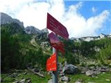 16
16 17
17 18
18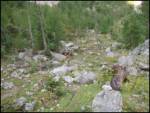 19
19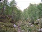 20
20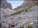 21
21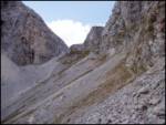 22
22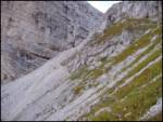 23
23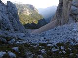 24
24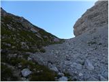 25
25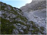 26
26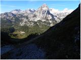 27
27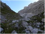 28
28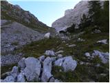 29
29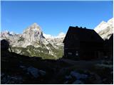 30
30
Discussion about the trip Dolina Krma - Vodnikov dom
|
| HOPLA6914. 08. 2009 |
The Krma - Vodnikov dom trail walked a few days ago is decently marked and without special features.
|
|
|
|
| Aleksander55513. 07. 2023 19:46:15 |
On Tuesday 11.7.23 we intended to reach Vodnikov dom from the Krma valley. We didn't manage to reach the hut because there is no sign for the turn-off towards the hut and we simply continued towards Zgornja Krma. Does anyone know the conditions or the problem with this path? LP
|
|
|
|
| rensul13. 07. 2023 22:00:44 |
Aleksander555-The junction is at Mali Polje, at 1550m altitude. Along the path towards Zgornja Krma there is a marking on a large stone with arrows left and right. If you look about 30 m directly across this stone, you will notice a rock with a vertical crack containing an iron bar (pole). To the left past this rock you will notice a poorly visible path. I'm sending you a link and picture with the marking too. https://www.strava.com/activities/7297861211
|
|
|
|
| turbo14. 07. 2023 18:42:14 |
End of July 2021, two years ago therefore, I myself barely found the junction to Vodnik. If I hadn't been here before and been quite familiar, I would have gone ahead, i.e. wrong. After the tour I sent a warning to PZS, the trails commission, with a detailed description of the problem. No response, last year it was the same, I see it's not much different this year either 
|
|
|
|
| cofka14. 07. 2023 18:51:55 |
Obviously PZS has become something else than what the acronym stands for.
|
|
|
|
| turbo14. 07. 2023 19:33:00 |
|
|
|
|
| di8. 09. 2024 09:54:12 |
Still (unfortunately):
The sign for the fork (picture 16) can no longer be found.
Also some path (where it should lead) is not visible (it's somehow like in picture 18).
|
|
|
|
| turbo8. 09. 2024 10:07:49 |
SHAME on PZS, go to hell I won't say what, four years (2021, 2022, 2023, 2024) and zero point zero from you. It seemed to me that it would be like this, since I didn't get any response from you to my email, and now in the last two years I've read several times that the junction is still not marked. It's a very crowded Krma valley and a quite visited Vodnikov dom hut, I wouldn't say if it were a section of the trail somewhere above Bavšica or something similar, for those ends you might not even know they exist 
|
|
|
|
| serajko8. 09. 2024 13:08:13 |
Turbo, it's possible that the path will be abandoned due to lower costs. One should find the maintainer and ask about its "health". It seems to me that the path is not particularly crowded, as there are no more signs of use visible in nature. If it's no longer marked, it will be pathless!
|
|
|
|
| turbo8. 09. 2024 13:20:39 |
On the PZS website, in the "Hiking Trails" section, the Zgornja Krma-Bohinjska vratca trail is entered, marked and rated as easy. Suitable for a family outing, say. Well, it would be suitable if the junctions and other paths were correctly marked 
https://mapzs.pzs.si/path/31602
|
|
|
|
| bbugari18. 09. 2024 13:42:45 |
Unfortunately, this is also true for some sections of the SPP, such as Tolstovršnik-Savinja, Dobrča-Prevala, Rožca-Hruški vrh-Dovška Rožca, source of Soča-Na Logu, etc. 
|
|
|
|
| Tadej23. 02. 2026 11:29:44 |
|
|
|
To post a comment you must log in:
If you do not yet have a username, you must first
register.