Poldov rovt (Vrata) - Dovški križ (via bivouac)
Starting point: Poldov rovt (Vrata) (941 m)
| Latitude/Longitude: | 46,4216°N 13,86289°E |
| |
Route name: via bivouac
Walking time: 5 h 30 min
Difficulty: very difficult unmarked way
Elevation gain: 1601 m
Elevation difference along the route: 1601 m
Map: Triglav 1 : 25.000
Recommended equipment (summer): helmet
Recommended equipment (winter): helmet, ice axe, crampons
Views: 38.951
 | 4 people like this post |
Access to starting point:
We drive to Mojstrana, then follow the signs for the Vrata Valley. We continue through the Vrata Valley, about 100 meters before the 10 km road sign, and notice a cart track that branches off to the right perpendicularly to the main road. Here is the beginning of the described path. The marked parking lot where parking is allowed is located approximately 500 meters further along the main road.
Route description:
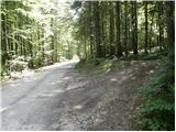
We head onto the cart track that leads into the forest and then past a smaller house, where we continue slightly to the left onto a footpath. Through the forest, we ascend slightly to the left towards Rdeči potok. A little before the stream, the path over Brinje branches off to the right (cairn placed, and on the tree is carved some kind of face and letter L). The path then brings us to the stream bed. Here the path goes along the right side (left bank) upwards and then soon crosses the stream to the left side. The path ascends through a small valley until a smaller wall blocks the path, where we usually also encounter a spring. From here, the path goes right and steeply ascends through a natural passage. Slightly exposed and unsecured. We are above a small waterfall (if there is water). Here we emerge from the forest and ascend over some scree fields. The path over the scree is not comfortable as storms and avalanches destroy it every year. The path soon turns slightly to the right and ascends for a short time on a grassy slope. Then follows another ascent beside scree fields and soon we reach the bivouac at Jezerih, which we will notice on our left. Here we can overnight or just shelter in case of a thunderstorm. Here the terrain flattens. The view of Triglav is very nice from here.
The path from the bivouac onwards gradually disappears but we can still follow it. We continue slightly to the right towards the saddle between Dovški Križ and Šplevta. At the saddle, we head left onto the scree, from which after a short ascent we head right and cross a steep rocky slope. When we reach grassy slopes, we head left upwards. On this section of the path, we will notice several poorly trodden tracks, all marked with cairns. When dry, it is best to choose the rightmost one, which ascends on a grassy slope. At the end of the track, it turns left towards the gully. We ascend through a short not overly steep gully, then at the end of the gully turn sharply right. If we continued straight at the end of the gully, we would reach only the forepeak of Dovški Križ. When we turn sharply right, the track brings us to the steep eastern slopes of the forepeak. We cross the slopes towards the north and the most demanding section follows. We descend a steep slope into a narrow notch. The descent is very short, but caution is required because there is usually quite a lot of sand on the rocks. From the notch, we then ascend to the other side, then the cairn directs us left onto the ridge. A better-trodden track goes straight here, but if we want to avoid scree in the last part of the path, it is better to ascend to the ridge already here. Walking along the ridge is then no longer difficult and we soon reach the very panoramic summit.
The ascent to Dovški Križ is suitable for mountaineers for whom climbing 1st degree causes no problems.
Despite the fact that a track (often poorly visible) leads to the summit, orientation remains difficult.

Photos:
 1
1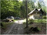 2
2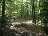 3
3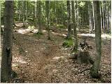 4
4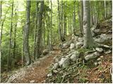 5
5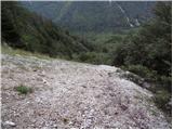 6
6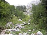 7
7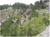 8
8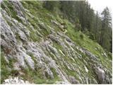 9
9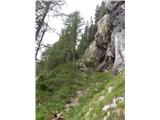 10
10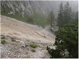 11
11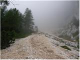 12
12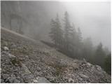 13
13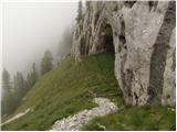 14
14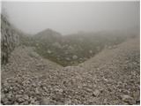 15
15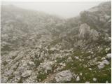 16
16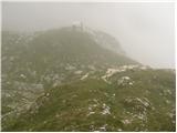 17
17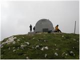 18
18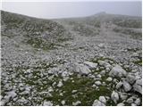 19
19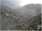 20
20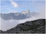 21
21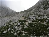 22
22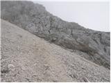 23
23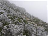 24
24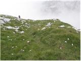 25
25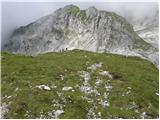 26
26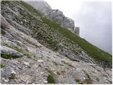 27
27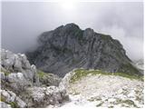 28
28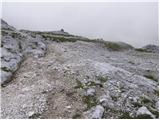 29
29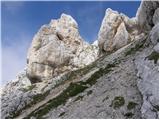 30
30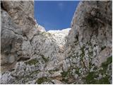 31
31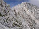 32
32 33
33 34
34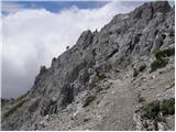 35
35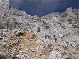 36
36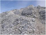 37
37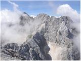 38
38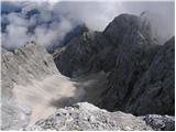 39
39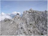 40
40
Discussion about the trip Poldov rovt (Vrata) - Dovški križ (via bivouac)
|
| ljubitelj gora23. 04. 2012 |
Approximately when will this trail be dry? Would anyone go?
|
|
|
|
| turbo24. 04. 2012 |
The trail is dry exactly from when the last patches of snow melt. I'd go, I'd go. Many would go.
|
|
|
|
| ljubitelj gora4. 10. 2013 |
Picture 11: I walked there last year and yesterday, this visible path across the scree, but where does it end (last year we went and turned back), later I found out that the descent via the gully should be harder, at least that outlet was visibly harder. Namely, you still need to descend along the scree or among the bushes on the right side (visible path). Lower above the waterfall (careful, as it's airy below) cross the scree and take the visible path on the left and continue along. Picture 26 no need to go through the gully, because the path goes uphill on grass and joins picture 30. And I don't know why this path is described as: very demanding unmarked path, because it's not entirely. Writers from Google mention pathless terrain and descent into the notch rated UIAA I, that descent is short with steps, there are plenty of holds but what good when everything crumbles. And one well-meaning tip: this path is absolutely suitable only for descent and not for ascent. Now what is the opinion of others who have done it once or multiple times, it would be good to hear. It depends from winter to winter, nature's force. I'm also adding picture 26, if someone is above you be careful not to trigger a rock on you.
|
|
|
|
| JusAvgustin4. 10. 2013 |
The path along Rdeči potok to bivak II. at Jezera is perfectly fine also uphill, since you don't walk constantly on scree, but along its left edge-viewed uphill towards Jezera. The path crosses scree only a few times, the rest runs on a nice trail. The fact is that the ascent to DK belongs to pathless approaches with some climbing sections UIAA I. That notch before the summit rocks can be quite annoying-especially in winter, so I left an auxiliary rope around the rocks there for possible abseil. The rest on DK is walking and next to Kukova špica it is one of the easiest approaches in Martuljek. Of course on the normal route!
|
|
|
|
| pohodnik386. 10. 2013 |
Nice, just a bit too fast... Once slower and it will be good, I prefer videos because they somehow show more than just photos
Best regards! Tone
|
|
|
|
| Macesna9. 10. 2013 |
I agree with Juš regarding the path to bivouac II. It's a perfectly fine path, it goes quite to the left (facing uphill), and the view that opens up from here to the bivouac and to the Rokavi is incredibly beautiful, almost thrilling. There's very little scree, and in the upper part mostly on pleasant grass. Descent is via scree right on the right side (facing uphill) and only in the forest you join the known trail you took up.
|
|
|
|
| JusAvgustin9. 10. 2013 |
The Rokav symphony is simply impressive 
|
|
|
|
| Macesna9. 10. 2013 |
I hope to hear some chord soon ...
|
|
|
|
| JusAvgustin12. 10. 2013 |
I'd love to experience that!  you won't even find it on Pelce! you won't even find it on Pelce!
|
|
|
|
| di17. 10. 2014 |
I'm interested in the optimal approach to the slope itself for Dovški križ, i.e. where to cross the steep rocky slope: at the lowest point, somewhere in the middle…
Attaching (poor quality) photo:
http://www.hribi.net/profil.asp?id=11979
|
|
|
|
| ljubitelj gora12. 09. 2021 23:49:24 |
There are some new paths down there so no need to struggle too much on the scree.
|
|
|
|
| Jernej96818. 07. 2024 15:57:53 |
Last weekend I climbed to DK via this path. I also expected more trouble with scree fields on the ascent, but as Juš writes, the path only briefly crosses scree in a few places. To the left of the largest scree field below Mala Šplevta there is a very nicely passable grassy terrain. Just below the bivouac, I even treated myself to a bit of easy climbing on steep grass and thus stepped right in front of the bivouac door. For the descent, it's a completely different story. If I add up all the scree fields I descended from the bivouac to the valley, even deep in the forest, they amount to 550 meters of elevation - which is practically half the descent from the bivouac to the asphalt.
|
|
|
|
| renko28. 04. 2025 15:10:02 |
|
|
|
To post a comment you must log in:
If you do not yet have a username, you must first
register.