NC Planica - Slemenova špica (via Črne vode)
Starting point: NC Planica (931 m)
| Latitude/Longitude: | 46,476°N 13,7241°E |
| |
Route name: via Črne vode
Walking time: 2 h 55 min
Difficulty: difficult marked way
Elevation gain: 980 m
Elevation difference along the route: 990 m
Map: Kranjska Gora 1:30.000
Recommended equipment (summer): helmet
Recommended equipment (winter): helmet, ice axe, crampons
Views: 118.248
 | 6 people like this post |
Access to starting point:
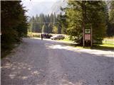
From Kranjska Gora we drive towards the Rateče border crossing, but only to the place where (at the village of Rateče) the road to Planica and the Tamar valley branches off to the left. The road, which ascends moderately, soon takes us to a large parking lot at the ski jumps in Planica. From here we continue along the gravel road in the direction of the Dom v Tamarju, which we then follow to the parking lot located near the mountain hut.
Recently the road to the Tamar valley is closed. This lengthens our path by approximately 1 hour.
Route description:
From Planica we continue along the gravel road towards the Dom v Tamarju, before the road enters the forest it splits into two parts. We continue along the slightly right road in the direction of the footpath towards Tamar (slightly left is the drivable road, which is closed to public traffic).
The path ahead leads us along the road which after passing the last parking lot of NC Planica enters the forest and which in winter is converted into a cross-country ski trail. This is followed by an ascent along a gentle road that mostly runs through the forest. When the path leaves the forest there are signposts along the path with inscriptions of what can be seen. Higher up the forest thins out several times or we leave it for a while so that beautiful views open up of the mountains rising above Planica and Tamar. When we are already quite close to the Dom v Tamarju a wonderful view of Jalovec opens up and the path branches.
We continue slightly left (slightly right to the source of the Nadiža) and a few minutes later join the drivable road along which passing the chapel we arrive at the Planinski dom v Tamarju.
Behind the hut we come to a junction where we turn left onto the cart track in the direction of Slemenova špica and Črne vode (slightly right Jalovec and Ponce). The wide path initially ascends only slightly and after a good ten minutes of walking brings us to the gravel beds of Črne vode. The marked path continues along the left side of the torrent deposits to an unmarked junction where we continue straight towards the gully we see in front of us (left to the Črne vode waterfall, 2 minutes).
The path then enters the gully where it is less visible. On both sides of the torrent there is a poorer path but only the left one is marked. This section is particularly exposed to falling rocks especially in springtime. After a few minutes walking through the gully a nice passage opens up to the left upwards through which the mountain path also runs. The path then enters the forest for a while where it ascends to slopes overgrown with sparse larch forest. The path ahead ascends along gentle scree and partly gravel which a little higher brings us to a small spring (Lovski studenec) where water is flowing. This is followed by a few minutes of steep ascent to the place where we step onto the Slatnica saddle.
Here we continue left (straight to Vršič) along the path that brings us in a few minutes to the characteristic lakes on Sleme. This is followed by only a moderate ascent along the summit slope to the top of Slemenova špica which we reach in a few minutes of further walking.
Planica - Dom v Tamarju 0:45, Dom v Tamarju - Slatnica 1:55, Slatnica - Slemenova špica 0:15.

Along the route: Dom v Tamarju (1108m), Odcep PP (1136m), Črne vode (1280m), Lovski studenec (1687m), Slatnica (1814m), Jezerca na Slemenu (1855m)
Photos:
 1
1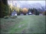 2
2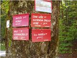 3
3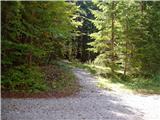 4
4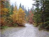 5
5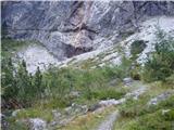 6
6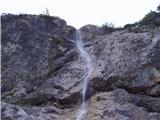 7
7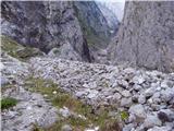 8
8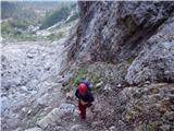 9
9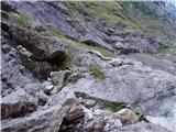 10
10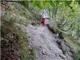 11
11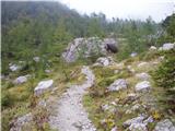 12
12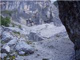 13
13 14
14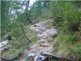 15
15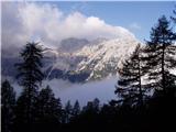 16
16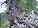 17
17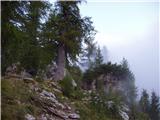 18
18 19
19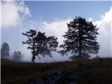 20
20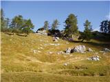 21
21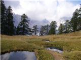 22
22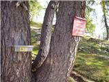 23
23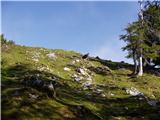 24
24 25
25 26
26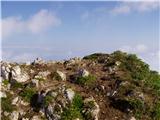 27
27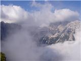 28
28
Discussion about the trip NC Planica - Slemenova špica (via Črne vode)
|
| kr neki20. 05. 2011 |
Conditions? Snow? 
|
|
|
|
| Enka28. 08. 2012 |
This is just my opinion. The path past Črnih vod along the gully (I didn't go further from the gully today) isn't really demanding, but it's not entirely easy either. The rocks are wet (even though it's peak drought now) and quite wobbly, at least some. In short, you need to be careful not to roll somewhere. It wouldn't be fatal since it's not exposed, but you can easily break something. If I compare the path to the one on Okrešelj (which is marked here as a demanding marked path!) I have to say I'd take a small child or complete beginner to Okrešelj first rather than here. Even my dog (medium size) had trouble here and there and we had to negotiate to get her to the next pool.
Don't get me wrong. The path was beautiful to me, including this gully part (especially that, actually) - it excited me so much that I'll soon set off along it to Slemenova Špica  . Just wouldn't recommend it for Sunday family outings with small kids. . Just wouldn't recommend it for Sunday family outings with small kids.
|
|
|
|
| Enka8. 09. 2012 |
Today walked the entire path to the summit. I absolutely think the path should get a partially demanding rating due to the gully. The exit is even more awkward than the gully itself, completely covered in sand and practically without reliable holds. Extremely difficult for descent. I already thought maybe I am just that clumsy, but today I observed quite a few acrobatics in the descent of other hikers. Well, and after all, this part of the path is also marked dashed on maps.
Otherwise a nice and pleasant path, in shade all morning. And sufficiently solitary (which you realize when you reach Sleme and see all that crowd coming from Vršič).
|
|
|
|
| Laščan8. 09. 2012 |
I fully agree with @Enko regarding the path's difficulty. Who could be misled into believing that this is an "easy marked path". I went on this path last November, and there were some difficulties, both at the gully exit and later on the return.
|
|
|
|
| mic20. 07. 2013 |
Can someone tell me if the steel cables for aid on the descent into the gully have already been installed. LP
|
|
|
|
| mic22. 07. 2013 |
Today I walked the circular path. Up through Grlo and down past Črnih vod. On the descent in the gully we encountered quite a few meters of snow. The descent was very awkward because there are no safety features. High time to install a cable here. Had to be very careful not to slip under the snow mass, which has water underneath.
|
|
|
|
| 5Xum9. 08. 2014 |
Today I walked this trail downhill, and (like mic last year) I was surprised by the really huge amount of snow in the gully. There is two to three meters of snow covering the entire gully, so descent is necessary via the snowfield. The snowfield is thickly covered with mud, so it doesn't slip too much, but the descent is still quite dangerous. The snowfield at the bottom on most sides of the cone is very cut off, so at the exit you need to keep to the right.
|
|
|
|
| katty9. 08. 2015 |
On Friday I descended from Slemenova špica towards Črnih vod. The upper part is exemplary and super well-maintained, only the markers are gradually fading and disappearing. During the path we heard varied buzzing, but fortunately not a helicopter this time, but falling rocky debris. Rockfalls lasted moments over 10s, though not visible. Interestingly, there was quite a lot of traffic on this path on Friday, from old to young legs walking here. The last part of the path, when only a few minutes to the mountain stream and torrent await us, the path started disappearing due to heavy rains. It has already done so much work that you walk practically "by nose" and to those less sure in the "scree", I advise not to descend here. With a wrong step you can quickly end up in the cold stream  . I was surprised that there is also a waterfall here that actually quite excited me.. even if only for a minute. We lacked those at the end, as work awaited me at 16h. . I was surprised that there is also a waterfall here that actually quite excited me.. even if only for a minute. We lacked those at the end, as work awaited me at 16h.
|
|
|
|
| golica16. 10. 2015 |
On Sunday we have a planned trip to Slemenova špica, will we still enjoy autumn-colored larches?
Waited for nice weather, so I hope for real autumn idyll.
|
|
|
|
| Grenaleva26. 10. 2015 |
The path is currently without issues and without snow, really nice for descent, if you go up through Grlo. At the stream there are really only a few meters of exposed parts, some went slowly through the scree, I went down the rock on my butt, it worked, otherwise the path follows nicely, markers are renewed.
|
|
|
|
| luy29. 10. 2016 |
Golica, larches are golden yellow
|
|
|
|
| natalia2317. 11. 2016 |
Hello, how is the trail to the top due to current conditions. Thanks. Safe steps...
|
|
|
|
| Enka17. 08. 2017 |
Has anyone hiked past Črnih vod recently? What's the condition at the top of the gully?
|
|
|
|
| ločanka28. 06. 2018 |
Return on Sunday via this path. The path is picturesque, green grassy plains and lots of green larches on a large part of the path. Down in the gully (a little above the Črne vode waterfall) there is snow lying, which can be an obstacle for many. Higher up in the snow, a hole eroded by water is also visible. More under current conditions, two snow photos attached.
On Slemen there are lakes without water.
|
|
|
|
| Vitaja28. 10. 2019 |
From the gully onwards, where the path branches left, the path is very poorly marked. There were surely 20 of us hikers and we all missed the mark until the last one, because it is so far from the junction that it can't be seen and we all went to the top of the gully.  The junction should be marked with a sign or a clearly visible blaze. The junction should be marked with a sign or a clearly visible blaze.
Otherwise, the path is nice, on Slemen there are also dried-up lakes this time and terrible crowds. The landscape is wonderful though!
|
|
|
|
| Hribovkatinca16. 02. 2020 |
On 15.2 we set out on this trail. Approx 35 min to the hut, a little to the waterfall, then it starts... Lots of snow and ice of course. In the gully still some visible markers then nothing...there was also a small slab towards the top of the gully so it wasn't pleasant at all... the last section of the gully on snow extremely steep, not pleasant. Wouldn't mind two ice axes either. We get out of the gully and surprise, where is the trail? Don't know if we also missed some branch in this gully but the path we took seemed the only feasible one. In the end no choice but to turn back the same way, which I wasn't thrilled about. From my experience this trail is by no means easy, not in summer, even less in winter. And really very poorly marked from the gully onwards... will have to check when the snow melts where we got lost 
|
|
|
|
| djimuzl16. 02. 2020 |
Trails we tackle in winter are best gotten to know beforehand, in snow-free conditions. And even knowing the trail, snow often throws us an orientation loop.
|
|
|
|
| georgia5. 07. 2020 |
Today again on this path to Slemenova špica, to my joy the path is still little visited (it was Sunday), uphill to the saddle we met a couple of people, downhill a few more.
Extremely scenic and varied path, first part shady, only a bit more demanding the part through the gully, where on descent more caution needed, slowly it goes. The path branching left from the gully is well visible, though mark only about 10m further on the rock. I didn't miss it even years ago first time here, but another mark closer to junction would help.
Fragrant flowering meadows, boulders, green larches, views of Mojstrovka walls and of course Jalovec crystal - unique! At top of course crowd. Return excellent refreshment in gully and detour to waterfall - worth few extra steps, little path (in desc) leads right under waterfall in good minute!
Whoever doesn't want to stroll to top on promenade from Vršič, definitely recommend this path, true mountaineering experience. Good luck!
|
|
|
|
| Enka5. 07. 2020 |
Is there still any snow in the gully?
|
|
|
|
| georgia6. 07. 2020 |
In the gully there were still a couple of snow patches on the opposite bank, but not where this trail runs.
|
|
|
|
| Jusk9. 08. 2020 |
For several years I hike once in August from Vršič to Slemenova špica, then return via this path to Tamar and further to Kr.Gora, then bus home this downhill path to Tamar is nice because it's not crowded like the path from Vršič, but it seems to me it's more overgrown every year, the gully below is also more ruined each time.. and without snow, previous years there was snow there even in August. The walls around Črnih vod are all wet, the waterfall is quite full-flowing, and there are some smaller waterfalls around too.
|
|
|
|
| lencka10. 08. 2020 |
Yesterday during descent I met a path marker woman....she was marking new markers and cleaning the path from Tamar towards the gully
Thank you for your efforts for us
Another problem is on the path to Slemenova špica, but this one at Vršič.
I turned back a father with a small child on the path towards Šitna glava...they were going to Slemenova špica. Two young ladies turned back on the path to Prisojnik and asked for the way in the hut... Perhaps it would be good to mark the direction prominently just because of family outings, so they don't get lost.
|
|
|
|
| maja.stefe@gmail.com10. 08. 2020 |
I'm glad you met the path marker. And I strongly hope she marked the path too (marker, sign...), where it turns sharply left from the canyon towards Sleme. The first marker is visible only about 30m from the left bend, and even then only when you're already higher up on the wrong path, if you turn around and spot it. On Saturday nine people in front of us turned very high up along the streambed, we also partially climbed because we "missed" the junction. Among these nine were three different groups, one with two about 10-year-old children, and the girl was quite scared, when they returned she was crying, especially when the two highest returning girls dislodged a large rock that luckily only grazed the older, German-speaking hiker. I think the path is not the most suitable for families with small children, unless they are used to climbing and walking on fairly demanding terrain. Later we talked in Tamar with acquaintances who had also gotten lost up there, and one of the staff in the Dom too.
|
|
|
|
| green16. 12. 2020 |
How is the mentioned path in winter conditions? Possible without ice axe?
|
|
|
|
| ppegan16. 12. 2020 |
Green, doesn't that seem a bit out of place or silly question given the snow amounts in the mountains?? It's like asking in summer when it's 35 degrees outside if you need sunscreen when going sunbathing. The answer is obvious, don't you think? Besides, Hribovkatinca posted a report on 16.2.2020 that nicely describes what conditions can be like on this path in winter, among other things mentioning that she wouldn't mind two ice axes. Can't you really be bothered to read anything 
|
|
|
|
| mirank16. 12. 2020 |
When you're no longer green, you'll know not to go there in winter where you haven't been in summer yet! Otherwise I really don't know why you're asking; it's winter and snow.
|
|
|
|
| green17. 12. 2020 |
Hahaha, ok...I expected such an answer.
I know, I know...
I'm not quite sure how much snow there is in the mountains, since we're stuck between 4 walls. Good luck to everyone in 2021
|
|
|
|
| green17. 12. 2020 |
I won't tempt fate
|
|
|
|
| ppegan17. 12. 2020 |
Green, smart Otherwise, this portal also has links to webcams in various mountain ranges, and ski resorts publish snow cover height, so you can form an approximate picture of how much snow there is. At least that's how I help myself. Besides Slemenova špica, you have quite a few easier (and lower) hills available that aren't even snow-covered or only partially, so snow doesn't need to worry you
|
|
|
|
| green17. 12. 2020 |
I'll check it out and thanks for the info
|
|
|
|
| Bica28. 10. 2021 12:01:23 |
Yesterday we went on this path. The path is beautiful, despite the altitude mostly routed through meadows and forest. Views are fantastic. We had no issues with markings in the current nice, slightly humid conditions. Due to the wet path, crossing the gully is difficult, one needs to be quite careful. The label "easy marked path" seems misleading because of this section. Definitely not with small children.
|
|
|
|
| Vlajko10. 06. 2022 07:30:21 |
Is there still any snowfield on the path?
|
|
|
|
| Tomaž0022. 06. 2022 06:00:18 |
Is the path passable, how about snow in the gully?, thanks for info
|
|
|
|
| barbaraa25. 07. 2022 14:18:43 |
A week ago the trail was fully passable, only in the gully great caution is needed, especially after rain there's a significant slip risk. Not suitable for small children, a few times you need to lift legs high and use hands. A fixed cable would be very useful here, terrain is prepared, perhaps rope through pre-installed anchors.
A bit further from the gully, beautiful trail, Jalovec watches you all the way, next to it Ponce and on the other side Mojstrovke.
|
|
|
|
| Ivan192728. 06. 2024 12:26:03 |
Hello,
is the path without any issues/passable? Are there still any snow patches on the path?
thanks for info
|
|
|
|
| Enka27. 06. 2025 23:02:42 |
The path is still marked as easy on this portal, even though it is marked as difficult on mountaineering maps and PZS signposts. The problematic section, the gully at Črne vode, is indeed more crumbly every year. However, with proper concentration and observation of the path, it is quite nicely passable. My little dog had no major problems either. It's almost easier downhill, because the easiest passages are better visible, and the sun also dries it well on the most awkward part by the return. In short, carefully, but it goes. Despite what I think are correct markings for exiting the gully, (foreign) hikers inevitably prolong it
|
|
|
|
| Tadej28. 06. 2025 02:22:20 |
Thanks for the warning. I have changed the difficulty of the path.
|
|
|
To post a comment you must log in:
If you do not yet have a username, you must first
register.