Na Razpotju - Ojstrica (Kopinšek way)
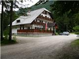
Starting point: Na Razpotju (770 m)
| Latitude/Longitude: | 46,392°N 14,6273°E |
| |
Route name: Kopinšek way
Walking time: 4 h 10 min
Difficulty: very difficult marked way
Via ferrata: B
Elevation gain: 1580 m
Elevation difference along the route: 1580 m
Map: Kamniške in Savinjske Alpe 1:50.000
Recommended equipment (summer): helmet, self belay set
Recommended equipment (winter): helmet, self belay set, ice axe, crampons
Views: 108.087
 | 6 people like this post |
Access to starting point:
We drive to Luče (to here from Mozirje or over Kranjski rak) and onwards towards Logarska dolina. Soon after the village Solčava we come to a crossroads, where the road to Logarska dolina branches off to the left. We turn left towards Logarska dolina (toll payment) and drive along the road to the signs for the mountain hut at Klemenča jama. We park on the parking lot near the guesthouse Na Razpotju. In front of the guesthouse, parking is allowed only for guests.
Route description:
From the parking lot, we head onto the forest road in the direction of Klemenča jama. After a few minutes of walking, a wide path branches off to the left towards Klemenča jama. We take this path, which starts to ascend. A fairly steep path soon brings us to steep slopes, where with the help of steel cables we cross a slightly exposed gully. The path, which continues ascending, soon brings us to the spot where a wall blocks the path. In front of us we see a cave and above it a marking that directs us into the cave. When we step into the cave, we see that it is not a cave, but a nicely made tunnel through which we continue. In the tunnel, a steel cable helps us, which we need more on the descent than on the ascent. On the other side, on a wide path in a gentle ascent, we cross an exposed ledge. The path ahead goes into the forest and continues ascending on steep slopes that are dangerous for slipping when wet. Ahead, over a small bridge, we cross another gully, then the path brings us to a less steep section, where the path from the Dom Planincev joins. We continue slightly upwards on a wide path that soon brings us out of the forest. There follows only a short ascent on a grassy slope to the mountain hut Koča na Klemenči jami.
From the mountain hut, we continue straight in the direction of Ojstrica on the path which after a few dozen meters goes into the forest. The path, which ascends moderately to steeply through the forest, brings us higher below rocky cliffs that are not overly crumbly. The path then veers right around the cliffs and brings us to a junction, where we continue left in the direction of Ojstrica on Kopinškova pot (right Škarje). Ahead we pass from the forest onto panoramic slopes overgrown with dwarf pines and individual larches, from which a nice view opens towards the northern wall of Ojstrica. There follow a few minutes of walking and the path brings us to the other side of the ridge (Škrbina 1800m).
On Škrbina, the path turns right and, crossing steep slopes above Robanov kot, brings us to the first steel cables on the path. Along the steel cable, the path ascends relatively steeply, then a somewhat less steep crossing follows again. There follows some easy climbing with the help of pegs and then a shorter vertical ascent on brackets. The path then continues to ascend quite steeply with the help of pegs and steel cables and brings us to a smaller notch, where it turns right. Here we then ascend with easier climbing towards the west and over some steep crossings reach the ridge, where a view into Logarska dolina opens again. We continue slightly left along the exposed ridge, where the path ascends steeply again along the steel cable. The path then ascends on the right (northern) side of the ridge above precipitous walls. There follows a crossing of a fairly steep scree field on which in early summer a snow patch is still possible. In case of a snow patch, use of an ice axe is mandatory, as the scree ends with a precipice. The path then turns left, ascends along the steel cable and then some easier climbing towards the summit follows.
Na Razpotju - Klemenča jama 1:10, Klemenča jama - Ojstrica 2:50.

Photos:
 1
1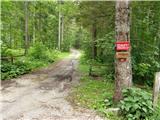 2
2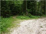 3
3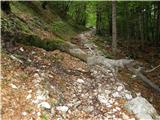 4
4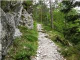 5
5 6
6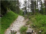 7
7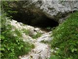 8
8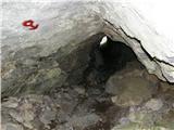 9
9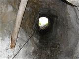 10
10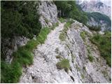 11
11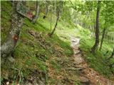 12
12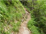 13
13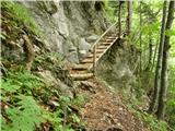 14
14 15
15 16
16 17
17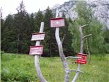 18
18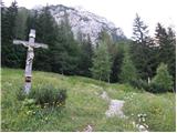 19
19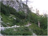 20
20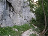 21
21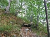 22
22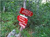 23
23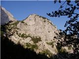 24
24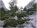 25
25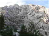 26
26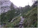 27
27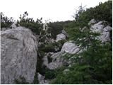 28
28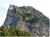 29
29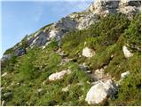 30
30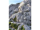 31
31 32
32 33
33 34
34 35
35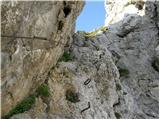 36
36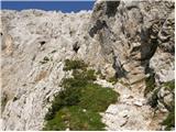 37
37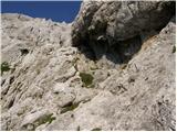 38
38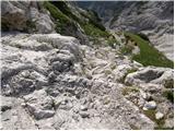 39
39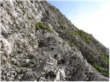 40
40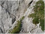 41
41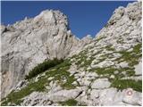 42
42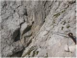 43
43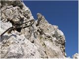 44
44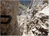 45
45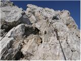 46
46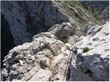 47
47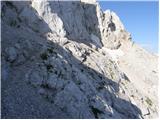 48
48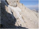 49
49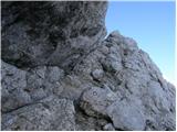 50
50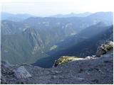 51
51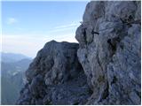 52
52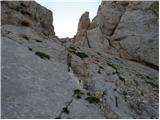 53
53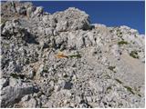 54
54 55
55
Discussion about the trip Na Razpotju - Ojstrica (Kopinšek way)
Show older messages
|
| jersy24. 08. 2008 |
Does anyone perhaps know if the difficulty can be compared to Hanz's route on Mojstrovka. Thanks for the reply!
LP
|
|
|
|
| panda25. 08. 2008 |
My personal opinion: if you managed Hanz's path to Mojstrovka, you shouldn't have trouble on Kopinškova to Ojstrica. Caution, helmet and maybe self-belay kit, then try. 
PS: If returning to Logarska dolina, try back via Škarje. A bit exposed, but well protected. Carefully.
|
|
|
|
| jersy26. 08. 2008 |
Thanks for the advice, we’ll try it!
|
|
|
|
| geppo26. 08. 2008 |
Jersy!
Do you know any other path in the Kamnik and Savinja Alps??
Lp
|
|
|
|
| geppo26. 08. 2008 |
Kopinškova path (my personal opinion!)
A path that presents no difficulties to an experienced (pegs/cables) hiker. Well protected, markings are in order - in short a path I recommend to every experienced hiker.
If you go alone and the sight of sheer walls doesn’t bother you then just go - if you’re more (we’ll try..) think twice!!
Those prone to vertigo and unaccustomed to pegs should choose
an easier approach to the summit of this beauty!
LP
|
|
|
|
| zigc.10. 10. 2008 |
has anyone been up there ...winter conditions?
|
|
|
|
| grahlck29. 01. 2009 |
I'm wondering how well this trail is secured with cables and pegs? Good or bad?
|
|
|
|
| geppo29. 01. 2009 |
Last time (before winter) everything was fine. There are quite a few cables and pegs - but where needed. So the answer is - the trail is well secured and offers nice views (Robanov kot/Logarska).
Best regards
|
|
|
|
| David Vrečko26. 05. 2009 |
Hi,
If there are no problems with vertigo, Kopinškova is super. But you have to be careful, because there are places where snow stays longer, so crossing these places can be dangerous even in summer.
So take an ice axe with you!
LP
|
|
|
|
| MARTAV29. 06. 2009 |
HI.
I've already conquered quite a few Slovene two-thousanders, including Prisank via Kopiščarjeva. Wondering if it's comparable to Ojstrica via Kopinškova. Which is harder.
Thanks.
best m.
|
|
|
|
| kindir29. 06. 2009 |
In my opinion Kopinškova path is a bit easier because the section with cables is somewhat shorter than on Kopiščarjeva path. But there is one dangerous snowfield right below the summit where snow stays long.
In any case a very beautiful, well secured path.
LP
|
|
|
|
| skrajnik26. 08. 2009 |
Has anyone been up there recently and is there still any of the mentioned snow hazards?
we're going on Friday..
|
|
|
|
| MBrando4. 06. 2010 |
Hey. Does anyone know what the conditions to the top are like? Is it icy anywhere? Ice axe and crampons? At these temps when I'll be hiking in shorts in the afternoon, it's uncomfortable to carry 2kg ice axe in addition because I only have car crampons.
Can someone tell me more?
|
|
|
|
| mvolk6. 07. 2010 |
Somewhat late reply, because we were up there last weekend, but still replying - under the summit there are still 2 snowfields. Footprints are made through them, but we decided to bypass the snowfield - carefully over the scree. Winter gear is not needed.
|
|
|
|
| brish6. 07. 2010 |
For correct information about the Kopinškova path to Ojstrica, contact the very friendly caretaker of the hut at Klemenči jama. If he advises against this path due to snowfields, rather choose the easier path from Korošica.
Safe steps to all!
|
|
|
|
| uluruslo13. 07. 2010 |
On Monday 12.7. I walked the path via Klemenčja jama and along Kopinškova pot to Ojstrica.
The very nice ascent was spoiled for me by losing my Adidas (a136) sports sunglasses. The mishap happened somewhere between Škrbina and Ojstrica summit (most likely right after Škrbina after the first cable at low pines or 15 to 10 minutes before the summit, when I was photographing Klemenčja jama and Logarska dolina on the green patch).
On the way back, I and some other hikers checked the path, but didn't find the glasses.
If by chance someone on the way to this nice summit finds the glasses, please let me know at ulurusl@yahoo.com and we'll arrange handover. Reward of course
Thanks and happy trails.
|
|
|
|
| uluruslo13. 07. 2010 |
The glasses are silver-colored.
|
|
|
|
| mikk11. 08. 2010 |
Today I walked this path, on a colleague's suggestion:-)
I have to say, the path is wonderful. But since the ground was wet, caution was needed in the forest on the roots...
The climbing was just right, in places without cables and pegs, the rocks were crumbling a lot, so one really had to be careful, especially on the descent!
At the summit itself, it was almost crowded, as we reached the top from all sides at the same moment...
..and we're already preparing for the next adventure..
|
|
|
|
| šerpa23. 08. 2010 |
Was up there on Wednesday 18.8.2010. Weather poor, otherwise protections OK except one set of three pitons that are a bit wobbly. If anyone knows who the maintainers of this route are, let them know to secure them. Return via Škarje to Klemenče jama. Must praise the hut warden - very friendly lady.
|
|
|
|
| Matjaz_6517. 07. 2011 |
a few more of my photos ... starting point at the mountaineers' hut ... ascent via Kopinškova ... descent through Škarje 
|
|
|
|
| uhan14. 08. 2011 |
Matjaz 65: How much time did you spend on the ascent and descent? Thanks
|
|
|
|
| folpo30. 08. 2011 |
who knows if on Kopinškova pot there is that snežišče mentioned in the above path description
|
|
|
|
| geppo30. 08. 2011 |
The snežišče there in that section will no longer cause problems now!
|
|
|
|
| planika13. 10. 2011 |
On Saturday there is no more snow, extremely beautiful path, safety gear also well secured. Really great
|
|
|
|
| vik22. 11. 2011 |
Does anyone know what the conditions are like these days, especially regarding snow?
|
|
|
|
| garmont22. 11. 2011 |
Check under the topic of current conditions " Ojstrica" and it will be clear to you.
Best regards
|
|
|
|
| alesh7423. 11. 2011 |
"vik" mandatory winter gear....
|
|
|
|
| jvali25. 06. 2012 |
On Saturday I heard from a relative who visited the neighboring Krofička peak that people visited Ojstrica via this path. The weather was somewhat unsuitable, as mists were racing over all the high peaks of Logarska dolina. We ourselves were on Okrešlj that day. Can someone firsthand tell how much snow is left (on that crossing) or is it better to wait a bit for the ascent on this path? Thanks. val.
|
|
|
|
| Padalka1. 07. 2012 |
Yesterday my husband and I went to Ojstrica via Klemenča jama and then along Kopinškova pot. There is no snow anywhere except on the snowfield under the summit, but just a patch, so it doesn't hinder crossing. Generally, don't go up now that it's so hot, as the path is more or less exposed to the sun. At the same time, it's worth mentioning that it's poorly marked at times... the markings are washed out, so on certain sections it's good to have someone ahead of you to follow.
|
|
|
|
| jvali13. 07. 2012 |
padalka: thanks for the information. Nice but less hot days will surely come yet, and with them my ascent of Ojstrica. Via this path I haven't reached the top yet. Best regards and safe steps, val.
|
|
|
|
| grdksmrt11. 08. 2012 |
I went to Ojstrica on this trail and unfortunately a severe thunderstorm caught us 15 minutes below the summit which besides rain also contained hail. The trail is well marked and well secured. Technically it didn't seem very demanding to me, because you always feel safe due to good pegs and cables. Perhaps it would be good to mark the descent paths a bit better at the top as we took the Kocbekova trail and needed quite a lot of time to Kocbekova koča. The trail goes around the valley and is in no way recommended for a stroll in a thunderstorm.
I strongly recommend this trail as the effort is rewarded with every step. The views compete among themselves which one will be more fascinating and dizzying.
|
|
|
|
| sebasu16. 08. 2012 |
Hi. Is the climbing section any harder than the climbing on Peco or the climbing path on Raduha. Just for comparison. Or which one would you recommend after the climbing on Raduha. Thanks for the reply.
|
|
|
|
| garmont16. 08. 2012 |
Kopinškova pot is considerably harder than both mentioned paths. But I don't understand the question. 
|
|
|
|
| Keko16. 08. 2012 |
If you want to increase the difficulty, the next could be Veliki vrh (Košuta), Storžič through the gully, then Hanzova on M. Mojstrovko, Kopinškova on Ojstrica and then you can tackle Prisank via Grebenska, via Kopiščarjeva and there are tons more in between.
|
|
|
|
| jax16. 08. 2012 |
You're underestimating Veliki vrh quite a bit. You have to know that on all other mentioned paths the descents are unproblematic, but there you have to go down the same way.
Prisojnik via grebenska is in my opinion easier than both Hanzova and Kopinškova.
Otherwise I agree with the rest. None of the listed paths (except maybe Kopiščarjeva, which I can't comment on) reaches a particularly high difficulty level.
|
|
|
|
| jax16. 08. 2012 |
Kopinškova is somewhat overrated in my opinion. As far as I remember, the harder parts are only those brackets shortly after the start (doable, but if you have issues with heights, you'll have problems there) and one awkward chimney a bit higher, where you can get stuck with your backpack (helps if you're not alone, somehow you assist each other in two). Plus that traverse above the wall, which is doable but dangerous if there's snow. That's it. For example (among nearby secured paths) the north ridge of Križ seems noticeably harder to me. Sure, that little chimney is probably harder than any spot on Križ, but it's just one spot, on Križ the difficulties pile up, and the path is much less secured. Anyway, to each their own ...
|
|
|
|
| Keko16. 08. 2012 |
I wrote a bit awkwardly about Prisank. It was meant via Kopiščarjeva uphill and then continuing along grebenska. The grebenska itself is indeed easier than those two you mention.
|
|
|
|
| sebasu17. 08. 2012 |
Yes, I meant increasing the difficulty.
Thanks for the reply.
|
|
|
|
| panda17. 08. 2012 |
Any climbing route can be difficult if you're not sufficiently physically and mentally prepared. By gradually tackling more demanding hikes, you gain quite a bit of confidence. However, there's a saying: as long as knowledge exceeds confidence, there's no problem; when confidence exceeds knowledge, an accident can happen quickly. Safe steps.
|
|
|
|
| tina.cvetka17. 08. 2012 |
Hello!
I'm interested if anyone can tell me how the snow conditions on the path are these days. Is it passable or is an ice axe needed? Thanks.
|
|
|
|
| jax17. 08. 2012 |
Let someone who has been there answer, off the top of my head: given this year's weather and the usual (non-)snow conditions in the hills, I really doubt there's any snow...
|
|
|
|
| Keko17. 08. 2012 |
If you look at the post a bit higher up from Padalka from 1.7.2012, even then the snow didn't pose any obstacles, so now you certainly don't need crampons and an ice axe.
|
|
|
|
| grdksmrt18. 08. 2012 |
Tina.Cvetka I was up there on 9.8.2012 and I don't remember any snow. It might have melted... you would surely have imprinted it in your memory.
Just boldly up, because the path offers many beautiful views... and don't forget your helmet at home!
I hope I helped...
|
|
|
|
| juhejnaprej18. 08. 2012 |
I was up there on Wednesday, 15.8., and there's no sign of any snow on the path.
|
|
|
|
| katja8720. 08. 2012 |
We also went on this tour recently and there is no snow anywhere anymore. We did a circular tour, i.e., ascended to the top via Kopinškova pot, and descended via Škarje.
Kopinškova pot is extremely beautiful, although exposed in places. It is quite an adrenaline tour, especially the ridge section that needs to be crossed, but it is well protected.
You can see the photos on the website of Planinsko društvo Matica Murska Sobota: http://www.mojalbum.com/pdmaticams/20120812-ojstrica-po-kopinskovi/foto/19952231
|
|
|
|
| jvali19. 10. 2012 |
Has anyone been to the top of this beauty via this path these days of Indian summer? What are the conditions? Thanks for a quick reply. Valerija
|
|
|
|
| papez785. 07. 2013 |
I'm interested if anyone can tell me how the snow conditions are on Kopinškova pot these days. Is it passable or is an ice axe needed? Thanks. smile
|
|
|
|
| Sini21. 07. 2013 |
Papez78, if it's not too late, I'm letting you know that there's one snow patch on Kopinškova a little below the summit. It's about 5 to 7 m wide and the footsteps are well trodden. Good luck!
|
|
|
|
| pohodnik385. 08. 2013 |
On Saturday I hiked this path and I really liked it. I started at the mountaineers' hut, the rest as described above. The snowfield below the summit no longer poses a problem on the path. Below are some video clips from the hiked path if they help someone make an easier decision to climb this path to the top.
VIDEO - Kopinškova pot to Ojstrica 2350m
|
|
|
|
| Domch6. 08. 2013 |
Nice shots, the beginning is nothing special, towards the end it's quite airy, especially there on the ridge towards the narrow chimney and then right below the summit. Did you have trouble getting through there with the backpack or what? LP
|
|
|
|
| AndrejRibic6. 08. 2013 |
Pohodnik38 there are still few such shots on the NET. Some relive what we have climbed, others see if they can manage this path or not.
Praise, more such shots. Nice. Good luck with climbing.
|
|
|
|
| jocjoc6. 08. 2013 |
Wonderful shot of Kopinškova pot; I think many will decide more easily for or against it.
|
|
|
|
| pohodnik386. 08. 2013 |
@Domch yes, it's quite narrow there but you can squeeze through... and a bit before that it's airy and also ahead from the chimney but you walk along the walls, the view is... super, you have to try it.
|
|
|
|
| erikaleon15. 08. 2013 |
I'm interested if anyone knows a comparison between Kopinškova to Ojstrica and Through the Gully to Storžič, which we have already done with my wife. Thanks in advance for comments and opinions.
|
|
|
|
| Betalord15. 08. 2013 |
Regarding the difficulty of the via ferrata, since there were some questions in between: this via ferrata is very well secured, so it's neither dangerous nor adrenaline-pumping. For example, the one to Jalovec via Jalovška Škrbina is more "wild", and also the one from Češka Koča up via Mlinarjevo Sedlo (and then further to Skuta for example) is more demanding.
|
|
|
|
| miha8627. 08. 2013 |
Hi!
Is anyone maybe going to Ojstrica on 30.8.2013 if the weather is good. I'd rather go in a pair than alone.
|
|
|
|
| samsonite21. 07. 2014 |
Hello, I'm interested in the difficulty of the Kopinškova path to Ojstrica compared to the path from Dom na Okrešlju to Brana - I plan the descent from Ojstrica via Škarji.
Thanks!
|
|
|
|
| Daaam21. 07. 2014 |
Kopinškova is much more demanding..
|
|
|
|
| samsonite21. 07. 2014 |
Ugly! I'd better forget about this path until I get used to it
|
|
|
|
| jax21. 07. 2014 |
It's not that horribly demanding. In my opinion, Kopinškova is one of the paths that is slightly overestimated in descriptions. In reality, it has only one slightly tricky spot in the steep chimney where you can easily get stuck with a backpack, plus that crossing above the north face which is not difficult but can be insidious if there's still snow. The rest is more or less unproblematic, especially well secured, far above the usual standard in the Kamnik Alps.
Brana, on the other hand, is a more "typical" path in the Kamniks - not overly demanding, but with some delicate unsecured sections. And of course, there's also a dangerously snowy crossing there. Now, definitely Kopinškova is harder. But overall, it's no bogeyman and if you're eyeing slightly harder paths in our mountains, it can be a good choice to start. In any case, in the current conditions, it's appropriate to wait a bit more until things settle somewhat.
|
|
|
|
| redbull21. 07. 2014 |
I agree with Jax,, the initial part and that narrow part are a bit harder, otherwise the whole trail is hiking. Now wait a few more weeks and head out mid-August, then there definitely won't be even a patch on the marked trail.
regards
Good luck
D
|
|
|
|
| spela.jarc22. 07. 2014 |
Hi, has anyone been to Ojstrica via Kopinškova in the last few days? Please for useful info.. how about winter gear, snowshoes,..? thanks everyone!
|
|
|
|
| redbull22. 07. 2014 |
Again you're babbling nonsense.. for such questions there's the Ojstrica conditions forum.
If you have experience crossing snow, then no problem, and even without winter gear people are already walking. But if it's a regular Sunday hiker then I advise against this tour for another 2 weeks.
no hard feelings
best
D
|
|
|
|
| ms_primoz22. 07. 2014 |
redbull - you know, some people aren't on hribi.net all day and we have other things to do in life than just boost our ego on the forum. If someone asks something, answer or be quiet. You're not the only one who's right. Especially be nice to people on the forum who ask (even if not on the conditions forum).
|
|
|
|
| ms_primoz22. 07. 2014 |
yeah that's why the forum has you...
|
|
|
|
| spela.jarc22. 07. 2014 |
I'm sorry. I didn't know that questions about conditions are exclusively on the forum! I've already hiked a lot, conditioning is no problem for me... I'm only worried about snowfields-I've already read about them, but I don't have an ice axe. I only have crampons-the basic ones.
|
|
|
|
| redbull23. 07. 2014 |
no panic, you're not the only one. safe steps
best regards
|
|
|
|
| zdravc6910. 10. 2014 |
Today up this path and then down via Škarje. Start without clouds, at the top wind, rain, cold, everything... Path nicely secured, not overly difficult. No snow under summit on scree but scree dangerously slippery as soon as you step on it, need to be really careful and through as fast as possible.
Autumn colors made the nice tour even more beautiful
|
|
|
|
| Marx22. 06. 2015 |
Was on the trail yesterday, 21.06. On the scree there was some fresh snow (which has melted by now) and a snowfield. But the snowfield is no problem at all because the snow is wet and footsteps are made. There were four of us and we went without winter gear, no problems at all.
|
|
|
|
| zipo10. 07. 2015 |
Hello! I have a question about the difficulty of this path. I've already climbed Mrzla gora and wonder if anyone can compare these two paths in terms of difficulty. Thanks!
|
|
|
|
| Viper10. 07. 2015 |
Just saying that the path to Mrzla gora is more demanding.
|
|
|
|
| zico1010. 07. 2015 |
@zipo, Kopinškova is nothing special, where it's precipitous or exposed there are safety devices in excellent condition... Mrzla gora is definitely more demanding...
|
|
|
|
| Sujcic19. 07. 2015 |
Does anyone know the condition of the snowfield on pic. 49?
|
|
|
|
| geppo19. 07. 2015 |
You won't have problems. Just start early enough in the morning so you don't overheat on the return via Škarje
lp
|
|
|
|
| redbull19. 07. 2015 |
if only there was still some snow to refresh ourselves,,it's been a long time since that snow on no.49 was still there
good luck
|
|
|
|
| malimiha5. 08. 2015 |
This weekend I plan to go via Kopinškova to Ojstrica. For the descent, I planned to go via Škarjev rob. I'm interested where the junction for this part of the path is? Is it at the hut at Korošica or already at the top of Ojstrica? Thanks and lp, Miha
|
|
|
|
| otiv5. 08. 2015 |
@malimiha, there are two junctions for Škarje, the first one shortly after descending from the top of Ojstrica and the second somewhere halfway on the path towards Korošica.
|
|
|
|
| panda5. 08. 2015 |
malimiha: the path via Škarjev rob leads to Storžič. The direct ascent or descent via Škarje from/to Ojstrica was described to you by Otiv.
|
|
|
|
| Janez Seliškar5. 08. 2015 |
Why doesn't forum user "malimiha" look at the hiking map, in paper or electronic form?
|
|
|
|
| malimiha5. 08. 2015 |
otiv - thanks for the info
panda - yes, my mistake in writing
thanks and lp
|
|
|
|
| dprapr5. 08. 2015 |
True, on the map above, above the photos, all junctions to Škarje are nicely drawn!
|
|
|
|
| garmont5. 08. 2015 |
There are actually three junctions to Škarje. The only sensible one is to take the first (at the iron wheel), because you lose the least altitude there.
|
|
|
|
| lakkon8. 08. 2015 |
So far I have some experience with climbing secured paths, here and there even bypassing them... The first time I went into something at least a bit more serious was probably Ravenska Kočna - Kranjska koča na Ledinah (Slovenska pot), where I learned on the spot in practice to use the self-belay kit. But I didn't actually use it, as I feel OK while climbing + not afraid of heights + I think ahead if there's a more critical situation, where to grab and where to step, etc... since then I haven't been on via ferratas much... also on the path Aljažev dom v Vratih - Triglav (Tominškova pot) I had the self-belay kit with me, on me, but didn't use it... last time Jalovec without protections didn't pose problems (up via Goličica, down to the bivouac pod špičkom)... I know and realize that an animal, another hiker can make a slip, and consequently without protection I might end up hurting myself... I'm also quite inclined to photography... and for this path it says in the book on secured climbing paths that there's 550m of climbing... so: take the self-belay kit or not?... I'll descend to the hut na Korošici and then back via Škarje... it'll be a bit long path to carry everything I might not really need... Thanks for help
|
|
|
|
| Keko8. 08. 2015 |
I won't tell you whether to take it or not, because everyone should decide that for themselves.
I can only say that, given what you listed above, Kopinškova doesn't stand out from them in any way.
|
|
|
|
| Ksandarela1. 09. 2015 |
I always just read and never comment... But this path I must over the weekend my colleague and I hiked the path from Brana over Kamniško Sedlo, then to Planjava and down to Kocbekov dom, the last day we also took on the ascent to Ojstrica from Korošica, which was incidentally wonderful At the top we decided to descend to Klemenče Jama via Kopinškova, since we both like climbing and don't like downhill walking on scree and talus. And we decided super, as the path was full of adrenaline pleasures! For me so far the nicest path in the Alps, many wonderful views of surrounding mountains and valleys, even more abysses and steep descents  I recommend the path to everyone who loves climbing, even self-belay not needed, because more pitons than cables! But I would mention special caution on descent through that chimney a little before the summit... I almost got stuck in the middle, I needed a good minute or two to think well how and where to put left and right foot... I even started shaking a bit when I felt the abyss under and behind me... Carefully, with firm step, self-confidence and respect for the Mountain I recommend the path to everyone who loves climbing, even self-belay not needed, because more pitons than cables! But I would mention special caution on descent through that chimney a little before the summit... I almost got stuck in the middle, I needed a good minute or two to think well how and where to put left and right foot... I even started shaking a bit when I felt the abyss under and behind me... Carefully, with firm step, self-confidence and respect for the Mountain
|
|
|
|
| acjom12. 11. 2015 |
Hello, has anyone perhaps gone on this path to Ojstrica these days? Is there any snow?
|
|
|
|
| andr3ejj18. 08. 2016 |
Hi. Curious if Kopinškova can be compared to the ascent to Velika K. Baba via the climbing path, and before that through Žrelo? Or say the ascent to Triglav? Thanks
|
|
|
|
| Domch18. 08. 2016 |
Kopinškova path is one of the most beautiful here. Personally my favorite. Difficulty-wise comparable to those you mentioned, say Kremžarjeva to Jezersko Kočna. Fitness-wise quite demanding, because if you want back to Logarska you have option via Škarje, which is longer and most often chosen for descent. I think you won't regret going on it and you'll be thrilled by the path's course and beautiful views around. No snow under the summit anymore. Helmet mandatory.
|
|
|
|
| B218. 08. 2016 |
I wouldn't say it's comparable to the path to V. Koroška Baba (no pegs or staples, no vertical walls), nor through Žrelo (to Ledine). Also Kremžarjeva path to Kočna is much harder than Kopinškova to Ojstrica. On Kopinškova there is considerable exposure in some places, but nowhere direct "drop" like on all previously mentioned paths. In short, Kopinškova to Ojstrica is not to be underestimated, but for experienced hiker no "bav-bav"...
|
|
|
|
| Domch2. 09. 2016 |
Opinions vary, depending on what is harder or more uncomfortable for whom. Kopinškova also has two chimney climbs straight up (chimney before the scree), a very uncomfortable and steep scree to cross, it's longer than Kremžarjeva and V. Baba, starts at lower elevation, meaning more elevation gain, etc. In short, if you consider all factors, they are in the same range, one path has more of this, less of that, the other vice versa. I agree, all paths are to be respected but not baaad.baaad.
|
|
|
|
| redbull2. 09. 2016 |
Just sign under statement B2
super written
|
|
|
|
| dprapr2. 09. 2016 |
That Kremžarjeva path to Kočna is much harder than Kopinškova?
Both have a "difficult" spot, Kopinškova further in summer snowfield that shouldn't be underestimated, Kremžarjeva that low, unprotected crossing above the abyss. Otherwise no big difference.
The path to Koroška Baba is not comparable, as it belongs more to the rank of paths like to Mrzlo goro (less secured, more scrambling).
Comparing these paths with that short crossing through Žrelo doesn't make sense. There the main issue is objective danger of falling rocks.
|
|
|
|
| redbull3. 09. 2016 |
We can forget that snowfield, if someone rushes up when the snowy pass is already visible at the entrance to Logarska, it's downright strange. Speaking only for summer hikers
|
|
|
|
| zokipoki9. 09. 2016 |
Tone, great video.. Best regards
|
|
|
|
| cebelicaU20. 09. 2017 |
Hi! Is the path dry or snowy? I plan to ascend on Saturday, 23.9.2017.
Thanks in advance, LP, čebelica.
|
|
|
|
| biba20. 09. 2017 |
Today (probably) snowy... check the webcams in the area.. lp
|
|
|
|
| garmont21. 09. 2017 |
There is quite a bit of snow. Better go somewhere else...
|
|
|
|
| redbull21. 09. 2017 |
do you want snow or a dry path? You didn't say anything.
conditions on the northern traverse are surely not that great if you're not well trained in crossing with crampons.
You'll have to wait for a dry path until next year
Good luck
|
|
|
|
| Arsen11. 10. 2017 |
Hello, has anyone perhaps gone on this path to Ojstrica in these days? Is there any snow?
|
|
|
|
| Martin kokot3024. 06. 2018 |
And does anyone know if the path is passable without crampons?
|
|
|
|
| Jigga2. 07. 2018 |
I can confirm that this snowfield can be bypassed, but carefully, the scree is very crumbly and you can slip quickly.
|
|
|
|
| Jigga2. 07. 2018 |
Otherwise there were no living souls on this path when my colleague and I went there two days ago on Saturday morning.
|
|
|
|
| green11. 08. 2019 |
What is the condition of the trail and the safety equipment on Kopinškova and for the descent via Škarje?
Thank you, you are great
|
|
|
|
| tomazcopo14. 07. 2020 |
The path is super. Crossing the snowfield on the north side is also possible, but carefully!
|
|
|
|
| aloha16. 07. 2020 |
Yesterday I lost my keys with a silver keychain from Prague on the trail. If anyone finds them, I would be very grateful if you call me at 041 265 277.
Thanks
|
|
|
|
| JBoogie5. 07. 2021 13:19:40 |
Does anyone perhaps know if there's still a lot of snow on the Kopinškova path to Ojstrica? Are microspikes sufficient for crossing the snowfields?
|
|
|
|
| ewok9956. 07. 2023 15:05:01 |
Has anyone been on this trail recently, how is the snow?
|
|
|
|
| zan9510. 07. 2023 16:00:54 |
|
|
|
|
| ŠpRo2928. 07. 2023 10:47:05 |
Hey, how is it now with that snow patch? Thanks.
|
|
|
|
| kpt22. 06. 2024 19:30:05 |
How is it with the snowfield?
|
|
|
|
| garmont22. 06. 2024 22:01:57 |
The snowfield is still quite large. Checked two days ago.
|
|
|
|
| Chasethesun6. 07. 2024 11:47:13 |
How is the snowfield situation now?
|
|
|
|
| ravnjak19. 06. 2025 12:24:12 |
Or blue? Does anyone know how it is with the snowfield under OJSTRICA on Kopinškova
|
|
|
|
| innuendo31. 07. 2025 18:33:23 |
Today I did the route to Ojstrica via Kopinškova. Very nicely routed path, the climbing section starts around 1850 meters. The path is suitable for experienced hikers, mainly due to the large elevation gain. The hardest part comes after we're already a bit tired. The path is somewhat less traceable in places, as the markers have faded considerably and sometimes you don't see the next one right away (can be more of a problem in fog). Definitely one of the more demanding in the KS Alps, especially since it's not secured in many places. Those who rely on a via ferrata set for safety might have issues, as there aren't many cables. Mostly it's easy scrambling, aided by pegs in places. The terrain is crumbly in spots. The seriousness of the tour is also contributed by the exposed ambience with deep views down in places
|
|
|
|
| štopl5. 08. 2025 22:19:04 |
With colleagues, we plan to go to Ojstrica via Kopinškova pot starting from Na Razpotju next Monday.
I noticed that the section of the path from the Na Razpotju parking lot to the hut at Klemenčeva jama is supposedly closed.
Has anyone gone on this path recently and is it true that it's closed or is it passable?
|
|
|
|
| DVas6. 08. 2025 07:52:50 |
Everything OK with the path.
|
|
|
|
| štopl10. 08. 2025 21:10:20 |
|
|
|
|
| Hribolazec8112. 08. 2025 13:55:38 |
The trail is normal to Klemenče, only one platform / bridge to bypass, which was destroyed by water, so the trail is fine.
|
|
|
To post a comment you must log in:
If you do not yet have a username, you must first
register.