Ljubelj - Selenitza/Palec
Starting point: Ljubelj (1058 m)
| Latitude/Longitude: | 46,4324°N 14,2602°E |
| |
Walking time: 3 h
Difficulty: difficult unmarked way
Elevation gain: 968 m
Elevation difference along the route: 975 m
Map: Karavanke - osrednji del 1:50.000
Recommended equipment (summer): helmet
Recommended equipment (winter): helmet, ice axe, crampons
Views: 60.905
 | 5 people like this post |
Access to starting point:
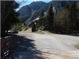
From the highway Ljubljana - Jesenice we go to the exit Ljubelj and follow the road ahead to the border crossing. Only a few meters before the border crossing signs for Zelenica point us to the left and after a few 10 meters of additional driving the road brings us to a parking lot below the ski center Zelenica.
Route description:
At the beginning of the parking lot the signposts for Stol, Vrtača and Dom na Zelenici point us onto a wide cart track which starts ascending by the torrent. When a little higher the cart track turns left, we continue straight on the mountain path which continues through the forest and soon returns to the cart track. The cart track a little higher turns right and brings us out of the forest onto a ski track of the former ski slope Zelenica. Next follows a short steeper ascent on the ski slope, and then the path flattens and leads us by the foot of the scree below Begunjščica.
From the marked path soon a path which runs on a transport road branches off to the right, and we continue on the "road" to the nearby hut Koča Vrtača.
At the mountain hut, the road turns right, and we continue straight in the direction of the mountain path to Zelenica. For a short time we continue below the former one-seater chairlift Zelenica II, and then the path starts ascending steeper on a slope, which is partly overgrown by dwarf pines. After a few hairpin turns, we return to the transport road, on which we continue with a view towards the gully Šentanski plaz.
The path ahead leads us on slopes of Spodnji plot (peak, on which they made a sport climbing path years ago), after that from the road we turn right onto a footpath which cuts a longer turn. When we return to the road we are already at the upper station of the former one-seater chairlift Zelenica II, and only a few steps of descent separate us from the mountain hut Dom na Zelenici.
After the mountain hut, we continue left and ascend to half of the children's ski lift, and then on the right we notice signs for Vrtača and Stol, which point us to the right into a belt of forest. A little further, we cross a connecting lane between the children's ski lift and anchor lift, and then we cross also the other ski track.
We find the continuation of the path at a smaller boulder, and then we cross slopes below the ridge Na Možeh. When the crossing ends, we arrive in an indistinct little valley, where the path branches off to the right into Suho ruševje (by the branch-off there is usually a cairn).
The path into Suho ruševje first ascends through the forest (sharply right path on the scree, option for descent), and then passes among dwarf pines, where the path is well beaten, and the dwarf pines are cut. Next follows a short steeper ascent, where when we look back a nice view opens up on Begunjščica, and in front of us on the left we see Vrtača, straight ahead Zelenjak, and right Palec and the ridge Na Možeh. Higher the footpath flattens a little and passes into a high mountain valley, which gradually narrows. A little further the footpath turns right and then joins the path which leads on the scree below the ridge Na Možeh (mentioned path is more appropriate for descent than ascent). We continue left and on the scree we start ascending diagonally, and we follow such a path all the way to Žleb, which is situated between Zelenjak and Palec.
From Žleb, from where a nice view opens up into Austria, we continue right (left Zelenjak), where we still walk on a followable path. The path ahead ascends diagonally towards the right, where we quickly arrive at a wider, partly crumbly, but not too steep gully, which we cross. On the other side of the gully, we start steeply ascending, and the path a little ahead brings us to the ridge of Palec, from where a nice view opens up on the ridge Na Možeh, and the view reaches far towards the east. Next follows a short steep rocky jump, where we have to help ourselves with our hands. Above the jump, the path flattens a little, but still steeply ascends towards the summit of Palec, which we also reach in a few minutes of additional ascent, with nice views.
Ljubelj - Zelenica 1:20, Zelenica - Palec 1:40.

Photos:
 1
1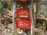 2
2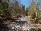 3
3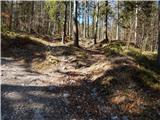 4
4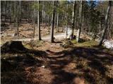 5
5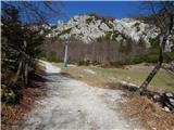 6
6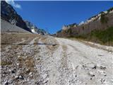 7
7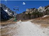 8
8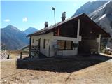 9
9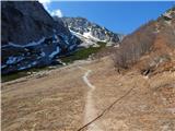 10
10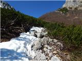 11
11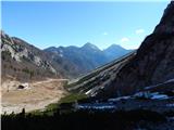 12
12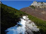 13
13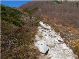 14
14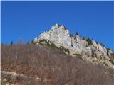 15
15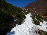 16
16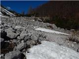 17
17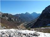 18
18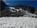 19
19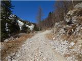 20
20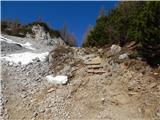 21
21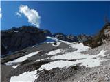 22
22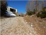 23
23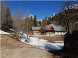 24
24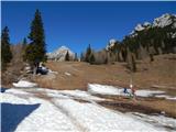 25
25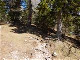 26
26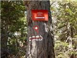 27
27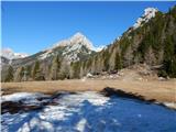 28
28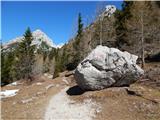 29
29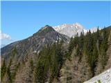 30
30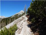 31
31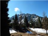 32
32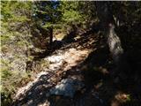 33
33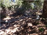 34
34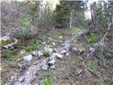 35
35 36
36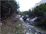 37
37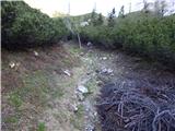 38
38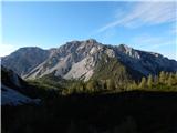 39
39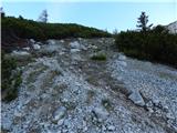 40
40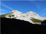 41
41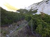 42
42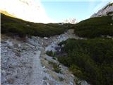 43
43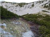 44
44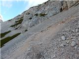 45
45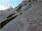 46
46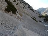 47
47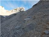 48
48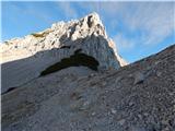 49
49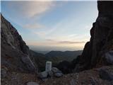 50
50 51
51 52
52 53
53 54
54 55
55 56
56 57
57 58
58 59
59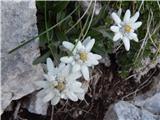 60
60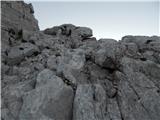 61
61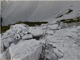 62
62 63
63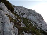 64
64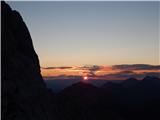 65
65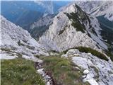 66
66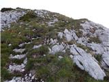 67
67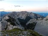 68
68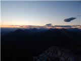 69
69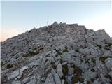 70
70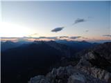 71
71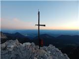 72
72
Discussion about the trip Ljubelj - Selenitza/Palec
Show older messages
|
| Gost14. 09. 2006 |
I was on Palec in June and it's a great tour. When I studied descriptions in various guidebooks, I was a bit scared. It's a respectable approach, not as scary as presented in some descriptions. Especially I like it because I got among few hikers and there were just right. Definitely on certain sections of the path you have to be very careful. I really recommend it to those who enjoy peace and quiet. Heartily!
|
|
|
|
| Gost15. 09. 2006 |
I fully agree with the guest before me. Beauty, peace, cairns and really worthwhile tour. Edelweiss on the scree. Not to mention winter ski touring descent. Try it!
|
|
|
|
| kolesar19. 02. 2007 |
Are ice axe and 10-12 point crampons necessary for the winter approach or can one do without?
|
|
|
|
| Gost2. 09. 2007 |
Today I went to Palec. Very nice at the summit itself. The path is fine too. Friendly people at Zelenica. Come and see. Marjan
|
|
|
|
| Gost3. 09. 2007 |
The hike to Palec is really nice, but the hut at Zelenica is not worth wasting words on.
|
|
|
|
| Gost4. 09. 2007 |
Let's have understanding for the hut at Zelenica. As far as I know, it is under construction. Let's wait until it's finished, maybe the conditions will improve then. If not, we'll criticize.
|
|
|
|
| Gost4. 09. 2007 |
Everyone can see that there is a huge hut under construction, which has nothing to do with the current tenant.
|
|
|
|
| andrej jerina9. 09. 2008 |
I also set off today to the oasis of peace, where a chamois greeted me on the "border path" towards Zelenica, followed by a ptarmigan. I ascended to Palec via the "upper" path of Suhega ruševja over scree fields, completed the ascent in beautiful weather (there was fog in the valley), descended and then climbed both peaks of Zelenjaka, from where there was a nice view of the nearby peaks, the Julian Alps and Veliki Klek. For the descent, I chose the "lower path" through Suho Ruševje, which turned out to be a good choice, as you walk among pines and grassy carpets. Larches are already taking on their autumn appearance, and edelweiss are slowly departing, with quite a few of them. I recommend a helmet. LP Andrej
|
|
|
|
| grahlck6. 06. 2009 |
Is there still any snow here?
|
|
|
|
| anda15. 06. 2009 |
On Saturday we were at Zelenjak and Palec, no snow anymore, the tour is really nice, recommended.
|
|
|
|
| heinz22. 07. 2009 |
During the descent, some caution is needed due to scree on the path and orientation in the area of the rocky jump.
At the top, wonderful.
|
|
|
|
| veseljak762. 08. 2009 |
Yesterday I visited Palec and Zelenjak with friends. Both summits have a summit book, stamp and nice views. The path is unmarked, demanding only a little below the summits where some climbing is needed. However, the start of the path could be marked at least on the Zelenica-Stol path, as stated in the above description. It isn't there.
|
|
|
|
| nata2412. 08. 2009 |
If I go first to Palec and then to Zelenjak, or is there another path for descent to Zelenica or Ljubelj, so as not to walk the same path twice. Best, Nataša
|
|
|
|
| jusuf18. 08. 2009 |
On the path from Zelenica towards Stol after about 15 min of walking, we turn right. A cairn by the path warns us (it was still there on 9.8.09). Immediately we have two choices: left through the bushes (quite overgrown this year) and right across the scree. The paths join just below the Žleb saddle. From the gully it's only about 20 min to the top.
An alternative is to climb right on our own before Suhega ruševja to the border ridge, but we do this for the sake of the horns on Na Možeh. Then we follow the ridge to the top of Palec.
|
|
|
|
| upornica24. 08. 2009 |
The marker by the path is still there. I hope it stays because otherwise the path is hard to spot.
|
|
|
|
| nata2424. 08. 2009 |
Yesterday I was on Palec and Zelenjak. The marker by the path is really barely noticeable and if you're not careful enough you pass it quickly. Further on the path is well visible and quite overgrown, as Jusuf already wrote. But it was quite windy and there was fog in the morning too so there were no views.
|
|
|
|
| JusAvgustin6. 12. 2009 |
Today we tried to conquer Palec, but due to poor snow conditions (unpacked snow, powder, steepness, no support for feet) the attempt failed. Still, the weather was pleasant, not too cold, good company and winter idyll. It will have to wait until next time. In the meantime, I'll go somewhere else. Despite proper gear (full winter equipment), the snow wasn't right to go up. On the way back, we saw a fresh avalanche on the Šentanski plaz under Begunjščica. What can I say... great day, even though we didn't reach the desired goal, lots of satisfaction. A smart mountaineer, hiker, alpinist knows when to turn back. Still, the weather was pleasant, not too cold, good company and winter idyll. It will have to wait until next time. In the meantime, I'll go somewhere else. Despite proper gear (full winter equipment), the snow wasn't right to go up. On the way back, we saw a fresh avalanche on the Šentanski plaz under Begunjščica. What can I say... great day, even though we didn't reach the desired goal, lots of satisfaction. A smart mountaineer, hiker, alpinist knows when to turn back.
Best regards to forum members, and a merry St. Nicholas without rods. 
|
|
|
|
| nata2411. 06. 2010 |
Has anyone been to Palec or Zelenjak in the last days. I'm wondering if there's still any snow. Lp
|
|
|
|
| miham11. 06. 2010 |
From Vrtača and Suhega rušja it wasn't visible yesterday.
LP
|
|
|
|
| Edina11. 06. 2010 |
I was on Palec and Zelenjak yesterday. It was very windy, crampons and ice axe made the backpack heavier, but they weren't needed as there's no snow anymore.
Good luck and best regards
|
|
|
|
| grega_p27. 05. 2011 |
Today I intended to go to Palec, but I turned too early onto a smaller branch right, which took me to the ridge Na Možeh (horns). It wasn't really a path, more walking through scree. Also down to Zelenica I went my own way and collected some scratches and experienced crumbly climbing. So, watch out hikers (the mentioned branch is a bit after the big rock - at the bilberry spot).
Maybe someone knows if this path from the ridge leads where - remains of overgrown path are visible?
|
|
|
|
| JusAvgustin27. 05. 2011 |
http://www.hribi.net/trenutnerazmere.asp?slo=1&gorovjeid=11&id=3298 that is the connecting ridge between Ljubelj and Stol. We two went "only" from Na Možeh to Palec... And there is no official path, but very demanding pathless terrain, traces of a path are there, but they get lost quickly... You however came up another three hours from Palec (along the ridge), to the saddle between the last Mož and the beginning of the Palec ridge...
|
|
|
|
| grega_p27. 05. 2011 |
Thanks for the explanation and description of the super tour, probably in winter it's easier to do (in good conditions), currently the ridge is a struggle with scree...
|
|
|
|
| velkavrh14. 06. 2011 |
Today unintentionally conquered this Karawanks two-thousander, because after the hut at Zelenica I turned right too soon. Since I started very early, the wet bushes caressed me all the way through the bushes. It really needs to be trimmed as Grega before me already mentioned. Otherwise, it's an easy path, two hours long from the hut. You just need to be careful at the entry into the Palec rocks and watch not to get off track, because some passages are less noticeable.
|
|
|
|
| JusAvgustin14. 06. 2011 |
I am explicitly against cutting dwarf pines or any intervention in the "pines" . Otherwise, there are cairns all the way that lead you completely without dwarf pines to the head of Suhega ruševja, that is indeed the name of the cirque between Vrtača and the continuing ridge to Mož... Palec is unmarked, pathless terrain, for some it can be a serious challenge, so the adjective easy path doesn't apply here, the approach is much easier in winter as there is no annoying loose gully and rockfall before the summit. Palec has all passages "marked" with cairns. . Otherwise, there are cairns all the way that lead you completely without dwarf pines to the head of Suhega ruševja, that is indeed the name of the cirque between Vrtača and the continuing ridge to Mož... Palec is unmarked, pathless terrain, for some it can be a serious challenge, so the adjective easy path doesn't apply here, the approach is much easier in winter as there is no annoying loose gully and rockfall before the summit. Palec has all passages "marked" with cairns.
|
|
|
|
| robter14. 06. 2011 |
If before entering the dwarf pines you turn more to the right and ascend over the scree where a "pathlet" is visible, you completely avoid the dwarf pines and reach the saddle between Palec and Zelenjak without problems.
|
|
|
|
| turbo14. 06. 2011 |
That's right, from the marked path right and not slightly left along the more gravelly and visible one but slightly right upwards, through the forest without dwarf pines and you reach a large boulder. From the boulder up the scree, you reach a visible track from below, then left steadily slightly upwards and you reach the border sign at the top of Žleb. Especially when the dwarf pines are wet, a better choice.
|
|
|
|
| velkavrh14. 06. 2011 |
JusAvgustin, I agree with you. Only marked paths really need to be cleared and maintained. So cutting dwarf pines on unmarked paths is out. I wanted to say that the path to Palec is not demanding. For Palec, I can't say it's pathless because the pathlet is well visible and safely leads you to the summit. So it's an unmarked path that really isn't for everyone. True, Stanko's Klinar guide describes it as pathless. As far as I know, a completely new Karavanke hiking guide from PZS by a completely new young author has just been published, who supposedly hiked all paths himself and described many anew. I need to get it. Otherwise, I'm happy for every well-intentioned advice and gladly follow it. Best regards.
|
|
|
|
| heinz15. 06. 2011 |
From Žleb to Palec it's possible to get lost.., e.g. if there were no cairns, or if you miss one. It's definitely pathless terrain, as in the mentioned case the trace is lost. As for orientation difficulty, it's easier pathless terrain, but regarding technical difficulty it's a demanding >path<, because in places it requires use of hands. In my personal view, the demanding rating mainly applies to the descent.
|
|
|
|
| velkavrh15. 06. 2011 |
Heinz, I have no experience with rating, I just share my view of the path I hike. I don't know where Žleb is. Anyway, when we start ascending the mountain itself, the pathlet is well visible and doesn't get lost. I folded the poles soon at the beginning because hands are really needed. You're right about the descent. I really hiked Palec and Zelenjak for the first time. It was interesting, especially for me the climbing challenge on Zelenjak. Best regards.
|
|
|
|
| klm15. 06. 2011 |
I simply don't understand something: every time I go to Vrtača, I run along this gently ascending path, but never, absolutely never do I miss or overlook the junction into the gully. If you're walking, the speed is 2/3 slower, so the junction is even more visible. The dwarf pines are just as much a living being as e.g. bear, viper, chamois or toad. We have come to its territory and if it's in someone's way, it will move aside or one will push through it so I join Jušo's thought that dwarf pines on such paths should not be cut. so I join Jušo's thought that dwarf pines on such paths should not be cut.
|
|
|
|
| velkavrh15. 06. 2011 |
Well, klm, no panic, if I had wanted to turn back when I realized there were no markers, I would have, but since I have a bit of adventurous and exploratory spirit, I continued and thus reached Zelenjak and then Palec, although the tour was not planned. I believe those younger than me judge better which path is right or study a new tour better. Best regards.
|
|
|
|
| turbo15. 06. 2011 |
No offense, but Palec through Suho rušje is such a fun tour that it's perfectly suitable for those just starting with off-trail hiking. Below you have to "find your way" to catch the junction (cairn, path, visible), completely above on "rough" terrain you have to watch your step. If someone has orientation and/or technical difficulties on this tour, they should rather avoid similar tours or tackle them with more experienced companions.
|
|
|
|
| heinz15. 06. 2011 |
Well, the comment went somewhere..
I say that regarding the word >difficulties< it's not that bad.
On Palec, orientation d. are rated 2 (scale 1-5). Technical little difficulties of course exist. The other thing is whether you know how to solve them.
For a beginner, solo dealing with such difficulties is certainly the most valuable.
|
|
|
|
| Potohodnik13. 04. 2014 |
For this time of year: which is technically more demanding goal, Palec or Zelenjak?
Thanks in advance.
|
|
|
|
| Grenaleva19. 10. 2015 |
Junction from the path to Vrtača, no longer marked with a cairn, you have to search for it, about 20 minutes from the hut at Zelenica
|
|
|
|
| tinky19. 10. 2015 |
The cairn was still there at the end of August.
|
|
|
|
| lino19. 10. 2015 |
If I'm mean, maybe they stole it.
|
|
|
|
| tinky19. 10. 2015 |
Lino, they didn't steal it, but they knock them down, those who have no business in the mountains. It has already happened right here. Such a cairn was here before.
|
|
|
|
| lino19. 10. 2015 |
Tinky, I already wrote the comment under Forum - Conditions, so I won't repeat it here.
|
|
|
|
| Grenaleva19. 10. 2015 |
Once the junction is found, the path straight through the brush is nicely traceable, from the gully onwards it is snowy and slippery.
|
|
|
|
| Fulcrum2. 07. 2016 |
Today on Zelenjak and Palec from Ljubelj. The cairn marking the junction to the unmarked path leading to the summits is back in place. The junction is about 15-20 minutes walk from the hut on Zelenica.
|
|
|
|
| tango9. 11. 2018 |
Excellent tour for this autumn time. Only advice. If need arises, better pee below the summit, as alpine choughs are incredible! If necessary they land even on the head (not yours) so they get as close as possible to the bite
|
|
|
|
| ločanka9. 11. 2018 |
Who has spoiled them so much?
|
|
|
|
| Kanjanez16. 10. 2021 23:24:13 |
Easy off-trail - at least in winter conditions, when you bushwhack it a bit your own way
There today - conditions super. Thrilled by the stamps (which we don't expect on pathless 2000ers).
|
|
|
|
| J.P.24. 10. 2021 21:44:46 |
Easy off-trail because the path is always nicely traceable and trodden. (dry conditions, some snow patches did not reduce traceability.) The cairn is still standing at the junction
|
|
|
|
| Mona6. 08. 2023 10:04:08 |
I'm wondering, given the current flood conditions,... is it possible from the Ljubelj starting point to reach Palec or is the path perhaps destroyed or dangerous.
Thanks for the help
|
|
|
|
| _sandra_6. 08. 2023 11:01:47 |
Better wait a while with the mountains…
G2-101, Tržič - Ljubelj, alternating one-way traffic, landslide, on several sections.
Source:
Directorate RS for Infrastructure
|
|
|
|
| jax7. 08. 2023 14:19:48 |
I think it should be fine. You can already reach Zelenica via the ski slope but there the conditions are in question. I would think that actually higher up it's better than lower. In any case assess the situation on the ground and turn back if necessary.
|
|
|
|
| nteam7. 08. 2023 15:29:10 |
It's an extremely inappropriate time for carrying out mountain adventures that you doubt you are capable of doing on your own.
|
|
|
|
| orchigu27. 09. 2023 20:13:39 |
Hiked today. Fun tour, but quite a lot of walking on this or that scree (I'm not a big fan of scree even to Zelenica, I admit ). Cairns are in place, path clearly visible, only from the junction at the saddle (right Palec, left Zelenjak) the last ascent requires a bit more attention, one short section is a bit more scree-like and slippery and once in between the path gets lost a bit - climb over one or two rocks and you're back on track. ). Cairns are in place, path clearly visible, only from the junction at the saddle (right Palec, left Zelenjak) the last ascent requires a bit more attention, one short section is a bit more scree-like and slippery and once in between the path gets lost a bit - climb over one or two rocks and you're back on track.
|
|
|
To post a comment you must log in:
If you do not yet have a username, you must first
register.