Ljubelj - Begunjščica (via Preval)
Starting point: Ljubelj (1058 m)
| Latitude/Longitude: | 46,4324°N 14,2602°E |
| |
Route name: via Preval
Walking time: 3 h 30 min
Difficulty: partly demanding unmarked way, partly demanding marked way
Elevation gain: 1002 m
Elevation difference along the route: 1065 m
Map: Karavanke - osrednji del 1:50.000
Recommended equipment (summer): helmet, lamp
Recommended equipment (winter): helmet, ice axe, crampons, lamp
Views: 208.288
 | 10 people like this post |
Access to starting point:
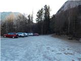
From the highway Ljubljana - Jesenice, we take the Ljubelj exit and follow the road ahead to the border crossing. Just a few meters before the border crossing, signs for Zelenica direct us to the left and after some 10 meters of additional driving, the road brings us to the parking lot below the ski center Zelenica.
Route description:
At the end of the large macadam parking lot, we will notice a wooden mountain sign with the inscription "planina Preval", which directs us into the forest on a footpath that quickly brings us to the foot of the scree slopes. Here we arrive at a smaller junction, where on the rock we will notice the inscription Prevala and Roblekov dom to the left. The gentle path then quickly moves from the scree into dense forest, which is exposed to falling rocks. The wide path then transitions from the forest onto steep and well-protected slopes. The panoramic path then brings us to Born's tunnel, where a headlamp will be helpful. When passing through the tunnel, be careful due to the larger number of puddles and the occasionally low ceiling. On the other side of the tunnel, we continue for some time on the path nicely routed along the eastern walls of Begunjščica, then transition to scree, which we only cross. This is followed by a shorter crossing of steep forested slopes, after which the path begins to ascend gently on a less steep slope. The still wide path, which ascends only moderately, joins higher up the marked path from Podljubelj.
Here we continue right and follow the wide path to the mountain pasture Preval, which we reach after a few minutes of further walking.
From the cross at Preval, we continue north on the marked footpath toward Begunjščica via Kalvarija (left to Roblekov dom via Roža, right to Ljubelj and Podljubelj). The path ahead first ascends over a panoramic grassy slope, then enters the forest through which it begins to ascend more steeply. Higher up, the forest starts to thin, and the path becomes somewhat steeper. This is followed by a fairly steep ascent, which first runs through some belts of dwarf pines, and higher over steep grassy slopes that are especially dangerous for slipping when wet. We then cross a slightly exposed gully where a small memorial plaque is placed, and the path ascends for a few more minutes along the steep grassy slope. When the slope a bit higher flattens slightly, the marked path turns left and crosses the slopes to the left. Just a few minutes further, we arrive in a small valley where the slope flattens even more. We only cross the mentioned valley (slightly right of the valley, we can ascend to Begunjska Vrtača in 15 minutes via easier pathless terrain), then in a few minutes we climb to the main ridge of Begunjščica. When we step onto the ridge, a nice view also opens to the north, and we continue along the gentle path that proceeds along the somewhat narrower ridge. This is followed by a short descent to a small saddle, where the "path" via Šentanski plaz joins from the right. Here the ridge of Begunjščica widens, and we follow the increasingly panoramic path to the subpeak of Veliki vrh. Another very short descent follows, then without major difficulties we ascend in a few minutes to the highest summit of Begunjščica.
Ljubelj - Preval 1:30, Preval - Begunjščica 2:00.
The path to the mountain pasture Preval is unmarked, further on it is well marked.

Photos:
 1
1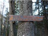 2
2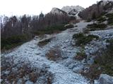 3
3 4
4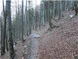 5
5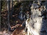 6
6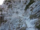 7
7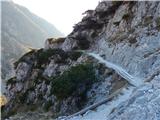 8
8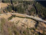 9
9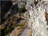 10
10 11
11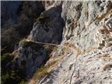 12
12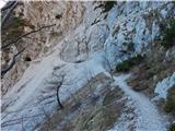 13
13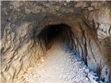 14
14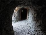 15
15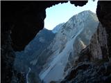 16
16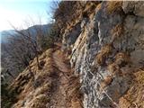 17
17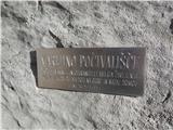 18
18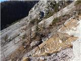 19
19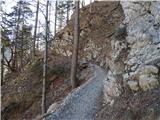 20
20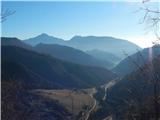 21
21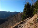 22
22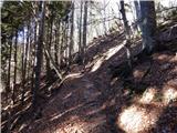 23
23 24
24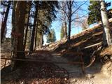 25
25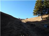 26
26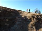 27
27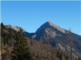 28
28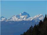 29
29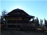 30
30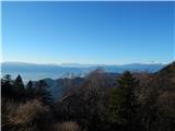 31
31 32
32 33
33 34
34 35
35 36
36 37
37 38
38 39
39 40
40 41
41 42
42 43
43 44
44 45
45 46
46 47
47 48
48 49
49 50
50 51
51 52
52 53
53 54
54 55
55 56
56 57
57 58
58 59
59 60
60 61
61 62
62 63
63 64
64 65
65 66
66
Discussion about the trip Ljubelj - Begunjščica (via Preval)
Show older messages
|
| martinP22. 04. 2007 |
To Preval there is no significant ascent, then a fairly steep ascent awaits over Kalvarija. We planned to descend via Zelenica but there was still quite a lot of snow on the other side, so we went to Roblekova koča and back via Roža to Preval and to Ljubelj.
Great trip.
|
|
|
|
| Gost29. 05. 2007 |
still snow up there??? (I'd say no)
|
|
|
|
| Gost7. 10. 2007 |
Ljubelj - Preval:
The path from Ljubelj to Preval was wonderful, scenic, so to speak without notable ascents or descents, almost constant at around 1250 m altitude. Exposed areas were well secured. From time to time I got a bit squeezed, as I watched a group of children in front of me pushing through the narrow and precipitous path. Fortunately, everything turned out well. The winding narrow path through the steep slopes of Begunjščica seemed fairy-tale like at times. Even little Julija forgot that her legs hurt and that she was sleepy. Hand in hand, we cheerfully let the path lead us. On open and exposed bends, there was a slight breeze. Deep below, the Šentanska dolina was still slumbering, along which the asphalt road to Ljubelj pass wound, and along which isolated farms were colorfully shining in the morning sun. From the right, the high scree of Zajmehovih peči greeted us for a good part of the path across the valley. In the background, I sensed Veliki vrh and below it the frequently visited Kofce. One of the exciting sections of the path was the Bornov tunnel, at least for the children. There was quite a lot of water in the tunnel, as it had rained the day before. Headlamps were very useful. Since we were walking in a group, we cast shadows on each other's path, so I waded well into the water a few times. Nothing serious. All this is the specificity of this beautiful path. Most of it was already covered with beech and maple leaves this time. Wonderful.
|
|
|
|
| Gost8. 10. 2007 |
This trip is even nicer when the planina is alive and the hut is open. Friendly hut and excellent food, and for children the cows on pasture are interesting. They can also "go wild" around the hut, as the terrain is not exposed.
|
|
|
|
| Gost8. 10. 2007 |
In the mountain hut at Preval I also liked that they even have chickens up there roaming freely, so you can be sure everything is made from really fresh "farm" eggs. And the cheese loaves they make are great too! And the cheese loaves they make are great too!
|
|
|
|
| Gost12. 10. 2007 |
The path from Preval to the summit is very steep, so I recommend poles. It's also good to have a flashlight for the Bornov tunnel. Lp Hribolazec
|
|
|
|
| Taurus16. 10. 2007 |
On 13 and 14/10-07 the Koča na Pl. Preval was closed despite the exceptional attendance and no trace of any domestic animals - a pity, probably ending the season. But there were quite a few hiking pigs (bottles) - I collected them in my backpack. 
|
|
|
|
| Gost20. 10. 2007 |
Dear people, when have you last seen mountain pastures (which the hut at Preval is) open in mid-October? They drive the livestock down to the valley at the latest by mid-September from all pastures!!!
|
|
|
|
| majdicst11. 08. 2008 |
In my opinion one of the most interesting trails in our mountains. We did it downhill on the way back from the summit. It offers everything you can expect from such a not too difficult but picturesque trail: comfortable walk through the forest, some exposed spots that are well secured, exceptional views of the valley below, crossing scree and something not very common - a tunnel about 200m long. In the tunnel it's highly highly recommended to have a light, as some places are under water, logs and stones lie around to help not step in puddles, but you can slip on them and fall into the wet element.
The trail from Begunjščica via Kalvarija is really steep and due to rain in previous days it was also appropriately slippery. Probably you don't spend much more time on the ascent than on the descent.
There were many visitors at Preval (especially families with children), sour milk is excellent.
Ascent via Zelenica and return via Preval - recommended circular tour where you get to know Begunjščica from both sides.
|
|
|
|
| Biser gora11. 08. 2008 |
The path is beautiful, but if you start the hike too late, the sun can really burn.
|
|
|
|
| NEIC00824. 08. 2008 |
Did this trip today.. I'm wondering why the path is marked here as ''demanding path'' since I didn't see or experience anything demanding anywhere..??? I recommend it also for Sunday hikers (at least to Preval).
|
|
|
|
| Bojan_A24. 08. 2008 |
The path is demanding because safety gear (wire rope) appears on it. I know people (with vertigo) who have already turned back on the path through Bornov tunnel. This path isn't for everyone either.
For an average mountaineer, it's a highway - bikeable.
4 days ago I ran to Begunjščica from this side. Starting in Draga and running to Preval via Luknja. Running over Kalvarija is just steep enough. No panic. The problem for me was then along the ridge to Veliki vrh where my road shoes had no grip on the smooth rocks. Descent to Roblek was also awkward. Stol is much safer for running.
|
|
|
|
| Bojan_A2. 09. 2008 |
Yesterday I ran this tour again. On the first school day I didn't expect crowds, but I met a whole crowd of hikers. It's great for running on the Bornova path because it's flat for warming up. Over Kalvarija it's then real mountain running. Running on the summit ridge is quite awkward. I descended to the north side via Zelenica. The mighty Smokuški plaz particularly caught my interest, which I traversed this winter.
|
|
|
|
| naša18. 09. 2008 |
Last time I was at Preval (via Zelenica and over Begunjščica) I saw a small path towards the top starting exactly behind the cableway and signs at Preval - it looks like it goes directly to the summit. Does anyone know this path? It seemed very attractive to me. By the way they have great štrukeljci at Preval. And no such noise as at Roblek where you can listen to folk music hits on outdoor speakers 
|
|
|
|
| vesnica18. 09. 2008 |
This path is called via calvary and you get directly to Begunjščica.
|
|
|
|
| NEIC00818. 09. 2008 |
Calvary. The path is fairly steep and runs through forest then over the ridge of Begunjščica where there is slight slipping risk when wet but overall easy tour.
The only major obstacle on the path are sheep..
|
|
|
|
| naša18. 09. 2008 |
Oh thanks for the information. I'll go next time via calvary. Good luck to you!
|
|
|
|
| naša18. 09. 2008 |
Aha and also: at the top of Begunjščica right under the little tower lives a pretty grey mouse. It has an underground home with two entrances. Cute :-)
|
|
|
|
| andymann18. 09. 2008 |
but it really is calvary via calvary.
really steep!
|
|
|
|
| mstrman24. 07. 2009 |
Today I went on this path through Bornov tunnel to Preval, then via the via crucis to Begunjščica (quite demanding path - really a via crucis) along the ridge to the main summit - Begunjščica 2064m, down to Roblekov dom, then to Zavirska planina past the hut in Zavirska planina to Zelenica and back down to Ljubelj. The path apart from the via crucis is not very demanding, but requires quite some fitness, the tour with short stops in huts is all-day, I started at 7am from Ljubelj and returned at 5pm back to Ljubelj.
|
|
|
|
| štempilka4. 07. 2009 |
This is a very nice tour, but I went the other way, via Zelenica to the top then to Roblek, then back via Roža to planina Prevala and back to Ljubelj. Very nice, in this direction it's not so strenuous at all.
|
|
|
|
| BraJan11. 07. 2009 |
Today I went again from Ljubelj to Preval and then via Kalvarija to the summit of Begunjščica, from there down the north side past the hut at Zelenica to Ljubelj. I think this is one of the nicest trails in the Karavanke. I walked the trail in less than five hours, although I hike slowly. Perhaps the section via Kalvarija is more strenuous, but overall the tour is undemanding and I recommend it to all who want to gather positive energy and feel pleasantly tired back in the valley.
|
|
|
|
| Leon8112. 08. 2009 |
To pose the question here too, where the discussion is a bit more up-to-date. Which variant do you recommend: up via Prevalo and down via Zelenica or vice versa?
Best, Leon
|
|
|
|
| nata2412. 08. 2009 |
Up via Zelenica (via Prevalo it drags) and down via Šentanski plaz. Best
|
|
|
|
| aleš4328. 09. 2009 |
It seems to me better to go via Preval-o, because you just warm up and prepare for the path over Kalvarija, which really is a Calvary. The path is full of sheep, shit-covered trail, you have to watch where you step, you'll grab...
At the top of Kalvarija, under the meadow slope of Begunjščica (near the memorial plaque) right before my eyes a sheep flew into the abyss down the scree . No help for it! God the shepherd.
I returned via Zelenica and to me it's better that way. Extremely beautiful, picturesque circular path!
Otherwise there wasn't the best view this weekend, but in the mountains it's always nice!
|
|
|
|
| janez4813. 06. 2010 |
Next Sunday I plan to go to Begunjščica via Preval. I'm curious what the uphill path is like, especially if there's still any snow.
|
|
|
|
| nata2413. 06. 2010 |
Yesterday I went on this path and there's no snow left. But the sheep towards the top have already done their business (droppings everywhere).
|
|
|
|
| janav13. 06. 2010 |
Today, like many others, I went to Veliki Vrh (Begunjščice). The calvary takes its toll, but the view makes up for everything. But can someone explain how hikers (who?) leave trash right at the summit (an empty plastic bottle and an (empty) can of fish went down to the valley with me), but unfortunately I couldn't reach the banana peel because someone threw it onto a pine above the precipice. Let me emphasize that even a banana peel belongs in the backpack and down to the valley (even though it's organic). HIKERS, LET'S PROTECT NATURE!!!
|
|
|
|
| VanSims12. 09. 2010 |
The trail from Preval through the forest is quite steep and the markings are sparse like in Gorenci (since we're on the topic ), even though the path is supposedly obvious. When exiting the forest, you occasionally need to scramble a bit on some rocks (easy). The final ridge can be a bit dangerous when wet.
For descent, in my opinion, it's not a very pleasant trail.
|
|
|
|
| fpetel112. 09. 2010 |
Via Kalvarija it's a very steep trail that requires solid fitness. Below the ridge, we scramble twice a bit. My subjective opinion (maybe others disagree) is that this trail is more demanding than the one from Zelenica direction. The summit part from Roblek is completely easy in dry conditions, as it's mostly reinforced with logs.
Best, Franci
|
|
|
|
| VanSims13. 09. 2010 |
I agree, fptel1. It would be interesting to know how the author would rate this trail in terms of difficulty if taking the road ascent to Preval as starting point (easy trail).
From Roblek it is indeed less demanding, except a couple of meters below the summit (I descended it).
|
|
|
|
| skalar5013. 09. 2010 |
Begunjščica and neighboring Vratača are sort of my "home mountains" - Descent via Kalvarija in rain (greater moisture) really isn't the most "pleasant" (steepness), then preferable to Roblek - summit - back to Roblek then Rožca - Preval - Ljubelj plateau.
The trail from Roblek to the summit, since it's obviously been repaired, is easier, as VanSims also notes...
Yes, the upper edges of the Begunjščica massif as pasture are "dominated" by sheep, therefore...
|
|
|
|
| damijanp13. 09. 2010 |
Yesterday we did a circular route: Ljubelj-Zelenica-Begunjščica-Roblek-Roža-Preval-Ljubelj. The path is beautiful, only the crowd was yesterday, as probably everywhere, quite large. The sheep were probably in the minority.
Photos are at:
Begunjščica
|
|
|
|
| ceko24. 02. 2011 |
here I was up there today, weather super but a bit too windy. There's still quite a bit of snow but no living soul anywhere. The only thing I encountered was one chamois
|
|
|
|
| matic425. 02. 2011 |
ceko, did you go along the path described above? Can you tell more about the snow conditions on the path?
|
|
|
|
| Damien_832. 05. 2011 |
Yesterday evening I did a nice tour. Ljubelj, Prevala, ascent to Begunjščica, descent to Roblekov dom (tea, bean stew with sausage, it was good) and home The forest path to Beg. is soggy, here and there a bit of mud, but no big deal, it was walkable. At the top just enough snow to dirty someone As for the weather, they forecasted who knows what storms, but just the opposite 'sunshine' except when descending from Roblekov dom, rain and mini hail caught me for 5 min. It was nice! Regards Damjan
|
|
|
|
| Cetus16. 05. 2011 |
I'm thinking of setting off on Saturday on the circular path Ljubelj-Zelenica-Begunjščica-Roblek-Roža-Preval-Ljubelj. But I'm wondering about falling rocks and if you use a helmet for this path.
lp
|
|
|
|
| Bojan_A16. 05. 2011 |
Anyway, if you're one of the taller ones, a helmet doesn't hurt in the Born tunnel.
|
|
|
|
| bats17. 05. 2011 |
Very nice tour, I did it last year in the opposite direction. Beware of falling rocks under every wall, Begunjščica is no exception. Last year there was still snow in June, so you can expect some on the S side. For the tunnels, a battery is even more useful.
|
|
|
|
| Matjaz_654. 09. 2011 |
a few more of my pics ... with ascent via Smokuška planina and Roblek ... and descent via Preval and through Bornov tunnel
|
|
|
|
| petruša10. 09. 2011 |
Hello, we plan to go to Begunjščica next weekend. We'd make a circular path, so which one is better? Is it good if we first go up through Bornov tunel and Prevala. Then we'd go down via Roblekov dom and Zelenica. We'd pass the hut for stamps so the kids get the transverzale stamp. Please for opinion and if it's marked. Thanks in advance and lp.
|
|
|
|
| pelican10. 09. 2011 |
Personally I preferred going back via Bornove, because it's easier and almost flat and towards the end after a few hours of walking such a path is quite welcome...
|
|
|
|
| otiv10. 09. 2011 |
@petruša
I don't know the ages of your children, maybe it'll be quite long for kids. But it's best to go up past planina Prevala and then towards the top of Begunjščica.
|
|
|
|
| JusAvgustin10. 09. 2011 |
Draga-Prevala via Luknja-Begunjščica via calvary-Roblekov dom under Begunjščica-Poljška planina and back to Draga. Beautiful circular path, but Zelenica is skipped. It's marked, was there on Wednesday
|
|
|
|
| petruša11. 09. 2011 |
No problem for kids, they are 12 and 11 years old, have more stamina than me and my husband. They have already walked quite long routes. This year they hiked Triglav up and down in one day, so time is no issue. I was just interested where it's better to go up and where down to make a circular path. To see and admire more than if going up and down the same path. It's also a pleasure, but if a circular tour is possible why not. cheers
|
|
|
|
| uhan129. 09. 2011 |
Hello
I'm interested in how long the circular tour Ljubelj-Bornovi tuneli-Prevala-Begunjščica-Roblekov dom-Zelenica-Ljubelj takes? Thanks
|
|
|
|
| petruša29. 09. 2011 |
Hello @uhan1
We did the circular tour on 17.9.2011: Ljubelj- through Bornov tunnel-Prevala- Begunjščica via calvary- down to Roblek (had three-quarters of an hour break there)- back up and to Zelenica- Ljubelj. We started from Ljubelj at 7:55 in the morning, returned at 16:35. You have to count that there were also two children 11 and 12 years old. We walked at a leisurely pace, had several breaks and took quite a few photos, because you get delayed by photographing. We had a nice day and a nice tour. Take advantage of the nice weather and do this circular path. lp
|
|
|
|
| uhan129. 09. 2011 |
Thanks!!
|
|
|
|
| Lunatic30. 09. 2011 |
Hello!
Is the path to the saddle suitable for a 4.5-year-old daughter , who is otherwise an excellent hiker. For the dog there probably wouldn't be any problems? , who is otherwise an excellent hiker. For the dog there probably wouldn't be any problems?
Best regards.
|
|
|
|
| GregorC30. 09. 2011 |
Of course he's a lunatic. The path isn't difficult, but a bit of caution is needed, just like everywhere.
|
|
|
|
| Enka30. 09. 2011 |
The path to Preval is suitable for children and dogs. Of course, the child needs to be supervised on sections where the path (which is otherwise more than wide enough) is a bit exposed. But really no problem.
|
|
|
|
| Lunatic30. 09. 2011 |
To both, thanks for the info We're going to check it out tomorrow...
Regards.
|
|
|
|
| Enka30. 09. 2011 |
Oh, and wear appropriate footwear. There's real water in the tunnels, and the stones might be a bit too far apart for children's steps. So shoes that won't get soaked right away are good. And headlamps, essential!
|
|
|
|
| Nuši28. 11. 2011 |
Considering that yesterday the weather was gorgeous and that probably quite a few hikers went to the Julijce mountains, we headed to Begunjščica. We left the car at the lower cable car station below Zelenica and headed along the path through the Bornova tunnels towards planina Prevala. Then over Kalvarija towards the summit. The path is really steep and you really "gnaw your knees". Once you get above the tree line, the view is gorgeous. And then cheerfully towards the top. And when you think you're actually at the top, you still have to go a bit up and down to finally reach the goal. However, the effort was rewarded, as the view from the top was gorgeous in all directions. And no crowds at all, so you could really enjoy the blue sky and the wonderful views of the surrounding peaks. Since we were already quite late, we chose the path over the scree towards the middle cable car station at Zelenica for the return. Since I had never hiked over scree, I was a bit scared. The first steps were uncertain and a bit fearful, but once I realized it's not that bad and you mainly have to watch to walk on your heels, it became a pleasure and I was actually sorry that the scree was already over. Then descent along the road under the cable car and in the dark to the car. And one last look at the surrounding peaks. The peaks were still illuminated by the sun and a star was already shining above Veliki vrh. Gorgeous day!
|
|
|
|
| @rekar1. 01. 2012 |
If you are planning a trip to Begunjščica or to Roblekov dom from the Ljubelj direction, I must inform you that the hut at Preval is open.
|
|
|
|
| jax892. 04. 2012 |
Today I did my first "tour" I started from Begunje and headed to Dobrča. Then I continued towards Preval and onwards via Kalvarija to Begunjščica. Since I'm not brilliantly fit, it took me 1.5h to the top and to be honest I really struggled to the summit But it's a nice path with wonderful views. I continued the path to Roblekov dom and then descent to Draga For me the tour was quite strenuous, but I'll repeat it. All huts were closed (probably open only on weekends)
|
|
|
|
| vesnapl3. 04. 2012 |
Is there any snow on the path from Preval via Kalvarija to the summit of Begunjščica and from the summit to Roblek?
|
|
|
|
| nusa3. 04. 2012 |
I also walked this path yesterday. The path is dry. It was nice.
|
|
|
|
| vesnapl3. 04. 2012 |
Thanks! I can hardly wait to walk it myself.
|
|
|
|
| velkavrh4. 04. 2012 |
My second path this year in Karavanke will be this one. Last year I went from Zelenica and back via Roblek, Draga, Soteska to Preval and Bornov tunel to the car.
|
|
|
|
| katty4. 04. 2012 |
How long does this path take? I'm collecting variants on which path to climb to Begunjščica, to see as much as possible.
|
|
|
|
| Lunatic5. 04. 2012 |
Ljubelj - Prevala approx. 1h, then to the top via Kalvarija another good 1h, then towards Roblek and before right to Zelenica another approx. 1h... if I haven't forgotten already... Best regards.
|
|
|
|
| rjudnic5. 04. 2012 |
A couple of years ago I went with friends from Ljubelj via Prevala and Kalvarija to the top and back to the car via Zelenica. Very nice circular trail that with stops takes less than 8 hours. If you go past Roblek it's another good half hour longer.
|
|
|
|
| mgrego2210. 04. 2012 |
My husband and I often do a circular route namely start from Ljubelj first to Zelenica (45 min), from Zelenica to Roblekov dom (50 min), from Roblekov dom to planina Preval (50 min). On planina Preval obligatory strengthening with the best štruklji. From Preval then through Bornov tunel to Ljubelj. We've done this several times but often add more: either from Zelenica also to koča na Završnici or from Zelenica first to Begunjščica then to Roblek. Once we also went from Roblekov dom to Poljska planina and from there to Preval. In short lots of options for nice circular paths with lots of views.
|
|
|
|
| Ružica16. 07. 2012 |
Born's tunnel has been nicely cleaned this year and there was very little water in it. We did a nice tour from Ljubelj to Preval and along the calvary ridge to the top of Begunjščica, descent to Roblek and the hut at the source of Završnica. Nice tour for our 17 from
Zagreb.
|
|
|
|
| planinka eva10. 08. 2012 |
I went from Ljubelj to Stol then slept at Zelenica, the next day to Roblekov dom and Begunjščica, back via Preval to Ljubelj really super route!
|
|
|
|
| l.tana10. 06. 2013 |
Hello,
this weekend we plan to do the circular route Ljubelj-Prevala-Begunjščica-Zelenica-Ljubelj. Do we need to bring a helmet?
|
|
|
|
| petruša10. 06. 2013 |
We did this two years ago, with us went children aged 10 and 12 and we didn't have helmets, I think it's not necessary on this path... best regards
|
|
|
|
| mukica10. 06. 2013 |
perhaps there is still some snow in the gullies on the Begunjščica - Zelenica path, it would be good to check..
|
|
|
|
| Alesko197111. 06. 2013 |
In gullies stones slide down the slope with snow in winter. When the snow melts, stones or rocks lose support... It won't hurt to wear helmets for the descent from the top towards Zelenica (I assume it's crossing the Smokuško scree) ... Half a kilo up or down in the backpack
|
|
|
|
| urbmic11. 06. 2013 |
I walked exactly this tour on Saturday. Almost no snow left. I didn't have a helmet with me.
|
|
|
|
| l.tana12. 06. 2013 |
Thanks for the information.
|
|
|
|
| cebelca12. 06. 2013 |
Are the sheep already up there?
|
|
|
|
| urbmic13. 06. 2013 |
Of course, just so you don't have to count them
|
|
|
|
| mpurg26. 07. 2013 |
On Sunday I plan a circular route Ljubelj-Preval-Begunjščica-Zelenica. Since it will be very hot, I'm interested if there will be any shade on the descent or would it be better in the opposite direction? thanks
|
|
|
|
| Daaam26. 07. 2013 |
there's more shade (forest) in the direction Preval-Begunjščica, so decide for yourself when you'll use it. Either up or down
|
|
|
|
| otiv26. 07. 2013 |
In jest I'd say it's best to stay in the Borna tunnels, where the temperature is still bearable no special difference to expect, so it doesn't matter how you'll do the tour. When it's hot, it's hot everywhere.
Good luck!
|
|
|
|
| marezt26. 07. 2013 |
Still it would be better Ljubelj-Zelenica-Begunjščica-Preval-Ljubelj! Because in the morning when going up it's not so hot yet... on the way back a bit of shade and breeze in the tunnels comes in handy ...definitely a very nice trail in both directions! Good luck!
|
|
|
|
| mpurg27. 07. 2013 |
thanks everyone I'll set off early, so I'll have shade on the return....I'll use the tunnels on the way back
|
|
|
|
| Janiel746. 06. 2014 |
Maybe someone knows if there is still any snow on this trail?
|
|
|
|
| @rekar6. 06. 2014 |
There is no more snow, maybe some patch on the northern side of Begunjščica, towards Zelenica
|
|
|
|
| Janiel746. 06. 2014 |
So the Ljubelj - Zelenica trail and up to Begunjščica are dry too? But I don't mean Šentanski...?
|
|
|
|
| Edina13. 06. 2014 |
Yesterday I finally walked the path through the Born tunnels and climbed to Veliki vrh from Preval, already the third in a few days. I returned via the northern slopes of Begunjščica and via Zelenica to Ljubelj. Beautiful circular tour; the path through the tunnels to Preval for the first time ever, return via Zelenica the first repetition after thirty-five years. Happy trails, more on the blog
http://stezeinsledi.blogspot.com/2014/06/in-se-tretji-veliki-vrh-tokrat-v-masivu.html
|
|
|
|
| smatjaz15. 06. 2014 |
Today finally managed the tour Ljubelj - Bornovi tuneli - koča na Prevali - via Kalvarija to veliki Vrh - Roblekov dom - via SPP to Zelenice - Ljubelj. Path fully passable and partially demanding. Approx. 8 hours walking.
|
|
|
|
| nincokl11. 08. 2014 |
I did the tour to Begunjščica a bit differently, namely Ljubelj - koča na starem prehodu Ljubelj - Polni vrh - Ljubeljščica - Zelenica - Begunjščica - Roblekov dom - čez Rožo na Preval and through Bornov tunel back to Ljubelj. With all stops I took 11 hours for this wonderful circular route.
|
|
|
|
| Ajda_Zitnik6. 07. 2015 |
Yesterday I walked the path Ljubelj-SPP-Veliki vrh in Begunjščica-Preval-Ljubelj; so I descended from Veliki vrh via this path. My only comment on this description is that I wouldn't mark the path from the summit down as well marked, as in my opinion, some additional marks wouldn't hurt in places.
|
|
|
|
| gorjanci3. 08. 2015 |
Next Sunday I'm setting off on this trail. Wondering if it's suitable (technically) for a dog that's used to mountains ....
|
|
|
|
| malimiha3. 08. 2015 |
It's suitable. Verified. Best Miha
|
|
|
|
| pemi3. 08. 2015 |
it's suitable, I went alone with my little dog without problems.. just if you plan to return to Zelenica there's a slightly more "demanding" section in between, but it's one meter, as far as I remember
|
|
|
|
| natalia2322. 10. 2015 |
Hello hikers, does anyone perhaps know what the conditions are like on this path towards the summit, because tomorrow 23.10.2015 I intend to hike this tour?
|
|
|
|
| skalar5011. 08. 2016 |
... last weekend (already) classic jam in these time slots ... with family this time after many years stopped again at Prevala mountain hut ... never again! not even a jot of yogurt .. WC so dirty it's really hard to believe ...
|
|
|
|
| Jusk19. 09. 2019 |
This afternoon went from Ljubelj to Begunjščica, interesting path through Bornov tunel, need to watch your head path over Kalvarija nicely steep, towards the top also quite slippery. Views poorer due to clouds at the top. Return via Roblek to Preval and back to Ljubelj
|
|
|
|
| Planinecizgg19. 11. 2019 |
Hello!
How is this trail if there's snow on it? Are crampons and ice axe mandatory?
Best regards.
|
|
|
|
| Jusk19. 11. 2019 |
I'd say yes, the path from Preval onwards is really steep. Lp
|
|
|
|
| Perosu124. 06. 2020 |
Yesterday, 23.6 glasses found below the summit - they are at Kompas on Ljubelj
|
|
|
|
| Lapuh20713. 06. 2021 08:42:36 |
Has anyone been up this side recently?
|
|
|
|
| Janez Seliškar13. 06. 2021 12:26:58 |
Yesterday they also went to Begunjščica via Kalvarija. No winter gear was needed.
|
|
|
|
| primozg4. 08. 2022 07:07:16 |
On Sunday 31.7. up this trail to Begunjščica. From Roblek I went towards Tinčkova koča and then turned towards Zelenica. Nice trail, but steep and slippery when wet. More photos and description at https://gorskimoz.si/2022/08/04/begunjscica/
|
|
|
|
| Tomaž0022. 08. 2022 07:57:38 |
Is the path through the tunnel normally passable, thanks for the kind replies
|
|
|
|
| Loni22. 08. 2022 08:30:24 |
About a month ago the tunnel entrance was still quite clogged, but one could crawl through. It's also evident from Primož's photo descriptions.
|
|
|
|
| lubadar22. 08. 2022 09:27:24 |
The tunnel entrance is cleared, passed through yesterday.
|
|
|
|
| seinfeld29. 10. 2022 17:32:36 |
Today first time on Begunjščica. Tunnel entrance cleared, even some water dripping, quite a lot of leaves on the path. This path is by no means easy, has quite a few exposed spots, some easy climbing, but above all requires excellent fitness. Back via Zelenica, very slippery in a few lower sections. Weather divine, plenty of hikers, even more cars.
|
|
|
To post a comment you must log in:
If you do not yet have a username, you must first
register.