Koncentracijsko taborišče - Planina Korošica (hunting path)
Starting point: Koncentracijsko taborišče (1000 m)
| Latitude/Longitude: | 46,4334°N 14,2707°E |
| |
Route name: hunting path
Walking time: 1 h 30 min
Difficulty: easy unmarked way
Elevation gain: 554 m
Elevation difference along the route: 575 m
Map: Karavanke - osrednji del 1:50.000
Recommended equipment (summer):
Recommended equipment (winter): ice axe, crampons
Views: 54.240
 | 1 person like this post |
Access to starting point:
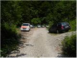
From the Ljubljana–Jesenice highway, at the Podtabor junction we continue in the direction of Ljubelj and Tržič. We continue driving on an initially fast, then regional road in the direction of Ljubelj. At the last left turn on the Slovenian side, which is located approximately 500 meters behind the concentration camp, we turn right onto a macadam road, which we follow for less than 100 meters to a somewhat larger macadam parking lot.
Route description:
From the parking lot, we continue on a poorer macadam road, which ends already after a few minutes by the nearby torrent. Here signs for Planina Korošica direct us to the right onto a well-maintained old border guard or hunting path. We continue the ascent in numerous serpentines on the footpath, which ascends relatively steeply through the forest. Higher we reach a viewpoint, the path turns left there and then ascends moderately to steeply for some time. Higher we step onto a cart track, which we follow for only some 10 m, then at a smaller junction we leave it and continue straight ahead. The path immediately returns to the forest, and we continue ascending on a pleasant forest footpath, which a little further brings us to a smaller junction, where a worse-beaten footpath branches off to the left, and we continue sharply right. The path then flattens and brings us out of the forest onto grazing slopes. The path continues by traversing the slopes to the right and a little further brings us to a marked junction.
We continue slightly right (sharply left Koča na Ljubelju and Košutica) and continue on a wide and gentle footpath, on which in approximately 10 minutes of further walking we arrive at the shepherd's hut on Planina Korošica.

Photos:
 1
1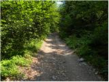 2
2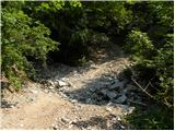 3
3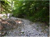 4
4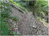 5
5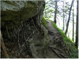 6
6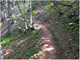 7
7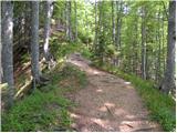 8
8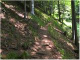 9
9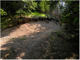 10
10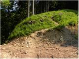 11
11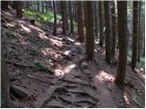 12
12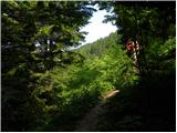 13
13 14
14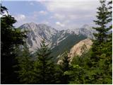 15
15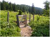 16
16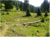 17
17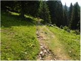 18
18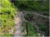 19
19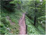 20
20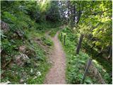 21
21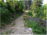 22
22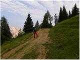 23
23 24
24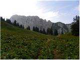 25
25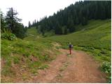 26
26 27
27
Discussion about the trip Koncentracijsko taborišče - Planina Korošica (hunting path)
|
| m.b.29. 05. 2011 |
Beautiful trip, although some snow has fallen. The hut is open and the caretakers provided the first sour milk.
|
|
|
|
| m.b.29. 05. 2011 |
At the hut we met PD Ivanec from Croatia.. pleasant company and best regards from D and M.
|
|
|
|
| mgrego2215. 04. 2012 |
I'm wondering if the hut is already open on weekends now? Is the trail okay or is there still any snow?
|
|
|
|
| @rekar17. 04. 2012 |
As far as I know, the hut is not yet open, but the path is dry from all sides. On weekends, Planina Preval, planina Planinca and the hut on Poljska planina are open.
|
|
|
|
| velkavrh13. 10. 2012 |
Today I went up this path. The path is fine. It is indeed muddy and you have to be careful because of slips. At the planšarija on Planina Korošica, chickens greeted me. The planšarija was open, which pleasantly surprised me. Down I went along the usual marked path. Shortly below the planšarija, I met a tractor driver pulling beech logs. I soon saw what that meant. He literally turned the road into muddy mush that sank to the ankles. I didn't go back that way, and I was very sorry because I was muddy even on my windbreaker. Down at the little bridge by the stream there is indeed a sign that the road is closed due to timber extraction. There is no such notice at the planšarija, nor at the parking lot below where this path starts. So I advise against the marked path.
|
|
|
|
| amarilis15. 10. 2012 |
Our somewhat smaller hiking group also unanimously decided to visit Planina Korošica. On the return from the planina, we jointly decided to avoid the muddy road. Along the parallel pathless route, without the unnecessary road mud, we reached our iron horses, which we had parked even further from the marked parking lot. In the end, we were all very satisfied. Best regards.
|
|
|
|
| velkavrh15. 10. 2012 |
Unfortunately, I don't know the parallel pathless route, but I would like to know it. I did look around a bit to avoid the road, but I didn't notice any pathless route. The pathless route hasn't been mentioned until now either.
|
|
|
|
| lynx15. 10. 2012 |
Off-trail is everywhere where there is no path. You can spot some unmarked trails at most, torrents and steep slopes.
|
|
|
|
| mgrego2215. 06. 2013 |
Has anyone been to Korošica recently? The hut is probably already open on weekends? How is the path? It must be really pleasant now. 
|
|
|
|
| _sandra_16. 06. 2013 |
I was at Korošica yesterday, just not from this starting point.. the hut is open;
|
|
|
|
| marezt19. 06. 2013 |
From this mountain pasture there should be a path to Košutica... Maybe someone who has already walked this path can describe it?
Best regards
|
|
|
|
| mgrego2231. 05. 2014 |
How's it on Korošica, is the hunting path okay due to ice damage?
|
|
|
|
| AdryBK23. 09. 2014 |
Hi, does anyone know until when (date-wise) the hut on Planina Korošica is open? Thanks
|
|
|
|
| cvetlica8924. 09. 2014 |
Last weekend they drove the livestock away, on Monday only the owner was left on the pasture, who is returning to the valley this week.
|
|
|
|
| skalar509. 08. 2015 |
this afternoon a thunderstorm with hail thoroughly softened the "hunter's path" ... the torrent carried away rocks, chunks of logs ... it was impassable for quite some time ... before that a hot summer sunny day, with pleasant coolness at the mountain dairy
|
|
|
|
| Ljubljana29. 10. 2015 |
Will the hut be open during the holidays (31.10. and 1.11.)?
|
|
|
|
| lucylucy6. 06. 2016 |
I also visited this mountain pasture. The trail is easy and not strenuous, but very poorly marked. The hut owners are friendly and accommodating.
|
|
|
|
| keti18. 06. 2016 |
Is the hut already open? Have they already driven the livestock up?
|
|
|
|
| Lepi čeveljc2. 08. 2016 |
Planina Korošica is super! It still remains as it was years ago (no cars and no excessive crowds). The food is tasty. The caretakers are very friendly. Nice outing. Highly recommend.
|
|
|
|
| madeira1. 05. 2020 |
Today after many years to Korošica. In the forest several new logging roads or tracks have been made. The path section shown in pictures 11 and 12 is now different and the trail is barely findable. After switchbacks reaching the first (rutted) logging road go right. Shortly the logging road forks and go left, after a few meters turn right into the forest on the trail. At both key points someone tied red tape to the trees.
|
|
|
To post a comment you must log in:
If you do not yet have a username, you must first
register.