Hiking-trail.net
hiking-trail.net
Login
Login
Username:
Password:
Login
Not registered yet? Registration.
Forgot password?
      

Tosc

Print
mavi121. 06. 2025 14:52:10
Has anyone been to Tosc in the last few days? Is the path to Tosc from Rudno polje already completely dry?
Thanks for the help smile
like
cofka1. 06. 2025 16:31:15
The path is dry.
(+1)like
mavi121. 06. 2025 17:03:32
Great, thanks for the info smile Yesterday from Viševnik I saw some snow patches left and that's why I checked. So that snow is off the path.
like
asdf1. 06. 2025 17:19:14
On the path to Studorski preval there are still some snow patches, which are not problematic and could all be bypassed if one wanted. Further on, I don't know.
(+1)like
mavi121. 06. 2025 17:30:19
Aha thanks. The main thing where I'm worried about snow is exactly from Studorski preval onwards and especially on the slope of Tosc.
like
Tomco1. 06. 2025 18:19:35
mavi12,

from Studorski preval on the "magistral" path onwards towards Tosc it was all dry already two weeks ago, also the southern slopes of Tosc were already almost completely snow-free. At least to the bend, which was visible from Ablanca. Here's a fresh pic, check the last post from Todi:
https://www.hribi.net/trenutne_razmere/slo/visevnik_mali_in_veliki_draski_vrh_ablanca/1/1982
All dry. Just go. nasmeh
(+1)like
VelikiZajetnež1. 06. 2025 18:24:40
No problem, you can do it, safe path velik nasmeh

Srenjski still last week:
1
like
Tomco1. 06. 2025 18:54:16
That little dusting that fell about 10 days ago is gone now. On the upper link there's a post from these areas that's 2 days old.
like
mavi121. 06. 2025 18:59:39
Thanks everyone for the info nasmeh
like
silvo195211. 06. 2025 18:19:00
At Rudno polje we followed the restrictions written on signs and texts on boards. Until 15.6. driving to Uskovnica still allowed, turnoff to planina Konjščica closed with no-driving sign so parking at road end not possible... No sense in discussing the sense of such limits. So we walked one more kilometer than before. Did standard route via planina Konjščica to Jezerca, Studorski preval and Tosc and back same way to start. Delighted by numerous alpine flowers, views not ideal due to high air humidity but still nice. Easy path, no issues.
2025.06.10.12 Konjščica1
2025.06.10.13 shadows2
2025.06.10.29 Draški vrhovi ridge above Jezerce pasture3
2025.06.10.36 Slečnik in the sun4
2025.06.10.41 Wulfen's gentian5
2025.06.10.59 common candytuft6
2025.06.10.72 alpine hawkweed7
2025.06.10.77 marmot and gentian8
2025.06.10.90 Pyrenean rock karst9
2025.06.10.98 edelweiss loves the rock10
2025.06.10.120 panorama from Tosc summit 2275 m11
2025.06.10.134 marmots12
2025.06.10.135 spring marmot13
2025.06.10.146 ridge from Tosc to Veliki Draški vrh14
2025.06.10.152 panorama from Tosc15
2025.06.10.181 snowfields on Tosc16
2025.06.10.186 small alpine bellflower17
2025.06.10.200 view from the western ridge of Tosc to Velska valley18
2025.06.10.211 clearing of common rockrose19
2025.06.10.252 grass and betony20
2025.06.10.256 huts on Konjščica pasture21
2025.06.10.263 empty former parking area at the end of the road22
(+5)like
ljubitelj gora23. 06. 2025 00:07:43
Early afternoon Rudno polje-Vodnikov dom and off-path to Tosc. A day of nice weather, warm at times hot, no wind on the summit. On such a nice day, sat a bit too long, arrived at Rudno polje just before dark.
1
2
3
4
5
6
7
8
9
10
11
12
13
14
(+2)like
forzicija28. 06. 2025 07:57:44
On Sunday on Tosc and at Vodnikov dom from Rudno polje. Nice weather, no crowd at the parking lot, met lots of foreigners.
1
2
3
4
5
6
7
8
9
10
11
12
13
14
15
(+3)like
palček plezalček28. 06. 2025 23:54:38
Before description let me ask ...
Garmont, did I hit the characteristic rock which from my approach side wasn't so characteristic (pic 15), and passage (pic 19 from middle a bit left) or did I go my own? nasmeh

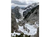
Today from Rudno polje towards Srenjski preval, but at Kačji rob abandon plan and turn to pathless east ridge of Viševnik. So this peak unexpectedly joined the trip. After descent to mentioned saddle continue under Mali Draški vrh and on to Veliki brat. From it descend ridge to Studorski preval. Before reaching it, start looking for characteristic rock as Garmont describes (see conditions: Tosc -> two posts with pics and short desc). Bad luck only that from my side not sharply pointed at all. Since didn't spot better candidate and no will to descend more to see its characteristic shape, started crossing. When reached spot for "right" passage over the slab, several options opened which I could choose, difficulty probably similar. Hope I chose the one Garmont mentioned.
Surprisingly no company on summit, even jackdaw just flew over and gone.

Return via main trail Vodnikov dom - Rudno polje, where quite lively, short-of-breath and sunburnt. Hope cooling ointments or yogurts helped the poor later.
Where you branch off from the Kačji rob path onto the ridge1
Chamois surely didn't stack this2
View back3
Through dwarf pines to the flattening and ridge continuation4
More artistic nature5
All 4 limbs are needed, probably possible to bypass the dwarf pines on the right6
Then I struggle a bit more in the dwarf pines and soon reach the markers below Viševnik summit7
Beautiful day8
Below Mali Draški vrh9
This time along the left side instead of the right edge to VDV10
Peek at the wreath Rž, Rjavina, Luknja peč11
Tosc, Mišelj vrh, Kanjavec, Šmarjetna glava, Vernar from VDV12
Ridge descent to Studorski preval with Ablanco on the adjacent side13
Bela milina14
This is how the rock looks from above where I turn towards Tosc15
To the grassy clearing that is a really nice promontory16
View back towards the distinctive rock17
At this spot no longer towards W, but steeply upwards18
The chosen passage is slightly right of the highest grassy patches - almost in the middle of the image19
A few grips on the rock and I'm already at the edge20
Just a short stroll to the top of Tosc21
Triglav with Planika and Kredarica22
23
(+4)like
Page:123...141516
You must log in to post a comment:
Username:
Password:
Login
If you do not yet have a username, you must first register.
         
Copyright © 2026 Hiking-trail.net, Terms of use, Privacy and cookies