|
| IgorZlodej7. 09. 2011 18:00:37 |
I was on Terza Grande for the first time four years ago, but since once is never, I had to return. Since there is no useful description here yet, I will describe it. The best starting point for the mountain is Pian di Casa in Pesarina valley via Mimoias pasture, to it also from Val Frison valley or Sapada, precisely Granville. In any case need to reach passo Oberenghe. With buddy this time from below forcele Lavardet, past Mimoias on path 202 to Enghe pass, here opens great view on Monte Brentoni and Dolomite giants in background, Civetta, Pelmo, Antelao. From there continue on almost flat path to junction of path 314 coming from Val Frison. In less than half hour at Oberenghe pass, from there descend few meters to north side, then path takes us left immediately and starts steep ascent on grassy SE slopes of Great Terza. When crumbly, partly grassy and rocky terrain ends and ahead only rock slopes we leave sticks (safe to leave here for now) and put on helmets. Route easy to follow as marked by red dots and cairns, climbing not difficult as mostly walking. Summit part somewhat more demanding but hardly any spot reaches II difficulty. Crossing short chimney almost at summit eased by rope which still reliable though looks bit weathered. On top opens magnificent view reaching highest Dolomite peaks, High Tauern and of course our Julian Alps. Well that was today, maybe not always so nice. On top we took quite long break as shame to miss such views. Descended same way up. Followed visit to cheese dairy at Razzo saddle, then through Val Frison (there meet tireless cyclist and acquaintance from two years ago from Monte Siere and Zovo Rito hut from Campolongo), exchange few words and she invites again to visit in Campolongo. Road to valley unchanged for some years, bad, officially closed but all with bit higher cars drive.
 1 1 2 2 3 3 4 4 5 5 6 6 7 7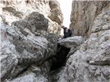 8 8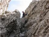 9 9 10 10 11 11 Grossglockner") 12 12 13 13 14 14 15 15 16 16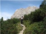 17 17
|
|
|
|
| IgorZlodej10. 08. 2014 20:03:47 |
This time due to a web of circumstances from Granvile or the village Palu in Sunny Valley. The path through the valley is long, then it nicely starts to ascend. Some fallen trees don't bother much, otherwise nice path. The ascent to the summit is eased by fresh blazes marking the ascent direction, the old rotten rope has been replaced since the last ascent by a freely hanging steel cable. After descent we go over Oberenghe pass and Mimoias pass to the south side, then climb to Elbel pass and down the nice path to the valley.]]>
| (+5) |  | |
|
|
|
|
| IgorZlodej31. 08. 2015 17:01:24 |
This time from F. De Gasperi hut below Campanile di Mimoias to Mimoias saddle, then to Oberenghe pass. The continuation to the summit has been described many times, the steel cable is still in place and helps the less skilled with the ascent. We descended via the abandoned Mimoias pasture to the starting point Pian di Casa.]]>
| (+2) | | |
|
|
|
|
| Edina1. 08. 2017 12:41:03 |
| (+3) | | |
|
|
|
|
| Edina17. 08. 2017 22:21:41 |
, just because of them we girls will have to repeat the tour
mirank, on the first day we drove to all the starting points from which we had planned tours, so we wouldn't encounter surprises during the rest of the vacation or make unnecessary detours. Among others also from Campolongo along Val Frizon, specifically on the principle that maybe despite the traffic sign that the road is closed, it might still be possible. Well, there were physical barriers on the bridge so we were convinced it really wasn't possible and besides Val Pesarina which was also occasionally closed, we used Val Piove. I wrote this so no one tries from the other end (from F. Lavardet direction), because there the barriers can be bypassed.
Happy trails and also on the roads leading to them ]]> ]]>
| (+1) | | |
|
|
|
|
| mirank18. 08. 2017 08:51:04 |
). We on Tuesday went to Brentoni through Val Pesarina and as Bagi writes actually a bit above Pian di Casa due to overpass-bridge construction (road crosses ski slope) there's a road closure sign (with drawn detour) and arranged detour about 100m on gravel. In my opinion you can drive there even on weekdays. I wasn't paying attention but I think the starting point for T grande is a bit higher than the construction site. We returned via Sauris
Safe steps]]>
| (+1) | | |
|
|
|
|
| bagi18. 08. 2017 09:30:34 |
The closure is on the road marked with pink line on the map. The bridge is being built exactly where we finished the return from Terza Grande via path 314. Despite the ban quite a few tried their luck but even motorbikers had to turn around.]]>
 1 1
| (+3) | | |
|
|
|
|
| dprapr13. 06. 2025 19:30:02 |
We didn't have the best views, but satisfaction that at our age we can still manage the efforts, though.
For ascent and return we needed 8 hours.
On return in Sappada we barely found an open place for coffee. Parking there is free until 1.7 too.]]>
| (+6) | | |
|
|
|
You must log in to post a comment:
If you do not yet have a username, you must first
register.