Zadnja Trenta (Flori) - Bavški Grintavec (via Kanski preval)
Starting point: Zadnja Trenta (Flori) (900 m)
| Latitude/Longitude: | 46,4043°N 13,7098°E |
| |
Route name: via Kanski preval
Walking time: 4 h 45 min
Difficulty: very difficult marked way
Via ferrata: B/C
Elevation gain: 1447 m
Elevation difference along the route: 1460 m
Map: TNP 1:50.000
Recommended equipment (summer): helmet, self belay set
Recommended equipment (winter): helmet, self belay set, ice axe, crampons
Views: 56.769
 | 9 people like this post |
Access to starting point:
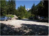
From Kranjska Gora, drive over Vršič Pass towards Bovec or vice versa, but only to the 49th hairpin turn of the Vršič road (near the village of Trenta). Here, turn onto the side road towards the source of the Soča River. After a short ascent, the road quickly leads to the parking lot in front of the Koča pri izviru Soče hut, but we continue left across the bridge and follow the road to the parking lot at the end of the road (near the parking lot, notice the mountain signs for Bavški Grintavec, the waterfalls of Suhega potoka, and Jalovec).
Route description:
Due to a landslide in 2018 that is still active, the path is closed until further notice!
From the parking lot, continue along the road barred by a barrier in the direction of Bavški Grintavec. Continue slightly left along the road that runs along the bed of Suhega potoka, while to the right a path leads towards Zavetišče pod Špičkom and Jalovec. We walk along this road for a while, then the path crosses the mentioned bed. At the crossing, we need to be a bit more careful as the trail is not visible here. On the other side, we can notice a wooden post with signposts. On the other side, the gentle path first leads past some private huts and then runs through the forest along the left side of the bed for a while. Further on, we will notice quite a few fallen trees along the path, which are the result of snow avalanches. A little later, the path brings us to a marked junction where the path to Zapotoški slapovi branches off to the left, and we continue right towards Bavški Grintavec.
The path then quickly brings us to the bed of a torrent where the trail is lost again somewhat. We continue a few meters along the bed, then cross it slightly to the right and head towards another torrent bed that we see slightly to the right. We begin to ascend along the left side of the mentioned bed and the path becomes visible again. After a short ascent, the path leaves the mentioned bed and turns decisively to the left.
Here we first cross slopes covered with bushes and scree, then the path leads us into a sparse forest. Further on, the path occasionally ascends somewhat steeper, and on a short section, a few pegs help us, with which we reach a viewpoint where a cross is also erected. Further on, the slopes we cross become even steeper and some caution is needed. Here the path crosses a few short steep gullies, and occasionally safety gear assists us.
Further on, the path mostly runs through the forest, but occasionally we still get nice views of the peaks above Zadnja Trenta.
We continue to ascend mostly traversely across steep slopes, and a bit higher, a view towards Zapotoški slapovi opens from the path.
The path soon leaves the steep slopes above the valley and leads us through the forest to Planina Zapotok. On the pasture, which has not been active for a long time, we continue to the shepherd's hut, and on the left side under the hut, we will also notice a stream that originates nearby.
On the pasture, the path turns slightly to the left and begins to ascend through a sparse forest. Soon the last larches disappear and wonderful views open up to Jalovec, Bavški Grintavec, and the peaks above the Zadnja Trenta valley. The path then ascends across grassy slopes and leads us to the scree under Bavški Grintavec.
Here we reach a junction where we head right towards Sedlo Kanja. The path over Sedlo Kanja to Bavški Grintavec is one of the most difficult paths in the Slovenian area, so descent via the somewhat easier path to the left is highly recommended.
We continue across the scree under the walls of Bavški Grintavec, then the path turns slightly right and begins to ascend towards Sedlo Kanja, where we reach another junction. We head left, while the right path leads towards Bavšica. Soon we reach the start of the climbing section of the path. First, the path along steel cables leads us to a vertical wall, which we climb with the help of brackets. When we reach the rock overhang, the path turns left and leads us across slightly overhanging traverses to the ridge. The path along the ridge remains very exposed and soon brings us to a crossroads where the mentioned easier path joins from the left. The path ascends steeply again and becomes increasingly crumbly. The path then leads across narrow passages and soon turns right steeply upwards, where we ascend with the help of a few brackets and pegs. Up to here, the path is also well secured with a steel cable, which is mainly for protection and, if you are not using a via ferrata set, will be more of a hindrance than help in many places. From here follows some easier climbing without protection across a very crumbly slope towards the summit, which rewards us with wonderful views in all directions.
Starting point - junction to waterfalls 0:30, junction to waterfalls - Planina Zapotok 1:10, Planina Zapotok - junction below Sravnik 1:20, junction below Sravnik - Sedlo Kanja 0:30, Sedlo Kanja - junction on ridge 0:30, junction on ridge - Bavški Grintavec 0:45.

Along the route: Odcep k slapovom (1009m), V koncu (1076m),
Planina Zapotok (1385m), Razpotje pod Sravnikom (1848m), Sedlo Kanja (2013m), Razpotje na grebenu (2166m)
Photos:
 1
1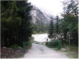 2
2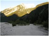 3
3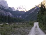 4
4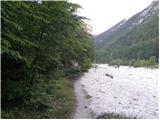 5
5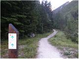 6
6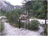 7
7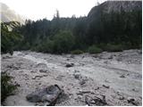 8
8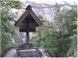 9
9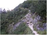 10
10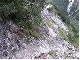 11
11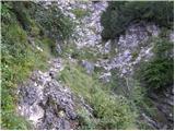 12
12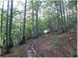 13
13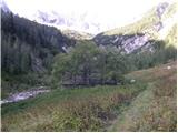 14
14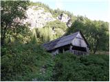 15
15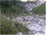 16
16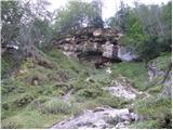 17
17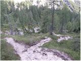 18
18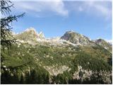 19
19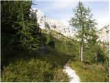 20
20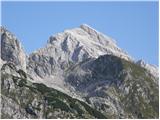 21
21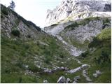 22
22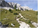 23
23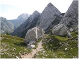 24
24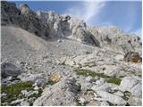 25
25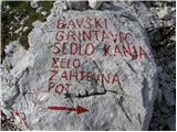 26
26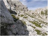 27
27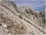 28
28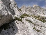 29
29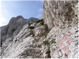 30
30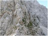 31
31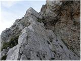 32
32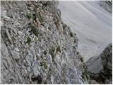 33
33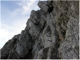 34
34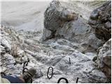 35
35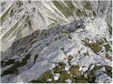 36
36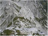 37
37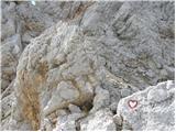 38
38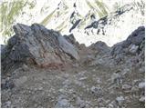 39
39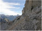 40
40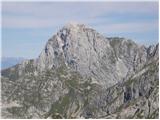 41
41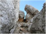 42
42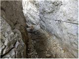 43
43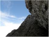 44
44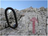 45
45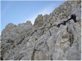 46
46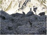 47
47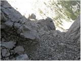 48
48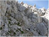 49
49 50
50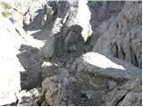 51
51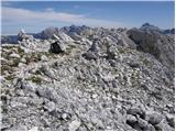 52
52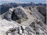 53
53
Discussion about the trip Zadnja Trenta (Flori) - Bavški Grintavec (via Kanski preval)
Show older messages
|
| mbohinc223. 06. 2008 |
Sunday trip to Bavški Grintavec via Kanja saddle was one of the most bombastic so far, I can compare it maybe only to Rjavina. The only annoying thing on this trail is the friability of the terrain, which after the adrenaline climbing is not exactly thrilling! Meta
|
|
|
|
| knap422724. 06. 2008 |
I'm interested in how much snow is still on the trail.
|
|
|
|
| francihabjan15. 09. 2009 |
Does anyone know what the conditions are like now? I'd like to go up this weekend.
|
|
|
|
| aljoša115. 09. 2009 |
I think this year it's no longer suitable for high mountains. There's now about 5 cm of snow at Kredarica. And this weekend doesn't look promising either.
|
|
|
|
| viharnik15. 09. 2009 |
What are you whining about. Mountains are hiked all year round, especially in winter when the temperature drops to the ideal -10°C for hiking.
|
|
|
|
| aljoša115. 09. 2009 |
Of course you can hike in the mountains in winter too, but with proper equipment.
|
|
|
|
| aljoša117. 09. 2009 |
I think there's no snow up there anymore, now it's just a matter of the weather.
|
|
|
|
| vilca4. 10. 2009 |
Today I was up via Kanja (1st league). All day sun, no trace of snow. From the via ferrata onwards the terrain is crumbly, if there's more traffic one needs to be careful (helmet mandatory).
|
|
|
|
| maiden4. 10. 2009 |
I was up there last week and yes, the path is very crumbly. I'm interested in what this via ferrata over Kanja is like, I mean is it "hard" 
|
|
|
|
| Okmodko21. 02. 2011 |
I went up at thirteen years old and simply shit my pants! Especially when I was on the vertical wall section. A few more pitons wouldn't hurt on the crumbly part. I've hiked almost all mountains in Slovenia, but this one really scared me. Or maybe I was too young, because now I never get that adrenaline anymore.
|
|
|
|
| miranm30. 06. 2012 |
Hello,
Since my wife and I are heading to the mentioned mountain tomorrow, I'm interested in how the fixed protections on the mentioned path are.
Thank you and best mountain greetings.
|
|
|
|
| miranm2. 07. 2012 |
Yesterday my wife and I set off on the mentioned path to Bavški Grintavec. The path to the Kanja saddle drags like a spring snake. From there the more difficult part of the path barely begins. Follows an ascent on brackets and along steel cables through very exposed sections (only for experienced and non-dizzy hikers) to the ridge, where an easier path joins us.
Then another ascent with the help of protections, because the slope to the top is very crumbly; I recommend extreme caution both on the ascent and descent to the valley. I agree with the description on Hribi.net that the path over Kanja saddle is one of the hardest in the Slovenia area. Despite the tour being very long, temperatures very high, full of adrenaline, you are rewarded on the summit with wonderful views.
Good luck and safe steps.
|
|
|
|
| ljubitelj gora5. 08. 2012 |
Did a circular route today, return via the harder one towards Kanja saddle, falling scree, just that someone a little below the summit triggers a whole landslide flying down protections are somewhat weaker in places, in some places a wire or peg more would be good, but it's manageable with caution. protections are somewhat weaker in places, in some places a wire or peg more would be good, but it's manageable with caution.
|
|
|
|
| goba129. 08. 2012 |
Walked the path 4.5.2012. We started from Bavšica. The uphill path is a bit overgrown but climbs very quickly. To sedlo Kanja approx. 2.30 to 3h walk. Morning is nice because you hike to Kanja in shade.
Climbing section uphill is bomb! From Kanja 10 meters on slight overhang exposure,... really pumps adrenaline. Helmet is mandatory because very crumbly, self-belay kit is good if you have it. Useful for return
|
|
|
|
| sportnick19. 08. 2012 |
Today we ascended Bavški Grintavec. Up via Kanski preval, down the direct path. The path is in my opinion one of the nicest, the ascent via Kanski preval offers satisfaction also to those who like to climb a bit. Protections are in good condition. Helmet of course mandatory. We also had self-belay kits. But I agree with predecessors that Bavški Grintavec is one of the most crumbly mountains, especially the last ascent before the summit when rocks crumble almost at every step. Therefore special caution is needed, especially for the safety of those below us. Luckily there weren't many of us on the path today.
|
|
|
|
| Tinca526. 08. 2012 |
Was there on Friday, up via Kanski preval and down the direct route. Nice, and also an adrenaline trail. On the path you really have to watch for rocks, especially since there are others below. No crowds in this area, in the morning I swept away all the cobwebs and at 9 was standing on the summit.
|
|
|
|
| dunjo30. 08. 2012 |
We were on Tuesday on BG, up through Kanja and down the direct way. My most adrenaline-filled hike so far. Some protection in the last half hour really wouldn't hurt. I don't know why it says 6.5 hours at the start, the sign scared us a bit. We needed a good four hours for the hike. Soon we're heading to Hanzova on Prisank, and I'm interested in some comparisons between these two hikes. Thanks and light steps
|
|
|
|
| miri30. 08. 2012 |
Nothing bad if you arrived earlier. On Tuesday there was a great view, of course, if you weren't in a hurry to the valley.
|
|
|
|
| ljubitelj gora30. 08. 2012 |
It's hard to compare the two trails, both are very demanding, probably BG confused you, because under the summit everything crumbles, there's a lot of scree, the ridge above Kanja is exposed and some pegs are missing, Hanzova is long and also exposed, before Hudičev steber the trail turns right along ledges and then up, there be careful if there are hikers ahead of you, better wait.
|
|
|
|
| klavdy614. 08. 2013 |
What is the comparison of the path to BG with the path Okrešelj-Mrzla gora? Thanks
|
|
|
|
| trma55514. 08. 2013 |
To me it's approximately the same, maybe slightly harder on BG, but for both helmet and full measure of caution apply.
|
|
|
|
| dprapr14. 08. 2013 |
On BG it is better protected but more crumbly and incomparably longer!
|
|
|
|
| mailman22. 07. 2014 |
Hi! I'm interested in the weather forecast for tomorrow, does anyone have an accurate and reliable forecast for this mountain?
|
|
|
|
| julya22. 07. 2014 |
Why does the hribi.net portal exist?rollingeyes:click list of mountains/Bavški Grintavec/weather forecast. The most detailed possible!
|
|
|
|
| sirt122. 07. 2014 |
However, an important item is missing - wind!
Tomorrow morning (Kanin) 52 km/h
|
|
|
|
| mailman23. 07. 2014 |
Julya, this forecast is not necessarily accurate, it has already screwed me over, as has ARSO today!!! Some have links to nearby weather stations that are more accurate. Thanks for the replies!!!
|
|
|
|
| Dkrepfl12. 08. 2014 |
Hi, does anyone know if there are still any snow patches on the path and how many? On Saturday I plan to go up the direct route, but I don't have winter gear.... Are poles enough? Thanks for info
|
|
|
|
| IgorZlodej12. 08. 2014 |
Trekking poles won't help you to the top of B.G., because you need both hands.
|
|
|
|
| zlatica12. 08. 2014 |
som69, very nice pictures, only one small thing bothers me, that you write Kanski preval instead of Kanjski! Small thing, but not entirely unimportant. Sorry!
|
|
|
|
| zlatica13. 08. 2014 |
som69, I'm responding once again on the same topic... I take back some of the criticism I directed at you, because that very "small thing" intrigued me so much that I went to check various literature, maps, and found that in this case there is no great consistency anywhere. On one side we have the saddle Kanja with "j" (this is evident also from 2 of your pictures, with markings on the rock), on the other side Kanski preval without "j", which is completely illogical, as the saddle or pass derives from the word Kanja - the nearby peak (1846m). I think this inconsistency in naming the saddle arose because people started omitting the letter "j" in the adjective form "kanjski", since it's easier for most and due to carelessness. It would be interesting for me to learn this explanation from some linguistic expert familiar with mountain names, like e.g. Stanko Klinar. But for now, let that be enough from me on this.
|
|
|
|
| molekk17. 08. 2014 |
After today's ascent to BG I would warn about the rocks 100m below the summit, which are just waiting for
the descent. You proceed upwards over them after all.
|
|
|
|
| darinka429. 10. 2014 |
On October 27th I was on Bavski Grintavec. There was still a lot of snow. Higher up in the wall it was icy in places. I successfully climbed over Kanski preval saddle. Real pleasure. Then the summit. WEATHER great, but I was completely alone, no one was there that day. For the descent I decided, snowy-
|
|
|
|
| darinka424. 05. 2015 |
I like going to this beautiful peak, almost always alone. I enjoy the pristine nature. And somehow I have to overcome the fear of falling rocks just below the summit. It happened to me twice on the descent. You can only wait what will happen. Happy ending. I enjoy climbing in the Kanja saddle. I don't need a via ferrata set, just strong arms and legs, and the thought that you're completely alone and no one can help you. But the summit rewards all the effort on the ascent.
|
|
|
|
| Branee25. 05. 2015 |
I think which sentences from them ooze your asociality. Look at these two of your posts:
29.10.14 - text..WEATHER great, me **completely alone**, no one that day. text..
24.5.14 - I like going to this beautiful peak, **almost always alone**. text..I don't need a via ferrata set, just strong arms and legs, **and the thought that you're completely alone and no one can help you**. text..
PS: today there are more people out (nice weather), just warning you so you won't be completely alone.. 
|
|
|
|
| ljubitelj gora25. 05. 2015 |
Via ferrata set is recommended, but not necessary, I myself have climbed many such and similar climbing sections, but I prefer pathless terrain, well, depending sometimes.
|
|
|
|
| CarpeDiem24716. 08. 2016 |
Yesterday we summited BG from the direction of the Soča spring. Ascent via Kanja and then descent from the summit via the direct route, or one colleague went straight to Soča village because he opted for the easier descent option.
This post is not meant as an invitation or encouragement to hike the officially closed path, but from firsthand experience I can say that the fixed cables and pegs are undamaged, though there is a lot of scree and stacked rocks/stones on the rocks. So caution is definitely not superfluous, but the route is realistically doable without mountaineering aids if you don't want them.
|
|
|
|
| B216. 08. 2016 |
It would be great to attach a photo of the critical section...
|
|
|
|
| M&P23. 06. 2017 |
I know the path is officially still closed, nevertheless I'm considering a trip from Bavšica over Sedlo Kanja and return via Vrh Brda, and I'm wondering if anyone has been walking around there recently given that CarpeDiem's post about the condition is almost a year old?
|
|
|
|
| darinka423. 06. 2017 |
Last year on 19.6 I went up and also down over Sedlo Kanja. There was quite a bit of scree on the path and some snow. The path over the saddle is, they say, one of the harder ones and quite exposed. Towards the summit in the last part of the path there is danger that some stone might be triggered. I already got a load, luckily past my head. Therefore, if you are heading up, be careful.
|
|
|
|
| Rabraminca2. 07. 2017 |
It's still quite dangerous in the gully just below the summit, but there will be a federal action to renovate this problem this year.
|
|
|
|
| jaksetici28. 08. 2017 |
I was at the summit on Saturday, 26.8.2017. Starting point valley of Bavšica past planina Bukovec, over Kanjsko sedlo to the summit and then over Mali Grintavec back towards Planina Bukovec and down the Tesna gorge back to the starting point.
The path over Kanjsko sedlo is in my humble opinion VERY (!) dangerous and not for poorly prepared hill walkers! Self-belay kit highly desirable, helmet essential!
Given that the path over Kanjsko sedlo has been closed since last July and due to general danger, they should PHYSICALLY block the passage on this path until it is restored. After all, the mountain is listed in the Extended Slovenian Mountain Trail!
As a reward for all the effort invested to reach the summit, of course there is no stamp anywhere! Great, fine! I'm wondering how many months, years have these deficiencies been known, and nothing moves?!
More than all that, I am disappointed with the condition of the path from the summit along the ridge to M. Grintavec and then further into the Bavšica valley. Namely, the condition of the markings is mildly said CATASTROPHAL! I doubt they have been renewed this century. If you find any, they are in very poor condition, colors faded, many lost due to various rockfalls etc. I myself got off track at least 3 times. Only after several attempts and looks from different directions did I manage to find a decent marking that led me on. And that in sunny weather! What if fog appeared...???
Let me say that the markings in the Kamnik-Savinja Alps can be a model of how to mark paths. As for any junction signs, we can only dream in that area.
|
|
|
|
| darinka42. 09. 2017 |
How was it towards the top? So the last part of the ascent..? Stones fly there sometimes.
|
|
|
|
| jaksetici12. 09. 2017 |
darinka4, I won't say that a helmet is mandatory - if you care at least a little for yourself and someone walks ahead of you, it is HIGHLY recommended. I got one recently and must admit it doesn't bother me at all. After all, nowadays we have helmets in every sport, so...
Best regards,
I.
|
|
|
|
| sonny419. 06. 2018 |
Today over Kanski preval to BG. Markers in abundance, signposts carved into rocks, fixed protections correct. Positively surprised by this path, quite a bit of fun scrambling. But need to consider it's a very demanding path, as written everywhere.
@jaksetici I hope markings in KSA won't be example to any marker. In my opinion it's sometimes already tasteless scribbling and violence on mountains. Too many. Worst around Češka koča. One of the charms of mountaineering is also being able to orient ourselves sometimes on our own, not just blindly follow markers and flip through SVK.
|
|
|
|
| Marjetica612. 08. 2019 |
Hi.
Does anyone know if the trail to the summit is still closed?
Regards
|
|
|
|
| darinka412. 08. 2019 |
Probably still closed. Because the terrain there is crumbly. Otherwise, from the village Soča it's a nice tour to BG. Without a single cable or chain on the path. With beautiful views. Just long but doable in one day.
|
|
|
|
| Marjetica613. 08. 2019 |
Thanks for the information!
But it's precisely because of the cable and the gully that the trail appeals to me! If there's no other way, we'll head off from Soča too
|
|
|
|
| darinka42. 11. 2020 |
Another approach to Bavški Grintavec is from Bavšica over Vrh Ruš and Vrh Brda over Mali Grintovec. It's quite a long tour. Without fixed protection. The hardest is the last part from Mali Grintovec to the summit. Definitely one of the nicer solitary tours where you rarely meet anyone.
|
|
|
|
| darinka43. 09. 2021 18:04:59 |
I'm wondering if anyone has walked this path from Bavšica over Mali Grintovec. Due to fallen trees. Is it possible on the path?
|
|
|
|
| djimuzl3. 09. 2021 18:19:50 |
Darinka, you didn't post on the right forum.
|
|
|
|
| djimuzl3. 09. 2021 18:35:33 |
Since the path from Bavšica is not in the descriptions, try in the Conditions section. Unfortunately, Igor is no longer with us, who had such information at his fingertips..
|
|
|
|
| sla3. 09. 2021 20:35:09 |
I wanted to reach Bavški Grintavec from Bavšica at the end of August (less than 14 days ago). The most telling data is that I needed 1 hour and 20 minutes from car to car
In short - the path is impassable. 5 min from home, fallen trees begin. You can still push through them. Then a wall of ice appears, 1 m to 10 m high. That's the remnant of avalanches. There I ran into a German and we pushed through under the ice together - an ice tunnel about 20 m long formed. When we got out on the other side, we were in a gully and couldn't find the path at all. Higher up, fallen trees and avalanche remnants appeared again. We pushed through boulders, fallen trees, and bushes for a while, then realized it was pointless and turned back. But the German told me that the previous day he went to the left valley to planina Bala - the path is normally passable and lots of markers. During our struggling, we found only one marker before the ice tunnel and nothing else.... In desperation, I then went to Krn 
|
|
|
|
| darinka43. 09. 2021 20:50:52 |
I suspected something like that. But I know that to Bala it's passable. Although there are quite a few fallen trees there too. Thanks for the detailed report.
|
|
|
|
| darinka44. 09. 2021 10:26:00 |
I just got data and some photos from yesterday when someone went there. He managed to get through the snow tunnel. Then between the boulders. And from the hunting hut there were no more problems. It seems some snow has melted.
|
|
|
|
| Fore8. 08. 2023 13:01:14 |
Hello,
I'm interested in which path is recommended, safe, and open.
Thank you and safe steps.
|
|
|
|
| sla8. 08. 2023 16:14:05 |
Only the path from the village Soča satisfies all three conditions.
|
|
|
|
| LISAC3. 07. 2025 21:35:16 |
Hi.
Did anyone go over Kanja saddle to BG last year or already this year and can provide some info from the ground? Thanks in advance
|
|
|
|
| B23. 07. 2025 22:56:42 |
Very demanding path; Kanja saddle - Bavški Grintavec has been closed for several years due to an active landslide. Crossing it is deadly dangerous!
|
|
|
|
| LISAC4. 07. 2025 13:29:41 |
B2 thanks for the comment. What more do you know about the landslide or what exactly is going on? Best regards
|
|
|
|
| turbo4. 07. 2025 17:21:11 |
On the PZS website - path conditions it says:
Kanja ridge-Bavški Grintavec SW
Closed section of path.
Date: 03. 07. 2018
Reason: SLO: Lightning and water triggered a landslide that severely obstructs access to the summit of Bavški Grintavec. The landslide is still active, therefore the path is CLOSED until further notice.
|
|
|
|
| pantharej4. 07. 2025 17:30:48 |
I went there last year. That landslide is less than 10m wide and with a bit of caution it can be crossed. Obviously there's no interest in opening this really nice path, it's easiest to just close it. But the whole path is a proper Trenta very demanding one and there are quite a few sections on it that are harder than the landslide.
|
|
|
|
| B24. 07. 2025 18:51:03 |
Yes. The landslide might indeed be ten meters wide.
But how high is it? That landslide reaches about fifty meters in height and in case of rock dislodgement it would sweep everything below it. Debris and smaller rocks upon triggering fly all the way to that narrow section of the path under the rocks. You have nowhere to take cover from flying rocks. The path is planned for relocation to a safer route and is managed by PD Jesenice. The path is not closed without reason!
... I would ask that on the forum you refrain from such comments and do not deliberately put people in deadly danger!
|
|
|
|
| LISAC5. 07. 2025 00:08:38 |
Thanks to everyone for the info. The more there are, the easier it is to imagine the situation.
|
|
|
|
| pantharej5. 07. 2025 09:46:23 |
I browsed the forum a bit and found Igor Zlodej's post from 18.8.2016. Nice description of the condition, but apparently PD Jesenice has no interest in fixing the trail. We must know that many people ignore closures, as shoe prints are clearly visible on the landslide. As I wrote, the easiest is to close the trail and abandon it. When I look at the PZS page, if this trend continues, half of the trails will be closed in ten years because of one pulled peg.
|
|
|
|
| miri5. 07. 2025 11:09:02 |
Are you aware that someone is responding about an open (or closed) trail?
|
|
|
|
| LISAC5. 07. 2025 22:08:18 |
Just one more thing. I opened this discussion this year. When searching for information in preparation for the tour, I came across the Western Julian Alps guide where the author, in collaboration with the umbrella organization PZS, gives an opinion on the mentioned trail/tour. Note that the guide was published a few years after the landslide. It highlights that the trail over Kanja saddle is currently closed (still...), but provides some basic information and that field information is needed before attempting it. That's exactly what I did here because I like to prepare as best as possible. Maybe if a section has been closed for so many years, it doesn't mean it's not feasible with certain considerations and also with luck. Best regards
|
|
|
|
| padez12. 08. 2025 20:03:06 |
Today I watched a video that also has a shot showing the ridge path between the summit of Bavski Grintavec and the Kanja saddle. This secured path is supposed to run along the ridge, or below the ridge on the Bavsica side. As I saw from the footage, it is not there or poorly marked. The path is very demanding and is secured in a few places with cables and pegs. Then I went to look at the Trenta 1:25000 map and noticed that the path is drawn in, albeit quite "timidly". I wonder why this section of the mountain trail, if it exists, is not described anywhere? I also suggest marking this section and canceling the path through the active landslide. Maybe I'm wrong? At the first opportunity, I will check the situation up close and also visit the path that I didn't know about until now...
|
|
|
|
| mimir3. 09. 2025 09:56:17 |
Hello!
I'm interested in how long the climbing sections are and if the path is also suitable for dogs.
Thanks in advance for the reply!
|
|
|
|
| bongo3. 09. 2025 11:17:30 |
Isn't that secured climbing section described right in this thread? Just that the descent was from Kanja to Bavsica and not to Zadnja Trenta. (if we mean the same circular tour video)
With a dog to BG via Kanja?  Maybe with a chihuahua in the backpack... Maybe with a chihuahua in the backpack...
|
|
|
|
| padez3. 09. 2025 14:06:13 |
@bongo, I didn't find a description of that section. The path from the top of Bavški Grintavec is dashed on all maps on the other side of the ridge (side above Bavsica) and starts a bit below the summit of Bavški Grintavec and ends a bit below the Kanja saddle where it joins the marked path Kanja saddle - Bavsica. Here you can then decide to ascend Kanja and descend to Zadnja Trenta and thus "bypass" the closed part of the path over the active landslide. Don't take my word for it, as that's how I interpreted the video posted by that hiker "živjo, živjo! jaz sem Peter". As for accompanying a dog to the summit, I'd only go from Soča.
|
|
|
|
| sh3. 09. 2025 17:03:41 |
This video was recorded on the marked path, which has been closed for a few years. The video also shows and explains where the landslide is.
|
|
|
|
| padez3. 09. 2025 17:43:05 |
I don't think that's correct. If the footage was on the marked path, the valley downhill would be on the right side, but it's on the left. So it's the path that was once marked on the Bavsica valley side, while the landslide is on the Trenta side. And the path shown in the video branches off from the now closed path above the landslide.
Maybe I'm wrong. But I'll convince myself if it's true maybe this year.
|
|
|
|
| bongo3. 09. 2025 18:13:01 |
Peter went from Bavsica via Mali Grintovec to BG and through Kanje dol. He didn't go along the closed path. This part is definitely unsuitable for wimps of all kinds.
Unfortunately, you can't add photos here for better illustration.
|
|
|
|
| padez3. 09. 2025 20:35:32 |
Yes, it was like that. But from the top of BG to Kanja, he didn't go along the closed path, but along the once accessible and still usable path on the other side of the ridge. The closed path runs along the eastern side of the ridge, while he went along the western side of the ridge. Old pitons, old cables, and faded markers are visible. On the closed path, there are newer pitons and newer cables.
|
|
|
|
| sh3. 09. 2025 22:31:10 |
I don't want to discuss too much, but from Bavški Grintavec towards Kanja there is only one path, which is closed from the top to the junction into Zadnja Trenta.
|
|
|
|
| Hammond4. 09. 2025 16:56:38 |
It's not good to watch too many influencer videos. You have to go to the terrain yourself and realize that he is right.
|
|
|
To post a comment you must log in:
If you do not yet have a username, you must first
register.