Zadnja Trenta (Flori) - Bavški Grintavec (direct way)
Starting point: Zadnja Trenta (Flori) (900 m)
| Latitude/Longitude: | 46,4043°N 13,7098°E |
| |
Route name: direct way
Walking time: 4 h 30 min
Difficulty: very difficult marked way
Elevation gain: 1447 m
Elevation difference along the route: 1447 m
Map: TNP 1:50.000
Recommended equipment (summer): helmet, self belay set
Recommended equipment (winter): helmet, self belay set, ice axe, crampons
Views: 78.534
 | 4 people like this post |
Access to starting point:
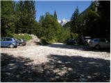
From Kranjska Gora, drive over Vršič Pass towards Bovec or vice versa, but only to the 49th hairpin bend of the Vršič road (near the village of Trenta). Here, turn onto the side road towards the source of the Soča River. After a short ascent, the road quickly leads to the parking lot in front of the Koča pri izviru Soče hut, but we continue left over the bridge and follow the road further to the parking lot at the end of the road (near the parking lot, notice the mountain signs for Bavški Grintavec, Suhega potoka waterfalls and Jalovec).
Route description:
Due to the landslide in 2018, which is still active, the path is closed until further notice!
From the parking lot, continue along the road closed by a barrier in the direction of Bavški Grintavec. Continue slightly left along the road running along the bed of Suhega potoka, to the right a path leads to Zavetišče pod Špičkom and Jalovec. Walk along the mentioned road for some time, then the path crosses the mentioned bed. At the crossing, be somewhat more attentive as the trail is not visible here. On the other side, a wooden post with signposts can be noticed. On the other side, the gentle path first leads past some private huts and then runs through the forest along the left side of the bed for some time. Further along, quite a few fallen trees will be noticed along the path, which are the result of snow avalanches. Somewhat later, the path leads to a marked junction where the path to Zapotoški slapovi branches off to the left, we continue right in the direction of Bavški Grintavec.
The path then quickly leads to the bed of a torrent where the trail is somewhat lost again. Continue a few meters along the bed, then cross it slightly to the right and head towards the other torrent bed visible slightly to the right. Begin ascending along the left side of the mentioned bed and the path becomes visible again. After a short ascent, the path leaves the mentioned bed and turns decisively left.
Here, first cross slopes covered with bushes and scree, then the path leads into sparse forest. The path occasionally ascends somewhat steeper, on a short section some pegs help us reach a viewpoint where a cross is also placed. Further on, the slopes crossed become even steeper and some caution is needed. The path here crosses several short steep gullies, occasionally aided by safety devices.
Further on, the path mostly runs through the forest, occasionally nice views open to the peaks above Zadnja Trenta.
Continue mostly transversely ascending over steep slopes and somewhat higher a view towards Zapotoški slapovi also opens from the path.
The path soon withdraws from the steep slopes above the valley and leads through the forest to Planina Zapotok. On the planina, which has not been active for a long time, continue to the shepherd's hut, on the left side under the hut a stream originating nearby will also be noticed.
On the planina, the path turns slightly left and begins ascending through sparse forest. Soon the last larches disappear and wonderful views open to Jalovec, Bavški Grintavec and the peaks above the Zadnja Trenta valley. The path then ascends over grassy slopes and leads to the scree slopes below Bavški Grintavec. Here we reach a junction, turn left. The right path leads over the Kanja saddle to Bavški Grintavec and is one of the most difficult paths in the Slovenian area.
Continue left and begin ascending over the scree, soon the path turns slightly right and begins even steeper ascent towards the ridge where it joins the path from the Kanja saddle. The path ascends steeply again and becomes increasingly friable. The path then leads through narrow passages and soon turns right steeply upwards, ascending with the help of some brackets and pegs. Followed by some easier climbing without protection on a very friable slope towards the summit, which rewards with wonderful views in all directions.
Starting point - junction to waterfalls 0:30, junction to waterfalls - Planina Zapotok 1:10, Planina Zapotok - junction below Sravnik 1:20, junction below Sravnik - junction on ridge 0:45, junction on ridge - Bavški Grintavec 0:45.

Along the route: Odcep k slapovom (1009m), V koncu (1076m),
Planina Zapotok (1385m), Razpotje pod Sravnikom (1848m), Razpotje na grebenu (2166m)
Photos:
 1
1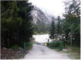 2
2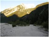 3
3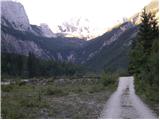 4
4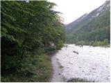 5
5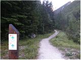 6
6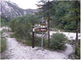 7
7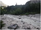 8
8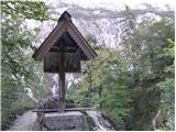 9
9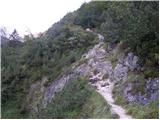 10
10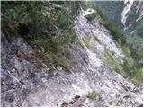 11
11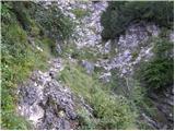 12
12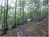 13
13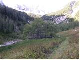 14
14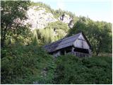 15
15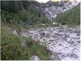 16
16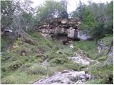 17
17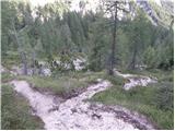 18
18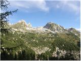 19
19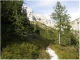 20
20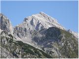 21
21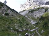 22
22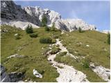 23
23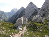 24
24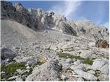 25
25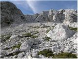 26
26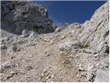 27
27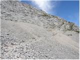 28
28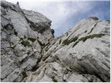 29
29 30
30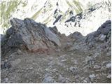 31
31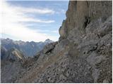 32
32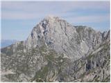 33
33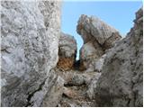 34
34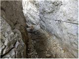 35
35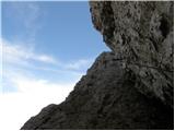 36
36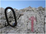 37
37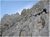 38
38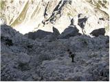 39
39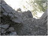 40
40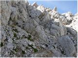 41
41 42
42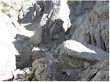 43
43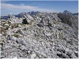 44
44 45
45
Discussion about the trip Zadnja Trenta (Flori) - Bavški Grintavec (direct way)
Show older messages
|
| alpina21. 03. 2010 |
It's a pity that the Zapotok pasture is completely abandoned and thus a real paradise for vipers
|
|
|
|
| lozarbogdan19. 06. 2010 |
I'm curious how much snow there is on the path and what the condition of the fixed protection is like if anyone has been there recently. Best regards.
|
|
|
|
| Bizy29. 06. 2010 |
Well that interests me too, what are the conditions (still any snow?). Has anyone been recently, that is these days, on this path? Thanks and a nice mountain greeting.
|
|
|
|
| godovčan29. 06. 2010 |
I was up there 25.6 from Koča pri Soči over Kansko sedlo via climbing path, where in the gully 15m wire is under snow, descended via direct where there's also no snow except when you reach the scree below Grintavec, no problems
lp david
|
|
|
|
| smidov david29. 08. 2010 |
Best regards
What is the difficulty of the direct path to Bavški Grintavec in terms of fitness.
Which path or summit can it be compared to.
What is the status of the stamp, have they replaced it? Which mountaineering association has this mountain under its auspices.
Thanks for the answers.
|
|
|
|
| škarnik30. 08. 2010 |
Regarding fitness, five hours is quite realistic if you're not rushing.
To me the route seems perhaps a bit harder than the path from Vrata to Skrlatica (technically), but a bit less strenuous and quite a lot more crumbly. The lower part is well secured, in the summit part you need to do some free climbing.
I was up there on August 10th, the stamp was pulled out, but it can still be used.
|
|
|
|
| joža x30. 08. 2010 |
The path from Vrata to Skrlatica is unknown to me, why compare it to Jalovec from Tamarja.
|
|
|
|
| irja20. 06. 2011 |
Has anyone been to BG recently by chance and can tell what the conditions are like? Thanks
|
|
|
|
| Mavrični28. 06. 2011 |
Does anyone have info on snow conditions on this path? Thanks!
|
|
|
|
| RumenOranzna25. 08. 2011 |
At the start from the parking lot in Zadnja Trenta there is a sign that the path takes 6h30min. The path is wonderful, but we were surprised by the extreme looseness of the summit (I assume that's why there are not many fixed protections). On individual exposed sections, it's hard to find a rock that doesn't wobble
|
|
|
|
| Zvonček25. 08. 2011 |
Is there a stamp at the summit of Bavški Grintavec?
|
|
|
|
| ruševec26. 08. 2011 |
The stamp was still on the summit on 3.8. Since the metal rod is pulled out of the rock, it can be freely carried around. Some have done that too. If no one has hidden or taken it somewhere, it's still up there. Bavški Grintovec is a mountain that really enchants you, whether there is a stamp or not. The approach is long, you walk practically the whole time in the wilderness. Far from the main hiking highways. Far from mountain huts. No excessive crowds either. Along the path there are waterfalls, the abandoned Planina Zapotok, forest reserve of larch forest, herd of chamois on the meadows, view of the entire Zadnja Trenta and surroundings. The snowfield is crossed in a very gentle part, almost flat. The section of the path between the talus and the ridge is quite awkward. No fixed protections, quite exposed. When I stepped onto the ridge and looked up at the wall, it squeezed me. The path is picturesquely routed through a narrow passage and channel. Less picturesque is the "scree" and that smooth steep rock. The climbing part of the path is short compared to the whole path. Only 1 hour out of 5 hours. Nevertheless, it must be taken seriously. Quite a few people have also descended this path. I think self-belaying is highly recommended for descent. Regarding the walking time written at the starting point, I think they exaggerate. It says 6.5 hours, but you can arrive very leisurely in 5 hours.
|
|
|
|
| joža x26. 08. 2011 |
On 11.08. there was a stamp at the top (pulled out) but it is already quite worn and needs replacement, because when you stamp it in the logbook you get a smudge from which it is hard to discern which peak it is for.
|
|
|
|
| Zvonček29. 08. 2011 |
Ruševec, I too must praise your description of the mountain. It really enchanted you. But I think I'll decide to go only to planina Zapotok, I'll just wait for the larches to turn yellow. That will be soon! LP
|
|
|
|
| škarnik29. 08. 2011 |
In contrast to Ruševec, I would add one more truly non-poetic sounding safety warning. If you look up from the "picturesque narrow passage" you will notice two indentations on the edge of the wall. The left one, which is more pronounced, is the outlet of a scree slope that the path crosses in the upper part, but stones can also be dislodged from the top and thus "slightly less picturesque scree" flies straight into the narrow passage (two, three meters up or down). Our group of four was narrowly missed by the first salvo yesterday, later when walking through the gully two more stone avalanches flew over us, and the stones bounced straight onto the path below the narrow passage. Fortunately nothing on the descent.
|
|
|
|
| Rogljiček9. 07. 2012 |
Last week my boyfriend and I did two ascents, via Hanzova to Mala Mojstrovka and from Flori Zadnja Trenta to Bavški Grintavec. Both trails are marked as very difficult. Hanzova is very well secured and never felt dangerous to me, while the climbing at the end of the trail to Bavški Grintavec is virtually unsecured, I agree with one of the previous comments, probably due to extreme friability, as many holds remain in your hand. Well, I turned back because of that, but my boyfriend with somewhat soft knees completed the ascent and returned the same way, without protection. I want to say that the marking - very difficult trail - can be misleading. The time estimate for hiking on this side is more realistic than the one at the parking lot of 6.5 hours. My boyfriend reached the top in 4 hours and 15 minutes. The climbing took about half an hour of that.
|
|
|
|
| matdra14. 08. 2012 |
Can someone tell me how the difficulty of the direct path to Bavški Grintavec compares to Kopiščarjeva on Prisank? More or less demanding?
|
|
|
|
| ljubitelj gora14. 08. 2012 |
I don't know Kopiščarjeva, but the direct route is easier than the one from Kanja, there's quite a big difference, so up via Kanja and down the direct.
|
|
|
|
| steyr14. 08. 2012 |
Hello!
Notice to PD Jesenice management. On Bavški Grintavec the stamp has been pulled out for more than a year and is also unusable... as instead of a nice imprint only a smudge is made. The logbook is also three years old, completely full and waiting for a new one!!! It is time to fix this a bit..... Best regards
|
|
|
|
| merkur15. 08. 2012 |
@matdra: I can't answer your question simply unequivocally (I think it's not possible anyway, since I don't know you), but the following sentences might still be useful to you ...
Both paths are declared as very demanding. Kopiščarjeva is considerably longer (comparing the more demanding, "climbing" parts of both) and overall better equipped. The rock on Kopiščarjeva is incomparably less crumbly than that in the upper part of the path to Grintavec, which is common to both variants - canyon and direct. The crumbly upper part of the path, which cannot be avoided from the Zapotok side (!), is less protected (in such rock the protections are unstable) and partly quite exposed - for the less experienced it can be quite scary (especially on descent). Such crumbliness is rare on marked paths in our mountains, so most people lack such experience. From all this it follows that the risk of slipping (the most common cause of accidents with us) is considerably greater on Grintavec. Earlier I wrote that the climbing part of Kopiščarjeva is longer ... True, but overall the tour to BG is longer and the difficulty is distributed differently; here the biggest problems are gathered in the last good half hour below the summit, when many are already failing condition-wise, and the same happens with concentration. One more thing: the tour to BG from Zapotok has always been considered one of the most difficult among our marked paths. Perhaps finally I agree with one of the predecessors who recommended (although long!) the path towards Soča village for descent - it applies to all those who would have doubts about safe descent during ascent (I know quite a few like that).
|
|
|
|
| jax15. 08. 2012 |
I can't make those comparisons myself, because I haven't been on Kopiščarjeva yet, on BG once a very long time ago, but as far as I remember this path I think Merkur's description is quite exaggerated. The thing is really very crumbly and especially if there are more people on the path (read on weekends) extreme caution is needed, but as far as I remember on the easier variant there are only two slightly steeper spots, one well protected, the other as far as I remember not at all. The rest is just scrambling on crumbly rock, where you mustn't do stupid things, but there are no special difficulties.
I'll put it this way: helmet is of course mandatory, but with a via ferrata set up there I don't even know what I would want. On Kopiščarjeva, on the contrary, I don't know if I would dare without. That's my opinion on the difficulty.
Oh, that steeper variant, yes, that one is more concrete. As said, it's been quite a while since I was there, but I still remember it quite well. There of course only with all necessary experience and equipment.
|
|
|
|
| jax15. 08. 2012 |
And regarding length: the path is indeed somewhat longer, but BG from Zadnja Trenta does not represent any special challenge for an averagely fit hiker.
|
|
|
|
| merkur15. 08. 2012 |
In my previous post I actually didn't write anything that you can't find in proven printed guidebooks or in previous comments. I added my experiences from visits to this path and many others ... I highlighted the differences between the two paths, because the question was posed that way. I agree that it is really difficult to compare two paths if you haven't been on one of them yet ... Also, whether you would dare to go on a path you haven't been on without self-belaying is very hard to know. 
|
|
|
|
| molekk17. 08. 2014 |
After today's ascent to BG I would warn about the exposed spot 100m below the summit.
Loaded rocks, over which you proceed upwards, are just waiting for the descent.
|
|
|
|
| CarpeDiem24714. 06. 2016 |
Within a month I'm heading to this summit. Up probably via Kanja and down this direct one. I have quite a bit of experience with high mountains and I'm not too worried.
I'm interested in the current status of both mentioned paths.
Happy trails to everyone in the mountains!
|
|
|
|
| IgorZlodej14. 06. 2016 |
Current status will be outdated in about a month  . .
|
|
|
|
| malimiha14. 06. 2016 |
Oh, I'd be interested in the current status of the direct path up and down. Thanks and regards, Miha
|
|
|
|
| IgorZlodej14. 06. 2016 |
I doubt anyone has been there yet, because it was still quite snowy not long ago and once again, if you're asking about conditions, ask under Forum - Conditions, there I can also attach a picture.
|
|
|
|
| Amritaya29. 07. 2016 |
I saw a notice online that the path to Bavški Grintavec is closed due to a rockfall, and it states: "ascent is possible from the village of Soča and from Bavšica via Mali Grintavec". Does this mean the summit is only reachable from the village of Soča and not via the direct path and Kanski preval?
|
|
|
|
| B230. 07. 2016 |
There is also access from the Bavšica valley past Kanski preval. The mountain path joins at PUS Bavšica and continues to Planina Bukovec, then at around 1450m branches off from the path to Kanski preval and continues right to Vrh Brda (2152m), where we reach the ridge and mostly follow it to the summit of Bavški Grintavec. Especially on the ridge, we must watch for old and faded markers, as the path descends slightly to the south side in a few places.
|
|
|
|
| j_ernej3. 08. 2016 |
On 17.7 we ascended the direct path, and continued the descent on the easy one to Soča village.
- in the first part of the ferrata the cables are not tensioned, but in good condition
- in the last part there was a lot of freshly broken rocks and every other rock loose. Possible that it's really closed due to rockfall.
|
|
|
|
| CarpeDiem24714. 08. 2016 |
Is the rockfall on the very difficult section or is the bypass realistically doable without unnecessary risk?
|
|
|
|
| CarpeDiem24716. 08. 2016 |
I'll answer myself based on yesterday's hike and the answer is that there were no such problems.
|
|
|
|
| maregol25. 07. 2017 |
Hi, is the bypass feasible this year at the landslide site?
|
|
|
|
| B226. 07. 2017 |
No, because the path has not been repaired yet. You do have the option to visit from the Soča direction or from Bavšica (but not over Kanski preval).
|
|
|
|
| maregol27. 07. 2017 |
OK thanks, obviously this path will be closed forever. Yes, I've already walked the others.
|
|
|
|
| B227. 07. 2017 |
I don't think it will be like that. This season it's scheduled for repair...
|
|
|
|
| darinka427. 07. 2017 |
Last June it was possible to go. I also went back over the Kanja saddle. But there was still snow.
|
|
|
|
| B227. 07. 2017 |
You can go in many places. The path is officially closed and there are justified reasons for the closure. Another thing is whether an individual will respect the closure introduced for weighty reasons, that's his business. In this context there is no policeman there to prevent someone from walking or punish him for it. I think the notice of path closure is sufficient for a reasonable user. My opinion is that with such "information" people are put into life-threatening danger. Using the mentioned path is life-threatening due to the collapse! Darinka, no offense...
|
|
|
|
| Koraki Nad Oblaki16. 08. 2017 |
Yesterday I was on BG via the climbing path from Kanski prelez. I didn't know about any closure and got to the summit normally, didn't meet any landslide. Apparently it's already repaired, the warning on PZS site is still up. Žiga is not at the top. I'll attach some more pictures soon.
|
|
|
|
| mornar18. 08. 2017 |
Please provide information where the stamp can be obtained if it's not at the top. Lp.
|
|
|
|
| wildjj18. 08. 2017 |
The stamp is at the top.
On 04.08.2017 I was at the top. The stamp is tucked behind
the summit log box.
LP.
|
|
|
|
| lepe planine18. 08. 2017 |
Wildjj, which route did you use to the top, any peculiarities, how much time does it take, or which one do you recommend???
|
|
|
|
| wildjj18. 08. 2017 |
I went up from Flori Zadnje Trente via Kanski preval. Descent via direct route. It was a very hot day so I took about 4 hours 45 min somewhere.
The path in the upper part is very crumbly (landslide area). Slowly and carefully it goes perfectly fine.
|
|
|
|
| el rocco2. 07. 2018 |
On Saturday, my wife, colleague and I tried to reach the summit via the direct path, but turned back 20 min below the top. In my assessment, the path in the last rocky section was so full of scree, exposed, simply too dangerous to continue safely. Additionally, the bigger problem is that it is simply too little secured and my opinion is that it urgently needs to be renovated otherwise someone will fall. For me it would have been the last stamp of the transverse, but I have never seen such careless attitude towards a path that is in the transverse, which is a pity because the mountain is wonderful, as are the views. In the hut at the source of Soča I inquired and apparently the responsible is PD Jesenice which I urge to respond urgently in this case and fix the path properly. Unfortunately, we will have to go to the summit again soon, but this time definitely from Soča.
|
|
|
|
| jax2. 07. 2018 |
On the last part of the path a landslide occurred, so it's even more unpleasant there now, we weren't used to it being like that. There was talk about it on the mountain conditions forum. Before that this path was completely ok, although it really wasn't secured in any way.
And of course - Bavški Grintavec is not in the transversal
|
|
|
|
| garmont2. 07. 2018 |
It is....in the extended.
|
|
|
|
| darinka42. 07. 2018 |
I also remember last year, at the end of October, the path below the summit was very gravelly. There I have already received a load of stones several times, but on descent.
|
|
|
|
| nmk24. 07. 2019 |
Today we tried to reach Bavški Grintavec via the direct path, but we turned back about 150m below the summit due to a rockfall. The Alpine Association website states that the path (both variants, via Kanja and direct) is closed, but it would be nice if there were some warning also at the starting point in Zadnja Trenta, and at the junction.
|
|
|
|
| georgia24. 07. 2019 |
Regarding the warning - yesterday we two were at the starting point at Flori (we actually went to the shelter under Špička) and we immediately noticed on the signpost that the sign for Bavški Grintavec is covered over, and next to it there is a notice that the path is closed, and in several languages. So the signpost currently doesn't direct to this path at all.
Good luck!
|
|
|
|
| TjašaS16. 08. 2020 |
Hello, does anyone know if the path is open again? Thank you very much for your reply.
|
|
|
|
| darinka416. 08. 2020 |
There was no announcement anywhere about the path opening. I doubt it will ever be open and safe again. But it is possible to go from Bavšica over Vrh Ruš, vrh Brda and Mali Grintavec to Bavški. Demanding fitness-wise, but interesting. Or from Soča. But over Kanja saddle from there is really not recommended.
|
|
|
|
| Fore8. 08. 2023 12:58:17 |
Hello,
I'm interested in which path is safe, recommended and open.
Thanks and safe steps.
|
|
|
|
| capraibex8. 08. 2023 13:26:23 |
The path is officially closed due to a landslide.
|
|
|
|
| boroot20. 06. 2024 18:51:11 |
Please provide information on the conditions on this trail - is it still closed?
|
|
|
|
| darinka420. 06. 2024 19:19:35 |
Didn't someone write that they plan to repair the landslide? Otherwise better not go there, as it's very crumbly.
|
|
|
|
| Hribolazec819. 08. 2025 10:53:00 |
Hi, I plan to take this trail soon, what's the situation with the landslide, is the trail open, can it be crossed?
Thanks
|
|
|
|
| djimuzl9. 08. 2025 11:14:44 |
Still closed. Read post B2 from 27. 07. 2017 a bit higher in this forum.
|
|
|
|
| Hribolazec819. 08. 2025 12:59:53 |
Thanks, which trail is open to BG?
|
|
|
|
| bo_zl9. 08. 2025 13:21:26 |
From village Soča to Lemovje to the alpine pasture above Soča and onwards to the summit.
|
|
|
|
| darinka49. 08. 2025 14:26:40 |
And from Bavšica over Vrh Brda and Mali Grintavec. The marks there have been renewed.
|
|
|
To post a comment you must log in:
If you do not yet have a username, you must first
register.