Starting point: Dolina Krma (930 m)
| Latitude/Longitude: | 46,3851°N 13,9071°E |
| |
Walking time: 3 h 30 min
Difficulty: difficult marked way
Elevation gain: 1084 m
Elevation difference along the route: 1155 m
Map: TNP 1:50.000
Recommended equipment (summer): helmet
Recommended equipment (winter): helmet, ice axe, crampons
Views: 55.432
 | 4 people like this post |
Access to starting point:
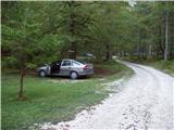
a) We exit the Gorenjska motorway at the Hrušica exit and continue following the road in the direction of Kranjska Gora. Just a little before the village of Dovje, a road branches off to the left from the main road, leading to Mojstrana (Vrata, Kot and Krma). We continue following the road in the direction of the village of Radovna and the valleys Krma and Kot. The relatively steep road then leads us past the TNP sign, after which the road soon levels out and brings us to a crossroads, where a gravel road branches off to the right into the Kot valley. We continue straight along the road, which begins to descend. In the middle of the descent, a road branches off to the right into the Krma valley (straight ahead Radovna). A little further on, we come to the next crossroads, where we continue right in the direction of Krma. The gravel road then brings us to Kovinarska koča, and we follow it further. The occasionally somewhat poorer road then brings us to the parking lot in front of the barrier.
b) We drive to Kranjska Gora, then continue driving in the direction of Jesenice. At Dovje we leave the main road and continue right in the direction of Mojstrana and the valleys Vrata, Kot and Krma, and at the next intersections we follow the signs for Krma. The relatively steep road then leads us past the TNP sign, after which the road soon levels out and brings us to a crossroads, where a gravel road branches off to the right into the Kot valley. We continue straight along the road, which begins to descend. In the middle of the descent, a road branches off to the right into the Krma valley (straight ahead Radovna). A little further on, we come to the next crossroads, where we continue right in the direction of Krma. The gravel road then brings us to Kovinarska koča, and we follow it further. The occasionally somewhat poorer road then brings us to the parking lot in front of the barrier.
Route description:
From the parking lot we return a few dozen steps back, then we head right (from the direction of access to the starting point left), towards the east on the path in the direction of Blejska koča na Lipanci. Initially we only climb gently, but after three minutes of walking the path becomes steep, and a few minutes higher we arrive under the cliffs, where we notice an inscription that the path we will be climbing further was built in 1952.
The path ahead climbs steeply through the forest to a somewhat more demanding crossing, where we are assisted by pitons, less steep steps and a steel cable. The path then leads us among the dwarf pines and we follow it further to a mighty torrent gully. To reach the gully we first descend a little, on the other side we climb transversely up the steep slope. Crossing the gully is made difficult or even impossible after heavier rainfall, however since the slopes are steep the water drains quickly. The path ahead then climbs through the forest, still steeply upwards. The path however gets closer and closer to the steep slopes and rock faces. When the forest becomes much sparser the path climbs even steeper and for a short time becomes so steep that we have to help ourselves a little with our hands. This part of the path is especially dangerous for slipping when wet, in dry conditions it does not cause greater danger. The path then leads us under steep rock faces, where there is a great danger of falling rocks, especially in springtime and after rain. We perform the crossing under the cliffs almost horizontally, then the path climbs again. Again we are helped by a steel cable, which leads us to grassy slopes. Next we again cross slopes exposed to falling rocks and soon after that we come to a less steep part of the path. Next we climb on an increasingly panoramic path mostly among dwarf pines and sparse forest to a junction, where we turn left towards Debela peč and Lipanska vrata (right Lipanski vrh and Mrežce).
The path ahead climbs transversely to the left and in a few minutes of moderate ascent brings us to Lipanska vrata, from which we descend a few steps to the junction.
We continue left towards Debela peč and Brda and Blejska koča (right Kredarica (peak above Lipanska vrata), Lipanski vrh and Mrežce) and continue the path transversely under the lesser-known Vrh nad Rdečim, where a belt of dwarf pines accompanies us along the way.
When the belt of dwarf pines ends, from the junction we continue on the upper path (slightly right Blejska koča na Lipanci), which leads further towards Debela peč.
For a few minutes we continue in a slight transverse ascent to the right, then two paths branch off to the left to the summit of Brda, the branches are a few minutes apart from each other, and from both junctions we continue straight.
After the second branch we gradually begin to descend, partly through a rocky section, partly through dwarf pines. Somewhere at the lowest point of this part of the ridge, a hunting path from the Krma valley practically imperceptibly joins us from the left side, and after a short ascent we reach a better worn path towards Debela peč, which leads from Pokljuka.
We follow the signs for Debela peč (right Blejska koča) and in the continuation on the left, western side we bypass the summit of Okroglež (the branch to the nearby summit is marked), a little further on the path that leads over the mentioned summit also joins us and is somewhat longer than ours. We continue straight and for some time continue without major changes in altitude. In the continuation a short gentle descent follows, then the path brings us to the slope of Debela peč, where it begins to climb more steeply.
For a few minutes we climb steeply, then we already reach the panoramic summit of Debela peč.
Starting point - junction below Lipanska vrata 2:25, junction below Lipanska vrata - Lipanska vrata 0:10, Lipanska vrata - junction below Vrh nad Rdečim 0:05, junction below Vrh nad Rdečim - first branch for Brda 0:05, first branch for Brda - second branch for Brda 0:05, second branch for Brda - junction below Okroglež 0:15, junction below Okroglež - Debela peč 0:25.

Along the route: Pod Lipanskimi vrati (1656m), Razpotje pod Lipanskimi vrati (1878m), Lipanska vrata (1905m), Razpotje pod Vrhom nad Rdečim (1903m), Odcep za Brda I. (1925m), Odcep za Brda II. (1962m), Razpotje pod Okrogležem (1941m), Odcep za Okroglež I. (1945m), Odcep za Okroglež II. (1936m)
Photos:
 1
1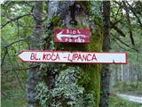 2
2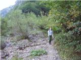 3
3 4
4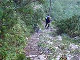 5
5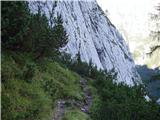 6
6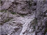 7
7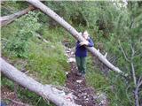 8
8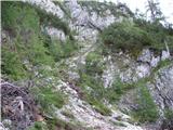 9
9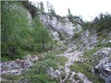 10
10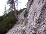 11
11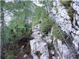 12
12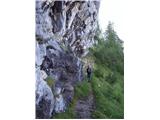 13
13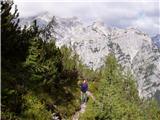 14
14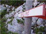 15
15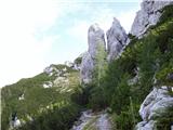 16
16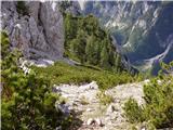 17
17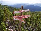 18
18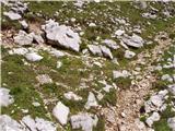 19
19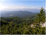 20
20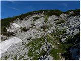 21
21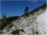 22
22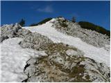 23
23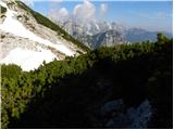 24
24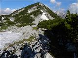 25
25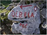 26
26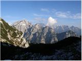 27
27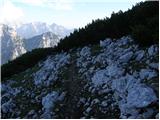 28
28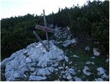 29
29 30
30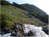 31
31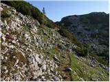 32
32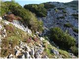 33
33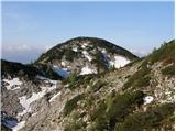 34
34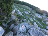 35
35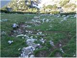 36
36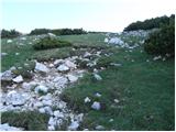 37
37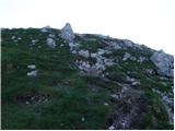 38
38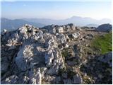 39
39 40
40
Discussion about the trip Dolina Krma - Debela peč
|
| ben12. 08. 2008 |
I'm wondering if anyone knows the hunting trail that starts behind Kovinarska koča in Krma and leads to the ridge between Brdo and Debela peč. I tried it myself but due to lack of time I didn't manage to get far enough, and I'm not even sure if I was on the right path.
What bothered me was that when you find the path and follow it upstream along the stream, about 100 meters higher at the water intake the path should turn right, but at 1200m it still hasn't, so I preferred to turn back.
I'd be very grateful for any information.
|
|
|
|
| Klin14. 08. 2008 |
The mentioned path would interest me too, but as far as I have heard, the upper part is completely buried due to avalanches.
|
|
|
|
| montana30. 08. 2009 |
I believe the difficulty rating is quite misleading as the path is anything but easy. Also on the 2006 Triglav National Park map the entire second half of the path is dotted, meaning difficult! Otherwise the path is well marked but very steep, the cables are quite unnecessary where they are, but would be welcome at some other spots where scree assistance is needed. Since the whole path is shady, rocks are wet or damp in places, requiring great caution.
|
|
|
|
| montana1. 09. 2009 |
Good that you corrected the difficulty rating. Commendable. regards
|
|
|
|
| heinz2. 09. 2009 |
I agree with Montana on difficulty, because if e.g. the trail from Kot to Staničev dom is partially demanding, this one is even more so, or hard to compare..
Today I went to check and have to say that the larger part, i.e. from Krma to Lipanska vrata, is quite dangerous, especially on descent when wet, which seems to be the case most of the day. Even in the afternoon the rocks were wet. That part where it says the trail is so steep that we have to use hands is the hardest, especially because there's not much grip available (a piton or wire rope would be necessary). If you slipped there, it would certainly be fatal.
Based on my previous experiences with easy and demanding trails, I would classify it as difficult.
|
|
|
|
| jax17. 08. 2012 |
Today up there and mostly agree with Heinz. The path is beautifully marked - completely new, maybe even too much. But obviously the markers got totally carried away, as seen by someone running out of white paint and part of the markings being just red circles without a dot 
I agree with what's said before: certain spots should be secured, especially those steep rocks at the upper passage of the gully. It's dangerous there, very much so.
Today everything still nicely wet, which made it even more fun, especially on descent. But okay, a trip for the mind, which is sometimes needed. Not the most pleasant possible tour, but all in all it was fine, actually more serious than I thought, and I felt pretty good after descending.
|
|
|
|
| Alfista18. 08. 2012 |
Then we two met. I also up and down and to be honest, up very nice, down pure suffering as I spent more time down than up. In the upper third quarter it's really dangerous and they should install at least some pegs on the passage mentioned.
I went early and despite it being very wet I had no problems (obviously good boots), after noon the sun is high enough and dries most of the path.
If it helps ... PD, advocate additional pegs, or even install a chain on that jump, because otherwise it's a shame, as the path is properly secured elsewhere.
Otherwise a great tour, especially for those who like peace.
|
|
|
|
| jax18. 08. 2012 |
Well, on Kovinarski itself we two met only one person - a solitary gentleman with a huge backpack, whom we caught just at snack during descent. If that wasn't you, we probably met somewhere in the summit part of the path, among all that crowd of Pokljuka hikers.
It's nice when the same mountain allows such different accesses - from those who drive to Pokljuka and go just for a short walk, to serious mountaineering tours. If a climbing team had just emerged from the north face at that moment, the hierarchy of visitors would be complete, but we two didn't have that luck
|
|
|
|
| Alfista18. 08. 2012 |
Well then no, because I saw the gentleman very close to the top, in between I apparently had a siesta on Brdih.
|
|
|
|
| katty19. 08. 2012 |
Well, today my friend and I ascended this route. The path uphill is really wonderful, varied and full of peace...and obviously so rarely visited that there are huge chamois families here, and we even met chamois kids. Given that Debela peč exceeds our "magical" limit by a few meters, I can say that the ascent from this direction is a proper tour. Just to add that some additional protections (maybe some pegs and brackets, not even cables) would be needed on this path, as with shorter legs you have to work hard for some steps  . .
Overall, the tour is wonderful and I'll probably tackle it again. The problem is then organizing transport back to Krma. A real little adventure.
|
|
|
|
| Petrca28. 07. 2014 |
Beautiful trail, but strenuous both up and down. The descent is quite challenging in places.
The listed walking time is unrealistic or given by someone who hasn't hiked the trail.
I recommend the trail only to "seasoned" hikers.
|
|
|
|
| Zebdi28. 07. 2014 |
Hm, what do I know. On the PZS page, the timetable is listed as 4h from Kovinarska koča to Debela peč, according to this description and if the map doesn't lie, the parking lot is 2-3km further from the hut; this, based on my experience with timetables in the Julians, means that the above mentioned 3 hours 15 min could be quite accurate. Unfortunately, I don't have Mihelič's guide at hand to check there too...
|
|
|
|
| gorolazka28. 07. 2014 |
Mihelič writes 4 hours from Kovinarska koča or 3.5 from the road to Lipanska vrata.
|
|
|
|
| garmont11. 07. 2015 |
In picture 2 - the upper sign is no longer there.
|
|
|
|
| misace22. 04. 2017 |
21.4.2017, Up to that gully on a dry and well-preserved path, but that undefined snowdrift turned me back.
|
|
|
|
| misace22. 04. 2017 |
I'd post a picture but there's no option?
|
|
|
|
| Tadej22. 04. 2017 |
Pictures can only be uploaded in the forum.
|
|
|
|
| karlin21. 06. 2018 |
Today I walked this path - need to cross a small snowfield, which is not dangerous, winter gear not needed. Otherwise the path is nicely groomed, need to step over a couple of fallen trees, otherwise all is fine. Path in shade uphill and downhill - best in this sultry day.
|
|
|
|
| Jusk28. 07. 2020 |
This path has been tempting me for a long time and today I tackled it, but almost no shade, true I went in the afternoon.. and the steepness to Lipanskih vratc doesn't let up, at times quite a tough path, but the views along the way and at the top make up for it all you have to be very careful on the descent, the steep parts of the path are full of scree and therefore very slippery.
|
|
|
|
| CarpeDiem24717. 01. 2022 10:16:16 |
As far as I understand your recommendations regarding descent, then the best is with two vehicles and return past the hut at Lioanci.
|
|
|
|
| Planinka746. 07. 2024 08:19:48 |
I'm interested if the path is completely dry? Thanks for the info.
|
|
|
To post a comment you must log in:
If you do not yet have a username, you must first
register.