Starting point: Soča (500 m)
| Latitude/Longitude: | 46,3425°N 13,6693°E |
| |
Walking time: 5 h 30 min
Difficulty: difficult marked way
Elevation gain: 1847 m
Elevation difference along the route: 1847 m
Map: TNP 1:50.000
Recommended equipment (summer): helmet
Recommended equipment (winter): helmet, ice axe, crampons
Views: 108.496
 | 5 people like this post |
Access to starting point:
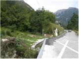
From Trenta or Bovec we drive to the village Soča, where by the road we notice the church. The beginning of the footpath is 200-300m from the church towards Trenta, where by the road we notice signposts and a smaller parking lot for 2-3 cars.
Route description:
From the village Soča we go on a footpath following the signs Bavški Grintavec. The path already at the beginning starts quite steeply ascending through the forest and in a good half an hour of walking it brings us to the mountain pasture or village Lemovje. Here the path at first turns a little to the left through a meadow, after that soon turns to the right and again starts steeply ascending partly through the forest, partly over steep meadows. The path then turns to the left, where the steepness slightly decreases. Next follows crossing of steep south slopes below Kol (1924 meters), which brings us to the hunting cottage on the mountain pasture Planina nad Sočo.
On the mountain pasture, the path turns to the right and ascends on grassy slopes and past fallen trees. The path continues to ascend over high grass on the south grassy slopes, and occasionally also ascends through the forest. The forest soon passes into dwarf pines and the path starts turning slightly to the right towards the small valley between Mali Grintavec (2282 meters) and Kol. After the ascent through the valley, the path brings us to scree below Bavški Grintavec. Here the path becomes pretty steep, and in the last part also slightly crumbly and exposed to falling stones. The described path is the easiest approach on Bavški Grintavec, but the path can also be very strenuous because it is all the time exposed to the sun.

Photos:
 1
1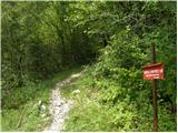 2
2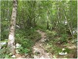 3
3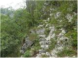 4
4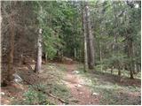 5
5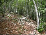 6
6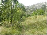 7
7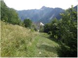 8
8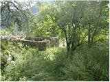 9
9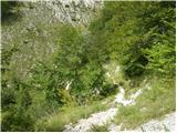 10
10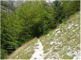 11
11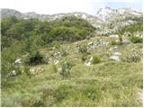 12
12 13
13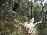 14
14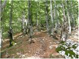 15
15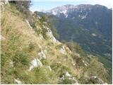 16
16 17
17 18
18 19
19 20
20 21
21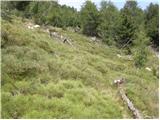 22
22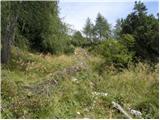 23
23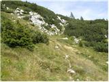 24
24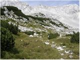 25
25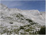 26
26 27
27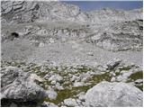 28
28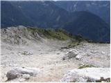 29
29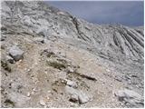 30
30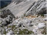 31
31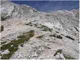 32
32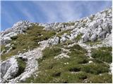 33
33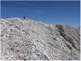 34
34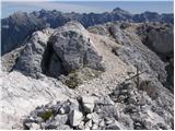 35
35
Discussion about the trip Soča - Bavški Grintavec
Show older messages
|
| Vera15. 05. 2010 |
Is there any water along the path, maybe at Planina Lemovje or by the hunting hut? Thanks!
|
|
|
|
| grahelj15. 05. 2010 |
There is no water on the path.
|
|
|
|
| ben15. 05. 2010 |
Mihelič in his guide Julijske Alpe says: ...from the village Soča we climb to the abandoned hamlet Lemovje along a steep path, which was once the only connection to the valley. We cross the sunny and scenic terrace past the largest group of houses and continue along a narrower path northwards into the open valley. Past two springs (the second is more reliable) the path heads into the Lemovje forest reserve...
I haven't been there myself yet, and whether it still holds true, I don't know, but according to the guide it should be. But in high summer I also doubt there's anything from that spring.
Best, B
|
|
|
|
| grahelj15. 05. 2010 |
Last year at the end of September there wasn't a drop of water anywhere.
|
|
|
|
| geppo15. 05. 2010 |
When I went from the Bavšica valley there was water at the hunting hut (but that was a long time ago)
Best
|
|
|
|
| šodrovec15. 05. 2010 |
Everything written above is true, but not always. The easy but long and hot southern approach in summer requires, besides good fitness, also a few extra kilograms on your back and at the same time good sun protection. So, Vera, don't think too much, but take enough water for the whole tour with you!
|
|
|
|
| geppo15. 05. 2010 |
Good advice!!
As thirsty as I was during the training for youth mountain leader in Bavšica, I've probably never been. Back then (around 1981) we only had one-liter canteens. We usually drank all the water by noon, then it was suffering and searching for snow patches.
There were some secret water springs that the leader showed us. Then we got a warning that chamois also drink there and we gave up.
Best
|
|
|
|
| Tomažke15. 05. 2010 |
A little further from Lemovje there was a wooden trough last year by the path. That's probably exactly what ben mentioned. Higher up, I doubt you'd get anything.
Last year, when my friend and I went from Zadnja Trenta to the summit at the end of September and descended to Soča, 3 liters of liquid was almost too little.
|
|
|
|
| AndrejG24. 07. 2010 |
Yesterday I was on Bavški Grintavec. We went up the climbing path, down the above-described path towards Soča. There's no water on the path, not even in the above-mentioned trough. The only water we had was rain, which caught us in the last half hour. My buddy and I each had 6 liters of water with us, but it wasn't enough, so the meeting with the Soča river in the valley was all the greater 
|
|
|
|
| mojcej'7225. 07. 2010 |
Oh, good thing I didn't go ... although Bavški Grintovec was also on my calendar for 23.7., but I changed my mind because of the forecast bad weather. I surely wouldn't have had that much water with me and then bad mood due to thirst does its thing. Great info about WATER, it can come in handy for everyone! Otherwise I'd fill my backpack.
|
|
|
|
| joža x25. 07. 2010 |
6l each isn't enough for 1 day????
|
|
|
|
| Bojan_A25. 07. 2010 |
If I were carrying 6 l of water, I'd surely use it up, just for that reason, because such weight would slow me down twice as much.
|
|
|
|
| anemona25. 07. 2010 |
Last year my husband and I went from Soča to Bavški Grintovec. We took the warnings about water seriously. If I remember correctly, we each had 5 liters with us (plus liquid yogurt, as always). There's really no water on the path, or where it should be, it was dry. Since we planned to return the same way, we stored bottles at two points for the return. So it went without problems. The hike is really beautiful in good weather, but very long and 'thirsty'.
|
|
|
|
| anemona28. 07. 2010 |
Correction: I checked the info, my memory failed me: we didn't have 5 liters each, but 3 liters of water each and liquid yogurt.
|
|
|
|
| joža x24. 06. 2011 |
How passable is this path at this time (snow, fixed ropes....), has anyone maybe walked it up there in the last few days? Thanks.
|
|
|
|
| viharnik25. 06. 2011 |
South-facing slopes are surely completely dry. Even Petzeck 3283m is mostly dry according to warden Claudie, only some snow on the summit glacier, which I'm heading to on Monday.
|
|
|
|
| ruševec26. 08. 2011 |
On 3.8. I had the opportunity to cross Bavški Grintovec from Zadnja Trenta via the direct up and down to Soča valley. Thus I avoided descending the very demanding climbing section and experienced the mountain from both north and south sides. For the whole path I had 4 l of liquid with me. I didn't use it all. The path from Soča is considered the easiest to Bavški Grintovec, but the summit part from the top to the end of the steep gully is anything but easy at least on descent. This mountain really has unlimited scree. There are no fixed protections on this path either. Only when you step onto the more level talus below the steep gully does the path become really easy. Lower towards the mountain pasture above Soča the path is quite overgrown and narrow. Obviously there are no crowds of hikers from this side either. Of course, with 1850m elevation gain. On the descent the nicer part for me was from the pasture towards Lemovje and Lemovje itself. Towards Soča, when you think you're close, you still walk and walk. Soaking feet in the cold Soča at the end of the tour was beneficial. After almost 10 hours of walking one is already a bit tired and overheated.
|
|
|
|
| ljubitelj gora9. 03. 2012 |
Does anyone know what the conditions are like on this path.
|
|
|
|
| mrcepindereze15. 05. 2012 |
Do you think it would be possible to ski in summer on those snow patches on that side of Bavški Grintavec as seen from Trenta? I think that's just for fun and showing off. 
|
|
|
|
| IgorZlodej16. 05. 2012 |
The question is quite unserious, but the answer is YES. It's possible to ski on every snow patch, but the question is which idiot would carry skis and all the gear so high up the south side of B.G. in summer heat, when there are so many lower-lying snowfields that are much easier to access. Anyway, mountains are not for showing off, but for true mountain lovers something completely different.
|
|
|
|
| soraya29. 06. 2012 |
Yesterday, 28.6.2012 my colleague and I headed to Bavški Grintavec, although we didn't know it except from what known mountaineers said and data from hribi.net. My colleague is quite experienced in this area, I handle hills under 1500 m better. Well, we went from Bavšica valley. Water isn't such a big problem, you fill it in the river bed at the start and it flows at the hunting hut too. The ascent on this side isn't such a problem either, requires some fitness, the descent put me in a bad mood. That scree..... We laughed at my occasional sliding on my backside, but fear of slipping paralyzed my nerves. In summer sun is a bit of a problem, but if you start early enough, you feel it only on descent. It was nice, but I feel better at lower altitudes. We laughed at my occasional sliding on my backside, but fear of slipping paralyzed my nerves. In summer sun is a bit of a problem, but if you start early enough, you feel it only on descent. It was nice, but I feel better at lower altitudes.
|
|
|
|
| jprim29. 06. 2012 |
If you went by that path in the description above, you really still had luck with water and heat, or you're small consumers.
LP!
|
|
|
|
| ZOJA2. 07. 2012 |
I see that the summit is 1847m, the description says 5 and a half hours, but if you look at the pictures it shows the start of the trail 4 and a half hours. How much time is really needed for an average hiker?
|
|
|
|
| IgorZlodej2. 07. 2012 |
yes I'm quite average and I need 3.30
|
|
|
|
| soraya4. 07. 2012 |
Yeah, we took less than 5 hours from the Bavšica valley, with a stop for a sandwich (cca 15 minutes) and a short timeout at the hunting hut. We haven't gone from Soča yet.
|
|
|
|
| Snowman10. 07. 2012 |
How overgrown is this path now? Maybe the description has old pictures, but a considerable part of the path goes through meadows?
|
|
|
|
| soraya31. 07. 2012 |
Sorry, snowman, I wasn't there. The path is quite overgrown, yes, at least the first part, but you can get through without problems.
|
|
|
|
| Janiel741. 08. 2012 |
Are the markers visible despite the overgrowth? Maybe I'll start up in the dark if afternoon thunderstorms are forecast.
|
|
|
|
| Janiel741. 08. 2012 |
Sorry about the overgrowth anyway***
|
|
|
|
| soraya4. 08. 2012 |
Yes, no problem with markings, just need to be a bit careful and watch. Good luck, up there is such peace that one would just stay. And not only here, wherever in the mountains, away from the mad world!
|
|
|
|
| Janiel744. 08. 2012 |
Well, I finally made it to the top of this mountain too. The path is nothing special. Start still in the dark, quickly onwards.
Near the summit, quite annoying scree and then the final ascent that drags on. I know the difficulty classification of paths here on hribi.net and I think it's not an easy marked path, because the last ascent is really tricky and you have to use your hands, which means it's not an easy path.
|
|
|
|
| jprim4. 08. 2012 |
Yes, you almost made it,... well done, congratulations, yes, as you say, the last part of the path is really demanding, so the difficulty rating should really be demanding.
Best regards!
|
|
|
|
| svizica18. 06. 2013 |
Does anyone know what the conditions on the path are like, any peculiarities? Thanks!
|
|
|
|
| mlgt195018. 06. 2013 |
Does anyone know if it's possible to emergency overnight in the hunting hut on planina Nad Sočo (even if closed, at least under the roof in front of the entrance).
Which hunting society owns that hut?
Thanks.
Best regards
|
|
|
|
| B218. 06. 2013 |
In the hunting hut on Planina nad Sočo it is possible to emergency bivouac (overnight) in the attic, accessible by wooden stairs (ladder). The hut is otherwise closed, and the attic is also closed (with emergency wooden and unlocked doors). In any case, overnight stay or shelter from bad weather is provided...
|
|
|
|
| Snowman28. 06. 2013 |
Is there possibly still some snow on the way up this path?
|
|
|
|
| hanč30. 06. 2013 |
Has anyone gone up from Soča yet, how is it....
|
|
|
|
| matz27. 07. 2013 |
Today we completed the 5-hour ascent from Soča and found that Bavški Grintavec offers some of the best, if not the very best views in the Julian Alps. As if all the prominent peaks of the Julijske Alpe were arranged around this summit. Truly phenomenal.
Otherwise we started at five and walked in the shade for about 3 hours before the sun caught us just before the start of the scree slope. The ascent on the scree is strenuous (1.5 hours) and steep, with some light scrambling in between. At the start of the descent attention is required due to the steepness and loose scree. Because of this section and a somewhat awkward descent I would rate the path as partially difficult.
Although the real biggest problem is the sun, which then accompanies you for most of the return to the valley (locally the path goes through forest) - especially today when meteorologists are recording record temperatures.
So take enough water - we consumed 4-5 liters each.
|
|
|
|
| di15. 07. 2014 |
Asking about this year's conditions:
Is there still any snow possible higher up on this path?
|
|
|
|
| senik7. 08. 2014 |
Yesterday I did the ascent to Bavški Grintavec and I agree with everything written in the description, except that the path is easy, as the last part is demanding and requires some climbing, and it is quite awkward for descent and one must be very careful. Since the path is very exposed to the sun, it is necessary to have enough liquid, and 3l is enough for a normal person. On the path there is water only a little higher than Lemovje where there is a pipe above the trough and wonderful water flows from it. However, I miss slightly more visible markers, or they need to be renewed. The entire path in the lower part is very overgrown as in the pictures, with tall grass. As for how much time someone spends, it is of course entirely dependent on each individual, for an average hiker it is the right time. For the real slog on the path, you are rewarded at the top with wonderful views!!!
|
|
|
|
| megadave17. 08. 2014 |
For a couple of years I've just been observing it, this year I decided to climb it. But who knows where the climbing path is, is it marked? And what is the path from Zadnja Trenta like? Thanks for the answer.
|
|
|
|
| molekk18. 08. 2014 |
I advise against descent towards Planina Zapotok, because in that direction 100m below BG summit there is an exposed spot with scree and rocks,
just waiting for the descent.
|
|
|
|
| Zgembo14. 09. 2014 |
I was on this tour today, there's some snow towards the top but more for show :)
|
|
|
|
| Tiranozaver14. 08. 2016 |
My first ascent (and descent) to this mighty summit I had to do from the village Soča, as the path from Zadnja Trenta is closed. I started just before 6 a.m., as based on the reports I expected a hot and long path. The path climbs steeply right away and doesn't ease much, so there are very few running sections to the summit. I had 4 liters of fluid with me. I left a 1.5 l bottle on the ascent at the hunting hut on Planina nad Sočo and took it on the return. The trip was nice but orientationally demanding, as the marks and path signs are quite faded and blurred. The path through tall grass is demanding, as it's hard to see through it whether there's a flat path, stone or hole underneath. Before the scree under the ridge, the set-up cairns are very useful, which I repaired and raised quite a few during the trip, as they were knocked down. Because of that I strayed a bit from the path and ended up on a path used by mountain animals, so I climbed to the ridge before the summit quite a bit more to the left side, where climbing the scree rocks didn't escape me. I reached the summit before 9 a.m., where despite sunny weather it was pleasant and not too hot. During the descent, climbing from the ridge through the gully was again demanding, so I think the path label "easy marked path" is not appropriate. It's certainly very beautiful, but not easy, I certainly won't take a child yet, at least not without harnesses and safety systems. While descending to the valley, temperature and humidity also rose, which was noticeable with increased sweating and although the time at arrival at the starting point was only 10:45, the real heat wasn't there yet. I brought a good liter of water to the valley, but if I had stayed in the mountains another hour or longer, that water would also be needed, as the sun beats on the path with full force. Therefore, it's best to set off for BG early in the morning and enjoy cooling your feet in the Soča in the afternoon.
|
|
|
|
| dprapr14. 08. 2016 |
Three liters of fluid in five hours?
|
|
|
|
| redbull14. 08. 2016 |
that's enough for 2 days
|
|
|
|
| Tiranozaver14. 08. 2016 |
Yeah, I'm one of the thirstier ones 
|
|
|
|
| grega_z_brega14. 08. 2016 |
did you drink it?
water isn't even good for your shoe
|
|
|
|
| viharnik15. 08. 2016 |
If it's a Tyrannosaurus, but nothing's clear Grega
|
|
|
|
| Enka15. 09. 2016 |
How is it that despite all the comments, this trail remains marked as easy?
|
|
|
|
| Tadej15. 09. 2016 |
Thanks for the warning. I have changed it to a demanding trail.
|
|
|
|
| mornar24. 07. 2017 |
Please provide information on the condition of the path to Bavški Grintavec from Soča village. Best regards.
|
|
|
|
| mirank24. 07. 2017 |
If it doesn't cool down, I advise against it for now; unless you start really early in the dark. The spring above Lemovje was still working when I went, but now I don't know, as the snow in the summit area has surely melted . Such open paths are really not for high summer, otherwise there's not much to say about the path condition. On Wednesday I met madmen above Planina Slapnik after 12:30 climbing to Krn in that midday heat . I think they remembered it. . I think they remembered it.
|
|
|
|
| mirank24. 07. 2017 |
Juso don't write if you don't know which path is being talked about. The closed path is from the other side.
|
|
|
|
| juso24. 07. 2017 |
It's true .. I apologize for the wrong comment.
|
|
|
|
| mornar25. 08. 2017 |
Please provide information about the stamp for Slovenian transverse on Bavški Grintavec.
|
|
|
|
| maregol25. 08. 2017 |
I don't have information about the summit, I know that it is in TIC in Bovec.
|
|
|
|
| mornar27. 08. 2017 |
Today I was at the summit of Bavški Grintavec, no sign of a stamp at the summit. The path from Soča is catastrophically marked, a shame for the society that maintains it.
|
|
|
|
| jaksetici28. 08. 2017 |
I was at the summit of Bavški Grintavec on Saturday, 26.8.2017. Starting point valley of Bavšica past planina Bukovec, over Kanjsko sedlo to the summit and then over Mali Grintavec back towards Planina Bukovec and down the Tesna gorge back to the starting point.
The path over Kanjsko sedlo is in my humble opinion VERY (!) dangerous and not for poorly prepared hill walkers! Self-belay kit highly desirable, helmet essential!
Given that the path over Kanjsko sedlo has been closed since last July and due to general danger, they should PHYSICALLY block the passage on this path until it is restored. After all, the mountain is listed in the Extended Slovenian Mountain Trail!
As a reward for all the effort invested to reach the summit, of course there is no stamp anywhere! Great, fine! I'm wondering how many months, years have these deficiencies been known, and nothing moves?!
More than all that, I am disappointed with the condition of the path from the summit along the ridge to M. Grintavec and then further into the Bavšica valley. Namely, the condition of the markings is, to put it mildly, CATASTROPHAL! I doubt they have been renewed this century. If you find any, they are in very poor condition, colors faded, many lost due to various rockfalls etc. I myself got off track at least 3 times. Only after several attempts and looks from different directions did I manage to find a decent marking that led me on. And that in sunny weather! What if fog appeared...???
Let me say that the markings in the Kamnik-Savinja Alps can be a model of how to mark paths. As for any junction signs, we can only dream in that area.
|
|
|
|
| TK7. 10. 2017 |
On 13.8.2017 we set off on the path from the village of Soča to Bavški Grintavec. The path is very poorly marked with blazes, especially in the upper part it would be difficult to catch the path to the summit without cairns. Other hikers on the path also complained about the poorly marked path.
On the descent we met two Dutch women who had reached the summit the previous day, but on the way back they missed the path and due to the long path they had to overnight at the hunting hut.
On the way back, below the hunting hut we again missed the path and an unmarked trail led us to a very dangerous edge. Fortunately we had GPS which turned us back to the right path. The path is unsuitable for hikers who are not well physically prepared. This especially applies to tourists, because the path is very long and strenuous. The mountain is one of the points of the alpine transverse, so it is very visited in the summer months. It would be good to put up a warning sign at the starting point, warning that there is no hut or drinking water on the path.
Just for information, the path urgently needs renovation.
|
|
|
|
| darinka41. 11. 2017 |
Someone wrote that there is no stamp at the top of B. Grintavec. Now there is. At least on 31.10. when I was up there it was a brand new stamp, which I hope won't grow legs. Kanski preval is also fine. The fixed ropes at the start of the climbing path might be a bit loose, but completely safe. I was a bit worried about the scree, there's quite a lot on the path. There you need to be careful and cautious, especially on descent.
|
|
|
|
| B22. 11. 2017 |
The metal stamp on Bavški Grintovec was installed on October 16. At the same time, the critical section on the path Kanski preval - summit was repaired, and a few new pegs were installed for easier passage and safety. The path was officially closed due to this section until the repair.
|
|
|
|
| raubšic3. 11. 2017 |
Everyone is just complaining, whoever doesn't know should stay home! Then there will be peace.
|
|
|
|
| flip3. 08. 2018 |
On 31.7.2018 at 23:00 we started from Soča (at the chapel) on the trail towards Vrhu Bavškega Grintavca. The whole night we were accompanied by the moon and stars and there were no problems on the trail. At the summit we waited for the sunrise. The next stop was the hut at Zavetišče pod Špičkom. While descending towards Kanalski preval we encountered a landslide. The trail is officially closed due to this landslide (the map that marked where the landslide was supposed to happen was probably blown away). Despite the warning of the closed trail, we descended the trail hoping the landslide was after the junction where we descend to the valley via an easier trail. Of course it wasn't so and we encountered the landslide earlier. The landslide did not occur at a critical spot and we were able to cross it. It was clear to me why they closed the trail because of foreigners and inexperienced hikers who head into these mountains unprepared (footwear, fitness, fear of heights,...). At 14:00 we tiredly reached Zavetišče pod Špičkom. This hiking trail goes above the Zapotok valley. It transitions from a rocky path to a demanding grassy path where you constantly search for trail markers. Since the weather was sunny, the sun accompanied us the whole time, which made the trail even harder but in the end when you drink a cold spritzer at the hut you forget all about it.
|
|
|
|
| darinka43. 08. 2018 |
How much time approximately for the hike from Kanalski preval to Špička?
|
|
|
|
| djimuzl3. 08. 2018 |
Mihelič mentions three and a half hours. Nice trail.
|
|
|
|
| lukapet26. 06. 2019 |
Path normally passable, no more snow on path, markings renewed too so no orientation issues anymore. But path quite overgrown (last part before rocky section pines quite annoying, lower shrubbery overgrows path, grass not so bothersome), otherwise trodden.
|
|
|
|
| darinka417. 07. 2019 |
Yesterday we walked this path for the first time, although it had been on the list for some time. Water is in the abandoned village Lemovje. Actually, I wouldn't agree it's an easy approach. Demanding in terms of fitness. More than five hours. Long but nice tour. Yesterday there were still great views. And crumbly terrain also from this side.
|
|
|
|
| bo_zl14. 09. 2019 |
Walked this trail today. Fresh in the morning, then some sun and then cloudy. Technically undemanding, fitness-wise demanding. Well marked and easy to follow. No water at Lemovje, plenty in my backpack timeline: start-Lemovje 40 min. Lemovje-Lovska koča 1h 20 min. Lovska koča-summit, 2 hours.
|
|
|
|
| MPS18. 06. 2020 |
The path is dry and easy to follow. Since it crosses meadows and is otherwise quite overgrown with undergrowth, it's necessary to properly impregnate your shoes. Mine were completely wet. At the top there is a stamp and a logbook. You can see more about what the path looks like in the video at the link: Bavški Grintavec, 12.6.2020
Safe steps in the mountains.
|
|
|
|
| dprapr18. 06. 2020 |
Mirko, really good video. I have to watch your other ones when I find the time.
Usually I don't watch videos because they are poorly shot and full of filler, but it would be a shame to miss this one.
|
|
|
|
| MPS20. 06. 2020 |
Nice, thanks. Glad you liked it.
|
|
|
|
| zokipoki15. 07. 2020 |
Really good video! Good luck MPS!
|
|
|
|
| alpigeo27. 07. 2020 |
Ascent 26.07.2020. Cloudy, not too hot. No water. Excellent trail markers at the top. Grade 1 rock crossing. Tired, but very satisfying.
|
|
|
|
| darinka427. 07. 2020 |
Water or spring is in the hamlet Lemovje.
|
|
|
|
| padez27. 07. 2020 |
In Lemovje there is water until it dries up. It's good to fill up water half an hour lower in the settlement Soča.
|
|
|
|
| mirank27. 07. 2020 |
When I went, it was also flowing at the spring above Lemovje but before the alpine pasture.
|
|
|
|
| jela_s11. 09. 2020 |
Hello! Would you advise going this way with a dog? The dog has stamina but I'm worried about the complexity of the trail. Thanks for the reply.
|
|
|
|
| ppegan11. 09. 2020 |
Yes, the path is suitable for a dog, I walked it with my female dog in mid-July - we descended this way. The only issue could be the heat, as the path goes in the sun all the time (forest only in the lower part). But indeed, now it's not as hot as in summer anymore.
|
|
|
|
| tenorist5. 09. 2021 22:17:09 |
Hello.
In the coming days I plan to visit Bavški Grintavec. I'm interested in the path condition? I heard that a section is poorly marked due to a landslide. Any information welcome. Thanks
|
|
|
|
| zwbgr6. 09. 2021 08:16:07 |
Above the hunting hut, the landslide has indeed partially washed away the path and broken trees, but a new trail is already trodden, so orientation and passability are not problematic.
|
|
|
|
| tenorist6. 09. 2021 22:23:41 |
Thanks for the quick reply. Safe steps in the mountains
|
|
|
|
| darinka42. 10. 2021 07:16:49 |
We were there yesterday with Maks. The path is really nice. Not difficult at all. We also went through the gully without problems. Jože was surprised how well he managed in the rocks. But the most important thing. The day was gorgeous.
|
|
|
|
| winni15. 10. 2021 17:50:33 |
On the sign at the starting point, the trail is marked as very difficult, a triangle with an exclamation mark?!
Once again, how useless and unreliable these subjective difficulty ratings on hribi.net are... first, this trail was even marked as an easy path, then I see some people hiking up with dogs, and it seems PZS is also exaggerating a bit. Well, now with snow, the very difficult rating might really be appropriate.
|
|
|
|
| mirank15. 10. 2021 19:04:34 |
There's no particular technical difficulty here; however, there is certainly considerable physical demand present. The elevation difference between the valley and the summit exceeds 1800m, which is not negligible on warmer days.
|
|
|
|
| darinka425. 03. 2022 09:13:23 |
Yesterday 24.3 I went from Soča to Bavški Grintavec. Someone brought a new cross to the summit. Otherwise the tour is quite demanding but extremely beautiful.
|
|
|
|
| mornar11. 06. 2022 10:21:48 |
How is the path from Soča and is there a stamp at the summit. Thanks and best regards.
|
|
|
|
| hribovc767. 07. 2022 23:25:59 |
Hi. On Saturday, my dad and I plan to go to B. Grintavec via this trail. I'm interested if the trail is in good condition and without any major issues.
Any information would be helpful
Thanks and best regards, Jan
|
|
|
|
| darinka44. 10. 2022 17:38:08 |
We were there yesterday with Maks. If anyone's interested, the water flowing into the trough is a bit further from the hamlet Lemovje. The grass wasn't wet either. The path is nicely traceable and markers visible all the way to the top. Now is just the right time to visit, when it's no longer hot. It was cold at the top. The logs that were across the path in the forest were sawn by hunter Milan, whom I stopped by on the way back. Otherwise, a long but extremely beautiful tour if you have such nice weather as yesterday on Monday.
|
|
|
|
| Rankun21. 06. 2023 20:33:01 |
I was with my dear on 19.6. No water in the stream. When you're in the village of Lemovje you can refill water at one of the last houses, on the right side there's a concrete wall with iron doors inside which there's a tap. The path is quite demanding fitness-wise, if you're not doing mountain running better count on an extra hour of ascent. Towards the top there's also a rockier section where you really need to use your hands. Some people asked if the path is suitable for dogs, I definitely wouldn't take mine.
|
|
|
|
| ppegan22. 06. 2023 08:09:06 |
This path is suitable for dogs, I descended it with my little dog, but we went up from Bavščica and then along the ridge to the top. Of course the dog must be used to high mountain hiking, that's the first condition, second that you have enough water for it. And really go early early in the morning if you take a dog, as this side is in the sun all day.
|
|
|
|
| turbo22. 06. 2023 08:41:37 |
Easy for a dog used to more than city parks. Of course breed matters, wouldn't take a pug up there for sure
|
|
|
|
| 12a3bc7. 07. 2023 22:03:46 |
Hi
I'm interested in information about the circular trail Bavšica - Mali Grintavec - Bavški Grintavec - sedlo Kanja - Bavšica, specifically condition, difficulty and approximate walking time for a normally fast hiker?
|
|
|
|
| darinka48. 07. 2023 07:09:27 |
The trail you're asking about is primarily fitness-demanding. Long anyway. Walking time depends on the individual. I call such tours full-day ones. The walking rule is not to rush. Walk normally. There's a section along the ridge over Vrh Ruš, Vrh Brda unmarked, or there used to be markers once. Now faded. If no fog, the trail is easy to follow. More demanding is the descent from Malega Grintovca, where you descend a bit and it's quite scree-covered. Be careful there. Everything else with common sense.
|
|
|
|
| Fore15. 08. 2023 14:16:26 |
Hello,
the path is passable.
Thanks and safe steps.
|
|
|
|
| jbs15. 08. 2023 19:12:24 |
Two weeks ago it was normally passable.
|
|
|
|
| B215. 08. 2023 20:00:15 |
The path between the summit of Bavški Grintavec and Kanja saddle has been closed for many years due to a landslide. The path is buried and impassable and deadly dangerous.
Since the landslide is still active, repairing the route and damaged protections is not possible. It would be useful not to spread misleading disinformation on the forum and consequently put people in mortal danger!
|
|
|
|
| nejcf15. 08. 2023 20:45:28 |
It's not even about this path...
|
|
|
|
| mirank15. 08. 2023 21:25:11 |
Hey, what are B2 and djimuzl babbling about, the topic is access from Soča village. Just in this heat it's not for hiking there, otherwise normally passable trail
|
|
|
|
| djimuzl16. 08. 2023 19:55:09 |
But because of this:
07. 07. 2023 22:03:46
Hi big smile big smile
I'm interested in information about the circular trail Bavšica - Mali Grintavec - Bavški Grintavec - sedlo Kanja - Bavšica, specifically condition, difficulty and approximate walking time for a normal-paced hiker?
OK?
|
|
|
|
| mirank16. 08. 2023 20:45:55 |
You really responded early to the question from 7.7. which refers to a completely different access than the one described here. If you look closely, Fore was asking about that trail and the answers are meant for him.
|
|
|
|
| djimuzl16. 08. 2023 22:23:19 |
I admit, I overlooked the mentioned date.
But given that no one warned about the closed trail from the summit towards Kanja, I consider the warning fully appropriate, regardless of which forum it's posted in.
Also, the asker isn't asking in the "right" forum. Maybe because there is no description of the trail from Bavšica to Grintavec.
|
|
|
|
| mirank16. 08. 2023 23:00:41 |
Indeed, there is no description of the access from Bavšica, from there it's a bit trodden, the markings are towards Bovško - almost invisible. Darinka already partially answered him right away, but I agree that the warning about the closure of the passage to sedlo Kanja is completely in place.
|
|
|
|
| Fore18. 08. 2023 18:27:37 |
Thanks everyone.
Yes it will be hot, the whole path is in the sun, nothing to do, legionnaire's cap on the head and it'll be fine
|
|
|
|
| darinka417. 09. 2023 20:27:09 |
We were there today with Maks. No crowds neither on the path nor on the summit.
|
|
|
|
| darekoporcic25. 06. 2024 12:06:09 |
I was at the summit last Friday. The path is in miserable condition, overgrown and slippery on scree. There is no major risk of getting lost, but the trail is quite unpleasant despite its natural attractiveness. I'd rather say it's a hunter's path now, as probably only hunters take care of it. I posted a more extensive report on the current condition on the forum.
|
|
|
|
| jakaskaka5. 07. 2024 20:05:42 |
I agree, with the remark that hunting trails are usually much better trodden. Obviously very few visits. The upper part I would describe as marked pathless terrain.
|
|
|
|
| Tajka6728. 07. 2024 18:34:33 |
Yesterday from Soča to the summit. I haven't walked such a bad path in our mountains yet. Overgrown with grass, bushes, you honestly search for the right path. You can't even see where to step. I was really glad for the upper third of the path where it's crumbly but visible and well marked.
|
|
|
|
| jprim28. 07. 2024 20:39:37 |
Yes, Tajka, you'll have to get used to such paths, especially on less frequented ones, where the hiking path itself is maintained even less.
I walked this path years ago, it wasn't particularly trodden even then.
LP!
|
|
|
|
| dvince23. 08. 2024 23:19:01 |
The last part when you get from the scree into the rock is very demanding, but it's not mentioned in the description at all. To the scree it's a walk, well marked, a bit tedious pushing through the rubble to the scree, but doable.. then when you reach the rock it's very demanding.
|
|
|
|
| darinka43. 05. 2025 20:25:12 |
Today I went up from Soča. There's quite a bit of snow towards the top. The scree has overgrown. Hunter Milan sawed up a thick beech tree that fell on the path. He told me when we chatted briefly in the morning as I passed by.
|
|
|
|
| sandra120211. 06. 2025 09:11:39 |
Has anyone been on this trail in the last few days? Is the trail dry yet?
|
|
|
|
| darinka411. 06. 2025 13:16:01 |
On 4.6. I photographed it from Kala. There was still some snow visible.
|
|
|
|
| UplaSporty15. 06. 2025 11:20:53 |
The path is demanding. You need to be used to heat.
For about 2 hours scree and forest alternate.
There is quite a bit of very slow persistent walking.
There was only a little snow yesterday on the scree slope.
And you can go around it, no need to risk slipping.
So we can say the path is already snow-free.
And around an hour into the path you have to guess where the meadow or scree goes, because from the marked only some red star is visible and not the knofelčeve markers.
|
|
|
|
| darinka419. 10. 2025 20:21:56 |
Today's Sunday hike was rewarded with wonderful views. Only three of us were at the summit and Maksi. There is no more snow.
|
|
|
To post a comment you must log in:
If you do not yet have a username, you must first
register.